
Last updated June 7, 2026
The Ben Nevis Climb Guide
The UK’s highest mountain at 1,345m above Fort William — the Mountain Track from sea level, the CMD Arête scenic alternative, the North Face technical climbing, the Three Peaks Challenge centerpiece, and why this “modest” peak still kills 5-10 climbers a year despite the Tourist Path name.
🏔 Five Strategic Frameworks for Ben Nevis
1. The “Tourist Path” name is dangerously misleading. The Mountain Track requires substantial fitness, proper equipment, and navigation skills. Many climbers attempt the mountain in trainers and cotton clothing — the result is ~5-10 fatalities per year despite the modest elevation.
2. Sea-level start = full 1,345m vertical ascent. Ben Nevis starts at ~20m elevation. Climbers face the full 1,345m of vertical gain over 8 km — substantially more demanding than Snowdon (~750m gain) or Scafell Pike (~900m gain).
3. Scottish weather is genuinely severe. The summit sees ~261 cloud days/year, winds regularly over 100 km/h, summer summit temperatures still substantially cold. Check MWIS Scotland West forecast within 24 hours and the morning of climb.
Find Hotels, Flights & Trips for the World’s Best Hiking Destinations
The Global Summit Guide Travel Shop on Expedia — curated for outdoor adventurers, mountaineers, and serious hikers. Patagonia to the Alps. Nepal to the Rockies. Curated lodging for every region we cover.
Explore Travel Shop on Expedia →4. The summit plateau is dangerously disorienting. The broad flat plateau provides no navigation cues in cloud. Multiple fatalities have occurred from climbers walking off the North Face cliffs in poor visibility. Carry OS Explorer 392 map + compass mandatory.
5. Most accidents happen on descent. Climbers fatigue on the ascent and become careless on the descent. Build energy margin for the way down — start by 8-9 AM in summer to ensure descent completion in daylight.
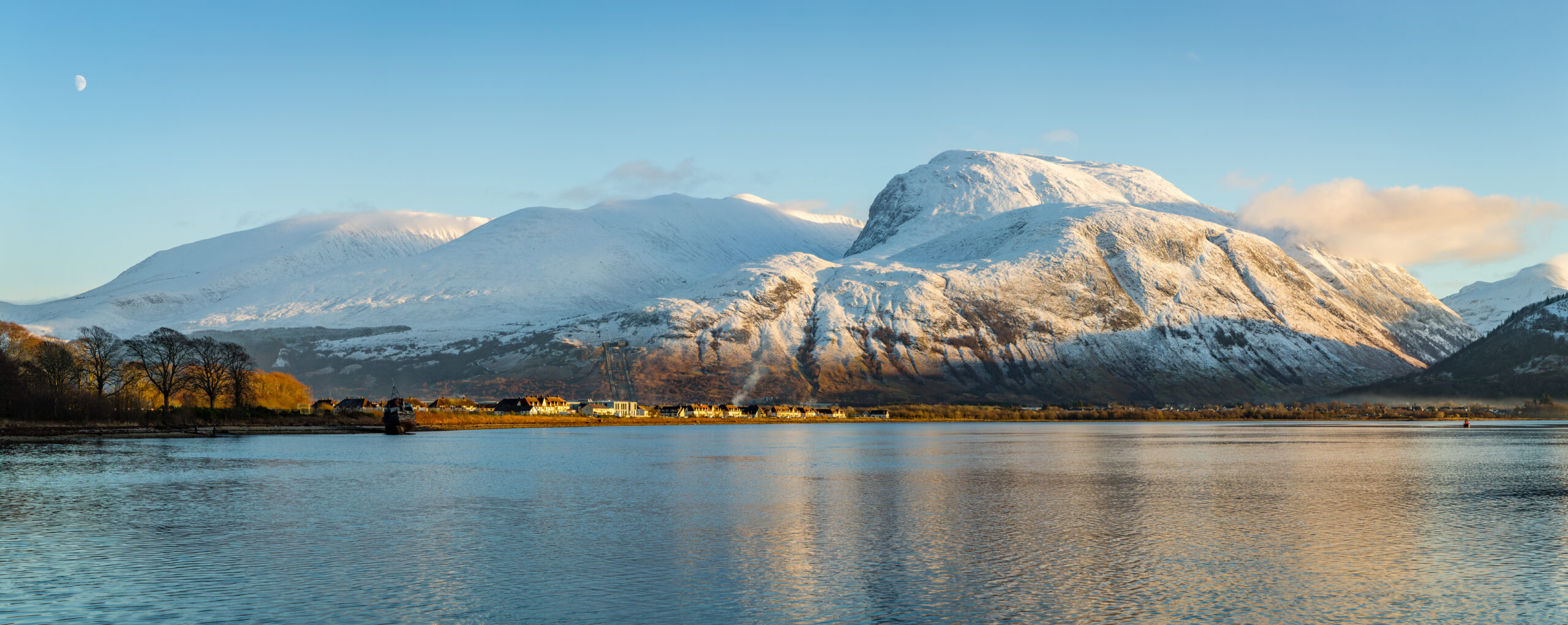
Ben Nevis (1,345 m / 4,413 ft) is the highest mountain in the United Kingdom, Scotland, and the British Isles, located in the Lochaber district of the Scottish Highlands approximately 2 km southeast of Fort William. Generally the mountain is climbed primarily via the Mountain Track (also called the Tourist Path or Pony Track) — a 16-17 km round-trip hike from Glen Nevis Visitor Centre (~20m elevation) used by approximately 95% of the 100,000+ annual climbers. Specifically the Gaelic name Beinn Nibheis is variously translated as “venomous mountain” or “mountain with its head in the clouds” — both reflecting the mountain’s reputation for severe weather. The first recorded ascent was made August 17, 1771, by Scottish botanist James Robertson conducting plant collection work for the University of Edinburgh’s Royal Botanic Garden. Notably Ben Nevis is the highest of the three peaks in the National Three Peaks Challenge (alongside Snowdon at 1,085m in Wales and Scafell Pike at 978m in England), and the mountain claims approximately 5-10 fatalities per year despite the modest elevation — making it substantially more dangerous than the “Tourist Path” naming suggests.
Key Takeaways
- Ben Nevis is 1,345m / 4,413 ft — the highest mountain in the UK, Scotland, and the British Isles.
- The Mountain Track is the standard route at 16-17 km round-trip with full 1,345m vertical gain from sea level. ~95% of summits use this route.
- The Gaelic name Beinn Nibheis means “mountain with its head in the clouds” — reflecting the ~261 cloud days per year on the summit.
- First climbed August 17, 1771 by Scottish botanist James Robertson conducting plant collection for the University of Edinburgh.
- The Ben Nevis Observatory operated 1883-1904 on the summit conducting continuous meteorological observations — ruins still visible today.
- ~100,000+ climbers attempt the mountain annually via the Mountain Track from Fort William.
- ~5-10 climbers die per year — substantially more dangerous than the modest elevation suggests due to weather, navigation, and underestimation.
- The CMD Arête (Carn Mor Dearg Arête) is the scenic alternative requiring scrambling experience and confidence on exposed terrain.
- The Three Peaks Challenge centerpiece — typically climbed first in the 24-hour challenge alongside Snowdon (1,085m) and Scafell Pike (978m).
Why Ben Nevis
Ben Nevis is the highest mountain in the United Kingdom — a 1,345m (4,413 ft) peak in the Scottish Highlands near Fort William that draws over 100,000 hikers per year via the famous Mountain Track (“Tourist Path” or “Pony Track”). Generally, despite the “modest” elevation compared to Alpine giants, Ben Nevis starts essentially at sea level — meaning the full 1,345m of vertical gain over an 8 km climb is genuinely demanding. Specifically, the mountain is the highest and most demanding of the three peaks in the National Three Peaks Challenge (joined by Snowdon in Wales and Scafell Pike in England). Notably, Scottish weather makes Ben Nevis genuinely dangerous — approximately 5-10 fatalities per year — and the “Tourist Path” name creates persistent dangerous underestimation.
The UK’s Highest Mountain: Ben Nevis and the Scottish Highlands
Ben Nevis rises 1,345 meters (4,413 feet) above sea level in the Grampian Mountains of the Scottish Highlands — making it the highest mountain in the United Kingdom, the highest in Scotland, and the highest in the British Isles. Generally, the mountain is a complex Devonian granite massif with a dramatic North Face that includes some of the most serious climbing terrain in Britain, and a more accessible western side that hosts the famous Mountain Track tourist route.
The summit features a relatively flat plateau approximately 100 hectares in area at elevations above 1,200m. Specifically, key summit features include: the concrete trig point marking the actual highest point at 1,345m; the ruins of the historic Ben Nevis Observatory (operational 1883-1904); the small emergency shelter built into the observatory ruins for storm-trapped climbers; multiple memorial plaques to climbers who have died on the mountain; and substantial cairns marking the safe route across the plateau (essential for navigation in poor visibility). Notably, the North Face of the mountain features dramatic cliffs over 700 meters tall — the largest cliff face in the British Isles — including the famous Tower Ridge, the Orion Face, and Carn Mor Dearg.
The Gaelic Name — “Beinn Nibheis”
The mountain’s Gaelic name Beinn Nibheis has multiple translations depending on the source. Generally, the most commonly cited interpretations are: “venomous mountain” or “malicious mountain” — reflecting the mountain’s reputation for severe weather and dangerous conditions; “mountain with its head in the clouds” — reflecting the persistent cloud cover that wraps the summit (averaging 261 days per year with cloud below 1,250m); “sacred mountain” or “mountain of heaven” — alternative spiritual interpretations from some Gaelic sources.
Specifically, the exact etymology is contested among Scottish Gaelic scholars, but the prevailing interpretations consistently emphasize the mountain’s weather severity and dramatic atmospheric presence rather than its physical features. Notably, the name reflects the broader Scottish Gaelic tradition of naming mountains for their distinctive qualities — Ben Nevis’s defining feature is unquestionably its weather. The shortened English form “The Ben” (rhyming with “den”) is the universal local term in Lochaber and Fort William.
The Lochaber Setting and Fort William
Ben Nevis sits within the Lochaber district of the Scottish Highlands — a sparsely populated area defined by dramatic mountainous terrain, deep glens, and a rich Gaelic heritage. Generally, the mountain is part of the Grampian Mountains range, which extends across the central and eastern Scottish Highlands. Specifically, the town of Fort William (population approximately 10,500) is the largest settlement in Lochaber and serves as the standard staging town for Ben Nevis climbs. Fort William sits at the southern end of the Great Glen at the head of Loch Linnhe, approximately 2 km west of the Ben Nevis trailhead.
The surrounding area includes the dramatic Glen Nevis valley directly south of the mountain (the standard approach), the famous Glen Coe further south (one of Scotland’s most photographed glens), and the Caledonian Canal connecting Loch Linnhe through the Great Glen to Inverness. Notably, Fort William is officially designated the “Outdoor Capital of the UK” by Scottish tourism authorities — reflecting the substantial outdoor activity infrastructure built around Ben Nevis, the West Highland Way long-distance trail, and the broader Lochaber outdoor recreation economy.
17 August 1771: The First Recorded Ascent
James Robertson — Scottish Botanist, University of Edinburgh
The first recorded ascent of Ben Nevis was made on August 17, 1771, by Scottish botanist James Robertson, who was conducting plant collection work for the University of Edinburgh’s Royal Botanic Garden. Generally, Robertson’s ascent followed the route now broadly known as the Mountain Track — the gradual approach via Glen Nevis and the broad southwestern slopes. Specifically, the climb was undertaken as scientific botanical work rather than recreational mountaineering; Robertson collected substantial Alpine plant specimens during the ascent, contributing to early Scottish botanical literature.
Robertson’s 1771 ascent was followed in 1774 by John Williams, another Scottish naturalist conducting geological survey work. Generally, by the late 18th century, the mountain had become a known destination for scientific expeditions, though recreational climbing remained rare. Notably, the mountain became increasingly accessible during the 19th century with improved roads to Fort William and the construction of the Mountain Track as a formal route in the 1880s (originally built to support pony-train access to the planned Ben Nevis Observatory at the summit).
1883-1904: The Ben Nevis Observatory Era
The Most Ambitious Mountain Observatory in British History
Between 1883 and 1904, the Ben Nevis summit was home to one of the most ambitious mountain weather observatories ever constructed in the British Isles. Generally, the Ben Nevis Observatory was built in 1883 by the Scottish Meteorological Society to conduct continuous meteorological observations at altitude — providing the first scientific data on weather conditions at a substantial mountain summit in Britain. Specifically, the observatory operated continuously through extreme conditions, with staff overwintering on the summit in genuinely brutal conditions including winds exceeding 150 mph and temperatures well below -20°C.
The observatory’s construction required building the formal “Pony Track” from Glen Nevis to the summit — establishing the route that would eventually become the modern Mountain Track. Generally, supplies were transported up the mountain by pony trains (giving the route its alternative name). Specifically, the observatory operated for 21 years, generating an extraordinary dataset of high-altitude British weather observations. Notably, the observatory closed in 1904 due to funding difficulties despite the scientific value of the data. The ruins remain visible on the summit today and have been incorporated into the modern emergency shelter — providing storm refuge for climbers caught in severe weather.
How to Climb Ben Nevis: All 4 Major Routes
Ben Nevis offers four major route categories from the standard Mountain Track to the most serious North Face technical climbing in Britain. Generally, the Mountain Track is used by approximately 95% of summit attempts and is the only route appropriate for hill walkers without scrambling or technical climbing experience. Specifically, below is the full route inventory.
| Route | Distance / Vertical | Duration | Status |
|---|---|---|---|
| Mountain Track (Tourist Path / Pony Track) | 16-17 km RT · 1,345m gain | 7-9 hours (4-5 up + 3-4 down) | ● Standard Route · 95% of summits |
| CMD Arête (Carn Mor Dearg Arête) | ~17 km · 1,500m gain | 9-11 hours | ● Experienced Hillwalkers |
| Ledge Route | ~14 km · 1,400m gain | 9-12 hours | ● Scrambling experience required |
| Tower Ridge / Castle Ridge | Various | 10-15+ hours | ● Technical Alpine Climbing Only |
| Three Peaks Challenge (Ben Nevis section) | 16-17 km · 1,345m gain | 5-6 hours target | ● Mountain Track + transport timing |
Mountain Track (Tourist Path / Pony Track) — The Standard Route
The Mountain Track — 16-17 km Round-Trip
Style: Long-distance hill walking · The route used by 95% of summit attempts.
The route progression:
- Glen Nevis Visitor Centre (20m elevation): Starting point for most climbers. Car park (£3 for cars, £10 for minibuses), toilets, information boards, and the standard route start. Brief 100m walk to the Mountain Track trailhead at Achintee.
- Achintee Farm / Alternative Start (35m): Alternative trailhead via the Achintee Farm car park. Adds approximately 1 km but provides a slightly different valley experience.
- Glen Nevis Youth Hostel Start (90m): Third trailhead option for those staying at the youth hostel. Slightly shorter than the visitor centre start.
- Initial Ascent (20m → 250m, first 1.5-2 km): The path begins with a steady climb up Glen Nevis. Well-graded path with some rocky sections.
- Path Junction (350m): Junction with a path heading to the half-way lochan and the Carn Mor Dearg approach. Continue straight for the standard Mountain Track.
- Lochan Meall an t-Suidhe (“Half-Way Lochan”) (570m, 4-5 km): The famous “half-way lochan” — actually less than half the elevation but commonly referenced as the halfway point. Small mountain lake with substantial views. Standard timing to reach the lochan: 1.5-2 hours from the visitor centre.
- The Zig-Zags (570m → 1,200m, 3-4 km): The most distinctive section of the Mountain Track — a long zigzag path ascending the western slopes of Ben Nevis. Substantial elevation gain (~630m over ~3 km). Wind exposure begins to increase substantially.
- Summit Plateau (1,200m → 1,345m, final 1 km): The path emerges onto the broad summit plateau. Substantial cairns mark the route — essential for navigation in poor visibility.
- Summit (1,345m): The trig point marks the actual highest point. The observatory ruins and emergency shelter are immediately adjacent. Substantial care required near the North Face cliff edges — multiple historic fatalities have occurred when climbers wandered off the plateau edges in poor visibility.
Generally, the summit plateau is genuinely disorienting in cloud or poor visibility — the broad flat terrain provides no obvious cues for direction. Specifically, climbers have died on multiple occasions by walking off the cliff edges of the North Face after losing the path on descent. The safe descent route follows the cairn line exactly; in poor visibility, take compass bearings from the trig point and follow them precisely back to the path. Notably, carry the OS Explorer 392 map and a compass at minimum — even in good weather, conditions can change rapidly.
CMD Arête (Carn Mor Dearg Arête) — The Scenic Alternative
The CMD Arête — The More Demanding Route
The Carn Mor Dearg Arête (commonly called the “CMD Arête”) is the more demanding alternative route to Ben Nevis. Generally, the route involves climbing the neighboring Carn Mor Dearg (1,220m, a separate Munro) and then traversing the dramatic CMD Arête ridge to the Ben Nevis summit. Specifically, the route offers substantially more scenic mountain views than the Mountain Track and avoids the crowds on the standard path — but requires scrambling experience and confidence on exposed terrain.
The route progression:
- Glen Nevis Visitor Centre / North Face Car Park (20m): Two standard starting points.
- Allt a’ Mhuilinn approach (20m → 700m, 4-5 km): The path follows the Allt a’ Mhuilinn stream up the eastern side of Ben Nevis with substantial views of the dramatic North Face cliffs throughout.
- CIC Hut (680m): Mountain hut at the base of the North Face climbing area. Used by Scottish winter climbers.
- Carn Mor Dearg summit (1,220m): The first summit of the route. Substantial views of Ben Nevis’s North Face from this excellent vantage point.
- The CMD Arête (1,150-1,220m, ~1.5 km): The dramatic ridge connecting Carn Mor Dearg to Ben Nevis. Approximately 1.5 km of exposed scrambling on a narrow ridge with substantial drops on both sides.
- Final ascent to Ben Nevis (1,220m → 1,345m): Steep scrambling section from the end of the CMD Arête up to the Ben Nevis summit plateau.
- Descent via Mountain Track: Most climbers descend via the Mountain Track rather than reversing the CMD route.
Required experience: Confident scrambling on exposed terrain; previous experience on grade 1-2 scrambles; good fitness for the 1,500m total ascent; navigation competence; weather management experience. Not suitable for: First-time Ben Nevis climbers, climbers without scrambling experience, climbers without navigation skills.
North Face Technical Climbing — Britain’s Premier Winter Climbing Venue
The North Face — 700m of British Big Wall
Ben Nevis’s North Face hosts the most serious climbing terrain in the British Isles — over 700 meters of cliff face featuring approximately 100 documented climbing routes ranging from straightforward winter scrambles to elite mixed climbs. Generally, the North Face is particularly famous as Britain’s premier Scottish winter climbing venue, with conditions typically reliable from January through April. Specifically, summer rock climbing also exists but is overshadowed by the winter climbing tradition.
Major North Face climbing routes:
- Tower Ridge (Grade III/IV winter; Difficult summer): One of Britain’s most famous mountaineering routes. Long alpine ridge route ascending the right side of the North Face. 600m of climbing with multiple distinct sections including the Eastern Traverse and the Tower Gap. First climbed March 31, 1894, by Norman Collie, Joseph Collier, and Solly Robinson. Approximately 5-8 hours for the full route depending on conditions.
- Orion Face Direct (Grade V winter): One of the most coveted Scottish winter climbs. 600m of sustained ice and mixed climbing up the central buttress of the Orion Face. First climbed 1959 by Robin Smith and Jimmy Marshall in their famous “Smith-Marshall Week” of Scottish winter ascents.
- Centurion (HVS / Severe summer): The most famous summer rock climb on Ben Nevis. 220m of sustained rock climbing on Carn Dearg Buttress.
- Point Five Gully (Grade V winter): Classic 300m winter ice climb. One of Scotland’s most respected ice routes.
- Zero Gully (Grade V winter): Adjacent classic ice gully. Similar character to Point Five.
- Castle Ridge (Difficult summer; Grade III winter): Alternative ridge route on the right side of the North Face. Less committing than Tower Ridge.
The Scottish winter climbing tradition: Ben Nevis is the spiritual home of Scottish winter climbing — a discipline distinct from Alpine winter climbing due to its rapid weather changes, mixed turf-rock-ice climbing, and substantial commitment levels. The standard Scottish winter season runs January-April with weather windows of 2-7 days separated by storm periods. The CIC Hut at the base of the North Face provides accommodation for serious winter climbers; bookings essential.
The Ben Nevis Section of the National Three Peaks Challenge
Ben Nevis — The Highest of Three British Peaks
The Ben Nevis section of the National Three Peaks Challenge is typically completed FIRST in the challenge sequence — starting around 4-5 PM in summer when daylight extends to ~10 PM at Scotland’s northern latitude.
The Three Peaks Challenge — Ben Nevis as Centerpiece
| Peak | Country | Elevation | Ascent | Standard Section Time |
|---|---|---|---|---|
| Ben Nevis | Scotland | 1,345 m / 4,413 ft | 1,345m (sea level start) | 5-6 hrs (typically first) |
| Scafell Pike | England | 978 m / 3,209 ft | ~900m | 4-5 hrs (typically middle of night) |
| Snowdon | Wales | 1,085 m / 3,560 ft | ~750m via Pyg Track | 4-5 hrs (typically last) |
| Total climbing | — | 3,408 m combined | ~3,000m total ascent | ~13-15 hrs climbing |
| Total Challenge | — | — | ~3,000m combined | < 24 hours |
Why Ben Nevis comes first: Generally, the traditional Three Peaks Challenge order is Ben Nevis → Scafell Pike → Snowdon for several reasons: (1) Ben Nevis at the northernmost point allows participants to drive south through the night with diminishing distances between subsequent peaks; (2) Scotland’s longest summer daylight (16-17 hours at midsummer) provides optimal ascent conditions for the most demanding section; (3) the geographic distribution makes the south-driving sequence substantially more efficient than the reverse. Notably, approximately 80-90% of Three Peaks attempts follow the Ben Nevis-first sequence.
Why Ben Nevis is the hardest section: Generally, despite being only 1,345m, Ben Nevis is genuinely the most demanding section of the Three Peaks Challenge for multiple reasons: (1) Starting elevation — Ben Nevis starts essentially at sea level (~20m) while Snowdon starts at ~360m and Scafell Pike at ~80m; (2) Distance — the 16-17 km Mountain Track is substantially longer than the Snowdon Pyg Track or Scafell Pike’s standard route; (3) Scottish weather — substantially worse on average than English Lake District or Welsh mountain conditions; (4) Northern latitude exposure — Ben Nevis receives more severe winter weather than the more southerly peaks; (5) The summit plateau navigation — genuinely disorienting in poor visibility. Specifically, Three Peaks Challenge participants who fail typically fail on Ben Nevis or in the immediately following driving section.
Climbing Ben Nevis from Fort William: Complete Logistics
Fort William is the standard staging town for Ben Nevis climbs — a small but substantial Scottish Highlands town with comprehensive tourism infrastructure built around the mountain and the broader Lochaber outdoor recreation economy. Generally, Fort William is officially designated the “Outdoor Capital of the UK” by Scottish tourism authorities. Specifically, the town has been the Ben Nevis staging point since the 1880s when the Ben Nevis Observatory drew the first substantial tourist visits to the mountain.
Getting to Fort William
| From | Distance / Time | Options | Cost (Round Trip) |
|---|---|---|---|
| Glasgow | ~165 km · 2.5-3 hrs drive | Car, ScotRail train via West Highland Line, CityLink 914 bus | £40-£80 |
| Edinburgh | ~225 km · 3.5-4 hrs drive | Car, train via Glasgow connection, CityLink bus | £60-£120 |
| Inverness | ~108 km · 1.5-2 hrs drive | Car, ScotRail train via Glen Coe (scenic) | £40-£70 |
| London | ~875 km | Caledonian Sleeper overnight train, flight to Glasgow/Edinburgh + onward | £150-£400 (sleeper) / £100-£250 (flight + train) |
| International | — | Flight to Glasgow (GLA) or Edinburgh (EDI), then train or bus to Fort William | $600-$1,500 from major North American cities |
Generally, one of the UK’s most distinctive long-distance services — the Caledonian Sleeper overnight train from London Euston to Fort William. Specifically, the Highland Sleeper departs London Euston around 9:15 PM, runs overnight north through Crewe, Preston, and into Scotland, separating at Edinburgh with the Highland portion continuing through Glasgow Queen Street, Crianlarich, and arriving at Fort William around 9:30-10:00 AM. The journey takes approximately 12 hours total and provides one of the most scenic rail experiences in Britain. Sleeper berths cost £150-£400 depending on accommodation class. The arrival time at Fort William allows direct continuation to Ben Nevis on the same day for climbers seeking efficient logistics. Booking via sleeper.scot.
From Fort William to the Mountain Track Trailhead
The Ben Nevis Visitor Centre trailhead is approximately 2 km from Fort William town centre. Generally, options include:
- Drive: 5-10 minutes via Glen Nevis Road. Postcode for satellite navigation: PH33 6ST. Parking at the Visitor Centre car park: £3 for cars, £10 for minibuses/coaches. Spaces fill quickly during peak season (June-August weekends) — arrive by 8-9 AM for guaranteed parking.
- Walk: 30-40 minutes from Fort William town centre via the Cow Hill path or Glen Nevis Road. A pleasant warm-up but adds substantial time to the day.
- Local bus or taxi: Stagecoach Bus Service 41 from Fort William to Glen Nevis runs at limited intervals. Taxis approximately £10-£15 each way.
- Ben Nevis Inn: The Ben Nevis Inn is located near the Achintee trailhead and provides accommodation, food, and direct trailhead access.
Fort William Accommodation
| Accommodation Type | Per-Night Cost | Notable Options |
|---|---|---|
| Hostel (dorm bed) | £25-£45 | Glen Nevis Youth Hostel (closest to trailhead), Fort William Backpackers |
| B&B (mid-range) | £60-£120/room | Numerous family B&Bs in and around Fort William town centre |
| Hotel (mid-range) | £80-£180/room | Ben Nevis Hotel, Cruachan Hotel, Premier Inn Fort William |
| Hotel (premium) | £180-£400/room | Inverlochy Castle Hotel, Lime Tree Hotel |
| Self-catering / lodge | £100-£300/night | Glen Nevis Caravan & Camping Park, various holiday cottages |
| Camping | £10-£25/pitch | Glen Nevis Caravan & Camping Park, wild camping permitted on Scottish open land |
| Ben Nevis Inn (Achintee) | £60-£150/room | Closest accommodation to the Mountain Track trailhead |
Ben Nevis Historical Timeline
| Date | Event | Significance |
|---|---|---|
| ~400 Million Years Ago | Devonian Granite Formation | Granite intrudes into Earth’s crust during Devonian period. Part of broader Glen Coe / Lochaber volcanic complex. |
| ~2 Million Years Ago | Glacial Carving | Pleistocene glaciation carves dramatic Lochaber landscape. North Face cliffs excavated by ice; summit plateau shaped by ice scouring. |
| ~6th-12th Century CE | Gaelic Naming | Mountain receives Gaelic name “Beinn Nibheis” — “venomous mountain” or “mountain with its head in the clouds.” |
| 17 August 1771 | First Recorded Ascent | Scottish botanist James Robertson makes first recorded ascent during plant collection for University of Edinburgh Royal Botanic Garden. |
| 1774 | Williams Geological Survey | John Williams makes documented geological survey ascent — establishing early pattern of scientific interest. |
| 1880-1883 | Pony Track Constructed | Formal “Pony Track” from Glen Nevis to summit constructed to support Ben Nevis Observatory. |
| 17 October 1883 | Ben Nevis Observatory Opens | One of most ambitious mountain weather observatories ever in British Isles begins continuous meteorological observations. |
| 31 March 1894 | Tower Ridge First Ascent | Norman Collie, Joseph Collier, and Solly Robinson make first ascent of Tower Ridge — establishing Ben Nevis as serious mountaineering destination. |
| 1904 | Observatory Closes | Ben Nevis Observatory closes after 21 years of continuous operation due to funding difficulties. |
| 1928 | CIC Memorial Hut Built | Charles Inglis Clark Memorial Hut built at base of North Face by Scottish Mountaineering Club. |
| 1959 | Orion Face Direct First Ascent | Robin Smith and Jimmy Marshall make first ascent of Orion Face Direct during famous “Smith-Marshall Week” of Scottish winter ascents. |
| 1980s | Three Peaks Challenge Popularizes | National Three Peaks Challenge becomes increasingly popular as charity fundraising — transforming Ben Nevis into UK-wide outdoor challenge centerpiece. |
| 1990s-2000s | Tourism Growth | Annual climbers grow from ~40,000 in 1990 to ~100,000+ by 2010. Glen Nevis Visitor Centre opens to support growing visitor numbers. |
| 2017 | Outdoor Capital Designation | Fort William officially designated “Outdoor Capital of the UK” by Scottish tourism authorities. |
| 2025-2026 | Continued Iconic Status | Ben Nevis continues to receive 100,000+ annual climbers via Mountain Track. Three Peaks Challenge remains a major British outdoor activity. |
Ben Nevis Weather and Safety: Why This “Modest” Mountain Is Genuinely Dangerous
Ben Nevis claims approximately 5-10 fatalities per year despite being only 1,345m. Generally, the mountain is genuinely more dangerous than its elevation suggests for a combination of weather, navigation, and underestimation factors that visitors often discover too late. Specifically, understanding these factors is essential — not as fearmongering but as honest preparation for what the mountain actually requires.
Why Ben Nevis Is Dangerous Despite the Modest Elevation
Five specific factors combine to make Ben Nevis substantially more dangerous than its 1,345m elevation suggests:
- 1. The “Tourist Path” name creates persistent dangerous underestimation. The Mountain Track’s alternative name “Tourist Path” suggests a casual walk — but the route requires substantial fitness, proper equipment, and navigation skills. Many climbers attempt the mountain in trainers, jeans, and cotton clothing with no map or compass. The Mountain Rescue Team in Lochaber responds to 80-120 incidents per year on Ben Nevis.
- 2. Sea-level start means full 1,345m of vertical ascent. Most climbers underestimate the physical demands of climbing 1,345m of vertical from sea level. The ascent is substantially more demanding than the elevation suggests.
- 3. Scottish weather is genuinely severe. The summit experiences ~261 days per year with cloud below 1,250m, summit temperatures averaging 8°C below valley temperatures even in summer (with wind chill making the effective temperature substantially colder), wind speeds regularly exceeding 100 km/h, and rapid weather deterioration.
- 4. The summit plateau is dangerously disorienting in poor visibility. The broad flat summit plateau provides no obvious navigation cues — climbers can become genuinely lost within 100 meters of the trig point in cloud. The summit cliff edges are not marked with barriers; in cloud, the only safety lies in following the cairns and compass bearings exactly.
- 5. The descent is when most accidents occur. Climbers fatigue during the ascent, become careless on the descent, and account for the majority of injuries and fatalities. The loose terrain of the upper zig-zags and summit plateau is particularly treacherous when descending tired.
| Period | Window | Conditions | Watch For |
|---|---|---|---|
| Peak Climbing Season | June – August | Warmest summit temps (8-15°C); longest daylight (16-17 hrs); driest conditions; full visitor centre operations | Substantial weekend crowds; weekend parking fills early; book accommodation 1-2 months in advance |
| Shoulder Season | May + September | Substantially fewer crowds; still-reliable conditions; substantial daylight | Snow may persist on summit until mid-June; weather more variable |
| Spring Transition | April | Some climbing possible in good conditions; substantial snow on summit | Substantial snow cover requires winter equipment; navigation can be challenging |
| Autumn Transition | October | Variable conditions; substantial cloud cover days; daylight reducing | Early snow possible; not recommended for first-time visitors |
| Winter Climbing | November – March | Scottish winter climbing on the North Face; Mountain Track requires winter equipment | Genuine winter mountaineering required; substantial fatalities annually |
Generally, the Mountain Track in winter (November-March) is fundamentally different from the summer route — substantial snow cover, hidden ice, freezing temperatures (often -10 to -20°C with wind chill), and the genuine risk of avalanche on the upper sections. Specifically, winter ascents require Scottish winter climbing experience including ice axe and crampons technique, avalanche awareness, navigation in whiteout conditions, and the ability to abort safely when conditions deteriorate. Notably, the majority of annual Ben Nevis fatalities occur in winter — typically inexperienced climbers attempting summer technique on winter conditions. The Scottish Avalanche Information Service (SAIS) provides daily avalanche forecasts at sais.gov.uk.
Generally, the Mountain Weather Information Service (MWIS) provides specialized mountain weather forecasts that account for elevation effects, wind chill, and the rapid changes typical at Ben Nevis. Specifically, standard valley weather forecasts substantially underestimate summit conditions. The MWIS Scotland West forecast (covering Ben Nevis) is updated twice daily and available at mwis.org.uk. Notably, climbers should check MWIS within 24 hours of their planned ascent and again the morning of the climb. If MWIS forecasts wind speeds above 60 km/h, cloud base below 1,000m, or precipitation greater than light showers, consider postponing.
Essential Gear Checklist for Ben Nevis
Ben Nevis gear requirements depend on the season and route, but the standard rule applies year-round: pack for summit conditions, not valley conditions. Generally, the summit can be genuinely arctic even when Fort William is sunny and warm.
📍 Navigation (Mandatory)
- OS Explorer 392 map (mandatory)
- Compass + knowledge to use it (mandatory)
- Headlamp with spare batteries
- Mobile phone with offline maps backup
- Emergency shelter / bivvy bag
- Whistle for emergencies
🥾 Summer Mountain Track (Jun-Aug)
- Sturdy hiking boots (broken in, waterproof)
- Hiking socks + spare pair
- Long pants for sun/brush/wind
- Base layer + insulating mid-layer (fleece)
- Waterproof jacket (mandatory)
- Waterproof pants (recommended)
- Warm hat / beanie (essential)
- Light gloves (summit can freeze)
- Sunglasses + sunscreen SPF 30+
- 30-40L hiking backpack
- 2-3 liters water + 3,000-4,000 calories food
❄ Winter Mountain Track (Nov-Apr)
- Mountaineering boots (rigid soles for crampons)
- Crampons (general mountaineering, 10-12 point)
- Ice axe (60-70cm general mountaineering)
- Substantial insulating layers (down jacket)
- Hardshell jacket and pants (storm-rated)
- Mountaineering gloves + liners (waterproof)
- Goggles for snow conditions
- Balaclava / face protection
- Heavy-duty waterproof gaiters
- Avalanche transceiver / shovel / probe ideal
- Substantial additional spare batteries
🧗 CMD Arête Route (Summer)
- Same as summer Mountain Track kit, plus:
- Climbing helmet (rockfall hazard on arête)
- Trekking poles useful for ascent, stowed for scrambling
- Light gloves for handholds on arête
- Greater fitness for 1,500m vs 1,345m ascent
- Substantial water and food for 9-11 hours
- Earlier start than Mountain Track
⏰ Three Peaks Challenge
- Same as summer Mountain Track kit, plus:
- Headlamp (mandatory — Scafell Pike at night)
- Substantial spare batteries
- Energy gels and quick-energy food
- Multiple base layer changes
- Phone power bank
- Travel-pack for driving sections
- Booked minibus charter or driver rotation
🚑 Emergency Resources
- 999 + ask for “Mountain Rescue”
- Lochaber Mountain Rescue Team (~80-120 incidents/yr)
- Emergency shelter / bivvy bag
- Basic first aid kit
- Spare warm clothing in pack
- Garmin inReach for remote sections
The 8 Common Mistakes First-Time Ben Nevis Climbers Make
Avoid These Planning and Climbing Failures
- Taking the “Tourist Path” name literally. Generally the Mountain Track is not a casual tourist walk — it requires substantial fitness, proper equipment, and navigation skills. Specifically, attempting the mountain in trainers and cotton clothing is the documented failure pattern.
- Skipping the OS Explorer 392 map and compass. Generally the summit plateau disorients in cloud — multiple historic fatalities have occurred from navigation failures. Specifically, the map and compass are mandatory, not optional.
- Underestimating Scottish weather. Generally the summit experiences ~261 cloud days per year and winds regularly over 100 km/h. Specifically, valley weather forecasts substantially underestimate summit conditions — use MWIS Scotland West, not BBC Weather.
- Starting too late. Generally fit walkers should depart by 8-9 AM for comfortable descent in daylight. Specifically, climbers running out of daylight on the descent face genuinely serious conditions including the disorienting summit plateau.
- Ignoring the descent. Generally most Ben Nevis accidents happen on descent when climbers are fatigued. Specifically, save energy for the way down and maintain navigation discipline through fatigue.
- Attempting winter without winter skills. Generally winter Mountain Track is fundamentally different from summer — substantial snow, hidden ice, freezing temperatures, and avalanche risk. Specifically, the majority of annual fatalities occur in winter from inexperienced climbers attempting summer technique on winter conditions.
- Failing to book accommodation. Generally Fort William accommodation books out 1-2 months ahead during peak summer season. Specifically, weekend parking at Glen Nevis Visitor Centre also fills early — arrive by 8-9 AM for guaranteed parking.
- Attempting CMD Arête without scrambling experience. Generally the CMD Arête is exposed Grade 1-2 scrambling on a narrow ridge with substantial drops both sides. Specifically, multiple fatalities have occurred from climbers slipping off the ridge in poor weather — this is not a step-up from the Mountain Track for first-time Ben Nevis climbers.
Featured Ben Nevis Operators & Resources
The Ben Nevis tourism infrastructure is one of the most developed in the UK, with substantial guide services, gear rental, accommodation, and Three Peaks Challenge organization. Generally, below are the established resources for 2026.
Abacus Mountain Guides
Fort William-based mountain guide service offering Ben Nevis day climbs, winter ascents, and CMD Arête guided routes. Generally, Mountain Leader and IFMGA-certified guides. Specifically, pricing typically £100-£200 per person for guided day climbs (£300-£500 for private groups). One of the most established Fort William guide services with substantial reputation. abacusmountaineering.com
West Coast Mountain Guides
Lochaber-based guide service specializing in Ben Nevis and broader Scottish Highlands climbing. Generally, comprehensive offering across summer hill walking, winter mountaineering, and technical climbing. Specifically, pricing comparable to Abacus.
Three Peaks Challenge Companies
Multiple companies organize Three Peaks Challenge attempts with guides, transport, and safety management. Generally, popular operators include threepeakschallenge.uk, Pure Adventure, and Across the Divide. Specifically, pricing typically £200-£400 per person including guides, minibus charter, and safety briefings. Notably, strongly recommended for first-time Three Peaks attempters.
Trekking Tom Guided Hikes
Popular Fort William-based Mountain Leader providing guided Ben Nevis ascents. Generally, often featured in regional outdoor media; substantial local reputation for first-time climber friendly guided walks.
Glen Nevis Visitor Centre
Operated by Highland Council; provides essential information, current trail conditions, weather reports, and parking. Generally, open daily during the climbing season. Specifically, standard starting point for the Mountain Track.
Scottish Mountaineering Club (SMC)
The SMC operates the CIC Hut at the base of Ben Nevis’s North Face — the central accommodation for serious winter climbers. Generally, SMC also publishes the definitive Ben Nevis climbing guidebook and provides resources for technical climbing. Specifically, smc.org.uk
Mountain Weather Information Service (MWIS): Specialized mountain weather forecasts essential for Ben Nevis attempts. MWIS Scotland West updated twice daily. Standard valley weather substantially underestimates summit conditions. Scottish Avalanche Information Service (SAIS): Daily avalanche forecasts for Scottish mountains. Essential for any winter Ben Nevis attempt. Lochaber Mountain Rescue Team: The volunteer team responds to 80-120 incidents per year on Ben Nevis. Climbers in difficulty should call 999 and ask for “Mountain Rescue.” Please donate to support their volunteer work even if you don’t need their services.
Frequently Asked Questions
What is the highest mountain in the UK?
Ben Nevis at 1,345 meters / 4,413 feet is the highest mountain in the United Kingdom, Scotland, and the British Isles. The summit is located in the Lochaber district of the Scottish Highlands, approximately 2 km southeast of Fort William. Ben Nevis is the highest peak in the Grampian Mountains, the highest Munro (Scottish mountain over 3,000 ft), and the highest of the three peaks in the National Three Peaks Challenge. The Gaelic name “Beinn Nibheis” is variously translated as “mountain with its head in the clouds,” “venomous mountain,” or “malicious mountain” — all reflecting the mountain’s reputation for severe weather. The summit features the ruins of the historic Ben Nevis Observatory (operational 1883-1904) and is visited by approximately 100,000+ climbers annually.
How do you climb Ben Nevis?
Ben Nevis is climbed primarily via the Mountain Track (also called the Tourist Path or Pony Track) — a 16-17 km / 10-11 mile round-trip hiking route starting from the Ben Nevis Visitor Centre at Glen Nevis (approximately 20m elevation, 2 km from Fort William). The route ascends 1,345m of total elevation gain — substantially more than any other major UK peak. Standard timing: 7-9 hours round-trip for fit walkers, with 4-5 hours up and 3-4 hours down. The Mountain Track follows a well-defined path through three sections: initial ascent through Glen Nevis to Lochan Meall an t-Suidhe (570m), the famous zig-zag section to the summit plateau (1,200m), and the rocky summit plateau approach to the trig point. No technical climbing equipment required but substantial fitness, weather-appropriate gear, navigation skills, and the OS Explorer 392 map are essential.
How dangerous is Ben Nevis?
Ben Nevis is substantially more dangerous than its 1,345m elevation suggests, claiming approximately 5-10 fatalities per year. Five factors: (1) The “Tourist Path” name creates persistent dangerous underestimation — many climbers attempt the mountain in trainers and cotton clothing; (2) Sea-level start means full 1,345m vertical ascent — substantially more demanding than other UK peaks; (3) Scottish weather is genuinely severe — 261 days/year with cloud below 1,250m, regular winds over 100 km/h, freezing summit temperatures even in summer; (4) The summit plateau is dangerously disorienting in poor visibility — multiple historic fatalities from climbers walking off North Face cliffs in cloud; (5) Most accidents occur on descent when climbers are fatigued. Always carry the OS Explorer 392 map and compass, check the MWIS Scotland West forecast within 24 hours of climbing, and turn around if weather deteriorates beyond your skill level.
How does Ben Nevis fit in the Three Peaks Challenge?
Ben Nevis is the highest and most demanding of the three peaks in the National Three Peaks Challenge — the famous British hiking challenge requiring climbers to ascend the highest mountain in Scotland (Ben Nevis, 1,345m), Wales (Snowdon, 1,085m), and England (Scafell Pike, 978m) within 24 hours including travel time. Ben Nevis is typically climbed first (starting around 4-5 PM in summer) to capitalize on the longest daylight at Scotland’s northern latitude. The Ben Nevis section requires 5-6 hours including travel between the visitor centre and the summit, plus the substantial driving time to Scafell Pike (typically 6-7 hours from Fort William). The full challenge involves ~23 miles of hiking, 3,000m+ total ascent, and 9-10 hours driving — completed within 24 hours. Ben Nevis is genuinely the most demanding section for elevation (substantially higher than the other two), Scottish weather, and Mountain Track length.
When is the best time to climb Ben Nevis?
The standard Ben Nevis climbing season is May through October, with June-August being the peak window. Summer (June-August): warmest summit temperatures (8-15°C with substantial wind chill possible), longest daylight (16-17 hours in midsummer), driest conditions, full visitor centre operations. Average summit temperatures are still substantially cold relative to valley — visitors in shorts at Fort William can encounter freezing conditions at summit. May and September are shoulder months with substantially fewer crowds but more variable weather; snow may persist on summit until mid-June and return from early October. Winter (November-April): the mountain becomes a serious Scottish winter climbing destination requiring substantial alpine mountaineering experience, ice axe and crampons, and avalanche awareness. Winter Mountain Track is genuinely dangerous and accounts for a substantial portion of annual fatalities.
How long does it take to climb Ben Nevis?
The Mountain Track takes 4-5 hours up and 3-4 hours down for fit walkers — total 7-9 hours round-trip. Faster fit hikers complete the climb in 6-7 hours; less fit walkers may need 10-12 hours; Three Peaks Challenge participants target 5-6 hours total to maintain the 24-hour challenge schedule. Breakdown: visitor centre (20m) to Lochan Meall an t-Suidhe (570m) takes 1.5-2 hours; lochan to summit plateau via zig-zags takes 2-3 hours additional; final plateau approach to trig point takes 30-45 minutes. Descent times typically faster but require substantial care — descent is when many accidents occur as climbers fatigue. Full daylight in summer provides ample margin; in shoulder months and winter, start by 8-9 AM to ensure descent completion in daylight.
Sources and Methodology
Sources
This guide synthesizes data from Scottish mountaineering authorities, Lochaber tourism resources, historical mountaineering records, Mountain Rescue incident data, and cross-referenced British hillwalking literature.
- Mountain Weather Information Service (MWIS). Specialized mountain weather forecasts essential for Ben Nevis attempts. MWIS Scotland West forecast updated twice daily. mwis.org.uk
- Scottish Avalanche Information Service (SAIS). Daily avalanche forecasts for Scottish mountains including the Lochaber forecast covering Ben Nevis. sais.gov.uk
- Lochaber Mountain Rescue Team. Volunteer Mountain Rescue Team responding to 80-120 incidents per year on Ben Nevis. Statistics and incident analysis. lochabermrt.co.uk
- Scottish Mountaineering Club (SMC). Operates CIC Hut at base of North Face; publishes definitive Ben Nevis climbing guidebook. smc.org.uk
- Highland Council Glen Nevis Visitor Centre. Authoritative source for current trail conditions, parking information, and seasonal operations.
- James Robertson 1771 botanical records. University of Edinburgh Royal Botanic Garden archives documenting the first recorded ascent on August 17, 1771.
- Ben Nevis Observatory historical records. Scottish Meteorological Society records of the 1883-1904 observatory operations and the unprecedented British high-altitude weather observations.
- Internal Global Summit Guide research. Cross-referenced with our British Isles Peaks Collection, Mountain Weather Guide, and Avalanche Awareness.
Methodology note. Annual review cycle — next review post-2026 Scottish climbing season (October 2026). Mountain Track conditions, Fort William logistics, guide rates, and Three Peaks Challenge organization details change seasonally; verify current information directly with operators, Glen Nevis Visitor Centre, and MWIS forecasts within 2-4 weeks of climb dates. Disclaimer: Ben Nevis is genuinely dangerous despite its modest 1,345m elevation, claiming approximately 5-10 fatalities per year. The “Tourist Path” name does not reflect the actual demands of climbing the UK’s highest mountain in Scottish weather from sea level. This page is educational and not a substitute for professional mountain leader instruction, current weather forecasting, or qualified guiding.
Continue Your Ben Nevis Planning
The UK’s Highest Mountain Deserves Real Respect
Generally, Ben Nevis is not a Tourist Path despite the name — it is genuinely the most-serious mountain accessible to ordinary hill walkers in the British Isles. Specifically, the documented pattern across 250+ years is consistent: most fatalities occur from underestimation, weather surprise, and descent fatigue, on terrain where the modest 1,345m elevation masks the actual demands of climbing from sea level in Scottish weather. Notably, climbers who succeed on Ben Nevis arrive with proper boots and waterproofs, carry the OS Explorer 392 map and compass, check MWIS Scotland West forecasts within 24 hours of the climb, and respect the documented pattern that this beautiful mountain has killed ~5-10 climbers per year for as long as records have been kept.
Read All 4 Routes Three Peaks Challenge →Twenty Twenty-Five
email@example.com
+1 555 349 1806
Was this helpful?
🏔Related peaks nearby
🧭Explore & compare
Global Summit Guide is an independent mountaineering resource founded in 2026. The team combines first-hand trekking and climbing experience with in-depth research and professional health and nutrition review to help climbers choose objectives, prepare properly, and stay safe.
Health, altitude, and nutrition content is reviewed by Taylor Ludlow (Registered Nurse) and Brigg Hoopes (Nutritionist).
What We Don't Know Yet
Mountain information changes quickly. This box explains the limits of what this page can responsibly promise.
- Weather, snowpack, avalanche risk, road access, and route conditions can change quickly and may be different on your climbing dates.
- Route conditions, trailhead access, crevasse exposure, stream crossings, and rescue access may vary from published planning guidance.
- Gear requirements can change by season, route variation, weather window, personal cold tolerance, and guide-service requirements.
Verify current conditions with official land managers, guide services, local forecasts, and current route reports before booking or climbing.
Part of this Global Summit Guide cluster
Explore the complete Mountains guide for more context, routes, planning links, and related resources.
Mountaineering, rock and ice climbing, glacier travel, and high-altitude activity are inherently dangerous and can result in serious injury or death. The information on Global Summit Guide is provided for general informational and educational purposes only and is not a substitute for professional instruction, qualified guiding, proper equipment, or your own judgment and experience.
Route conditions, weather, snowpack, permits, regulations, and hazards change constantly and may differ from what is described here. Details may be incomplete, out of date, or contain errors. Always verify current information with local authorities, certified guides, and official sources before making any decision in the mountains.
Nothing on this site is medical, legal, or financial advice. Our fitness, acclimatization, altitude, and nutrition content is general in nature; consult a qualified physician before beginning any strenuous exercise program or exposing yourself to high altitude.
You are solely responsible for your own safety and decisions. To the fullest extent permitted by law, Global Summit Guide and its team accept no liability for any loss, injury, damage, or expense arising from use of, or reliance on, this information. By using this site you acknowledge these risks and accept these terms.
Some links on this site may be affiliate links. If you buy through them we may earn a small commission at no extra cost to you; this never affects our recommendations.
Global Summit Guide recommendation path
Next Best Mountain to Research
Use these recommendations to continue the right planning path instead of stopping on one page.
Use current permit, weather, route, and operator information before booking or climbing.