
Last updated September 17, 2026
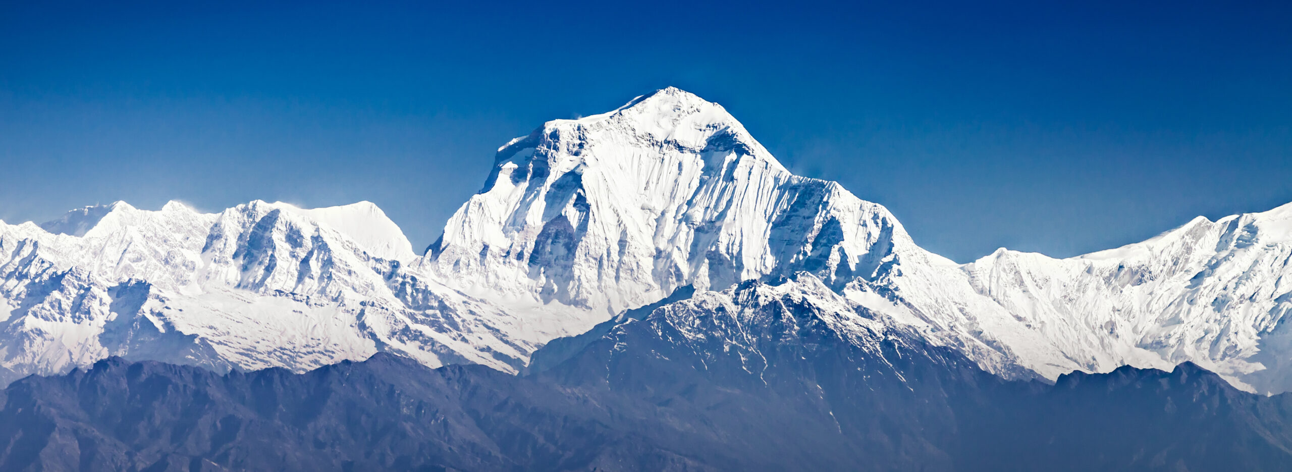
Dhaulagiri Route Comparison: Northeast Ridge, East Face & South Face
The Northeast Ridge is the standard expedition route. Dhaulagiri’s other major lines are historically important, technically serious objectives whose logistics, support and risk profile are not directly comparable with a normal commercial ascent.
For a standard Dhaulagiri expedition, the route decision centers on the Northeast Ridge.
The Northeast Ridge is the route most modern supported expeditions sell and the line tied to Dhaulagiri’s 1960 first ascent. The Southeast and Southwest ridges have summit histories of their own, while the East and South Faces are much more specialized objectives. Some Nepal operators say they can arrange alternative ridge departures on request, but those are bespoke expeditions rather than interchangeable versions of the normal route.
Dhaulagiri routes at a glance
Dhaulagiri is not a mountain where four named lines should be compared like four normal commercial routes. The Northeast Ridge is the repeatable expedition system. The other ridges and faces belong to a mix of historic expedition climbing, custom objectives and elite alpinism.
| Route / line | Modern role | Historical status | Support model | What changes most |
|---|---|---|---|---|
| Northeast Ridge | Standard | First-ascent route, 1960 | Regular supported expeditions | Operator, oxygen, camp plan, rope fixing, forecast and rescue structure |
| Southeast Ridge | Specialist | Summited by a Japanese expedition in 1978 | Bespoke / limited-request model | Longer ridge logistics, team-specific route work and much less standardized infrastructure |
| Southwest Ridge / South Pillar | Specialist | Summited by a Japanese expedition in 1978 | Bespoke / limited-request model | Separate south-side logistics and route-specific technical planning |
| East Face | Elite face objective | Face climbed to the upper ridge in 1980; summit reached later by ridge | Team-designed expedition | Speed, retreat options, snow/ice condition and exact line matter more than standard camp infrastructure |
| South Face | Elite face objective | Face first climbed in 1981 to the upper ridge system; multiple later attempts/lines | Team-designed expedition | Huge wall, objective hazard, route finding, bivouac strategy and escape options |

Northeast Ridge: the route most climbers are actually choosing
The Northeast Ridge was reconnoitered in 1959 and climbed on Dhaulagiri’s first ascent in 1960. It remains the mountain’s normal route. Current commercial programs generally build their oxygen, staffing, camp rotations and summit strategy around this line.
“Normal route” is a logistical description, not a difficulty guarantee. Dhaulagiri still combines remote access, glacier travel, steep snow and ice, avalanche and serac exposure, high winds, extreme altitude and a committing descent. The value of the Northeast Ridge is that teams can plan around an established route system rather than because the mountain becomes straightforward.
Modern guides commonly place the expedition base around 4,700-4,800 m. The exact position and access plan vary with operator and season.
Glacier and snow travel lead toward the ridge system. Crevasse, serac and avalanche conditions can change the safest line and camp placements.
Current operators publish three- or four-camp models above Base Camp. Do not treat any one camp numbering scheme as universal.
The climbing occurs at extreme altitude where wind, snow condition, fixed-line status and fatigue can matter as much as the nominal technical grade.
A successful summit does not end the objective. Weather deterioration and accumulated fatigue make descent planning a primary part of the route decision.
Operator system
Compare guide/Sherpa ratio, oxygen allocation, fixed-line assumptions, forecasting and rescue terms rather than a headline route grade alone.
One camp profile
Camp elevations and numbering vary among modern operators and historical expeditions. Use the current-season plan for logistics.
Not an introductory 8,000er
Prior high-altitude expedition experience, fixed-line efficiency and conservative decision-making are more relevant than a simple difficulty label.

Where Dhaulagiri sits – and why approach language needs care
Dhaulagiri I stands in western Nepal near the Kali Gandaki region. Historical expeditions have reached the mountain through different approach systems, including the Myagdi/Mayangdi valley and routes from the Tukuche side using high passes. The current operator’s access plan matters more than an old one-line description of “the” approach.
Dhaulagiri I orientation map
Summit-centered geographic context. This is not a route track and should not be used for navigation, camp placement or glacier travel.
Documented expedition access
Historical Northeast Ridge expeditions used the Mayangdi valley approach. Modern operator roadheads and porter plans should be confirmed for the actual season.
Also part of the record
The 1980 East Face expedition approached from Tukuche via the Dambush and French passes while noting the Mayangdi River route as the pre-monsoon alternative.

Southeast and Southwest ridges: real summit routes, but not normal-route equivalents
The Southeast Ridge and Southwest Ridge/South Pillar both belong to Dhaulagiri’s established route history. American Alpine Journal reporting records Japanese teams reaching the summit by each ridge in 1978. Those ascents matter because they show that Dhaulagiri’s alternative ridge system is more than a collection of failed historical experiments.
For a modern climber, however, historical completion does not create the same planning environment as the Northeast Ridge. Infrastructure is thinner, route-specific familiarity is rarer, and a team considering one of these ridges needs to verify exactly what an operator or expedition leader means by the route name.
The East Face is a historic technical climb, not a clean commercial alternative
The 1980 Nick Estcourt Memorial Expedition climbed Dhaulagiri’s East Face alpine-style. The American Alpine Journal summary records the face climbed to roughly 7,500 m on the upper ridge, followed by a later summit via a ridge route on May 18. The expedition narrative emphasizes speed, difficult retreat, poor bivouac sites, spindrift and rapidly changing avalanche conditions.
That history is the key comparison point. On the Northeast Ridge, climbers are usually evaluating a support system. On the East Face, an elite team is evaluating a specific line, current ice and snow, speed, bivouac strategy and whether retreat remains possible. The two decisions are fundamentally different.
Exact line
Face conditions can alter the viable line. A generic “East Face” label is less useful than a precise route plan.
Speed matters
The 1980 account repeatedly ties safety to moving quickly through serious snow, ice and bivouac terrain.
Can the team retreat?
Retreat difficulty becomes part of the route itself. That is a different planning problem from supported movement on a normal route.

The South Face is a route family measured in commitment, not a client itinerary
The South Face – more precisely described in American Alpine Journal reporting as the south-southeast face – rises more than 4,000 m and is broken by active seracs and complex rock. In 1981, Stane Belak Srauf, Cene Bercic and Emil Tratnik climbed the right side of the face, joined the Southeast Ridge around 7,185 m and reached about 7,950 m before deteriorating weather forced a descent by the Northeast Ridge.
Later attempts and lines further demonstrate the scale of the wall. Tomaz Humar’s 1999 solo, for example, crossed highly technical ground and ultimately traversed toward the Southeast Ridge before continuing on the upper mountain. The useful lesson is not to compress all of this into one “South Face success rate.” It is to recognize that each line has its own architecture, objective hazards, escape problems and historical context.

The government royalty is the same category regardless of route
Nepal’s Department of Tourism fee schedule effective September 1, 2025 places Dhaulagiri in the category for mountains above 8,000 m other than Everest and Manaslu. For foreign climbers, the published royalty is US$3,000 in spring, US$1,500 in autumn and US$750 in winter or summer. These amounts are climbing royalties only – not total expedition costs.
Spring remains the primary supported climbing season, while autumn programs also exist. Current operator listings show substantial differences in expedition duration, oxygen allocation, climbing-Sherpa ratio, rescue terms and what is included in the quoted price. Those differences are more actionable for a Northeast Ridge climber than a generic route-success percentage.
What support am I buying?
Confirm guide/Sherpa ratio, oxygen bottles and reserve, camp support, rope fixing, weather service, rescue coordination, insurance requirements and summit bonus.
What exactly is being offered?
Ask for the precise line, leader’s route experience, fixed-rope expectations, camp strategy, minimum team size and what happens if conditions force a route change.
Compare Dhaulagiri routes by expedition model, not by a single difficulty score
The useful route decision is operational. A supported Northeast Ridge climb and a specialist ridge or face expedition differ in staffing, fixed infrastructure, route familiarity, retreat planning and how much uncertainty the team must absorb.
| Question | Northeast Ridge | Alternative ridge | Face route |
|---|---|---|---|
| Is it a repeatable modern route? | Yes – standard expedition line | Sometimes, but far less standardized | No – exact line and conditions dominate |
| Can you compare operators? | Yes – useful and necessary | Only after confirming what the route offer actually includes | Team/leader evaluation matters more than catalog comparison |
| Fixed infrastructure | Season-dependent shared or operator systems are common | Less predictable | Do not assume standardized fixing or camps |
| Main uncertainty | Weather, snow/ice, staffing, oxygen and route conditions | Infrastructure plus route-specific logistics | Line viability, objective hazard, speed, retreat and bivouac strategy |
| Best research next step | Compare current Dhaulagiri operators | Request a written route-specific plan | Study the exact historical line and current expedition proposal |
The route timeline explains today’s hierarchy better than a ranking does
Dhaulagiri’s history shows one route becoming the enduring standard while other ridges and faces remained major expedition objectives. That is more informative than assigning each line a simplified score.
An Austrian expedition led by Fritz Moravec reconnoitered the Northeast Ridge above the northeast col and established high camps, helping define the line used successfully the following year.
The Swiss-led expedition of Max Eiselin placed Ernst Forrer, Albin Schelbert, Peter Diener, Kurt Diemberger, Nima Dorje and Nawang Dorje on the summit. The route became Dhaulagiri’s normal line.
A Japanese expedition reached the summit from the south-side ridge system after an earlier attempt on the line had ended in tragedy.
A separate Japanese expedition completed the long Southeast Ridge, another major route but one achieved with substantial cost and expedition complexity.
The Nick Estcourt Memorial Expedition climbed the East Face alpine-style and later returned to reach the summit by the upper ridge system.
A Yugoslav trio climbed the right side of the South Face, joined the Southeast Ridge and reached about 7,950 m before descending the Northeast Ridge in worsening weather.
Current commercial programs center on the Northeast Ridge, while alternative ridges and faces require much more route-specific planning.

Why route success rates need a denominator before they deserve a percentage
Route-level statistics on Dhaulagiri are easy to make look more precise than they are. A percentage can mean successful expeditions, successful members, summit records divided by member records, attempts in a particular era, or a subset of supported clients. Those denominators are not interchangeable.
The former version of this page displayed route-level figures without showing a reproducible dataset and denominator. This rebuild removes them. If a future route-level audit can reproduce a percentage from a named database with a documented sample, the number can be added back with the denominator beside it.
Named denominator
Example: summit member records divided by all member records for a stated route and time period.
Unlabeled percentage
A number without route coding rules, sample size, time period and definition of success cannot support a planning conclusion.
Separate history from odds
Historic route achievements can be described accurately even when the sample is too small for a meaningful success-rate comparison.
For cross-mountain methodology and the site’s current denominator rules, use the Global Summit Guide Summit Success Rates research hub.
How this comparison was verified
This September 2026 rebuild separates three evidence types: current government rules, current operator offerings and primary expedition-history reporting. Current conditions still require a fresh operator and forecast check before a climb.
Primary sources used
- Nepal Department of Tourism – current royalty schedule effective September 1, 2025.
- American Alpine Journal – The Mountain of Storms: Dhaulagiri – 1960 first-ascent account.
- American Alpine Journal – Dhaulagiri’s East Face – 1980 East Face account and approach discussion.
- American Alpine Journal – The South Face of Dhaulagiri – Southeast/Southwest ridge history, 1981 South Face ascent and later lines.
- Global Summit Guide – Dhaulagiri Expedition Operators – current 2026 operator-support comparison.
- Global Summit Guide – Dhaulagiri I Climbing Guide – parent-page planning context and site-hosted imagery.
Build the Dhaulagiri plan from the route outward
The route comparison answers which line you are actually evaluating. Use the parent and sibling pages for the operator, timing, training, gear and risk questions that should not be compressed into one article.
Dhaulagiri route comparison FAQ
What is the standard route on Dhaulagiri I?
The Northeast Ridge is Dhaulagiri’s standard expedition route and the line used by most modern supported expeditions. It is tied to the mountain’s 1960 first ascent.
Is the Northeast Ridge easy because it is the normal route?
No. “Normal route” means it is the established line, not that it is easy. Dhaulagiri remains a serious 8,000 m expedition with severe weather, glacier hazards, avalanche and serac exposure, extreme altitude and a demanding descent.
Can Dhaulagiri be climbed by the Southeast Ridge?
Yes. The Southeast Ridge has a successful expedition history, including a Japanese ascent in 1978. It is not, however, the standard modern commercial route and requires much more route-specific planning.
Has the East Face of Dhaulagiri been climbed?
Yes. The 1980 Nick Estcourt Memorial Expedition climbed the East Face to the upper ridge system and later returned to reach the summit by a ridge route. It should be described as a major historical face climb rather than a standard commercial alternative.
Has the South Face of Dhaulagiri been climbed?
Yes. The South Face saw a major first ascent in 1981 when a Yugoslav trio climbed the right side of the wall and joined the Southeast Ridge before reaching about 7,950 m and descending the Northeast Ridge. Later climbers established other major lines.
Does every Dhaulagiri expedition cross French Pass?
No. Historical accounts document both Myagdi/Mayangdi valley approaches and Tukuche-side approaches using the Dambush/Dhampus and French passes. Confirm the current access plan with the expedition operator.
How much is the Dhaulagiri climbing royalty?
Under Nepal’s schedule effective September 1, 2025, the foreign-climber royalty for Dhaulagiri is US$3,000 in spring, US$1,500 in autumn and US$750 in winter or summer. These are government royalties, not complete expedition prices.
What is the success rate of the Northeast Ridge?
This page does not publish a route-specific percentage because the former figure was not supported by a clearly reproducible denominator. Any future route rate should state the database, sample, time period and definition of success beside the number.

About this research
Travis Ludlow leads Global Summit Guide’s mountain, route and expedition-planning research. Safety review is by Dawson Ludlow. This comparison distinguishes documented expedition history from current commercial planning and avoids route statistics that cannot be reproduced from a named denominator. Read the Global Summit Guide editorial approach.
Planning a Dhaulagiri expedition?
Start with the parent guide, then compare current operator support and the live season. The Northeast Ridge is the standard route; the exact expedition system still deserves the same scrutiny as the route itself.
Dhaulagiri Climbing Guide Compare Dhaulagiri OperatorsWas this helpful?
🏔Related peaks nearby
🧭Explore & compare
Global Summit Guide is an independent mountaineering resource founded in 2026. The team combines first-hand trekking and climbing experience with in-depth research and professional health and nutrition review to help climbers choose objectives, prepare properly, and stay safe.
Health, altitude, and nutrition content is reviewed by Taylor Ludlow (Registered Nurse) and Brigg Hoopes (Nutritionist).
What We Don't Know Yet
Mountain information changes quickly. This box explains the limits of what this page can responsibly promise.
- Route conditions, trailhead access, crevasse exposure, stream crossings, and rescue access may vary from published planning guidance.
- Comparisons simplify complex decisions; the better mountain depends on current conditions, skills, timing, budget, and risk tolerance.
- Visa, passport, vaccination, border, insurance, and local transportation rules may change before your trip.
Verify current conditions with official land managers, guide services, local forecasts, and current route reports before booking or climbing.
Mountaineering, rock and ice climbing, glacier travel, and high-altitude activity are inherently dangerous and can result in serious injury or death. The information on Global Summit Guide is provided for general informational and educational purposes only and is not a substitute for professional instruction, qualified guiding, proper equipment, or your own judgment and experience.
Route conditions, weather, snowpack, permits, regulations, and hazards change constantly and may differ from what is described here. Details may be incomplete, out of date, or contain errors. Always verify current information with local authorities, certified guides, and official sources before making any decision in the mountains.
Nothing on this site is medical, legal, or financial advice. Our fitness, acclimatization, altitude, and nutrition content is general in nature; consult a qualified physician before beginning any strenuous exercise program or exposing yourself to high altitude.
You are solely responsible for your own safety and decisions. To the fullest extent permitted by law, Global Summit Guide and its team accept no liability for any loss, injury, damage, or expense arising from use of, or reliance on, this information. By using this site you acknowledge these risks and accept these terms.
Some links on this site may be affiliate links. If you buy through them we may earn a small commission at no extra cost to you; this never affects our recommendations.
Global Summit Guide recommendation path
Next Best Mountain to Research
Use these recommendations to continue the right planning path instead of stopping on one page.
Use current permit, weather, route, and operator information before booking or climbing.
Explore Travel Options for Your Destination
Once your mountain, dates and route are taking shape, compare flights, hotels and other travel options that fit the trip.
Affiliate link. We may earn a commission at no additional cost to you.