
Climbing Wildspitze: The Complete 2026 Normal Route, Breslauer Hut & Ötztal Alps Guide
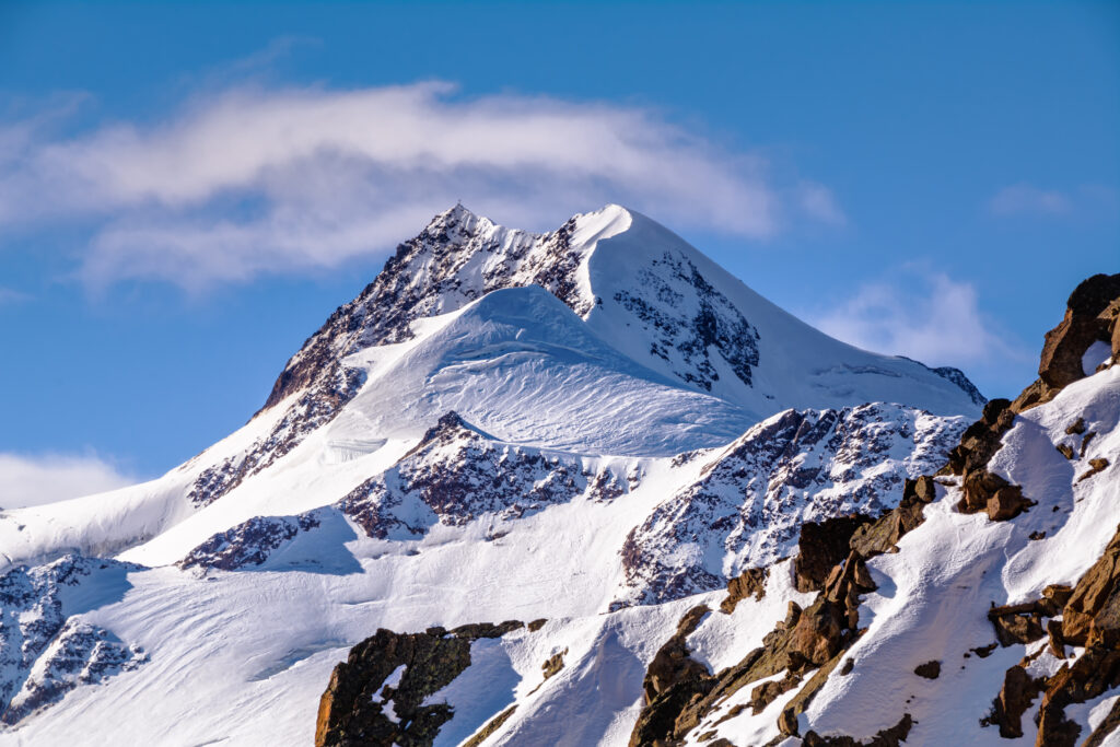
Wildspitze rises to 3,768 m (12,365 ft) above the Ötztal Alps as the highest peak in North Tyrol and the second highest mountain in Austria after Großglockner. Furthermore, the iconic glaciated summit anchors the Weißkamm ridge and ranks 4th in the entire Alps for prominence at 2,261 m.
However, the mountain offers more than statistics. Specifically, Wildspitze features twin summits — the higher rocky south summit and the firn-covered north summit. Additionally, the peak is surrounded by glaciers on three sides, including the impressive 8 km² Taschachferner glacier.
The first ascent dates to 1848 when Leander Klotz, a guide and farmer from the Rofen valley, summited with another local farmer. Moreover, the famous 50° north face has become a classic ice climbing objective. Subsequently, the peak earned recognition as one of the most accessible high glacier climbs in the Eastern Alps.
Despite its challenging glacier terrain, Wildspitze attracts thousands of climbers each summer through the Normal Route. Notably, the PD- grade makes it one of Austria’s most popular introductory glacier mountaineering objectives. Furthermore, the standard route from Breslauer Hütte covers manageable terrain for fit climbers with proper preparation.
This complete 2026 guide covers verified route descriptions, current hut booking requirements, gear lists, hazard analysis, seasonal timing, costs across budget tiers, expedition history, and essential safety protocols. Additionally, every detail reflects 2026 conditions confirmed through Austrian Alpine Club and IFMGA-certified guide service sources.
Live Wildspitze Operations Center
Real-time location intelligence and Breslauer Hütte weather conditions
Wildspitze stands as the crown jewel of the Ötztal Alps, rising 3,768 meters above the Weißkamm ridge as the highest peak in North Tyrol and second highest in Austria. Furthermore, the mountain anchors one of the most heavily glaciated regions in the Eastern Alps with the Taschachferner glacier covering 8 km².
However, the peak’s reputation extends beyond mere elevation. Specifically, Wildspitze ranks 4th in the entire Alps for prominence at 2,261 m, behind only Mont Blanc, Finsteraarhorn, and Großglockner. Subsequently, the dramatic 50° north face attracts ice climbers from across Europe.
The mountain features twin summits with a fascinating geological history. Moreover, the rocky south summit at 3,768 m now stands as the higher peak after the firn-covered north summit lost elevation due to glacier melt. Tragically, this transformation reflects broader climate impacts across Alpine regions.
Despite these challenges, Wildspitze remains one of Austria’s most popular glacier mountaineering objectives. Notably, the Normal Route from Breslauer Hütte grades PD- and provides excellent introduction to high-altitude glacier climbing. Most parties take 4 hours from the hut to the summit.
Wildspitze sits at the head of the Ötztal valley near Vent (1,900 m), accessible from Innsbruck via a 90-minute drive. Additionally, the mountain offers two main approach options through Vent on the east or Mittelberg in the Pitztal valley to the north. Furthermore, the Wildspitzbahn chairlift dramatically shortens the standard approach.
First climbed by Leander Klotz in 1848, the peak has since hosted countless first ascents and milestone climbs. Subsequently, the Klotz brothers guided the second ascent in 1857 with Joseph Anton Specht. Today, the Wildspitze ranks among the most frequently climbed mountains in the Alps.
The classic Vent-Breslauer Hütte-summit itinerary remains the recommended approach for most climbers. Specifically, this route offers PD- glacier mountaineering with a manageable summit day. Furthermore, the Breslauer Hütte at 2,844 m provides ideal acclimatization and authentic Alpine hut culture. Additionally, the route rewards fit climbers with one of Austria’s most spectacular summit panoramas.
The Taschachferner and surrounding glaciers contain extensive crevasse hazards. Specifically, climbers must travel as a roped party with proper crevasse rescue knowledge. Moreover, conditions deteriorate rapidly when icy snow exposes blue ice. Additionally, afternoon storms and whiteout conditions present serious navigation challenges. Therefore, early starts and conservative weather assessment are essential.
This guide consolidates information from the Austrian Alpine Club (ÖAV), German Alpine Club (DAV), Pitztaler Gletscher operators, IFMGA-certified guide services, the Rother Verlag “Hochtouren Ostalpen” guidebook, and verified expedition reports. Additionally, all elevations, route grades, costs, and hut booking requirements reflect 2026 conditions confirmed through April 2026.
At a Glance: Wildspitze Essentials
Wildspitze presents specific technical and logistical requirements. Furthermore, the following statistics summarize what climbers must prepare for. Specifically, every parameter below reflects 2026 conditions verified through Austrian Alpine Club and IFMGA guide service sources.
Eight Reasons Climbers Choose Wildspitze
Wildspitze holds a unique position in European mountaineering culture. Furthermore, the following reasons explain why thousands of climbers attempt this peak each summer. Importantly, each motivation also carries an associated responsibility for safe execution on glaciated terrain.
Austria’s Second Highest Peak
Wildspitze stands as the second highest mountain in Austria after Großglockner. Furthermore, the peak ranks first in the Ötztal Alps and North Tyrol, drawing climbers from across Europe.
Accessible PD- Glacier Climb
The Normal Route grades PD- making it ideal for first glacier mountaineering experience. However, climbers still need crampons, ice axe, harness, and rope skills throughout.
Spectacular 50° North Face
The classic 50-degree north face attracts experienced ice climbers from across the Alps. Subsequently, this route provides serious technical challenge for advanced alpinists.
Massive Taschachferner Glacier
At 8 km² the Taschachferner ranks among the largest glaciers in the Eastern Alps. Moreover, climbers experience true high-altitude glacier travel on the standard approach.
Twin Summit Traverse Option
Experienced parties can traverse from south summit to north summit along a narrow ridge. Additionally, this provides a complete tour of the peak’s twin character.
Excellent Hut Infrastructure
Breslauer Hütte (2,844 m) and Taschachhaus (2,434 m) provide quality Alpine hut accommodation. Furthermore, both huts offer authentic Tyrolean food and warm hospitality.
4th Highest Alps Prominence
With 2,261 m of topographic prominence, Wildspitze ranks 4th in the Alps behind only Mont Blanc, Finsteraarhorn, and Großglockner. Specifically, the views extend to the Großglockner and Finsteraarhorn.
Year-Round Climbing Options
Summer mountaineering combines with winter ski touring via the Pitztaler Gletscher lifts. Notably, this makes Wildspitze accessible across nearly the entire calendar year for prepared climbers.
Who Can Climb Wildspitze
Wildspitze suits a wide range of climbers but demands specific preparation. Specifically, the standard Normal Route requires solid glacier travel skills, crampon technique, and basic crevasse rescue knowledge. Furthermore, climbers should arrive with previous mountaineering experience or hire an IFMGA-certified guide.
The Normal Route gains approximately 924 m from Breslauer Hütte to the summit. Therefore, a climber who can comfortably handle 1,000 m elevation gain days at altitude has the engine for Wildspitze. However, raw fitness alone will not protect against glacier hazards or weather changes.
Beginners to glacier mountaineering should hire an IFMGA-certified guide for their first attempt. Subsequently, completing Wildspitze provides excellent preparation for harder Alpine objectives like Großglockner, Mont Blanc, or the Bernina group. Importantly, the manageable technical difficulty creates ideal learning conditions.
For the 50° north face ice climb, climbers need solid technical ice climbing skills with both axe placement and crampon technique. Moreover, the Taschachferner traverse from Braunschweiger Hut requires comfort with longer glacier days exceeding 6.5 hours of travel.
Most successful Wildspitze climbers complete prior glacier travel courses through DAV or ÖAV before attempting the peak. Notably, Austrian guides report that climbers with crevasse rescue training achieve significantly higher success rates. Furthermore, two-day itineraries with overnight at Breslauer Hütte produce better outcomes than single-day attempts. Therefore, invest in proper preparation before your trip.
Wildspitze in Eastern Alps Context
Wildspitze occupies a strategic position as the highest summit of the Ötztal Alps. Specifically, the peak ranks 2nd highest in Austria, just 30 m below Großglockner (3,798 m). Additionally, Wildspitze sits on the Weißkamm ridge that joins the main Alpine chain at the Weißkugel.
For climbers planning regional trips, Wildspitze pairs ideally with several nearby Ötztal Alps objectives. Furthermore, the Ortler in South Tyrol stands as the nearest higher mountain just 48.5 km south. Additionally, the Hohe Tauern range holds Großglockner as a logical next objective. Moreover, the Weißkugel (3,738 m) provides an excellent acclimatization peak.
Eastern Alps Companion Objectives
Wildspitze shares the Eastern Alps with several other classic 3,000-meter peaks. Furthermore, all six peaks below provide excellent training or progression objectives accessible from the same base regions.
Wildspitze History: From Schlagintweit to Modern Mountaineering
Wildspitze’s recorded history spans nearly 180 years and reflects significant chapters in Alpine mountaineering development. Ultimately, few peaks combine such striking glaciated character with extensive climbing pioneering. Specifically, the mountain played a foundational role in establishing Austrian Alpine club culture.
1847: First Recorded Attempt
The first recorded attempt on Wildspitze occurred in 1847 by brothers Hermann and Adolf Schlagintweit. Specifically, the German scientific explorers reached approximately 3,552 m on the northeast ridge. Additionally, they did not complete the ascent to either summit. Moreover, the Schlagintweit brothers later became famous for their extensive Himalayan expeditions.
1848: Klotz First Successful Ascent
The first successful ascent of Wildspitze was completed in 1848 by Leander Klotz, a guide and farmer from the Rofen valley (now part of Sölden). Specifically, Klotz climbed with another unnamed local farmer. Additionally, this party reached the south summit, which has since become the higher of the twin peaks. Furthermore, the Klotz family produced multiple generations of Wildspitze guides.
August 1857: Second Ascent with Specht
In August 1857, the brothers Nikodem, Leander, and Hans Klotz guided Joseph Anton Specht, a merchant from Vienna, to the summit. Moreover, this represented the second ascent and brought broader attention to the peak. Additionally, Specht’s account spread word of Wildspitze through Vienna’s mountaineering circles. Subsequently, more parties began arranging Klotz family guides for ascents.
August 29, 1861: First North Summit Ascent
On August 29, 1861, Nikodem and Leander Klotz guided Anthon von Ruthner and Friedrich von Enderes to the south summit. Specifically, during their hour-long stay, Leander traversed to the north peak. Additionally, this was considered the first ascent of the main summit at the time. Furthermore, the north summit was then measured at 3,776 m, higher than the south summit.
1905: Mass Climbing Era Begins
By summer 1905, contemporary reports describe many groups attempting Wildspitze from the Braunschweiger Hut. Specifically, this marked the transition from elite expeditions to popular mountaineering. Additionally, the construction of Alpine huts throughout the Ötztal made the peak accessible to broader climbing communities. Consequently, Wildspitze became one of the most frequently climbed peaks in the Eastern Alps.
20th Century: North Summit Decline
Throughout the 20th century, glacier melt steadily reduced the north summit’s elevation. Specifically, the north summit dropped from approximately 3,776 m to about 3,765 m by the 1990s. Additionally, this melting eventually rendered the south summit (3,768 m) the higher peak. Moreover, this transformation reflects broader climate impacts visible across the Ötztal Alps glaciers.
Modern Era: Cable Car Access
The Pitztaler Gletscher cable car system transformed access to Wildspitze in recent decades. Specifically, the Wildspitzbahn lift from Vent reaches 2,364 m, saving 1.5-2 hours of approach time. Additionally, the Pitztaler Gletscher Bahn from Mittelberg reaches 3,440 m at Café 3440. Furthermore, this infrastructure enables single-day ascents from the Pitztal side.
2020s: Climate Change Impact
Recent years have seen accelerating glacier retreat across the Ötztal Alps. Therefore, route conditions on Wildspitze have become increasingly variable each season. Additionally, the famous Café 3440 viewpoint on the Pitztaler Gletscher has documented dramatic glacier changes. Furthermore, climbers must now consult current conditions reports more frequently than in previous decades.
Climbing Routes on Wildspitze
Wildspitze features several established climbing routes across its glaciated aspects. Specifically, the Normal Route from Breslauer Hütte dominates climbing traffic. Furthermore, the Pitztal approach via Braunschweiger Hut, the technical 50° North Face, and various traverse options provide alternatives for experienced alpinists.
| Route | Approach | Grade | Distance | Time | Hut Base |
|---|---|---|---|---|---|
| Normal Route (Standard) | Vent | PD- | ~12 km RT | 4-6 hrs summit | Breslauer Hütte |
| Pitztal Approach | Mittelberg | PD- | ~10 km RT | 6.5 hrs RT | Braunschweiger |
| North Face (Ice) | Taschachferner | D / 50° | ~8 km RT | 8-10 hrs | Taschachhaus |
| Twin Summit Traverse | From south | PD+ | +30 min | +1 hr | Either |
Normal Route — Via Breslauer Hütte
The Normal Route from Vent represents the standard climbing approach on Wildspitze. Specifically, climbers begin from Vent at 1,900 m via the Wildspitzbahn chairlift to 2,364 m. Moreover, this saves 1.5-2 hours on the approach to Breslauer Hütte. Additionally, the lift operates daily from mid-June through late September.
From the chairlift top station, climbers follow a well-marked trail to Breslauer Hütte at 2,844 m. Specifically, this approach takes approximately 1.5 hours of moderate hiking. Additionally, climbers typically arrive in the afternoon for an early dinner and overnight rest. Furthermore, the hut serves traditional Tyrolean meals and offers warm dormitory accommodations.
Day two begins with a 3-4 am alpine start by headlamp. Subsequently, climbers descend slightly to the Mitterkar glacier and rope up. Additionally, the team crosses the Mitterkarferner to the Mittelkar Joch col. Furthermore, this section involves moderate glacier travel with occasional crevasse hazards.
From Mittelkar Joch, the route ascends approximately 750 m to the south ridge via roped glacier travel. Moreover, the final summit ridge involves easy UIAA Grade I rock scrambling for about 100 m. Notably, climbers stash skis (in winter) or trekking poles before the rocky summit pitch. Consequently, the Normal Route serves as the safest established Wildspitze ascent line.
Pitztal Glacier Approach — Via Mittelbergjoch
The Pitztal Glacier approach enables single-day ascents thanks to the Pitztaler Gletscher Express lift system. Specifically, the lifts reach 3,440 m at Café 3440, leaving only 700 m of climbing to the summit. Moreover, this represents the fastest possible Wildspitze ascent.
From Mittelbergjoch col, climbers descend to the Taschachferner glacier and rope up. Additionally, the route crosses crevasse-filled terrain to the Brochkogeljoch col. Furthermore, this approach was first used from the Braunschweiger Hut in 1905. Subsequently, the lift access has dramatically reduced approach times. The traverse also includes sections under impressive seracs requiring efficient travel.
North Face — 50° Classic Ice Climb
The North Face features 50 degrees of sustained ice climbing. Specifically, this route attracts experienced ice climbers from across the Alps. Additionally, the face requires technical ice tools, screws, and solid placement skills. Moreover, conditions vary dramatically with seasonal freeze-thaw cycles.
This route demands solid Alpine ice climbing experience at the D grade level. Furthermore, climbers approach from the Taschachhaus at 2,434 m. Additionally, the face provides one of the best ice climbing objectives in the Eastern Alps. Consequently, the North Face remains a coveted prize for technically capable Alpine climbers.
Twin Summit Traverse — South to North
The Twin Summit Traverse links the south summit (3,768 m) to the firn-covered north summit (3,765 m) via a narrow ridge. Specifically, this traverse adds about one hour to the summit experience. Additionally, the route was first completed during the 1861 ascent by Leander Klotz with von Ruthner and von Enderes.
The traverse stands as the complete Wildspitze experience. Furthermore, the narrow connecting ridge requires careful balance and rope management. Additionally, conditions vary based on snow cover and exposure. Consequently, the traverse represents the ideal Wildspitze project for experienced parties already comfortable with the Normal Route.
Wildspitze Access & Hut Bookings 2026
Wildspitze does not require any climbing permits or registration in 2026. However, hut accommodations require advance reservations during peak summer season. Specifically, Breslauer Hütte and Taschachhaus fill quickly during July and August weekends. Additionally, the German Alpine Club (DAV) and Austrian Alpine Club (ÖAV) manage most facilities.
Breslauer Hütte and Taschachhaus require advance booking 2-3 months in advance for peak July-August dates. Specifically, weekends fill first as Austrian and German climbers dominate weekend traffic. Additionally, DAV/ÖAV members receive significant discounts (typically 50% off non-member rates). Moreover, the Wildspitzbahn chairlift operates daily from mid-June through late September. Furthermore, the Pitztaler Gletscher lifts run year-round with seasonal schedules.
Required Reservations for 2026
- Breslauer Hütte: Advance booking through ÖAV — most popular Normal Route base
- Taschachhaus: DAV training center — alternative base for North Face routes
- Braunschweiger Hut: Pitztal approach base — book through ÖAV
- Vernagt Hütte: Würzburgerhaus alternative — useful for traverse trips
- DAV/ÖAV membership: Recommended for hut discounts (typically 50% off)
- Travel insurance: Recommended including mountain rescue coverage
- EHIC card: European Health Insurance Card for EU residents
Access Cost Breakdown
- Wildspitzbahn chairlift: EUR 25-35 round trip from Vent
- Pitztaler Gletscher lifts: EUR 50-60 from Mittelberg to 3,440 m
- Breslauer Hütte: EUR 30-50 per person dormitory + EUR 25-35 dinner
- DAV/ÖAV membership: approximately EUR 65 annually for adults
- Innsbruck Airport transfer: EUR 60-100 to Vent (90-minute drive)
- Public bus to Vent: EUR 15-25 from Ötztal Bahnhof train station
Access Logistics from Innsbruck
Wildspitze is accessible from Innsbruck Airport via a 90-minute drive west along the Inn valley. Specifically, climbers exit at the Imst-Pitztal junction for the Pitztal approach or continue to Ötz for the Vent approach. Additionally, public bus number 320 connects Ötztal Bahnhof to Vent every 30 minutes during summer. Moreover, rental cars provide the most flexible option for climbing trips. Consequently, plan to arrive in Vent by mid-afternoon for the hut approach.
Wildspitze Climbing Costs in 2026
Wildspitze climbing costs vary based on guide service level and route choice. Specifically, self-guided climbs run as low as EUR 200-400 covering hut fees and lifts. Furthermore, IFMGA-certified guided two-day ascents reach EUR 600-900 per person. Additionally, all costs reflect 2026 conditions verified through Austrian guide services.
Self-Guided Single-Day Pitztal Ascent
The cheapest path uses Pitztaler Gletscher lifts to 3,440 m and requires only the round-trip lift ticket and basic supplies. Furthermore, climbers with full personal gear and Pitztal valley basecamp can complete the ascent for under EUR 250. However, this approach assumes solid glacier travel skills and weather cooperation throughout.
Self-Guided Vent-Breslauer Hütte
Most international climbers budget for the classic two-day Vent approach. Additionally, costs include Breslauer Hütte overnight (EUR 50-80 with half board), Wildspitzbahn lift tickets (EUR 30), and travel from Innsbruck. Specifically, this tier represents the realistic cost for a well-planned independent attempt with proper acclimatization.
Two-Day Guided Normal Route
IFMGA-certified guides provide route-finding expertise, real-time hazard assessment, and emergency response capability. Furthermore, several Austrian services offer two-day Wildspitze climbs. Notably, guides typically maintain a 1:2 ratio on glacier terrain. Additionally, the price typically includes hut booking coordination but excludes personal gear.
Group Guided Climb (3-4 people)
Group climbs with 3-4 climbers per IFMGA guide significantly reduce per-person costs. Moreover, this option works well for friend groups or clubs. Subsequently, the lower price reflects shared guide costs while maintaining safety standards. Additionally, groups must demonstrate similar fitness and skill levels for safe ascent.
North Face Ice Climbing Guided
The 50° North Face requires specialist ice climbing instruction and 1:1 guide ratio. Furthermore, the price includes pre-trip skill assessment, gear coordination, and weather contingency days. Notably, this represents serious technical Alpine ice climbing requiring full ice climbing equipment. Consequently, the North Face suits only experienced ice climbers seeking an iconic Eastern Alps objective.
Essential Gear for Wildspitze
Gear requirements scale with route choice. Specifically, the standard Normal Route demands fundamentally different equipment than the technical North Face ice climb. Furthermore, glacier travel mandates specific equipment for safe crevasse rescue. Additionally, every essential item below reflects current IFMGA Austrian guide service recommendations.
Glacier Travel Gear (Mandatory)
- Mountaineering boots B2 or B3 with stiff sole
- 12-point mountaineering crampons
- Technical ice axe with adze, 60-65 cm length
- Climbing harness with adjustable leg loops
Rope & Rescue (Mandatory)
- 30-meter dynamic glacier rope (8.5-9 mm)
- Two locking carabiners minimum
- Two 120 cm dyneema slings
- Crevasse rescue kit (prussiks, pulley)
Helmet (Mandatory All Routes)
- Climbing-rated helmet, not bike helmet
- Petzl Boreo or Black Diamond Half Dome typical
- Rockfall hazard from summit ridge sections
- Required even on standard Normal Route
Pack and Hydration
- 30-liter daypack for summit attempts
- 3 liters water minimum, more in hot weather
- Insulated bottle prevents freezing on early starts
- Energy bars and quick lunch foods
Clothing System
- Synthetic or merino base layer, no cotton
- Insulating mid-layer fleece or light puffy
- Hardshell rain jacket and pants mandatory
- Warm hat, gloves (lightweight + warm pair)
Navigation and Safety
- Topographic map and compass for backup
- GPS device or smartphone with offline maps
- Headlamp with fresh batteries for early start
- Whistle, signaling mirror, satellite communicator
First Aid and Emergency
- Wilderness first aid kit suited to altitude injuries
- Emergency bivy sack or space blanket
- Athletic tape, blister treatment, ibuprofen
- InReach or similar two-way satellite messenger
North Face Additions
- Two technical ice tools with steep ice picks
- 10-12 ice screws (varied lengths 13-22 cm)
- 60-meter dynamic ice climbing rope
- Ice climbing helmet and chest harness
Hazards on Wildspitze
Wildspitze presents specific hazards typical of glaciated Alpine peaks. Specifically, crevasse hazards and weather changes account for most documented incidents on the mountain. Furthermore, climbers must assess each hazard category honestly before attempting any route on Wildspitze.
Crevasse Hazards on Glaciers
The Taschachferner and Mitterkar glaciers contain extensive crevasse fields. Specifically, snow bridges become unstable during warm weather and afternoon melt cycles. Furthermore, climbers must travel as roped parties throughout all glacier sections. Moreover, basic crevasse rescue knowledge represents an absolute prerequisite for the climb.
Whiteout and Visibility Issues
Mountain weather changes rapidly above 3,000 m on Wildspitze. Notably, summit visibility can drop to whiteout conditions within minutes. Additionally, navigation in poor visibility requires GPS skills and pre-planned bailout routes. Therefore, climbers should accept turnaround when visibility deteriorates significantly.
Afternoon Thunderstorms
Summer afternoon thunderstorms develop daily over the Ötztal Alps. Therefore, climbers must clear the upper mountain by midday and accept turnaround times. Notably, lightning strikes on exposed glaciated ridges remain a documented hazard across the Eastern Alps. Consequently, early starts at 3-4 am are essential.
Ice Climbing Hazards on North Face
The 50° North Face presents serious ice climbing hazards including rockfall, ice fall, and avalanche risk. Furthermore, conditions deteriorate rapidly with solar warming throughout the day. Subsequently, parties must complete the route quickly and avoid afternoon sun exposure on the face.
Glacier Retreat Variability
Climate change has dramatically affected Wildspitze glaciers in recent decades. Moreover, route conditions vary significantly year to year as glaciers retreat. Importantly, climbers must consult current conditions reports through ÖAV channels before attempting routes. Additionally, traditional approaches may require adjustment as glacier ice retreats.
Altitude and Acclimatization
The 3,768 m summit elevation can cause altitude effects in unacclimatized climbers. Furthermore, climbers arriving from sea level should plan one or two acclimatization days. Specifically, hiking to Breslauer Hütte the day before summit attempts helps significantly. Therefore, multi-day itineraries produce better outcomes than single-day attempts.
Safety Protocols for Wildspitze
Successful Wildspitze climbs depend on conservative decision-making and disciplined execution. Furthermore, the most experienced IFMGA guides emphasize that turning back is a victory when conditions deteriorate. Specifically, climbers should establish hard turnaround times and honor them regardless of summit proximity.
File a detailed itinerary with the Breslauer Hütte staff before starting. Additionally, carry a satellite communicator for emergency response in remote glacier terrain. Notably, Austrian Mountain Rescue (Bergrettung) coordinates rescue operations through the standard EU emergency number 112. Furthermore, knowing basic crevasse rescue and partner-rescue techniques can mean the difference between minor incidents and serious outcomes.
When to Climb Wildspitze
Seasonal timing on Wildspitze determines both safety and success rates. Specifically, the climbing window varies dramatically across summer and winter seasons. Furthermore, weather patterns and glacier conditions vary significantly each month, requiring careful attention to monthly conditions.
Spring (April to early June)
Late spring offers ski mountaineering season with the Pitztaler Gletscher lifts providing excellent access. Furthermore, the snow conditions on the glaciers are typically firm and stable. Specifically, ski tourers descend the 20-km Taschachtal valley with 2,000 m vertical descent.
Early Summer (Late June to July)
The Normal Route becomes climbable as summer access opens. Moreover, the Wildspitzbahn chairlift starts operating mid-June. However, fresh snow may still cover the upper mountain and occasionally limit access. Furthermore, daytime temperatures remain cool at altitude.
Peak Summer (July through August)
The most reliable weather window for Wildspitze attempts. Notably, climbers must still start by 3 am or 4 am to avoid afternoon thunderstorms. Subsequently, this period also brings the highest visitor pressure. Additionally, hut bookings fill 2-3 months in advance for July-August dates.
Early Fall (September to early October)
Stable high-pressure systems often bring excellent climbing weather through mid-September. Furthermore, crowds thin dramatically after the Wildspitzbahn chairlift closes around September 25. However, daylight shortens noticeably and early snowstorms can shut down access by mid-October.
Notable Expeditions and Climbs
Wildspitze’s climbing history features remarkable individual achievements alongside scientific expeditions. Furthermore, each notable ascent below contributed essential knowledge to modern Wildspitze climbing practice. Specifically, the expeditions span over 175 years of evolving Alpine mountaineering culture.
Schlagintweit First Attempt
Turnaround at 3,552 mBrothers Hermann and Adolf Schlagintweit made the first recorded attempt on Wildspitze. Specifically, they reached approximately 3,552 m on the northeast ridge before turning back. Furthermore, the brothers later became famous for extensive Himalayan scientific expeditions.
Klotz First Successful Ascent
First AscentLeander Klotz, a guide and farmer from Rofen valley, completed the first ascent with another local farmer. Specifically, the party reached the south summit. Additionally, the Klotz family became foundational to Wildspitze guiding for the next several generations.
Specht Second Ascent
SummitBrothers Nikodem, Leander, and Hans Klotz guided merchant Joseph Anton Specht from Vienna to the summit. Moreover, this brought broader attention to Wildspitze through Vienna’s mountaineering circles. Subsequently, more parties began arranging Klotz family guides.
First North Summit Ascent
First TraverseNikodem and Leander Klotz guided Anthon von Ruthner and Friedrich von Enderes to the south summit. Furthermore, Leander then traversed to the north peak during their hour-long stay. Additionally, this established the first traverse of both summits.
Mass Climbing Era
PopularizationBy summer 1905, contemporary reports describe many groups attempting Wildspitze from the Braunschweiger Hut. Specifically, this marked the transition from elite expeditions to popular mountaineering. Subsequently, Wildspitze became one of the most frequently climbed Eastern Alps peaks.
North Summit Glacier Decline
Glacier LossThe north summit dropped from approximately 3,776 m to about 3,765 m by the 1990s due to glacier melt. Moreover, this rendered the south summit (3,768 m) the higher peak. Additionally, this transformation reflects broader climate impacts visible across the Ötztal Alps.
Planning Your 2026 Wildspitze Climb
Successful Wildspitze planning combines logistics, training, and conditioning across multiple months. Furthermore, the following planning categories cover every essential element climbers must address. Additionally, each card represents a critical preparation area for any 2026 attempt.
Wildspitze Frequently Asked Questions
How tall is Wildspitze?
Wildspitze rises to 3,768 m (12,365 ft) at the south summit, the higher of two twin peaks. Specifically, it ranks as the highest mountain in the Ötztal Alps and second highest in Austria after Großglockner. Furthermore, the north summit at approximately 3,765 m was historically considered higher but lost elevation due to glacier melt. Additionally, with 2,261 m prominence, Wildspitze ranks 4th in the entire Alps behind only Mont Blanc, Finsteraarhorn, and Großglockner.
Do I need a permit to climb Wildspitze?
No formal climbing permits are required for Wildspitze in 2026. However, climbers should reserve hut accommodations well in advance through the German Alpine Club (DAV) or Austrian Alpine Club (ÖAV). Specifically, Breslauer Hütte and Taschachhaus require advance booking during peak summer season. Moreover, DAV/ÖAV members receive significant discounts (typically 50% off non-member rates).
How difficult is the Normal Route?
The Normal Route grades PD- (peu difficile minus) on the Alpine grading scale. Specifically, it requires glacier travel skills with crampons, ice axe, harness, and rope. Additionally, the summit ridge involves UIAA Grade I rock scrambling for approximately 100 m. Furthermore, the difficulty increases substantially when snow conditions become icy. Consequently, the route serves as one of Austria’s most popular introductory glacier mountaineering objectives.
Who first climbed Wildspitze?
Leander Klotz, a guide and farmer from Rofen valley, made the first successful ascent in 1848 with another local farmer. Specifically, this was the south summit. Furthermore, the north summit was first climbed on August 29, 1861 by Leander Klotz during a traverse from the south summit with Anthon von Ruthner and Friedrich von Enderes. Additionally, the first recorded attempt occurred in 1847 by brothers Hermann and Adolf Schlagintweit who reached approximately 3,552 m on the northeast ridge.
What is the best time to climb Wildspitze?
The optimal climbing season runs from late June through early September. Specifically, this window offers the most stable snow conditions and weather patterns. Additionally, ski mountaineering season extends from December through May using the Pitztaler Gletscher lifts. Furthermore, August typically provides the most reliable summer conditions. Moreover, climbers must start summit attempts at 3-4 am to avoid afternoon thunderstorms.
Where does the Normal Route start?
The standard route begins from Vent (1,900 m) in the Ötztal valley. Specifically, climbers ascend 944 m to Breslauer Hütte (2,844 m) on day one. Additionally, the Wildspitzbahn chairlift saves approximately 1.5-2 hours by lifting climbers to 2,364 m. Furthermore, the summit push from Breslauer Hütte typically takes 4 hours via the Mitterkar glacier. Consequently, most parties complete the climb as a two-day expedition.
How much does it cost to climb Wildspitze?
Self-guided climbs cost EUR 200-400 covering hut fees, lift tickets, and food. Furthermore, IFMGA-certified guided two-day ascents cost EUR 600-900 per person. Additionally, group rates with 2-4 climbers per guide reduce per-person costs significantly to EUR 400-600 per person. Moreover, equipment rental adds approximately EUR 50-80 per day. Specifically, the technical North Face guided climbs cost EUR 1,000-1,500 per person.
What gear do I need?
Essential equipment includes mountaineering boots (B2 or B3), 12-point crampons, ice axe, climbing harness, helmet, and 30 m glacier rope. Additionally, climbers need crevasse rescue equipment including prussiks and pulley. Furthermore, layered clothing, headlamp, sunglasses with side shields, and 3 liters water minimum are mandatory. Moreover, the technical North Face requires two ice tools, ice screws, and 60 m dynamic rope.
Is Wildspitze suitable for beginners?
Wildspitze suits beginners to glacier mountaineering with a guide. Specifically, the PD- grade represents an entry-level Alpine objective. Additionally, the manageable technical difficulty combined with high altitude makes it ideal for first 3,000 m glacier experience. However, glacier travel skills and crevasse rescue knowledge remain essential. Therefore, beginners should hire IFMGA-certified guides for their first attempt.
What other peaks can I combine with Wildspitze?
Wildspitze pairs well with several Ötztal Alps objectives. Specifically, Weißkugel (3,738 m) and Hintere Schwarze (3,628 m) provide nearby challenges. Additionally, the multi-day Ötztal Alps trek from Obergurgl to Vent offers excellent acclimatization. Furthermore, Großglockner (3,798 m) in the Hohe Tauern represents a logical next objective just 30 m higher. Moreover, Ortler (3,905 m) in South Tyrol stands as the nearest higher mountain at 48.5 km south.
Sources & Verified References
This Wildspitze climbing guide consolidates information from official Austrian and German Alpine Club publications, IFMGA-certified Austrian guide services, established European climbing resources, and verified expedition reports. Furthermore, every elevation, route grade, cost figure, and hut booking requirement reflects 2026 conditions confirmed through April 2026.
- Österreichischer Alpenverein (ÖAV) — Austrian Alpine Club hut bookings and route conditions
- Deutscher Alpenverein (DAV) — German Alpine Club Taschachhaus training center
- Pitztaler Gletscher Bahn — 2026 lift schedules and Glacier Express timetables
- Ötztal Tourism — Vent area accommodation and access information
- Bergführerverband — IFMGA-certified Austrian mountain guide services
- Rother Verlag “Hochtouren Ostalpen” — Detailed route descriptions and topographic maps
- SummitPost Wildspitze — Community-verified route reports and conditions
- ZAMG — Austrian Central Institution for Meteorology forecasts
- Bergrettung Österreich — Austrian mountain rescue service contact information
Related Alpine Climbing Guides
Plan Your 2026 Wildspitze Climb with Confidence
Get personalized route advice, current Ötztal Alps conditions reports, and connections to IFMGA-certified Austrian guides for your 2026 attempt. Furthermore, our planning specialists know every glacier crevasse field on the Normal Route.