
Last updated May 25, 2026
Climbing Grossvenediger 2026: Austria’s 4th-Highest Peak, the Kürsinger Hütte Normal Route & the Famous Summit Cross of the Hohe Tauern
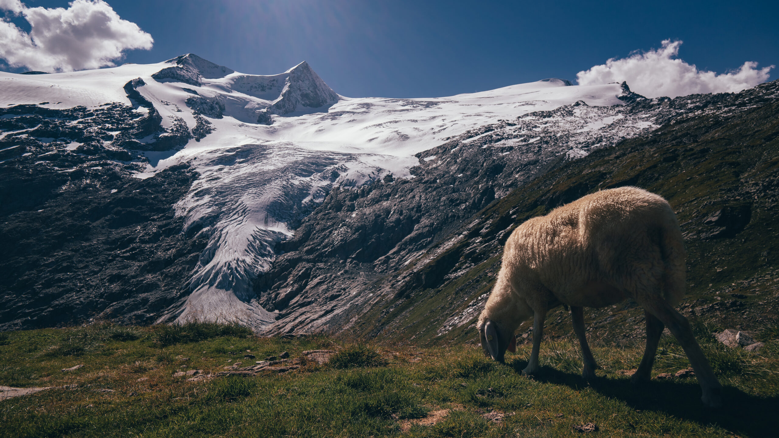
At 3,657 meters, Grossvenediger (Großvenediger) stands as Austria’s 4th-highest peak and the main summit of the Venediger Group in the Hohe Tauern range. The mountain is one of the most spectacular glaciated summits in the Eastern Alps — a peak where generations of mountaineers have climbed their first high glacier mountain. The famous Grossvenediger summit cross marks one of the most photographed mountain tops in Austria. The classic Kürsinger Hütte North Route, the 1841 first ascent by 26 climbers, the Schlaten-Kees glacier — the complete 2026 climbing guide.
Grossvenediger occupies a distinctive position in Austrian and European mountaineering. The peak isn’t the highest in Austria — Grossglockner claims that title at 3,798m, 141 meters taller. It isn’t even the highest in the Hohe Tauern range — Grossglockner takes that distinction as the High Tauern’s monarch. What Grossvenediger holds, definitively, is reputation as one of the most spectacular glaciated peaks in the entire Eastern Alps and the most accessible major glaciated summit in Austria. The mountain rises as a broad glaciated dome with extensive ice fields on all sides — the Obersulzbachkees, the Schlaten-Kees, and the Untersulzbachkees glaciers all flow from its slopes. For climbers building their first major glaciated mountain experience, Grossvenediger has served as the introductory peak for generations of Austrian, German, Italian, and international mountaineers.
The mountain stands on the border between East Tyrol and Salzburg in Austria’s Hohe Tauern range — the highest mountain range entirely within Austria. The peak is the main summit of the Venediger Group, with neighboring peaks including Keeskogel (3,291m), Grosser Geiger (3,360m), and various other glaciated summits forming the cluster. The Hohe Tauern National Park, established in 1981, protects 1,856 km² of alpine and glaciated terrain — Austria’s largest national park and one of Europe’s most significant alpine wilderness areas. Grossvenediger sits at the heart of this protected wilderness. The mountain is genuinely accessible. A road approaches from Neukirchen am Grossvenediger. A cable car (Kürsingerhütte cable car) eases the approach to 1,929m. Then the well-maintained Kürsinger Hütte at 2,547m provides comfortable high-camp accommodation. The summit cable car and hut system distinguish Grossvenediger from less accessible Alpine peaks.
The climbing itself sets Grossvenediger apart from harder Alpine objectives. All four normal routes are rated F (Facile) — the easiest grade in the French Alpine system. The routes are essentially glacier walks with relatively gentle terrain by Alpine peak standards. The climb requires basic alpine mountaineering competence: crampons, ice axe, rope team configuration for crevasse safety, and basic glacier travel skills. The famous Schlaten-Kees glacier provides the primary climbing surface, with all four normal routes converging at the “Bahnhof” (railway-station) col before the final summit climb. The relatively gentle terrain combined with the glacier environment makes Grossvenediger ideal for first-time alpine climbers building toward harder peaks. Many guides explicitly recommend Grossvenediger as preparation for Mont Blanc, the Matterhorn’s lower-difficulty routes, or other major Alpine objectives.
Find Hotels, Flights & Trips for the World’s Best Hiking Destinations
The Global Summit Guide Travel Shop on Expedia — curated for outdoor adventurers, mountaineers, and serious hikers. Patagonia to the Alps. Nepal to the Rockies. Curated lodging for every region we cover.
Explore Travel Shop on Expedia →This guide covers what you need to climb Grossvenediger in 2026. The classic North Route from Kürsinger Hütte in detail — the most popular of the four normal routes. The 1841 first ascent context — Grossvenediger climbed by an extraordinary 26-person party in one of the most ambitious early Alpine expeditions. The famous Grossvenediger summit cross — the iconic marker placed at the summit honoring the mountain’s climbing heritage. Mountain hut culture and Austrian Alpine Club (OeAV) member discounts. Ski mountaineering alternative for spring season. Costs, gear specifications, and operator pricing in EUR. And honest assessment of who should climb this peak. While Grossvenediger is among Austria’s most accessible major peaks, glacier travel competence and basic alpine experience matter. These skills meaningfully reduce risk and increase summit success.
Grossvenediger At a Glance
The essential reference facts for Grossvenediger. Detailed sections follow below.
| Summit elevation | 3,657 m (12,000 ft) — some sources cite 3,666 m by Adriatic datum |
|---|---|
| Native name | Großvenediger (German) |
| Location | Border between East Tyrol and Salzburg, Austria |
| Coordinates | 47.1083°N, 12.3458°E |
| Austria ranking | 4th highest peak in Austria (after Grossglockner, Wildspitze, Weisskugel) |
| Mountain range | Hohe Tauern (High Tauern), Venediger Group |
| National park | Hohe Tauern National Park — Austria’s largest (1,856 km²) |
| Distinctive feature | Main glaciated summit of the Venediger Group; “the most photographed glaciated dome in Austria” |
| Summit marker | Famous Grossvenediger summit cross — iconic mountain monument |
| First ascent | September 3, 1841 — 26-person party led by Josef Schwab and Prince-Bishop Joseph Bernhard von Spaur |
| Number of normal routes | 4 — all converging at the “Bahnhof” col before the summit |
| Standard route | North Route from Kürsinger Hütte — 4-4.5 hrs from hut |
| Standard grade | F (Facile) — easiest French Alpine grade |
| Approach | Neukirchen am Grossvenediger → Kürsingerhütte cable car (1,929 m) → Kürsinger Hütte (2,547 m) |
| Mountain huts | Kürsinger Hütte (2,547 m); Neue Prager Hütte; Defreggerhütte; Johannishütte |
| Famous glacier | Schlaten-Kees — the primary climbing glacier |
| Surrounding glaciers | Obersulzbachkees, Schlaten-Kees, Untersulzbachkees |
| Trip duration | 2 days with overnight at mountain hut typical; ski mountaineering also 2 days |
| Summit day length | 8-10 hours round trip from hut |
| Best summer season | Mid-June to mid-September (peak mid-July to August) |
| Best ski season | March through May for ski mountaineering ascents |
| Kürsinger Hütte cost | €60-€80/night with half-board (OeAV members 50% discount) |
| 2026 guided cost | €450-€1,200 per person depending on operator and program |
| Gateway towns | Neukirchen am Grossvenediger (Salzburg side); Matrei in Osttirol (Tyrol side) |
Why Grossvenediger is “the most accessible major glaciated peak in Austria”. Several factors combine to make Grossvenediger uniquely accessible among major Alpine peaks. First, the Kürsingerhütte cable car raises climbers from the valley floor at Neukirchen (920 m) to 1,929 m — eliminating much of the lower approach hike. Second, the well-maintained Kürsinger Hütte at 2,547 m provides comfortable overnight accommodation with the cable car system handling equipment transport. Third, all four normal routes are rated F (Facile) — among the easiest grades for any Alpine glaciated summit. Fourth, the gentle Schlaten-Kees glacier provides a relatively forgiving climbing surface compared to heavily crevassed glaciers on other peaks. Fifth, the route’s popularity means well-established trails, route markings, and predictable conditions. Generations of climbers have climbed Grossvenediger as their first high glacier mountain. The peak continues serving this role today. It remains one of the best introductory glaciated summits in the entire Alps.
Why Grossvenediger Matters in Alpine Mountaineering
Grossvenediger holds a precise position in European mountaineering culture. The mountain combines four distinguishing elements. First, status as Austria’s 4th-highest peak and the most accessible major glaciated summit. Second, iconic position as the introductory peak for generations of Alpine climbers. Third, the famous Grossvenediger summit cross as one of Austria’s most photographed mountain monuments. Finally, the dramatic glaciated setting within Hohe Tauern National Park. For climbers building toward harder Alpine objectives or seeking an authentic Austrian alpine experience, Grossvenediger delivers something genuinely distinctive.
The Famous Grossvenediger Summit Cross
The Grossvenediger summit cross stands as one of Austria’s most iconic mountain monuments. The cross was originally placed at the summit following the 1841 first ascent — a tradition continuing throughout Austrian Alpine mountaineering history that marks important summits with summit crosses (Gipfelkreuz). The current Grossvenediger summit cross has been maintained and replaced through the decades as weather and ice damage demanded, with the current iteration prominently visible on summit photographs. The cross has become one of the most photographed mountain monuments in Austria — appearing on countless climber summit photos, postcards, tourism marketing, and Alpine literature. Standing at the Grossvenediger summit cross represents a significant moment for Austrian and German climbers in particular, who associate the monument with the broader tradition of Austrian alpinism. The cross is visible from approaches during the final climb, providing visual confirmation of the summit goal during the ascent.
Austria’s Most Accessible Major Glaciated Summit
Grossvenediger is widely considered the most accessible major glaciated peak in Austria. The combination of factors creates conditions ideal for first-time alpine climbers. First, Kürsingerhütte cable car access. Second, comfortable mountain hut infrastructure. Third, F-grade climbing on all normal routes. Finally, the relatively gentle Schlaten-Kees glacier surface. Climbers building toward harder peaks benefit considerably. Many Austrian and German guide services explicitly position Grossvenediger as preparation for Mont Blanc, the Matterhorn, or other major Alpine objectives. The peak delivers a genuine major alpine summit experience. Features include extensive glacier travel, dramatic high-mountain environment, and serious altitude exposure at 3,657 m. However, the route lacks the technical climbing demands or extreme risks of harder peaks. For climbers experiencing their first 3,500m+ glaciated summit, Grossvenediger has been the standard choice for generations.
The 1841 First Ascent and Austrian Alpine Heritage
Grossvenediger was first climbed on September 3, 1841 by a remarkable 26-person party led by Josef Schwab and Prince-Bishop Joseph Bernhard von Spaur of Brixen. The expedition was extraordinary for its size and ambition — one of the largest first-ascent parties in Alpine history. The achievement came during the early period of organized Alpine mountaineering, before the famous “Golden Age of Alpinism” (1854-1865) when British climbers dominated first-ascent activity. The 1841 ascent established Grossvenediger as a significant peak in early Austrian alpine tradition. The mountain became deeply embedded in Austrian climbing culture. The Austrian Alpine Club (Österreichischer Alpenverein, OeAV) was founded in 1862, just 21 years after the first ascent. The club developed the rifugio system and route infrastructure that supports modern climbing.
The Hohe Tauern National Park Setting
Grossvenediger sits at the heart of Hohe Tauern National Park — Austria’s largest national park, established in 1981, covering 1,856 km² across Salzburg, Carinthia, and Tyrol. The park protects extensive alpine and glaciated terrain including Grossvenediger and Austria’s highest peak Grossglockner. The protected status preserves the wilderness character of the Venediger Group while supporting sustainable mountaineering tourism. The park’s broader ecological significance includes major glacier systems, alpine meadows, and habitat for ibex, chamois, golden eagles, and other Alpine wildlife. Climbers approaching Grossvenediger experience not just a mountain but a major European wilderness area. The national park status also coordinates with Austrian Alpine Club rifugio management, creating an integrated framework for both wilderness protection and climbing access.
The Schlaten-Kees glacier — Grossvenediger’s primary climbing surface. The Schlaten-Kees is the primary climbing glacier on Grossvenediger (“Kees” is the local Austrian/Tyrolean word for glacier). The Schlaten-Kees reaches up to the summit ridge and provides a technically very easy ascent by foot or with skis — making the peak accessible to first-time alpine climbers. However, the glacier has crevasses, particularly in the middle and upper sections, so rope team travel is mandatory. All four normal routes converge at the so-called “Bahnhof” (German for “railway station”) col at the upper edge of the Schlaten-Kees, just below the final summit climb. The Bahnhof name reflects the historical traffic of climbers from multiple approach valleys all converging at the same point. During peak season the Bahnhof can become genuinely crowded with parties from different huts meeting before the final summit push. The Schlaten-Kees has retreated significantly due to climate change over recent decades. The retreat exposes more rock and changes route conditions year by year. Climbers should verify current glacier conditions through hut wardens before attempting.
Who Should Climb Grossvenediger?
Grossvenediger sits at a specific position in Alpine mountaineering progression. The peak is accessible for first-time alpine climbers with appropriate preparation but rewards experience with greater success and safety. Honest pre-trip self-assessment matters, particularly regarding glacier travel competence and basic crampon technique.
Grossvenediger Is Appropriate For:
First-time alpine climbers with a guide. Grossvenediger is widely considered one of the best introductory glaciated peaks in the Alps. Climbers without prior alpine experience can attempt the peak successfully with an IFMGA-certified guide. The F-grade climbing, well-maintained route, and comfortable hut infrastructure all support first-time alpine attempts.
Climbers with basic crampon experience. Even basic crampon experience helps — climbers who’ve used crampons on simple glaciated terrain or done basic mountaineering courses have the foundation. The route doesn’t demand advanced technical skills but does require comfort with crampon-equipped glacier travel.
Climbers preparing for Mont Blanc. Grossvenediger provides ideal preparation for Mont Blanc and similar major Alpine objectives. The combination of glacier travel, altitude exposure, and rope team work directly transfers to harder peaks. Many Austrian and German operators explicitly position Grossvenediger as Mont Blanc preparation.
Ski mountaineers. Grossvenediger is one of Austria’s premier ski mountaineering destinations during March-May season. The wide, relatively gentle Schlaten-Kees provides excellent ski touring terrain. Many Austrian ski mountaineers consider Grossvenediger essential training for harder Alpine ski objectives.
Climbers seeking Austrian Alpine culture. Austrian Alpine Club (OeAV) hut culture, Tyrolean mountain hospitality, and the broader Austrian Alpine tradition all differ from Swiss or French Alpine experience. Climbers interested in Austrian Alpine culture find Grossvenediger ideal.
Patient hut-based climbers. The standard 2-day program (cable car → hut → summit attempt → descent) demands a brief overnight commitment. Climbers comfortable with mountain hut culture (shared dormitory bunks, half-board meals, simple facilities) have the foundation.
Grossvenediger Is Not Appropriate For:
Climbers without any crampon experience or training. Even though the climb is glacier walking, basic crampon technique is essential. Climbers without any prior crampon use or basic mountaineering courses should take a glacier course before attempting.
Climbers expecting trail walking. Grossvenediger is glacier mountaineering, not hiking. Climbers expecting marked trails throughout shouldn’t attempt the peak — the upper route demands glacier travel with rope team and crampons.
Climbers seeking pure rock climbing. The standard routes are glacier walks, not rock climbing. Climbers wanting technical rock climbing should consider the West Ridge (UIAA III) or look at other peaks. The standard route doesn’t deliver rock climbing content.
Climbers without basic high-altitude tolerance. 3,657m is meaningful altitude. Climbers without any prior exposure above 3,000m should build experience on easier peaks first.
Solo first-time climbers. Solo climbing Grossvenediger as a first alpine peak is genuinely dangerous due to crevasse hazards. First-time climbers should always attempt the route with experienced partners or a guide.
Where Grossvenediger Fits in Your Alpine Progression
| Stage | Peak / Experience | Difficulty | What it builds |
|---|---|---|---|
| Foundation | Italian Dolomites via ferrate, Tyrolean hut hikes | Hiking / via ferrata | Mountain fitness; basic Alpine environment exposure |
| First glacier exposure | Basic glacier courses, simple glaciated peaks | F / Easy | Crampon technique; rope team basics; crevasse awareness |
| Grossvenediger step | Grossvenediger via North Route (Kürsinger Hütte) | F / Facile | Major glaciated summit; sustained glacier travel; altitude exposure |
| Mont Blanc preparation | Monte Rosa Dufourspitze, Gran Paradiso, Allalin | F+ to PD | Higher altitude glacier travel; more sustained routes |
| Mont Blanc summit | Mont Blanc (Gouter or Trois Monts route) | PD to PD+ | The major 4,000m+ Alpine objective |
| Technical 4,000m peaks | Matterhorn Hornli Ridge, Eiger Mittellegi | AD+ to D | Sustained technical climbing at altitude |
| Hard Alpine peaks | Eiger North Face, Grandes Jorasses | D+ to ED | Elite alpine climbing |
| Grossvenediger as preparation peak | Used by many for Mont Blanc / Matterhorn training | F | Returns through this stage frequently |
The Standard Routes Up Grossvenediger
Four normal routes exist on Grossvenediger, all rated F (Facile) and all converging at the famous “Bahnhof” col before the final summit climb. The North Route from Kürsinger Hütte is the most popular. Three additional normal routes approach from other huts. Two technical routes (West Ridge and North Ridge) provide harder alternatives for experienced alpinists.
| Route | Side | Difficulty | Hut to summit time | Usage |
|---|---|---|---|---|
| North Route (Kürsinger Hütte) — Standard | North | F / Facile | 4-4.5 hrs | ~60% of climbers |
| East Route (Neue Prager Hütte) | East | F / Facile | 3-3.5 hrs | ~20% of climbers |
| Southeast Route (Badener Hütte) | Southeast | F / Facile | 5 hrs | ~10% of climbers |
| South Route (Defreggerhütte) | South | F / Facile | 2.5 hrs | ~5% of climbers |
| West Ridge (technical) | West | UIAA II-III | 4.5 hrs | ~3% of climbers |
| North Ridge (technical) | North | UIAA III+ | 6 hrs | ~2% of climbers |
Route 1: North Route from Kürsinger Hütte (Standard — 60% of climbers)
The North Route from the Kürsinger Hütte is the most popular climbing line on Grossvenediger. The route ascends from the hut at 2,547m via the Obersulzbachkees glacier. It traverses to the Schlaten-Kees and joins three other normal routes at the famous “Bahnhof” col. From there the final climb reaches the summit at 3,657m. Total summit day from the hut runs 4-4.5 hours up plus descent — typically 8-10 hours round trip. The route is essentially a long glacier walk with relatively gentle terrain and modest objective hazards from crevasses on the Schlaten-Kees.
The Full Route Progression
- Day 1 — Approach to Kürsinger Hütte (2,547m): Meet at Neukirchen am Grossvenediger. Drive or taxi to the Kürsingerhütte cable car valley station. The cable car raises climbers to 1,929m and transports heavy equipment to the hut by cable. From the cable car top station, hike approximately 1.5-2 hours to Kürsinger Hütte via either the normal path or the Klamml via ferrata route. Most parties arrive at the hut mid-afternoon, settle into bunk dormitories, eat early dinner (typically 18:00-19:00 Austrian Alpine Club style), and prepare for the early morning summit attempt.
- Kürsinger Hütte (2,547m): Austrian Alpine Club (OeAV) hut providing bunk room accommodation with half-board (dinner and breakfast). The hut features no reception or WiFi — it remains genuinely traditional in operation. OeAV members receive significant discounts. The hut hosts climbers attempting Grossvenediger plus the neighboring Keeskogel and other Venediger Group peaks. Reservations essential during peak season (July-August).
- Day 2 — Pre-dawn summit day departure: Most parties leave Kürsinger Hütte between 04:00 and 05:00. Headlamps essential. Cool temperatures even in summer at 2,547m. Quick breakfast in the hut dining room.
- Approach to glacier (2,547-2,800m): The first hour of climbing involves moraine and approach terrain before reaching the glacier edge. Crampons donned at the glacier transition. Rope team configuration established for crevasse safety.
- Obersulzbachkees traverse (2,800-3,200m): The route crosses the Obersulzbachkees glacier with steady ascending traverse. Crevasses become a meaningful factor — rope team essential. Multiple variations exist depending on snow conditions and crevasse evolution.
- Transition to Schlaten-Kees (3,200-3,400m): The route transitions from the Obersulzbachkees to the larger Schlaten-Kees glacier. The Schlaten-Kees is the primary climbing glacier and reaches up to the summit ridge.
- The “Bahnhof” col (3,400-3,500m): All four normal routes converge at the so-called “Bahnhof” (railway station) col at the upper edge of the Schlaten-Kees. The name reflects the historical traffic of climbers from multiple approach valleys all meeting at the same point. During peak season the Bahnhof can become crowded.
- Final summit climb (3,500-3,657m): From the Bahnhof, the final 150 vertical meters climbs to the summit. Relatively gentle terrain by Alpine standards but still demands sustained focus at altitude.
- Summit at 3,657m — Grossvenediger Summit Cross: The famous Grossvenediger summit cross stands at the top — Austria’s iconic mountain monument. Extraordinary 360-degree panorama — Grossglockner to the east, Stubai Alps to the west, Ortler in Italy visible on clear days, the Ziller Alps to the north. Stay 30-45 minutes for photos and summit cross visits.
- Descent (summit back to hut): Reverse the route. The descent is straightforward but tiring after the morning ascent. Watch for soft snow conditions on the glacier as day temperatures rise. Return to Kürsinger Hütte typically by 12:00-14:00. Total summit day: 8-10 hours.
- Return to valley: Descend from Kürsinger Hütte back to the cable car station, then return to Neukirchen am Grossvenediger via cable car and shuttle. Most parties complete the descent same day as the summit.
Strengths
- Most accessible major glaciated Austrian peak
- Famous Grossvenediger summit cross experience
- Kürsingerhütte cable car eases approach
- Austrian Alpine Club hut culture
- Ideal Mont Blanc preparation peak
- Extensive glacier travel experience
Considerations
- Crevasse hazards demand rope team competence
- 2-day program commitment
- “Bahnhof” col can be crowded peak season
- Schlaten-Kees retreat creates changing conditions
- German-language environment at hut
- Cable car / hut booking required ahead
Route 2: East Route from Neue Prager Hütte (20% of climbers)
The East Route from the Neue Prager Hütte is the second most popular normal route on Grossvenediger. The hut at approximately 2,782m is accessed from Matrei in Osttirol via the Felbertauern Road and Matreier Tauernhaus parking. The route is the shortest from hut to summit at 3-3.5 hours and is favored by climbers preferring quicker summit attempts and the Tyrolean approach. The route joins the standard North Route at the Bahnhof col before the final summit climb. The Neue Prager Hütte is more remote and less frequented than the Kürsinger Hütte but provides a high-quality Austrian Alpine Club experience. Many Tyrolean climbers prefer this route for its shorter summit day and quieter ascent line.
Route 3: West Ridge (Technical Alternative — 3% of climbers)
The West Ridge offers a more technical alternative to the standard normal routes. The ridge is peppered with varied sections where climbers are mostly alone — avoiding the crowds of the normal route to the west. The climb features UIAA III rock at the approach to the ridge, then UIAA II at the ridge itself. The ridge is reached at approximately 3,458m at the “Westgrat-Schartl” — typically requiring some ice climbing during the approach. The route climbs over easy block terrain from the “white tooth” feature to the summit. The West Ridge appeals to climbers seeking technical variety beyond the standard glacier walk, while still providing summit success in the same 4.5-hour timeframe. Adventure Sports (Tauern Sports) and similar Austrian guide services offer this route for experienced alpinists. The route requires roped climbing competence, basic rock protection skills, and comfort with mixed climbing terrain.
Grossvenediger Climbing History: From 1841 to 2026
The Grossvenediger region has been part of Tyrolean and Salzburg cultural heritage for centuries. The Hohe Tauern range was crossed by salt trade routes between the Salzburg salt mines and southern Tyrol from medieval times. The mountain’s distinctive name “Großvenediger” relates to the Venetian-Tyrolean trade history, though the exact etymology is debated. Local Tyrolean dialect references the peak as “Venezianer” (Venetian) — reflecting the historical trade connections across the mountain pass routes. The mountain’s prominent profile made it a recognizable landmark for trade caravans and early Tyrolean travelers across the centuries.
Through the 1820s and 1830s, multiple attempts were made on Grossvenediger by Tyrolean and Salzburg climbers. The mountain was widely considered impossible to climb due to its extensive glaciation and the perceived dangers of crevasse travel. Local guides made initial reconnaissance attempts but consistently turned back due to weather, glacier conditions, or assessment of the dangers. The peak remained unclimbed despite increasing interest from Austrian Alpine pioneers during this era.
The first ascent of Grossvenediger was completed on September 3, 1841 by an extraordinary 26-person party led by Josef Schwab and Prince-Bishop Joseph Bernhard von Spaur of Brixen. The expedition was remarkable for its size and ambition — one of the largest first-ascent parties in Alpine history. The party included Salzburg and Tyrolean alpine pioneers, scientists, and local guides. The success established Grossvenediger as a significant peak in early Austrian alpine tradition. The first ascent came before the famous “Golden Age of Alpinism” (1854-1865), when British climbers dominated Alpine first ascents. The timing made Grossvenediger one of the earlier major Alpine peaks successfully climbed by an organized party.
The Österreichischer Alpenverein (OeAV) — Austrian Alpine Club — was founded in 1862, just 21 years after the Grossvenediger first ascent. The OeAV became central to Austrian alpine culture, eventually growing to become one of the world’s largest mountaineering organizations with hundreds of thousands of members. The Austrian Alpine Club established the hut system that supports modern Grossvenediger climbing, with the Kürsinger Hütte, Neue Prager Hütte, Defreggerhütte, and Johannishütte all eventually built and maintained by the club. The OeAV continues operating today with extensive rifugio infrastructure across the Austrian Alps.
The late 19th century saw the construction of the mountain huts that support modern Grossvenediger climbing. The Kürsinger Hütte was originally built in 1877 (with subsequent rebuilds and expansions). The Neue Prager Hütte (originally established as the Prager Hütte) was built during this era. The Defreggerhütte and Johannishütte similarly date from this period. The huts transformed Grossvenediger climbing from week-long expeditions to standard 2-3 day programs. Austrian Alpine Club sections from Vienna, Salzburg, and other cities sponsored individual hut construction — creating the infrastructure that continues supporting climbing today.
Through the early 20th century, Grossvenediger became firmly established as one of Austria’s premier climbing peaks. The 1841 first-ascent route became the standard “Normal Route” via Kürsinger Hütte. The technical West Ridge and North Ridge routes were established by experienced alpinists seeking harder objectives. World Wars I and II interrupted Austrian Alpine climbing significantly. The post-war reconstruction era saw renewed interest in the peak, with returning Austrian and German climbers re-establishing climbing traditions. The Austrian Alpine Club rebuilt damaged huts and expanded the route infrastructure.
The construction of the Kürsingerhütte cable car (Kürsingerhütteseilbahn) in the post-war era transformed Grossvenediger access. The cable car raised climbers from the valley floor at 920m to 1,929m — eliminating much of the lower approach hike and making the peak dramatically more accessible. Annual climbing numbers grew significantly. Grossvenediger became established as “the most accessible major glaciated peak in Austria” — a reputation that persists today. The cable car infrastructure also enabled equipment transport to the Kürsinger Hütte, simplifying logistics for climbers.
Austria established the Hohe Tauern National Park in 1981 (with subsequent expansions), creating the country’s largest national park covering 1,856 km² across Salzburg, Carinthia, and Tyrol. The park protects extensive alpine and glaciated terrain including Grossvenediger and Austria’s highest peak Grossglockner. The protected status preserved the wilderness character of the Venediger Group while supporting sustainable mountaineering tourism. The park designation enhanced ecological protection without restricting climbing access — climbing remained permitted within the broader recreation framework. Hohe Tauern National Park status added Grossvenediger to a list of European peaks within UNESCO-quality protected areas.
The 1990s and 2000s saw systematic commercial guiding develop on Grossvenediger. IFMGA-certified Austrian guides established programs targeting both domestic Austrian climbers and international visitors. International operators added Grossvenediger to portfolios as Mont Blanc preparation peak. The Austrian Alpine Club hut system was modernized while maintaining traditional alpine character. Annual climbing traffic grew significantly. The mountain became established as one of Europe’s premier introductory glaciated peaks, with climbers from Germany, Italy, Netherlands, and increasingly from English-speaking countries.
The 2010s brought visible impacts of climate change to Grossvenediger and the Venediger Group. The Schlaten-Kees, Obersulzbachkees, and Untersulzbachkees glaciers retreated significantly through the decade. Glacier surface elevations dropped meaningfully. Some former ice climbing routes on the northeast face lost their ice character. Route conditions year-to-year became less predictable. Crevasse patterns evolved as glaciers thinned. The Hohe Tauern National Park and Austrian Alpine Club implemented monitoring programs tracking glacier changes. Climbers approaching the mountain in modern conditions face evolving route conditions that differ from older guidebook descriptions.
The COVID-19 pandemic affected Grossvenediger climbing significantly during 2020 with Austrian travel restrictions. The 2021 and 2022 seasons saw progressive return to typical climbing activity as European travel patterns normalized. Austrian Alpine Club huts implemented health protocols including capacity management and pre-booking systems. The Kürsinger Hütte continued operating throughout the pandemic with adapted protocols. Post-pandemic climbing returned to typical levels by 2022, with the established booking systems remaining as ongoing operational improvements.
The 2023-2025 climbing seasons saw continued strong demand for Grossvenediger among Austrian, German, and international climbers. IFMGA Austrian guide services run regular programs throughout the summer season. International operators continue offering Grossvenediger as Mont Blanc preparation. The Kürsinger Hütte operates at capacity during peak weeks — reservations essential 2-3 months ahead for July/August dates. 2026 climbing season is currently active with the late June through mid-September window. Austrian Alpine Club discounts continue, with reciprocal arrangements for international Alpine Club members making the peak particularly accessible. Glacier retreat continues affecting route conditions but the mountain remains genuinely climbable with appropriate preparation.
The Austrian Alpine Heritage: OeAV Hut System and Grossvenediger
Grossvenediger occupies a specific position in Austrian Alpine Club (OeAV) culture and heritage. Understanding the Austrian Alpine context shapes how serious climbers approach the peak within broader European Alpine traditions.
The Austrian Alpine Club (Österreichischer Alpenverein)
The Österreichischer Alpenverein (OeAV) was founded in 1862 in Vienna, just 21 years after the Grossvenediger first ascent. The club has grown to become one of the world’s largest mountaineering organizations, with over 700,000 members and operating approximately 230 mountain huts across the Austrian Alps. The OeAV established the rifugio system that supports modern Austrian Alpine climbing — including the Kürsinger Hütte, Neue Prager Hütte, Defreggerhütte, and Johannishütte that serve as bases for Grossvenediger ascents. The club continues actively maintaining huts, marking routes, conducting glacier monitoring, and supporting Austrian Alpine education. International climbers benefit significantly from OeAV membership and from reciprocal arrangements with other Alpine clubs.
The Four OeAV Huts for Grossvenediger
| Hut | Elevation | Side | Notable Features |
|---|---|---|---|
| Kürsinger Hütte | 2,547 m | North | Standard route; Kürsingerhütte cable car eases approach; most popular hut |
| Neue Prager Hütte | 2,782 m | East | Shortest summit day (3-3.5 hrs); accessed from Matrei in Osttirol |
| Defreggerhütte | 2,962 m | South | Highest of the four huts; shortest summit day at 2.5 hrs |
| Johannishütte | 2,121 m | South | Lower hut; used by parties preferring longer approach |
OeAV Membership and Reciprocal Arrangements
Austrian Alpine Club (OeAV) membership offers significant value for climbers planning Grossvenediger and broader Austrian Alpine climbing. Annual OeAV membership costs approximately €60-€80 per year, with the membership paying for itself within one trip through hut discounts of approximately 50% on overnight rates. International climbers benefit from reciprocal arrangements. Alpine Club London, American Alpine Club, German Alpine Club (DAV), Swiss Alpine Club (SAC), and other major Alpine clubs all have agreements with OeAV. These grant member-rate access to OeAV huts. The DAV (German Alpine Club) actually shares the same hut network with OeAV under joint management. Climbers planning multi-day Austrian Alpine trips should join a reciprocal club well before their trip — the savings on a 2-3 night Grossvenediger trip alone justify membership costs.
The “Bahnhof” col — where all four normal routes converge. The “Bahnhof” col (German for “railway station”) is the famous convergence point on Grossvenediger where all four normal routes meet before the final summit climb. The col sits at approximately 3,400-3,500m at the upper edge of the Schlaten-Kees glacier. The name reflects the historical traffic of climbers from multiple approach valleys all converging at the same point — like trains arriving at a railway station. During peak season weekends in July and August, the Bahnhof can become genuinely crowded with parties from the Kürsinger Hütte, Neue Prager Hütte, Defreggerhütte, and Johannishütte all meeting at the same time. The crowding adds social character to the climbing experience but can also create pace bottlenecks on the final summit climb. Many experienced climbers time their summit attempts to either lead the morning crowd or trail behind the main groups to avoid the Bahnhof congestion. Photos of the Bahnhof during peak weekends show genuinely considerable traffic — a uniquely Austrian Alpine climbing experience.
Grossvenediger Summit Day Timeline: Hour-by-Hour from Kürsinger Hütte
Summit day on Grossvenediger typically runs 8-10 hours round trip from Kürsinger Hütte (2,547m) to the summit at 3,657m and back. Strong, well-conditioned teams complete the round trip in 7-9 hours. Slower parties may take 10-12 hours. The relatively gentle terrain by Alpine standards combined with glacier travel and altitude makes this a meaningful but achievable summit day for prepared climbers.
Standard Grossvenediger Summit Day — Kürsinger Hütte (2,547m) to Summit (3,657m) and Return
Which Grossvenediger Approach Fits Your Situation?
The choice on Grossvenediger involves route selection, operator decision, season choice, and program structure. Use this matrix to match yourself.
Match Yourself to a Grossvenediger Approach
When to Climb Grossvenediger: Season-by-Season Analysis
Mid-July to Mid-August: Peak Summer Season
The prime Grossvenediger summer climbing window. The glacier is in its summer condition, the Kürsinger Hütte and other huts operate at full capacity, and trail conditions are excellent. Trade-off: hut crowds peak during weekend days — weekday attempts offer significantly fewer climbers. The Bahnhof col can become crowded during peak weekends. Most successful Grossvenediger summits occur during this window. Weather is generally most stable, though afternoon thunderstorms remain possible.
Late August to Mid-September: Sweet Spot
Many experienced climbers consider this the optimal Grossvenediger window. Conditions remain excellent with somewhat less afternoon weather instability. Crowds drop noticeably from peak summer. Hut reservations easier to obtain. Daylight remains adequate for the long summit day. Photography conditions are excellent with stable late-summer alpenglow on the famous summit cross.
Late September to Early October: Autumn Window
The autumn window brings stable weather, golden larch colors in the lower approach valleys, and significantly reduced crowds. Temperatures drop noticeably — start with warmer layers than summer. Early October may bring first snow that creates winter-style conditions. The Kürsinger Hütte and other huts typically close for the season in late September depending on weather. Climbers attempting after hut closure must use bivouac shelters.
March-May: Ski Mountaineering Season
Grossvenediger is one of Austria’s premier ski mountaineering destinations. The wide, relatively gentle Schlaten-Kees provides excellent ski touring terrain. Many Austrian ski mountaineers consider Grossvenediger essential training for harder Alpine ski objectives. The same hut infrastructure operates with ski-specific access patterns. The Kürsingerhütte cable car may operate on different schedules during ski season — verify with the operator before booking. Ski mountaineering ascents typically run March through May depending on snow conditions.
Late June to Early July: Early Summer
Early July can have remnant snow on the upper glacier sections, with conditions transitioning from ski season to summer climbing. Snow bridges over crevasses are typically stronger early in the season. The Kürsinger Hütte typically opens mid-June. Daylight is at its longest — useful for the long summit day. Conditions can vary year-to-year depending on winter snowfall and spring melt patterns.
October-February: Off-Season
Winter Grossvenediger ascents become serious ski mountaineering objectives requiring full winter experience. The Kürsinger Hütte closes for the season. Avalanche risk in the Venediger Group is genuine throughout winter. Some experienced ski mountaineers approach Grossvenediger during stable winter conditions, but the climbing demands different equipment and skills from summer ascents.
Climbing Grossvenediger in 2026: Cost Breakdown (EUR)
Grossvenediger offers strong value among Alpine climbing destinations. Austrian Alpine Club hut pricing combined with the accessible approach keeps total costs affordable compared to peers like Mont Blanc or the Matterhorn. The cable car system reduces effort and trip duration.
2026 Guided Expedition Pricing
| Operator Tier | 2026 Cost (EUR) | What’s Included |
|---|---|---|
| Austrian IFMGA guide (1-day) | €300-€450 per person | Single-day guided ascent; suitable for climbers near the area; 2-3 climbers per guide |
| Austrian IFMGA guide (2-day) | €450-€700 per person | Standard 2-day program with Kürsinger Hütte overnight; most common choice |
| Private 1:1 or 1:2 guiding | €800-€1,200 per person | Dedicated guide attention, custom dates, flexible itinerary |
| West Ridge technical (guided) | €700-€1,100 per person | UIAA II-III technical route; experienced alpinist programs |
| Ski mountaineering ascent (2-day) | €450-€700 per person | March-May ski touring program; similar to summer pricing |
| Mont Blanc preparation course (5-7 day) | €1,200-€2,000 per person | Multi-peak program with Grossvenediger as preparation; combined with other Alpine objectives |
2026 Independent Trip Cost Breakdown
| Cost Component | 2026 Amount (EUR) | Notes |
|---|---|---|
| Kürsingerhütte cable car (round trip) | €15-€25 | Per person; equipment transport included |
| Kürsinger Hütte (1 night) | €60-€80 | Half-board (bed, dinner, breakfast); OeAV/DAV members 50% discount |
| Hut additional nights | €60-€80/night | For weather flexibility or post-summit recovery |
| Neukirchen accommodation | €60-€120/night | B&Bs, pensions, hotels in gateway town; pre/post trip |
| Restaurant meals (Neukirchen) | €20-€40/day | Austrian cuisine; traditional Tyrolean specialties |
| Car rental (Salzburg / Innsbruck) | €40-€80/day | ~3 days typical for trip |
| Fuel (Salzburg to Neukirchen) | €30-€50 | ~250 km round trip from Salzburg |
| Personal climbing gear (if buying) | €0-€800 | Helmet, harness, crampons, ice axe, mountaineering boots |
| Equipment rental (crampons, harness) | €15-€25/day | Available in Neukirchen or from operators; included in some guide programs |
| International flights to Salzburg/Munich/Innsbruck | €100-€400 | Variable by departure city; Salzburg SZG, Munich MUC, Innsbruck INN airports |
| Travel insurance (alpine) | €30-€80 | Should cover Austrian alpine rescue |
| OeAV annual membership | €60-€80 | Pays for itself in one trip through hut discounts |
| Total 2-day independent budget | €300-€700 | Excluding international flights and existing gear |
| Total trip including flights | €500-€1,200 | Independent climbing with prior gear |
OeAV/DAV membership and reciprocal arrangements for international climbers. The Austrian Alpine Club (OeAV) and German Alpine Club (DAV) jointly manage one of the world’s largest mountain hut networks — over 500 huts across Austria and Germany. Members receive approximately 50% discounts on hut accommodation rates at affiliated huts including Kürsinger Hütte. Annual membership costs €60-€80 with the membership paying for itself within one Grossvenediger trip. International climbers benefit from reciprocal arrangements. Alpine Club London, American Alpine Club, Swiss Alpine Club (SAC), French Alpine Club (CAF), and other major Alpine clubs all have agreements with OeAV/DAV. These grant member-rate access to the huts. The arrangement is particularly valuable for multi-peak Austrian Alpine trips combining Grossvenediger with Grossglockner, Wildspitze, or other Hohe Tauern objectives. International climbers planning Austrian Alpine climbing should join a reciprocal club well before their trip — most clubs require 2-4 weeks for membership processing.
Gear Checklist for Grossvenediger
Grossvenediger gear requirements emphasize glacier travel equipment combined with summer alpine kit. The F-grade standard route demands appropriate glacier travel gear but doesn’t require technical climbing equipment. The 2-day trip with hut overnight means climbers pack lighter than for tent-based expeditions.
Glacier Travel & Technical Gear
- Climbing helmet — recommended; protection from icefall and falls on glacier travel
- Climbing harness — alpine harness for rope team configuration; essential for crevasse rescue
- Crampons — 12-point general mountaineering crampons compatible with mountaineering boots — see our Crampons Buyer’s Guide
- Ice axe — straight-shaft general mountaineering axe; lightweight design preferred — see our Ice Axe Guide
- Mountaineering boots — B2 boots compatible with semi-automatic crampons; sturdy ankle support
- 30m glacier rope — for rope team configuration; can be shared between team members
- Crevasse rescue kit — pulleys, prusiks, slings; basic crevasse rescue competence required
- Locking carabiners (3-4)
- Non-locking carabiners (3-4)
- Prusik cord (3m) — for crevasse rescue backup
- Belay/rappel device
- Snow stake or ice screw (optional) — some parties carry for anchors
Clothing System
- Base layer top and bottom — merino or synthetic; pre-dawn temperatures cold even in summer
- Trekking pants — quick-drying synthetic; convertible pants useful
- Soft shell pants — for glacier travel; resistant to snow
- Mid-layer fleece or light insulated jacket — for cool starts and summit stops
- Light insulated jacket — down or synthetic; for summit stops
- Hardshell jacket — Gore-Tex or equivalent; weather protection essential
- Hardshell pants — for wet conditions or wind
- Warm hat / beanie
- Sun hat or visor
- Light gloves and warm gloves
- Mountaineering socks (2 pairs) — merino wool
Pack & Hut Items
- 30-40L summit pack — for summit day from hut
- Trekking poles (optional) — useful for the approach and lower descent
- Gaiters — for snowfield sections
- Hut essentials: sleeping bag liner (hut provides bedding); personal toiletries; earplugs (hut dormitories can be noisy); slippers/sandals (Austrian Alpine Club hut etiquette requires changing from boots)
- Cash for hut (EUR) — many Austrian Alpine Club huts cash-only or limited card service; budget for meals and drinks
- OeAV/DAV membership card — for discounted hut rates
Food, Water, and Safety
- Water capacity 2L for summit day — limited water sources on glacier
- Summit day snacks (energy bars, gels)
- Sunscreen SPF 50+ and lip balm with SPF — glacier UV reflection severe
- Glacier glasses (Cat 4) plus backup pair
- Goggles (storm-rated) — useful for whiteout conditions
- Personal first aid kit — blisters, ibuprofen, basic supplies
- Headlamp with spare batteries — ESSENTIAL for pre-dawn 04:30 starts
- Emergency bivy — for unexpected weather or injury
- Satellite communicator or PLB — recommended for glacier sections
- Map and compass — for general route awareness
- GPS with route loaded — recommended for glacier navigation
- Travel insurance documentation — should cover Austrian alpine rescue
- Passport for international climbers
Frequently Asked Questions About Climbing Grossvenediger
How tall is Grossvenediger and where is it located?
Grossvenediger (Großvenediger) rises to 3,657 meters (12,000 feet) by some measurements or 3,666 m by Adriatic datum sources. The mountain is located on the border between East Tyrol and Salzburg in Austria’s Hohe Tauern range. The coordinates are 47.1083°N, 12.3458°E. The peak is the main summit of the Venediger Group and is Austria’s 4th-highest peak after Grossglockner (3,798m), Wildspitze (3,768m), and Weisskugel (3,738m). The mountain sits within Hohe Tauern National Park — Austria’s largest national park covering 1,856 km². The summit features a famous Grossvenediger summit cross.
How difficult is climbing Grossvenediger?
Grossvenediger’s standard routes are rated F (Facile) — the easiest grade in the French Alpine system. The four normal routes are all glacier walks with relatively gentle terrain by Alpine peak standards. The climb requires crampons, ice axe, rope team configuration for crevasse safety, and basic glacier travel competence. The standard approach involves overnight at one of several mountain huts (Kürsinger Hütte, Neue Prager Hütte, Defreggerhütte, or Johannishütte) followed by a 4-5 hour summit day. The route is widely considered one of the most accessible 3,500m+ glaciated peaks in the Eastern Alps — ideal for first-time alpine climbers with a guide. More technically demanding routes exist on the West Ridge (UIAA III) and North Ridge (UIAA III+) for experienced alpinists.
What’s the standard route up Grossvenediger?
The standard route is the North Route from the Kürsinger Hütte (2,547m). Climbers approach from Neukirchen am Grossvenediger via the Kürsingerhütte cable car to a starting point at 1,929m. Then they hike approximately 2 hours via either the normal path or the Klamml via ferrata route. The Kürsinger Hütte sits at 2,547m. Most parties spend the night at the hut before the summit attempt. Summit day begins pre-dawn (typically 04:00-05:00). The route ascends the Obersulzbachkees glacier, traverses to the Schlaten-Kees, and joins three other normal routes at the famous Bahnhof (railway-station) col before the final climb to the summit at 3,657m. Total summit day from the hut is 4-4.5 hours up plus descent — typically 8-10 hours round trip.
When is the best time to climb Grossvenediger?
The Grossvenediger climbing season runs from late June through mid-September for summer alpine ascents, with the optimal window being mid-July through August. Spring ski mountaineering (March through May) is also a popular alternative — Grossvenediger is widely regarded as one of the best ski touring peaks in Austria. Summer routes are generally snow-covered on the upper glacier sections throughout the season. July and August represent peak Alpine season with the most stable weather and fully operational mountain hut infrastructure. September brings cooler temperatures, more stable weather, and reduced crowds. Afternoon thunderstorms are possible during summer months. Winter ascents are reserved for experienced ski mountaineers.
How much does climbing Grossvenediger cost in 2026?
Climbing Grossvenediger is affordable by Alpine peak standards. Independent climbers should budget €60-€120 per day including Kürsinger Hütte accommodation (typically €60-€80 per night with half-board, Austrian Alpine Club members receive significant discounts). The Kürsingerhütte cable car costs €15-€25 round trip per person. Guided ascents from IFMGA-certified Austrian guides run €450-€700 per person for the standard 2-day program. Private 1:1 guiding runs €800-€1,200. Total trip budget including transportation, accommodation in Neukirchen, gear rental, and incidentals typically runs €800-€1,500 for guided climbers.
What is the Grossvenediger summit cross?
The Grossvenediger summit cross is one of Austria’s most iconic mountain monuments, marking the 3,657-meter summit. The cross was originally placed following the 1841 first ascent — part of a broader Austrian Alpine tradition of marking important summits with summit crosses (Gipfelkreuz). The current Grossvenediger summit cross has been maintained and replaced through the decades as weather and ice damage demanded. The cross has become one of the most photographed mountain monuments in Austria — appearing on countless climber summit photos, postcards, and Alpine literature. Standing at the Grossvenediger summit cross represents a significant moment for Austrian and German climbers in particular. The cross is visible from approaches during the final climb, providing visual confirmation of the summit goal.
Who first climbed Grossvenediger?
Grossvenediger was first climbed on September 3, 1841 by an extraordinary 26-person party led by Josef Schwab and Prince-Bishop Joseph Bernhard von Spaur of Brixen. The expedition was remarkable for its size and ambition — one of the largest first-ascent parties in Alpine history. The party included Salzburg and Tyrolean alpine pioneers, scientists, and local guides. The success came before the famous “Golden Age of Alpinism” (1854-1865), when British climbers dominated Alpine first-ascent activity. The timing made Grossvenediger one of the earlier major Alpine peaks successfully climbed by an organized party. The achievement established the peak as a significant landmark in early Austrian alpine tradition.
Is Grossvenediger good Mont Blanc preparation?
Yes — Grossvenediger is widely considered ideal preparation for Mont Blanc and similar Alpine objectives. The combination of glacier travel, rope team work, hut culture, and altitude exposure (3,657m) directly transfers to Mont Blanc preparation. Many Austrian and German guide services explicitly position Grossvenediger as Mont Blanc training. The F-grade climbing without extreme technical demands allows first-time alpine climbers to focus on glacier and altitude exposure rather than technical climbing. Climbers building toward Mont Blanc or other major Alpine objectives benefit significantly from Grossvenediger experience as a stepping stone peak. Many operators offer multi-week programs combining Grossvenediger preparation with Mont Blanc attempts.
What’s the Kürsinger Hütte like?
Kürsinger Hütte is the standard high mountain hut for Grossvenediger climbers, located at 2,547m on the north side of the mountain. The hut is operated by the Austrian Alpine Club (OeAV) and provides bunk room accommodation with half-board (dinner and breakfast included in standard rates). Typical rates are €60-€80 per night, with OeAV/DAV members receiving approximately 50% discounts. The hut operates from mid-June through mid-September depending on weather. Reservations are essential during peak season — book 2-3 months ahead for July/August dates. The hut serves traditional Austrian Alpine cuisine and provides authentic Austrian Alpine culture experience. The Kürsingerhütte cable car transports heavy equipment between the valley and the hut, easing the approach.
Is Grossvenediger appropriate as my first major peak?
Yes — Grossvenediger is widely considered one of the best introductory glaciated peaks in the Alps. Climbers without prior alpine experience can attempt the peak successfully with an IFMGA-certified guide. The F-grade climbing, well-maintained route, comfortable hut infrastructure, and accessible approach (with cable car) all support first-time alpine attempts. Generations of climbers have climbed Grossvenediger as their first high glacier mountain. However, even with a guide, basic crampon experience helps — climbers should take a 1-2 day glacier course before the trip if they have no prior crampon use. Don’t attempt Grossvenediger as a first major peak solo — always with a guide or experienced partners.
Grossvenediger Planning Resources
Sources & Further Reading
- Explore-Share — Grossvenediger 2-day ascent by the normal route (IFMGA guide)
- Explore-Share — Grossvenediger 3657m ski touring ascent (February 2025)
- Explore-Share — Climbing Grossvenediger with a guide (March 2025)
- SummitPost — Grossvenediger climbing reference including all four normal routes
- Tauern Sports — Großvenediger 3657m West Ridge guided programs
- Outdooractive — Großvenediger summit reference and route descriptions
- Wikipedia — Großvenediger reference for elevation, geography, and first ascent
- Wikipedia — Keeskogel reference for Venediger Group geography
- Österreichischer Alpenverein (OeAV) — Austrian Alpine Club hut information and route documentation
- Hohe Tauern National Park — national park information and Venediger Group geography
- Josef Schwab and Prince-Bishop Joseph Bernhard von Spaur — 1841 first ascent historical documentation
- Alpine Club Guide: Venedigergruppe — Bergverlag Rudolf Rother (5th edition, Munich, 2006)
Last updated: May 25, 2026. Next scheduled update: March 2027 (pre-season verification of Kürsinger Hütte rates, cable car operations, and IFMGA Austrian guide pricing).
Planning an Austrian Alpine Climbing Trip?
Grossvenediger is Austria’s most accessible major glaciated peak and ideal preparation for Mont Blanc, the Matterhorn, or other harder Alpine objectives. The famous Grossvenediger summit cross awaits at the top of one of the Eastern Alps’ most beloved mountains. See our complete mountain guides for the broader European Alpine climbing picture.
View All Mountain Guides →Was this helpful?
🏔Related peaks nearby
🧭Explore & compare
Global Summit Guide is an independent mountaineering resource founded in 2026. The team combines first-hand trekking and climbing experience with in-depth research and professional health and nutrition review to help climbers choose objectives, prepare properly, and stay safe.
Health, altitude, and nutrition content is reviewed by Taylor Ludlow (Registered Nurse) and Brigg Hoopes (Nutritionist).
What We Don't Know Yet
Mountain information changes quickly. This box explains the limits of what this page can responsibly promise.
- Route conditions, trailhead access, crevasse exposure, stream crossings, and rescue access may vary from published planning guidance.
- Visa, passport, vaccination, border, insurance, and local transportation rules may change before your trip.
- Route conditions, snowpack, closures, and weather can change quickly after this page is updated.
- Permit rules, fees, quotas, and reservation windows may change between review cycles.
- Operator availability, pricing, guide ratios, and cancellation terms can change by season.
Verify current conditions with official land managers, guide services, local forecasts, and current route reports before booking or climbing.
Part of this Global Summit Guide cluster
Explore the complete Mountains guide for more context, routes, planning links, and related resources.
Mountaineering, rock and ice climbing, glacier travel, and high-altitude activity are inherently dangerous and can result in serious injury or death. The information on Global Summit Guide is provided for general informational and educational purposes only and is not a substitute for professional instruction, qualified guiding, proper equipment, or your own judgment and experience.
Route conditions, weather, snowpack, permits, regulations, and hazards change constantly and may differ from what is described here. Details may be incomplete, out of date, or contain errors. Always verify current information with local authorities, certified guides, and official sources before making any decision in the mountains.
Nothing on this site is medical, legal, or financial advice. Our fitness, acclimatization, altitude, and nutrition content is general in nature; consult a qualified physician before beginning any strenuous exercise program or exposing yourself to high altitude.
You are solely responsible for your own safety and decisions. To the fullest extent permitted by law, Global Summit Guide and its team accept no liability for any loss, injury, damage, or expense arising from use of, or reliance on, this information. By using this site you acknowledge these risks and accept these terms.
Some links on this site may be affiliate links. If you buy through them we may earn a small commission at no extra cost to you; this never affects our recommendations.
Global Summit Guide recommendation path
Next Best Mountain to Research
Use these recommendations to continue the right planning path instead of stopping on one page.
Use current permit, weather, route, and operator information before booking or climbing.