
Last updated June 16, 2026
Climbing Monte Civetta 2026: The Wall of Walls, the Solleder Route & Three Classic Via Ferratas
The Italian Dolomites’ “Wall of Walls” rises 1,200 meters above the Zoldo Valley — one of the largest rock faces in the Alps. Three Via Ferratas reach the 3,220m summit. The 1925 Solleder-Lettenbauer Route remains the legendary trad climb. Here’s the complete 2026 guide to climbing this iconic peak.
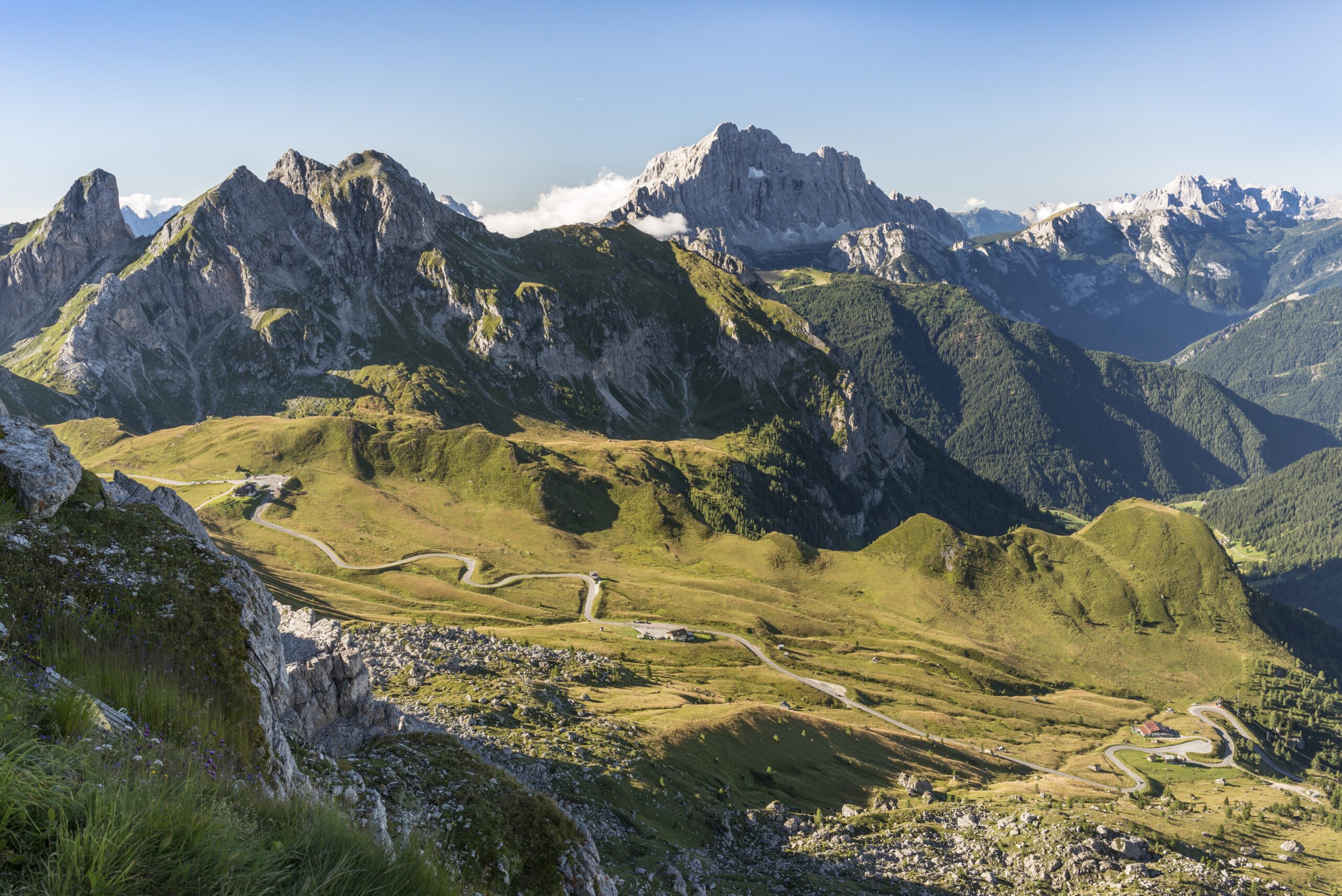
Notably, Monte Civetta isn’t the highest peak in the Dolomites. Marmolada holds that title at 3,343 meters. Civetta isn’t even the most-climbed — the Tre Cime di Lavaredo see more daily traffic. What Civetta has, in a way no other Dolomites peak quite matches, is presence. The Northwest Face rises 1,200 meters above the valley floor and stretches three kilometers wide. Walter Bonatti called it “la Parete delle Pareti” — the Wall of Walls. Stand at Rifugio Tissi at sunset and watch the entire face turn pink, and you understand why generations of climbers have made the pilgrimage.
This guide covers what you actually need to know to climb Civetta in 2026. Three Via Ferratas reach the 3,220m summit, ranging from medium difficulty on the Normal Route via Sentiero Tivan to severely difficult on the Via Ferrata Tissi. The Solleder-Lettenbauer Route on the Northwest Face remains the legendary trad climb at UIAA grade VI. Gustav Lettenbauer and Emil Solleder first climbed it in 1925. Today it’s still considered one of the great test pieces of Dolomites alpinism. Most climbers come for the via ferratas. A smaller community comes for the wall.
Logistics are straightforward. Fly into Venice (2 hours by car) or Innsbruck (2.5 hours). Base yourself in Alleghe to the west or Pecol/Selva di Cadore to the east. Use the cable lifts to gain initial altitude. Sleep at Rifugio Coldai, Rifugio Tissi, or Rifugio Torrani depending on your route. The full ascent takes 7-10 hours of moving time from valley parking. Plan a 2-3 day expedition to allow refuge nights and weather flexibility. Budget €200-€600 per day depending on whether you climb independently or hire an Alpine Guide.
Find Hotels, Flights & Trips for the World’s Best Hiking Destinations
The Global Summit Guide Travel Shop on Expedia — curated for outdoor adventurers, mountaineers, and serious hikers. Patagonia to the Alps. Nepal to the Rockies. Curated lodging for every region we cover.
Explore Travel Shop on Expedia →Monte Civetta At a Glance
The essential facts about Civetta, organized for fast reference. Detailed sections follow below.
| Summit elevation | 3,220 m (10,564 ft) |
|---|---|
| Location | Dolomiti Bellunesi, Veneto, Italy |
| Coordinates | 46.3801°N, 12.0533°E |
| Mountain group | Dolomites, Italian Alps |
| Protected area | UNESCO World Heritage Site (Dolomites, inscribed 2009) |
| Northwest Face | 1,200m tall × 3km wide — “Wall of Walls” (Parete delle Pareti) |
| First ascent | 1855 (likely) — Simeone di Silvestro, local hunter, via Tivan route |
| First recorded ascent | May 31, 1867 — Francis Ford Tuckett with guides Melchior and Jakob Anderegg |
| Solleder-Lettenbauer Route | 1925 — Emil Solleder & Gustav Lettenbauer, NW Face direct (UIAA VI) |
| Main ascent routes | Normal Route (Sentiero Tivan), Via Ferrata degli Alleghesi, Via Ferrata Tissi |
| Elevation gain from valley parking | ~1,520 m (4,987 ft) |
| Nearest gateway villages | Alleghe (west) and Pecol / Selva di Cadore (east) |
| Key refuges | Rifugio Coldai (2,135 m), Rifugio Tissi (2,281 m), Rifugio Torrani (2,910 m) |
| Expedition duration | 2-3 days typical; 1 day possible from cable-lift access for experienced ferrata climbers |
| Best climbing season | Late June to mid-September; peak window July to mid-August |
| Park fee | None — free access; refuge bookings paid directly |
| 2026 guided cost range | €800-€1,500 for 2-3 day guided programs (Alpine Guide + half-board) |
| Prerequisites | Via ferrata experience, head for exposure, good fitness; Solleder Route requires UIAA VI trad climbing |
| Nearest international airports | Venice Marco Polo (VCE) — 2 hr; Innsbruck (INN) — 2.5 hr; Treviso (TSF) — 2 hr |
What “the Wall of Walls” actually means. The Northwest Face of Civetta isn’t the tallest face in the Dolomites by raw vertical relief — Cima Grande di Lavaredo, Pelmo, and Marmolada all have comparable verticality. What makes Civetta’s NW Face singular is the combination. The face delivers 1,200 meters of relief, 3 kilometers of horizontal span, and near-uniform steepness across the entire wall. Additionally, the setting lets you see the whole wall at once from the Rifugio Tissi terrace. It’s a single coherent monument, not a complex of ridges and gullies. Photographs rarely capture the scale because there’s nothing else in frame to provide reference.
Why Monte Civetta Matters: A Place in Alpine History
To understand why climbers travel from across Europe to climb a single Dolomites peak, you need to understand what Civetta represents in alpine history. Three things converge on this mountain that don’t combine anywhere else in the Alps.
The Wall of Walls (Parete delle Pareti)
The Northwest Face is what climbers come to see. At 1,200 meters tall and 3 kilometers wide, it’s the largest single rock face in the Dolomites — and arguably the largest in the entire Alps when measured by uninterrupted continuity. The face appears nearly uniformly steep across its full width, with subtle variations in line and texture that experienced rock climbers can read like terrain. Italian climber Walter Bonatti reportedly coined the name “Parete delle Pareti” — Wall of Walls — and the title has stuck across generations of Dolomites climbing literature.
What makes the face unique isn’t just size. Most major alpine faces present complex geometries — ridges, snow couloirs, hanging glaciers. Civetta’s NW Face is pure rock, nearly all vertical, with a coherent visual identity. You can see it whole from across the valley. Photographers love it for that reason. So do climbers, because the face offers genuine route choice rather than a single forced line.
The Solleder-Lettenbauer Route (1925)
On August 7, 1925, Gustav Lettenbauer and Emil Solleder traced a direct line up the Northwest Face. They climbed 1,200 meters of vertical rock in a single day using only hemp ropes, hobnail boots, and a handful of pitons. The route is graded UIAA VI today — solid trad climbing on variable rock quality — and the 1925 ascent remains a watershed moment in alpine history. Solleder went on to climb the great Eiger Northwest Face routes; Lettenbauer continued establishing classic Dolomites lines through the 1930s.
The route still attracts strong trad climbers, though attempts have decreased as modern alternatives elsewhere have opened. Climbers who attempt the Solleder typically allocate 12-18 hours on the wall, with most parties bivouacking partway up. The route’s combination of historical significance and continuing difficulty makes it the test piece for accomplished Dolomites climbers.
The Trio of Via Ferratas
Beyond the trad climbing legacy, Civetta hosts three of the most celebrated Via Ferratas in the Dolomites. The Via Ferrata degli Alleghesi traces the east face — long, exposed, and consistently rated among the most spectacular ferratas anywhere in the Alps. The Via Ferrata Tissi tackles the south face with a 300-meter near-vertical step, placing it among the most difficult ferratas in the Dolomites. The Normal Route via Sentiero Tivan provides a more moderate ascent, though it still involves 22 cable sections and serious exposure. Together, the three ferratas give climbers genuine route choice — by difficulty, by aspect, and by character.
The Alta Via 1 connection. Many hikers encounter Civetta not as climbers but as walkers on Alta Via 1 — the most popular long-distance trekking route in the Dolomites. The traverse along the NW Face base from Rifugio Coldai to Rifugio Tissi to Rifugio Vazzoler is one of the most spectacular alpine walks in Europe. Hikers who fall in love with the wall on the Alta Via often return years later as climbers. This pattern of visitor progression is unique to Civetta among major Dolomites peaks.
Who Should Climb Monte Civetta?
Civetta accommodates a wider range of climbers than most peaks of its stature, but each route has clear prerequisites. Honest self-assessment matters here — the consequences of getting in over your head on the upper Tissi or the Alleghesi traverse are serious.
Civetta Is Appropriate For:
Experienced via ferrata climbers. If you’ve completed multiple Grade C ferratas in the Dolomites (Sentiero delle Bocchette in Brenta, Ivano Dibona in Cortina, or similar), you have the foundation. The Normal Route is accessible to climbers at this level. The Alleghesi and Tissi require additional experience.
Climbers comfortable with sustained exposure. All three routes involve long sections of exposed climbing above significant drops. Climbers prone to vertigo or new to height exposure should build experience on shorter ferratas first.
Multi-day refuge trekkers wanting a summit objective. The 2-3 day Civetta program (Coldai night, ferrata day, Torrani descent) fits naturally into a longer Dolomites trip. Many climbers combine Civetta with the Alta Via 1 or with neighboring peaks like Pelmo or Marmolada.
Trad climbers building toward big-wall projects. The Solleder-Lettenbauer Route is among the most legendary trad climbs in the Alps. Climbers who’ve completed UIAA V-VI multi-pitch routes in Verdon, Frankenjura, or El Capitan can step up to the Solleder with appropriate preparation.
Photographers and mountain enthusiasts. Some peaks reward visiting even if you don’t summit. Civetta’s NW Face from Rifugio Tissi at sunset is among the most photographed scenes in alpine literature. The 2-day refuge approach justifies the trip even without a climb.
Civetta Is Not Appropriate For:
First-time via ferrata climbers. Civetta’s ferratas are intermediate-to-advanced, not beginner-friendly. Start on easier Dolomites ferratas (Punta Penia summit ferrata on Marmolada, or the simpler routes around Cortina) before attempting Civetta.
Climbers without head-for-heights. The exposure on all routes is significant and sustained. There’s no easy way to back out from the upper sections without committing to descent via the same exposed terrain.
Climbers on tight weather schedules. Dolomites afternoon thunderstorms are frequent and dangerous on exposed metalwork. Flexibility to wait a day or two for clear weather is essential.
Solo trad climbers without partner. The Solleder Route specifically requires a competent rope partner. Soloing is technically possible but inappropriate without elite experience.
The Three Routes Up Monte Civetta
Three Via Ferratas reach the Civetta summit, plus the trad rock route on the NW Face. Each has distinct character, difficulty, and ideal climber profile. Detailed comparisons follow.
| Route | Aspect | Difficulty | Best For | Time |
|---|---|---|---|---|
| Normal Route (Sentiero Tivan) | East-northeast | Medium ferrata | Descent; less-crowded ascent | 5-6 hrs |
| Via Ferrata degli Alleghesi | East | Medium-difficult ferrata | Standard ascent; most popular | 4-5 hrs |
| Via Ferrata Tissi | South | Difficult ferrata | Experienced climbers; vertical step | 4-5 hrs |
| Solleder-Lettenbauer Route | Northwest | UIAA VI trad rock | Elite trad climbers; historic line | 12-18 hrs |
Route 1: Via Ferrata degli Alleghesi (Standard Ascent)
The Via Ferrata degli Alleghesi is the most popular route up Monte Civetta. It’s the standard recommendation for fit, experienced ferrata climbers. The route starts from Casera di Pioda after taking the cable lifts up from Alleghe to Col dei Baldi, then continues via Lake Coldai and Rifugio Coldai. From there, the ferrata climbs a pillar to the side-summit of Punta Civetta (2,920m), then traverses the main ridge to the true summit. Easier sections of the lower pillar (UIAA II) are not equipped with cables — climbers move over rock using natural holds.
Route breakdown
- Cable lift access: From Alleghe, take the cableways to Col dei Baldi (1,946 m). This saves 800 meters of approach hiking but adds €15-€25 per lift.
- Hike to Rifugio Coldai: 2.5-3 hours from Col dei Baldi via Lake Coldai. Most climbers spend the night here at 2,135 m.
- Ferrata start: From the refuge, traverse to Casera di Pioda and begin the cable system. Initial pitches climb a pillar with exposed sections.
- Punta Civetta (2,920 m): The side-summit reached after 2-3 hours of ferrata climbing. Strong climbers continue immediately to the main summit; others rest here.
- Main ridge traverse: From Punta Civetta along the equipped ridge to the true summit at 3,220 m. Allow 1-2 hours.
- Summit: A small bivouac box (Bivacco Torrani) sits near the summit. The view spans the entire Dolomites.
- Descent: Most climbers descend via the Normal Route (Sentiero Tivan) to Rifugio Torrani at 2,910 m, then continue to Rifugio Coldai or back to the cable lifts the following day.
Strengths
- Most popular route — well-traveled and well-maintained
- Cable lift access reduces approach effort
- Spectacular ridge traverse to the summit
- Standard descent via Normal Route avoids re-climbing
- Refuge infrastructure supports 2-3 day expedition
Considerations
- Often crowded in peak season (July-August)
- Sustained exposure across full route length
- UIAA II uncabled sections require basic climbing skill
- Weather flexibility essential — no fast escape
Route 2: Via Ferrata Tissi (Difficult Ascent)
The Via Ferrata Tissi is one of the most difficult ferratas in the Dolomites. The route ascends the south face of Civetta through a 300-meter near-vertical step that places it among the hardest cable systems in the Alps. The approach starts from Rifugio Vazzoler in the south, ascending through the Val Civetta to the base of the wall. The vertical step is sustained and demanding — climbers need solid arm strength, comfortable rope technique, and complete confidence on overhanging ground.
Successfully completing the Tissi puts climbers at the Rifugio Torrani plateau, from which the summit traverse to Civetta proper is a relatively straightforward final section. Many ferrata enthusiasts who complete the Tissi consider it the highlight of their Dolomites climbing career — but the route demands appropriate preparation. Climbers who have completed Grade D ferratas elsewhere in the Alps are typically ready; those who haven’t should build experience first.
Strengths
- One of the most rewarding ferratas in the Dolomites
- Far less crowded than Alleghesi
- Pure vertical climbing on impressive terrain
- Direct ascent to Rifugio Torrani plateau
Considerations
- Difficult Grade D+ — not for moderate ferrata climbers
- Sustained vertical and overhanging sections
- Some rockfall danger on lower approaches
- Requires significant arm endurance
- Approach from Rifugio Vazzoler is longer than Alleghesi
Route 3: Normal Route (Sentiero Tivan)
The Normal Route via Sentiero Tivan is the historic line — the same approach climbed by Simeone di Silvestro in 1855 and again by Francis Ford Tuckett with the Anderegg brothers in 1867. Today, the route is more commonly descended than ascended, because the Alleghesi and Tissi offer more interesting climbing. However, the Tivan remains a viable ascent for climbers who want a less-crowded route or who plan to traverse the mountain. The route involves a marked path with around 22 cable sections and exposed scrambling.
Most climbers encounter the Tivan as the descent from a summit reached via the Alleghesi. In that direction, the route flows from Rifugio Torrani at 2,910m down to Rifugio Coldai or the Alleghe cable system. Some danger of rockfall exists, particularly in the upper section. The Tivan is rated medium difficulty for via ferrata climbers — easier than the Alleghesi traverse but still demanding for inexperienced climbers.
Strengths
- Historic significance — the first ascent line
- Less crowded than the Alleghesi
- Easier than the Tissi for moderate climbers
- Direct access to summit via Rifugio Torrani
- Standard descent route for traverse climbers
Considerations
- Less interesting climbing than the Alleghesi
- Some rockfall risk in upper sections
- 22 cable sections still demand attention
- Longer total time than other ferrata routes
Route 4: Solleder-Lettenbauer Route (Trad Climbing)
The Solleder-Lettenbauer Route is a different category of climbing entirely. This is not a ferrata — it’s a serious trad rock climb up the central Northwest Face, established by Gustav Lettenbauer and Emil Solleder on August 7, 1925. The route traces a near-direct line through 1,200 vertical meters of variable Dolomites limestone, with sections graded up to UIAA VI. Modern parties typically allocate 12-18 hours on the wall, with many bivouacking on a ledge partway up.
The route remains technically demanding by today’s standards. Loose rock in several sections requires careful gear placement. Route-finding is non-trivial — the line wanders to find the path of least resistance through complex terrain. Modern climbers attempting the Solleder should have prior experience on long Dolomites trad routes. Examples include the Cassin on Piz Badile or the Comici on Cima Grande. Additionally, climbers should be capable of leading UIAA VI on natural rock. Most parties also carry a small selection of pitons for variable protection.
Strengths
- One of the most historic trad routes in the Alps
- Direct line up the largest face in the Dolomites
- Sustained, varied climbing on Dolomites limestone
- Significant historical and aesthetic accomplishment
Considerations
- Reserved for elite trad climbers (UIAA VI+ leading)
- Variable rock quality requires careful protection
- Route-finding complexity adds time
- Many parties bivouac partway up
- Limited rescue access on the upper face
Monte Civetta Climbing History: From 1855 to 2026
Simeone di Silvestro, a local hunter from the Zoldo Valley, almost certainly made the first ascent of Monte Civetta in 1855. He climbed via what is now called the Sentiero Tivan — the route on the east side that became the Normal Route. No detailed records survive from his climb, but later interviews and the route knowledge he demonstrated when guiding Tuckett in 1867 strongly suggest the 1855 date is accurate.
English climber Francis Ford Tuckett climbed Monte Civetta with Swiss guides Melchior and Jakob Anderegg, led by local hunter Simeone di Silvestro. This is the first ascent recorded in alpine literature. Tuckett published the climb in the Alpine Journal, putting Civetta on the international climbing map for the first time and opening the era of Dolomites exploration by foreign mountaineers.
Through the 1890s, climbers began studying the Northwest Face. Several Italian and Austrian teams probed lines on the wall but found the rock quality, weather exposure, and route-finding complexity beyond the techniques available. The wall remained unclimbed for another three decades — an unusual gap in Dolomites climbing history given how thoroughly other major faces were explored in this period.
Gustav Lettenbauer and Emil Solleder made the first ascent of the Northwest Face in a single day on August 7, 1925. Their direct line traced 1,200 vertical meters using hemp ropes, hobnail boots, and a small selection of pitons. The climb is now recognized as one of the watershed ascents in alpine history. Solleder went on to establish classic routes elsewhere in the Alps. Meanwhile, Lettenbauer continued opening Dolomites lines through the 1930s. The Solleder-Lettenbauer Route remains a UIAA grade VI test piece today.
Through the early 1930s, Italian climber Emilio Comici established additional lines on the NW Face and surrounding terrain. The Comici routes brought modern protection techniques and faster climbing styles to the wall. By the late 1930s, Civetta had become one of the proving grounds for European alpinism, with multiple new lines opened each season.
The Italian Alpine Club (CAI) installed the first via ferrata cables on Civetta in the post-war period. The Sentiero Tivan was equipped with permanent cables to formalize the historic ascent route. The Alleghesi system was installed in stages through the 1950s and 1960s. The Tissi ferrata followed in the 1960s, designed specifically as a difficult test piece. These installations transformed Civetta from a peak for elite climbers into a destination accessible to fit, experienced amateurs.
Refuge infrastructure expanded through the 1970s and 1980s. Rifugio Coldai, Rifugio Tissi, and Rifugio Torrani all received expansions or rebuilds, allowing larger climbing groups to base on the mountain. The Bivacco Torrani was installed near the summit as an emergency shelter. By the 1990s, commercial guiding had become routine, with Alpine Guides from Alleghe, Cortina, and Belluno offering structured Civetta programs.
UNESCO inscribed the Dolomites on the World Heritage List in June 2009, recognizing the outstanding geological and aesthetic value of the range. Monte Civetta falls within the inscribed area as part of the Dolomiti Bellunesi cluster. The designation brought additional protection to the wall environments and channeled tourism revenue into refuge maintenance and trail conservation. Climbing access remained unchanged — no permits or quotas were introduced.
Italy’s pandemic-era travel restrictions suspended international climbing on Civetta for most of 2020. Refuges operated at reduced capacity through 2021. By 2022, climbing returned to roughly 80% of pre-pandemic volume, and the 2023 and 2024 seasons saw full recovery. Local Alpine Guides from Alleghe report that domestic Italian climbing increased during the pandemic and has remained strong in subsequent seasons.
The 2026 climbing season is active, with refuges open from mid-June through mid-September and full booking volumes reported across the major operators. Cable systems on all three ferratas were inspected and maintained over the 2025-2026 off-season. Refuge prices have increased moderately in 2026 (typical half-board now €70-€85). Cable lift access from Alleghe operates daily during the peak season. Climbers planning 2026 trips should book refuges 2-4 weeks in advance for peak July-August windows.
Refuges, Logistics & Cable Lift Access
Climbing Civetta requires careful planning around the refuge network. Additionally, the cable lift systems shorten approach time considerably. Here’s what each option provides.
The Three Key Refuges
| Refuge | Elevation | Position | Capacity | 2026 Half-Board |
|---|---|---|---|---|
| Rifugio Coldai | 2,135 m | NE side, near Lake Coldai | ~90 beds | €70-€85 |
| Rifugio Tissi | 2,281 m | SW side, NW Face viewpoint | ~70 beds | €70-€85 |
| Rifugio Torrani | 2,910 m | South side, summit plateau | ~30 beds | €75-€90 |
| Bivacco Torrani (emergency) | ~3,150 m | Near summit | ~8 places | Free (emergency only) |
Rifugio Coldai is the standard base for Via Ferrata degli Alleghesi ascents. Most climbers arrive at Coldai via the cable lift from Alleghe to Col dei Baldi, then hike 2.5-3 hours to the refuge. From Coldai, the next day’s climb traverses to Casera di Pioda before starting the ferrata.
Rifugio Tissi sits at the base of the Northwest Face and provides the iconic photographic view of the Wall of Walls. Tissi is essential for climbers attempting the Solleder-Lettenbauer Route and provides the best view of the wall at sunset. The refuge is also the standard waypoint for Alta Via 1 hikers and via ferrata climbers attempting the Tissi route.
Rifugio Torrani sits at 2,910m near the summit plateau and is the highest refuge on Civetta. Climbers who summit via the Alleghesi typically descend to Torrani for the night, then descend to Coldai or back to the lifts the next day. Torrani is small (only about 30 beds) and books out fast — reservations 3-4 weeks ahead are essential for July-August.
Cable Lift Access
Two cable lift systems serve Civetta climbers. From the western (Alleghe) side, the cable car ascends from Alleghe village to Col dei Baldi at 1,946m — the standard starting point for Alleghesi ascents. From the eastern (Pecol) side, the Pecol cable lift accesses higher altitudes useful for some approaches. 2026 ticket prices run €15-€25 per ride, with multi-day passes available for €40-€60. The Alleghe cableways operate daily from late June through mid-September.
Refuge booking is essential. All three Civetta refuges require advance booking, particularly during the July-August peak window. Walk-up beds are rarely available. Rifugio Torrani (with only 30 beds) is the most competitive — book 4-6 weeks ahead for peak season. Coldai and Tissi typically have availability 2-3 weeks out. Book directly through the refuge websites or via the official CAI booking portal. Most refuges require half-board (dinner + breakfast) included in the room price.
Which Route Fits Your Situation?
The biggest mistake climbers make on Civetta is matching themselves to the most famous route rather than the route that fits their actual experience. Use this matrix to narrow your choice.
Match Yourself to a Civetta Route
When to Climb Civetta: Season-by-Season Guide
Late June to Early July: Early Season
The early season opens when refuges begin operations and the cables clear of residual snow. Conditions can be excellent (cool temperatures, fewer crowds) but some risk remains from late-season snow patches on the upper ridge. Some refuges open in late June, others in early July. Cable lift schedules are typically reduced. Climbers with flexible dates often find this window offers the best balance of accessibility and quietness.
Mid-July to Mid-August: Peak Window
The prime Civetta climbing window. All refuges are fully open. Cable lifts run daily. Weather is most stable during this period, though afternoon thunderstorms remain a daily concern. Crowds are at their peak — particularly on the Alleghesi route, where queues can develop at cable sections during high-traffic periods. Refuge bookings are essential 3-6 weeks in advance. Pricing is at seasonal maximum.
Mid-August to Mid-September: Late Season
Generally, late summer brings declining crowds but increasing weather risk. Refuges remain open through mid-September. Cable lifts typically continue daily operation. Daylight shortens noticeably, requiring earlier starts for full ascents. Some climbers consider late August through early September the connoisseur’s window — same conditions as peak season but with significantly fewer climbers on the routes.
October to May: Off-Season
Refuges close. Then the cables can ice up. Rockfall risk increases as temperature variations destabilize loose rock. The mountain is technically climbable for experienced winter alpinists, but the operational infrastructure (refuges, lifts, rescue) is absent. Most climbers wait until the following June. Some ski mountaineers attempt Civetta in late spring, but conditions are highly variable and the routes don’t lend themselves to ski descent.
Climbing Civetta in 2026: Cost Breakdown
Civetta is among the more affordable major Dolomites climbs. Compared to a guided Mont Blanc expedition (€2,500-€4,000) or a Matterhorn ascent (€1,500-€2,500), a guided Civetta program offers a comparable experience at considerably lower cost.
Independent Climbing Costs
| Cost Component | 2026 Amount | Notes |
|---|---|---|
| Refuge half-board (per night) | €70-€90 | Coldai, Tissi, or Torrani; includes dinner + breakfast |
| Cable lift access | €15-€25 per ride | Alleghe cableways to Col dei Baldi; multi-day passes available |
| Via ferrata gear rental | €30-€50 for the trip | Harness, helmet, via ferrata set (lanyards + carabiners) |
| Food & water for climb day | €15-€30 | Lunch on the route; refuges provide breakfast and dinner |
| Accommodation in Alleghe (pre/post) | €60-€150 per night | Budget hostels to mid-range hotels |
| Total 2-3 day independent budget | €200-€400 | Excluding international travel to the Dolomites |
Guided Expedition Costs
| Operator Program | 2026 Cost | What’s Included |
|---|---|---|
| 3-day Via Ferrata Alleghesi (Italian Alpine Guides) | €1,000-€1,400 | Guide fee, refuge half-board, via ferrata instruction, equipment |
| 2-day Civetta program (Dolomist, similar operators) | €700-€1,000 | 1 guide day, Rifugio Torrani half-board, accident insurance |
| Custom private guiding | €400-€600 per day | 1:1 or 1:2 ratio; flexible itinerary; experienced Alpine Guide |
| Multi-day Dolomites traverse including Civetta | €1,800-€2,500 | 5-7 day program covering Alta Via 1 + Civetta summit |
| Solleder Route guided ascent | €800-€1,200 per day | Specialized trad climbing guide; 2-day program typical |
Compared to other Dolomites peaks. Monte Civetta sits at the mid-tier of Dolomites climbing costs. Easier peaks like Pelmo or Sass Pordoi can be climbed for €100-€250 independently. Marmolada (the highest Dolomites peak at 3,343m) requires similar budgets to Civetta. Cassin Route on Piz Badile or the harder Brenta classics run €1,500-€2,500 guided. Civetta offers genuinely exceptional climbing at moderate cost — a key reason it has remained popular across generations of climbers.
Gear Checklist for Monte Civetta
Civetta gear requirements depend on which route you climb, but the core kit applies across all ferrata ascents. Trad climbers attempting the Solleder Route need additional protection beyond this list.
Via Ferrata Essential Kit
- Via ferrata set (lanyards + energy absorber) — CE EN 958 certified; modern Y-shaped lanyards with two carabiners
- Climbing harness — sport climbing or alpine harness with adjustable leg loops
- Helmet — required for rockfall protection
- Via ferrata gloves — fingerless or full-finger; protect hands on the cable
- Approach shoes or light boots — sticky rubber soles for the rock sections
- 30-50L backpack — to carry water, food, layers, and any extra gear
Clothing System
- Base layer top and bottom — merino or synthetic
- Light mid-layer fleece or softshell — for cool morning starts at refuges
- Light insulated jacket — synthetic or down sweater for summit and rest stops
- Hardshell jacket — Gore-Tex or similar; Dolomites weather can change rapidly
- Hardshell or hiking pants — durable, climbing-appropriate
- Sun hat — UV exposure on the upper face is severe
- Warm hat — for refuge nights and pre-dawn starts
Personal Items
- Sunglasses (Category 3-4)
- Sunscreen SPF 30+ and lip balm
- Headlamp — required if starting before dawn or in case of delay
- Water bottles or hydration system (2L capacity)
- Cash (euros) — for refuges and cable lifts; some refuges accept cards but cash is more reliable
- Personal first aid kit — blister care, ibuprofen, basic supplies
- Travel insurance with mountain rescue coverage — strongly recommended
Solleder Route Additional Gear
- Full trad rack — single set of cams (small to medium), nuts, hexes if available
- Small selection of pitons — for variable Dolomites protection
- 60m or twin 50m ropes — for multi-pitch belaying and rappel descent
- Alpine slings and runners — 6-8 sewn slings for anchor building
- Bivouac gear — most parties bivouac partway up the route
- Daypack (suitable for hauling) — gear for 2-day climb without refuge access
Frequently Asked Questions About Climbing Monte Civetta
How tall is Monte Civetta and where is it located?
Monte Civetta rises to 3,220 meters (10,564 feet) in the Italian Dolomites, in the province of Belluno in the Veneto region. The coordinates are 46.3801°N, 12.0533°E. The mountain sits between the villages of Alleghe to the west and Zoldo Valley to the east. Both are within roughly 2 hours of Venice by car. The Northwest Face is widely known in climbing literature as the “Wall of Walls” (Parete delle Pareti), measuring 1,200 meters tall and 3 kilometers wide. This makes it one of the largest rock faces in the entire Alps. Civetta forms part of the Dolomiti Bellunesi and is included in the UNESCO World Heritage Site listing for the Dolomites (2009).
What are the main routes up Monte Civetta?
Three main routes lead climbers to the summit of Monte Civetta. The Normal Route via the Sentiero Tivan is the easiest line — a marked path with 22 cables and exposed scrambling sections from Rifugio Coldai or Rifugio Tissi. Typically it’s descended rather than ascended. The Via Ferrata degli Alleghesi climbs the east face from Casera di Pioda to the side-summit of Punta Civetta (2,920m) then traverses the main ridge to the summit. This is the most popular ascent route at moderate difficulty. The Via Ferrata Tissi ascends the south face through a 300m near-vertical step. It’s considered one of the most difficult ferratas in the Dolomites. The Solleder-Lettenbauer Route on the Northwest Face (1925) remains the legendary classic rock climb at UIAA grade VI.
How difficult is climbing Monte Civetta?
Monte Civetta’s difficulty depends heavily on which route you choose. The Normal Route via Sentiero Tivan is rated medium difficulty for experienced via ferrata climbers and involves around 22 cable sections. The Via Ferrata degli Alleghesi is graded medium-difficult and requires solid via ferrata experience plus a head for exposure. The Via Ferrata Tissi is graded difficult and is suitable only for experienced ferrata climbers comfortable with sustained vertical rock. The Solleder-Lettenbauer Route on the Northwest Face is a UIAA grade VI multi-pitch rock climb spanning 1,200 vertical meters. This is serious alpine rock climbing reserved for accomplished trad climbers. The elevation gain from valley parking to the summit is approximately 1,520 meters regardless of route.
When is the best time to climb Monte Civetta?
The Monte Civetta climbing season runs from late June through mid-September. July and August offer the most stable weather and reliable conditions on the via ferratas. Early July through mid-August represents the peak window — refuges are fully open, the cable systems are clear of snow, and afternoon thunderstorms are at moderate frequency. June can carry residual snow on the cables and approaches. September brings shorter daylight and increasing risk of early-season snow on the upper sections. October through May is off-season — refuges close, the cables can ice up, and rockfall risk increases.
How much does climbing Monte Civetta cost in 2026?
Independent climbers can ascend Monte Civetta on a budget of approximately €200-€400 for a 2-3 day expedition. This covers refuge half-board (€70-€90 per night), cable lift access (€15-€25 per ride), and food. Guided expeditions with a certified Alpine Guide cost approximately €400-€600 per person per day. Most operators offer 2-3 day Civetta programs in the €800-€1,500 range. The 3-day Via Ferrata degli Alleghesi program (a popular guided format) typically runs €1,000-€1,400 per person. This includes guide fee, refuge nights, and via ferrata instruction. Equipment rental (harness, helmet, via ferrata set) adds approximately €30-€50 for the trip. Park access to the Dolomites is free; there are no permit fees.
What’s the “Wall of Walls” and why is it famous?
The Northwest Face of Monte Civetta is widely called “la Parete delle Pareti” — Italian for “Wall of Walls.” The name was reportedly coined by Walter Bonatti. It refers to a 1,200-meter-tall and 3-kilometer-wide rock face that’s nearly uniformly steep across its full span. This makes it one of the largest single rock faces in the entire Alps. The wall is famous for three reasons. First, the sheer scale — most photographs fail to convey because there’s no reference object. Second, the 1925 Solleder-Lettenbauer Route established the wall as one of the great trad climbs in alpine history. Third, the view from Rifugio Tissi at sunset is among the most photographed alpine scenes in Europe. Climbers who reach the Tissi terrace often describe the moment as the highlight of their Dolomites trip — even those who never set foot on the wall itself.
Do I need a guide to climb Monte Civetta?
A guide is not legally required for climbing Civetta. Independent climbers regularly ascend all three Via Ferrata routes without professional guidance. However, guides are strongly recommended for first-time Dolomites visitors, climbers without recent ferrata experience, and anyone attempting the difficult Via Ferrata Tissi. Italian Alpine Guides (UIAGM/IFMGA certified) operate from Alleghe, Cortina, and Belluno. Most run structured 2-3 day Civetta programs including refuge bookings, equipment, and instruction. For the Solleder-Lettenbauer Route specifically, a guide is essential unless you have extensive trad climbing experience and a strong partner. The route is too serious for casual attempts.
What refuges should I book on Monte Civetta?
Three refuges serve climbers on Monte Civetta. Rifugio Coldai (2,135m) on the northeast side is the standard base for Via Ferrata degli Alleghesi ascents. Rifugio Tissi (2,281m) on the southwest provides the iconic view of the Northwest Face — essential for Solleder Route climbers and recommended for any visitor. Rifugio Torrani (2,910m) sits near the summit plateau and is the standard overnight stop for climbers who summit via the Alleghesi. All three require advance booking, particularly during the July-August peak window. Rifugio Torrani with only 30 beds is the most competitive. Book 4-6 weeks ahead for peak season; 2-3 weeks ahead for shoulder season.
Can I climb Monte Civetta in one day?
A one-day Civetta ascent is technically possible from cable-lift access but requires significant fitness and experience. Strong climbers can take the Alleghe cableways to Col dei Baldi. From there, hike to Rifugio Coldai and climb the Via Ferrata degli Alleghesi to the summit. Then descend via the Normal Route — all in 10-12 hours of moving time. This requires early starts (4-5 am from the lifts), excellent weather, and the ability to maintain a fast pace on technical terrain. Most climbers find the experience more rewarding and safer with at least one refuge night. The 2-3 day approach allows weather flexibility, better recovery, and time to appreciate the mountain.
How does Civetta compare to other Dolomites peaks?
Among major Dolomites peaks, Monte Civetta sits at the upper tier of difficulty for via ferrata climbers. The Tre Cime di Lavaredo are more accessible — the standard ascent of Cima Grande involves easier ferrata terrain and is more crowded. Marmolada (the highest Dolomites peak at 3,343m) offers a glacier-and-ferrata route at similar overall difficulty to Civetta. Pelmo (3,168m) is a different category — a more traditional alpine peak with rock scrambling rather than equipped ferratas. The Brenta Dolomites offer the longest ferrata circuit (Bocchette) but at moderate per-route difficulty. Civetta’s unique combination of the legendary NW Face plus three quality ferratas makes it distinctive among Dolomites peaks. Climbers often rank it as the single most rewarding day in the entire range.
Monte Civetta Planning Resources
Sources & Further Reading
- SummitPost — Monte Civetta route descriptions and historical climbing records
- Mountain Project — Monte Civetta area guide and Solleder-Lettenbauer Route notes
- Dolomiti.org — Official Alleghe tourism portal and Mount Civetta climbing information
- Komoot — Monte Civetta hiking and ferrata route summaries
- Mountains For Everybody — Monte Civetta Normal Route detailed guide (April 2026)
- Via Ferrata Dolomites — Civetta great traverse guide and operator program
- Dolomist — 2026 guided Civetta programs and Alpine Guide services
- Explore-Share — 3-day Via Ferrata degli Alleghesi program and pricing
- UNESCO World Heritage Centre — Dolomites inscription (2009)
- Italian Alpine Club (CAI) — refuge booking portal and via ferrata maintenance records
- Francis Ford Tuckett — Alpine Journal account of the 1867 first recorded ascent
- American Alpine Journal — Solleder-Lettenbauer Route historical records
Last updated: May 24, 2026. Next scheduled update: April 2027 (pre-season verification of refuge prices and operator programs).
Planning a Dolomites Climbing Trip?
Monte Civetta is one of the great climbs of the Italian Dolomites. For other iconic Alpine peaks including Mont Blanc, Matterhorn, Marmolada, and the Eiger, see our Alps Classics collection with route guides and 2026 conditions.
View Alps Classics Collection →Was this helpful?
🏔Related peaks nearby
🧭Explore & compare
Global Summit Guide is an independent mountaineering resource founded in 2026. The team combines first-hand trekking and climbing experience with in-depth research and professional health and nutrition review to help climbers choose objectives, prepare properly, and stay safe.
Health, altitude, and nutrition content is reviewed by Taylor Ludlow (Registered Nurse) and Brigg Hoopes (Nutritionist).
What We Don't Know Yet
Mountain information changes quickly. This box explains the limits of what this page can responsibly promise.
- Route conditions, trailhead access, crevasse exposure, stream crossings, and rescue access may vary from published planning guidance.
- Visa, passport, vaccination, border, insurance, and local transportation rules may change before your trip.
- Route conditions, snowpack, closures, and weather can change quickly after this page is updated.
- Permit rules, fees, quotas, and reservation windows may change between review cycles.
- Operator availability, pricing, guide ratios, and cancellation terms can change by season.
Verify current conditions with official land managers, guide services, local forecasts, and current route reports before booking or climbing.
Part of this Global Summit Guide cluster
Explore the complete Mountains guide for more context, routes, planning links, and related resources.
Mountaineering, rock and ice climbing, glacier travel, and high-altitude activity are inherently dangerous and can result in serious injury or death. The information on Global Summit Guide is provided for general informational and educational purposes only and is not a substitute for professional instruction, qualified guiding, proper equipment, or your own judgment and experience.
Route conditions, weather, snowpack, permits, regulations, and hazards change constantly and may differ from what is described here. Details may be incomplete, out of date, or contain errors. Always verify current information with local authorities, certified guides, and official sources before making any decision in the mountains.
Nothing on this site is medical, legal, or financial advice. Our fitness, acclimatization, altitude, and nutrition content is general in nature; consult a qualified physician before beginning any strenuous exercise program or exposing yourself to high altitude.
You are solely responsible for your own safety and decisions. To the fullest extent permitted by law, Global Summit Guide and its team accept no liability for any loss, injury, damage, or expense arising from use of, or reliance on, this information. By using this site you acknowledge these risks and accept these terms.
Some links on this site may be affiliate links. If you buy through them we may earn a small commission at no extra cost to you; this never affects our recommendations.
Global Summit Guide recommendation path
Next Best Mountain to Research
Use these recommendations to continue the right planning path instead of stopping on one page.
Use current permit, weather, route, and operator information before booking or climbing.