
Last updated May 25, 2026
Climbing Monte Viso 2026: The ‘King of Stone’ of the Cottian Alps, the Via Mathews South Face Route & the Source of the Po River
At 3,841 meters, Monte Viso (Monviso) rises as one of the Alps’ most distinctive pyramidal peaks — the “King of Stone” that dominates the Cottian Alps and the source of Italy’s longest river. The mountain stands isolated above lesser surrounding peaks, visible from across the Po Valley and from much of Piedmont. The Via Mathews 1861 first ascent route via Rifugio Quintino Sella, the moderate UIAA III scrambling, the Pian del Re Po River source — the complete 2026 climbing guide.
Monte Viso occupies a singular position in Italian mountaineering. The peak isn’t the highest in Italy — Mont Blanc (Monte Bianco) claims that title at 4,810m, nearly 1,000 meters taller. It isn’t even the highest in the broader Alps — many of the 82 official 4,000-meter peaks tower above it. What Monte Viso holds, definitively, is iconic status as the most distinctive isolated pyramid in the entire Alps and the absolute monarch of its surrounding range. The mountain rises 2,062 meters of prominence above the nearest higher peak — making it the 10th most prominent peak in the entire Alps. Its isolated pyramidal shape stands out among all the mountains of Piedmont like an isolated giant among a crown of far lesser peaks. From the Po Valley plain, from the Mont Blanc Massif looking south, from the Queyras valleys of France, Monte Viso’s distinctive silhouette is unmistakable.
The mountain stands at the watershed between Italy and France in the Cottian Alps (Italian: Alpi Cozie). The range straddles the border between Piedmont in Italy and the Auvergne-Rhône-Alpes and Provence-Alpes-Côte d’Azur regions of France. Monte Viso is the highest peak of the entire Cottian Alps range and the highest mountain located entirely within Piedmont. Its summit sits less than two miles from the French border, with its western slopes giving rise to the Guil river that flows through the French Queyras. Its eastern slopes give rise to the Po River — Italy’s longest waterway — whose source springs forth at Pian del Re (2,020m) at the head of the Po Valley. Monte Viso is therefore not just a climbing destination but a geographically and culturally significant mountain — the birthplace of Italy’s most important river.
The climbing itself sets Monte Viso apart from peer Alpine objectives. The standard South Face route (Via Mathews) is rated UIAA III with via ferrata sections — a mixed scrambling tour on easy rock with snowfields rather than pure mountaineering. The route doesn’t reach the technical difficulty of harder Alpine 4,000m peaks but provides considerable summit day commitment with sustained Class 3-4 climbing combined with high-alpine environment. The climb provides genuine alpinism without demanding extreme technical competence. Many guides recommend Monte Viso as ideal preparation for Mont Blanc and the Matterhorn — a major alpine summit climb in its own right that builds the foundation for harder objectives. The 1861 first ascent by William Mathews, Frederic Jacomb, and guide Michel Croz established the route still used by most modern parties.
Find Hotels, Flights & Trips for the World’s Best Hiking Destinations
The Global Summit Guide Travel Shop on Expedia — curated for outdoor adventurers, mountaineers, and serious hikers. Patagonia to the Alps. Nepal to the Rockies. Curated lodging for every region we cover.
Explore Travel Shop on Expedia →This guide covers what you need to climb Monte Viso in 2026. The Via Mathews South Face standard route from Rifugio Quintino Sella in detail. The 1861 first ascent context — Monte Viso being among the first major Alpine peaks climbed during the “golden age” of mountaineering. Approach logistics from Saluzzo through the Po Valley to Pian del Re and the famous source of the Po River. Rifugio Quintino Sella accommodation and Italian alpine club (CAI) discounts. Gear, season analysis, and operator pricing in EUR. And honest assessment of who should attempt this peak. Monte Viso doesn’t require the technical climbing competence of harder Alpine objectives. However, the long summit day, high-altitude environment, and Italian alpine setting reward experienced climbers more than first-time alpine visitors.
Monte Viso At a Glance
The essential reference facts for Monte Viso. Detailed sections follow below.
| Summit elevation | 3,841 m (12,602 ft) |
|---|---|
| Alternative names | Monviso (Italian); Vísol (Occitan); Viso (Piedmontese); Mont Viso (French) |
| Location | Piedmont, northwestern Italy |
| Coordinates | 44.6675°N, 7.0917°E |
| Mountain range | Cottian Alps (Alpi Cozie) |
| Border status | Italy-France watershed; summit on Italian side, very near French border |
| Prominence | 2,062 m (6,765 ft) — 10th highest in the Alps |
| Range rank | Highest peak in the Cottian Alps |
| Italy ranking | Highest mountain located entirely within Piedmont |
| Distinctive feature | Isolated pyramidal shape; “King of Stone” of the Cottian Alps |
| Visibility | Visible from the Po Valley plain; Mont Blanc Massif looking south; Queyras valleys of France |
| River source | Source of the Po River (Italy’s longest river) at Pian del Re (2,020m) |
| First ascent | August 30, 1861 — William Mathews and Frederic Jacomb with guide Michel Croz |
| Standard route | South Face (Via Mathews) — UIAA III scrambling with via ferrata sections |
| Approach trailhead | Pian del Re (2,020 m) — large car park at head of Po Valley |
| Mountain hut | Rifugio Quintino Sella (2,640 m) — standard high camp |
| Trip duration | 2-3 days with overnight at Rifugio Quintino Sella |
| Summit day length | 8-12 hours round trip from rifugio |
| Best season | Late June to mid-September (peak mid-July to August) |
| Rifugio accommodation | €60-€80 per night with half-board (CAI discounts available) |
| 2026 guided cost | €700-€1,800 per person depending on operator and program |
| Gateway town | Saluzzo (Italy) — all services; ~1 hour southwest of Turin |
| Access village | Crissolo — small village before Pian del Re road end |
| Nearest airport | Turin Airport (TRN) — approximately 90 minutes’ drive |
Why Monte Viso ranks 10th in the Alps for prominence. Topographic prominence measures how much a peak rises above the highest col connecting it to a higher peak. Monte Viso’s 2,062 meters of prominence places it 10th among all Alpine peaks — extraordinary for a 3,841-meter peak when many Alpine 4,000m peaks have far less prominence. The reason is geographic isolation: Monte Viso stands alone in the southern Cottian Alps with no nearby competitor peaks. The nearest higher peak is far away in the Graian Alps or the Mont Blanc Massif. This isolation gives Monte Viso its distinctive visibility from across the Po Valley and its iconic pyramidal silhouette. The mountain dominates its surroundings completely — no nearby peaks compete with its dramatic profile. For climbers, this isolation translates to extraordinary summit views: a 360-degree panorama with no obstruction from neighboring high peaks. From the summit you see Mont Blanc to the north, the Maritime Alps to the south, the Po Valley to the east, and the entire French Queyras to the west.
Why Monte Viso Matters in Alpine Mountaineering
Monte Viso holds a precise position in European mountaineering culture that few other peaks match. The mountain combines four distinguishing elements. First, status as one of the most isolated and prominent Alpine peaks at 10th in prominence. Second, historic importance as among the first major Alpine peaks climbed in the 1861 “golden age.” Third, cultural significance as the source of the Po River. Finally, accessibility as a major alpine summit climb without extreme technical demands. For climbers building toward Mont Blanc, the Matterhorn, or similar Alpine objectives, Monte Viso provides ideal preparation that delivers considerable summit achievement.
The Most Distinctive Isolated Pyramid in the Alps
Few mountains anywhere match Monte Viso for distinctive isolated profile. The mountain rises as a near-perfect pyramidal shape from surrounding lower terrain. Its 2,062-meter prominence places it 10th in the entire Alps — extraordinary for a sub-4,000m peak when most of the higher-prominence peaks are Alpine 4,000m giants. From the Po Valley plain looking west, Monte Viso’s isolated triangular silhouette is unmistakable. From the Mont Blanc Massif looking south, the peak’s pyramid stands out among lesser peaks. From the Queyras valleys of France looking east, the mountain dominates the eastern horizon. The visibility from such great distances reflects the geographic isolation — Monte Viso has no nearby competitor peaks of comparable height. For climbers, this isolation translates to extraordinary summit views: a 360-degree panorama with no obstruction from neighboring high peaks.
The 1861 First Ascent During the Golden Age
Monte Viso was among the first major Alpine peaks climbed during the “golden age of alpinism.” This 1850s-1860s period saw British climbers and their guides systematically climb the major Alpine peaks for the first time. The 1861 first ascent by William Mathews, Frederic Jacomb, and Chamonix guide Michel Croz represented a significant achievement in early Alpine climbing. Mathews was a founder of the Alpine Club (London) in 1857 — the world’s first mountaineering club. The Via Mathews route they established remains the standard climbing line today, 165 years later. The peak’s place in early Alpine climbing history adds historical resonance to modern ascents. The Via Mathews name itself preserves the first ascender’s memory in the route designation — a tradition common in Italian alpine climbing.
Source of the Po River
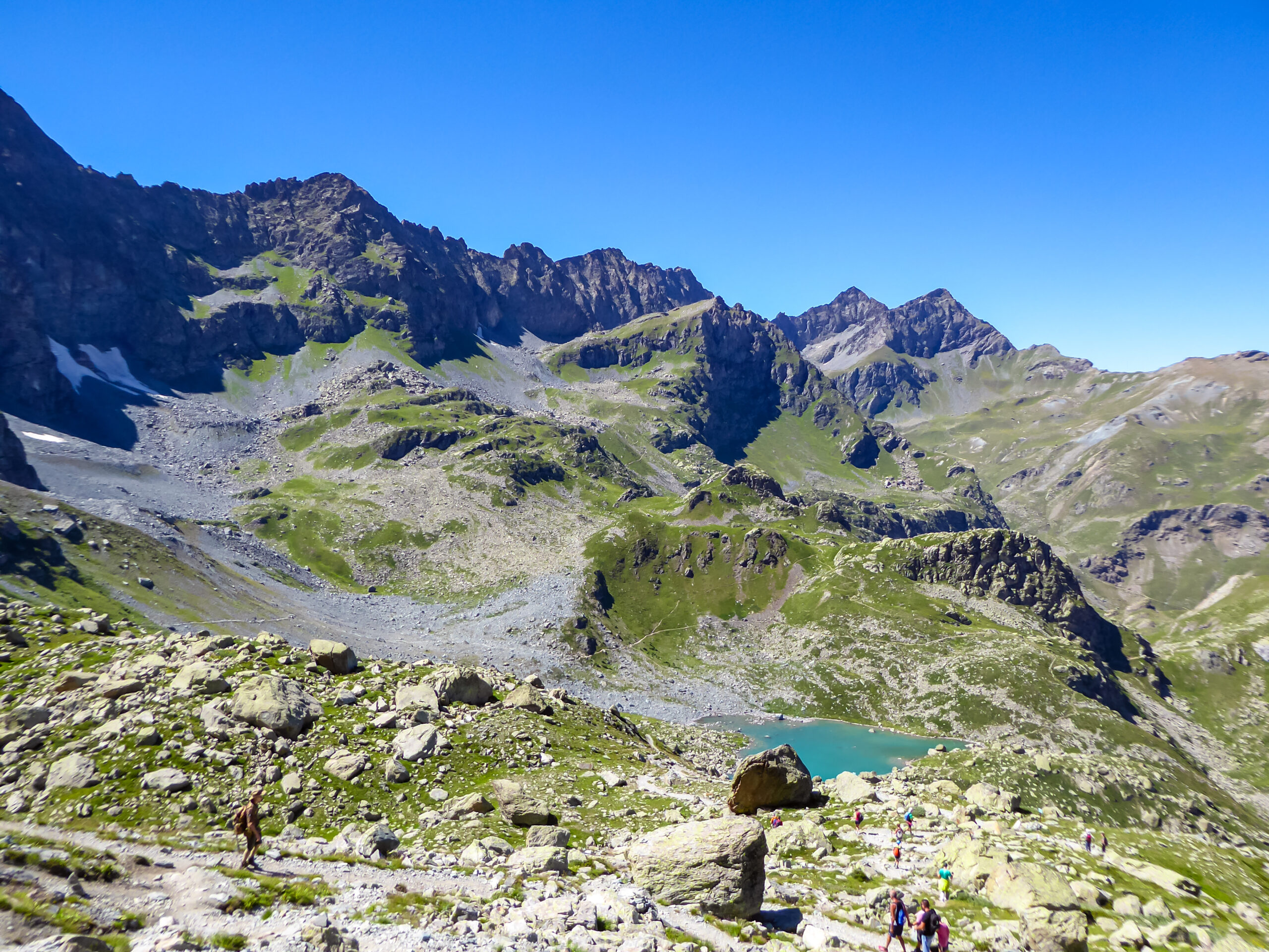
Monte Viso holds unique cultural and geographic significance as the source of the Po River — Italy’s longest river at 652 km. The Po springs forth at Pian del Re (2,020m) at the head of the Po Valley. The source water emerges between two large boulders just minutes from the parking lot used by climbers. The Po River shaped much of Italian history — its valley contained Roman cities, medieval principalities, and modern Italy’s industrial heartland. Standing at the Po’s source while looking up at Monte Viso represents a culturally significant moment for many Italian climbers. The source location is marked and easily accessible — a brief side trip from the main climbing approach. Few major Alpine peaks combine genuine alpine climbing with culturally significant river source access.
The Ideal Mont Blanc / Matterhorn Preparation
Monte Viso provides ideal preparation for harder Alpine objectives. The mountain delivers a physically challenging summit day with moderately technical but long and sustained scrambling — without the technical climbing demands or extreme altitude exposure of Mont Blanc or the Matterhorn. Climbers building toward those harder peaks benefit from Monte Viso experience. The benefits include the rifugio system, the multi-day alpine approach pattern, the via ferrata equipment use, and the high-alpine summit day rhythm. Route-finding through complex terrain also transfers. Many UK-based and international Alpine guide services explicitly position Monte Viso as Mont Blanc preparation. The peak delivers a major alpine summit climb in its own right while building the foundation for harder objectives.
The Cottian Alps connection across Italy and France. The Cottian Alps (Italian: Alpi Cozie; French: Alpes Cottiennes) form a major portion of the southwestern Alps, straddling the border between Piedmont in Italy and the Auvergne-Rhône-Alpes and Provence-Alpes-Côte d’Azur regions of France. The range stretches from the Maritime Alps in the south to the Graian Alps in the north. Monte Viso is the highest peak of the entire range, with its summit on the Italian side just feet from the French border. The watershed creates important hydrological significance. The eastern slopes drain east into the Po River and ultimately the Adriatic Sea. Meanwhile, the western slopes drain west into the Guil and Durance rivers and ultimately the Mediterranean. Climbers can choose Italian or French approach valleys depending on which side they want to experience. Most climbing parties use the Italian Pian del Re approach since the Rifugio Quintino Sella is the most established high mountain hut. However, ascents from the French side via the Vallon des Forannes are also possible. These appeal to parties seeking less-traveled approaches.
Who Should Climb Monte Viso?
Monte Viso sits in a specific position in Alpine mountaineering progression. The peak is more demanding than introductory alpine objectives but doesn’t reach the technical difficulty of harder 4,000m Alpine peaks. Honest pre-trip self-assessment matters, particularly regarding scrambling competence at altitude and basic via ferrata experience.
Monte Viso Is Appropriate For:
Climbers with prior alpine scrambling experience. Climbers who’ve completed peaks like the Hornli Hut approach on the Matterhorn, easier Alpine 3,000m peaks, or sustained Class 3 scrambling routes have the technical foundation. Monte Viso demands UIAA III scrambling — comparable to Colorado’s harder Class 3 fourteeners but with via ferrata sections.
Climbers preparing for Mont Blanc or the Matterhorn. Monte Viso provides ideal preparation for these harder Alpine objectives. Many UK and international guide services explicitly position Monte Viso as Mont Blanc training. The combination of alpine environment, via ferrata equipment use, and sustained summit day exactly matches what harder Alpine peaks demand.
Climbers with good fitness. The 8-12 hour summit day from Rifugio Quintino Sella plus the 2-3 hour approach to the rifugio demands serious mountain fitness. Climbers comfortable with 14+ hour total days have the foundation.
Via ferrata experienced climbers. The route includes chained sections that require via ferrata-style movement. Climbers who’ve done European via ferrate or used fixed-rope sections on other Alpine peaks have the relevant experience. First-time via ferrata users can manage the route with a guide.
Climbers wanting Italian Alpine culture exposure. Italian rifugio culture, IFMGA Italian guide services, and the Piedmontese mountain experience all differ meaningfully from Chamonix-style Alpine climbing. Climbers seeking Italian Alpine culture find Monte Viso ideal.
First-time Alpine climbers with a guide. Unlike many harder Alpine objectives, Monte Viso can be a reasonable first major Alpine summit for fit climbers willing to hire an IFMGA-certified guide. The guide manages the via ferrata, route-finding, and rope work that less experienced climbers couldn’t handle alone.
Monte Viso Is Not Appropriate For:
Beginners without alpine experience. Despite being approachable with a guide, Monte Viso isn’t a true beginner peak. Climbers without prior scrambling, basic crampon experience, or high-altitude exposure should build skills on easier objectives first.
Climbers seeking only easy walks. Monte Viso isn’t a hiking peak in the strict sense. The UIAA III scrambling, via ferrata sections, and exposed ridge climbing aren’t suitable for climbers expecting trail walking.
Climbers without basic fitness. The long summit day combined with the approach demands serious mountain fitness. Climbers without 8+ hour day-hike capability face elevated difficulty.
Climbers on rigid weather schedules. Italian Alpine weather can change rapidly. Climbers locked into specific summit dates face pressure to climb in marginal conditions. Build buffer days into the schedule.
Solo first-time climbers. First-time Monte Viso climbers should not attempt the route solo. The route-finding complexity, via ferrata sections, and exposure require either prior experience or guide support.
Where Monte Viso Fits in Your Alpine Progression
| Stage | Peak / Experience | Difficulty | What it builds |
|---|---|---|---|
| Foundation | Cathedral Peak (Slovenia), simple Alpine 3,000m peaks | F to PD- | Alpine environment exposure; basic mountain fitness |
| First scrambling peaks | Italian Dolomites via ferrata, Gran Paradiso normal route | F+ to PD | Via ferrata equipment use; basic alpine scrambling |
| Monte Viso step | Monte Viso via Via Mathews | PD+ / UIAA III | Sustained alpine scrambling; via ferrata + snowfield sections; major prominent summit |
| 4,000m introductions | Gran Paradiso, Mont Blanc, Allalin | PD to AD- | First 4,000m peaks; glacier travel; rope team work |
| Classic 4,000m peaks | Matterhorn Hornli Ridge, Eiger Mittellegi | AD+ to D | Sustained technical climbing at altitude |
| Hard Alpine peaks | Grandes Jorasses, Eiger North Face | D+ to ED | Elite alpine climbing |
| Beyond Alpine | Himalayan 6,000-7,000m peaks | Various | Where Alpine lessons apply at extreme altitude |
The Standard Routes Up Monte Viso
Three principal routes exist on Monte Viso. The South Face (Via Mathews) handles approximately 85% of climbers as the standard line. The East Route provides a slightly more demanding alternative. The North Face and harder technical routes are reserved for experienced alpinists.
| Route | Side | Difficulty | Total time | Usage |
|---|---|---|---|---|
| South Face / Via Mathews (Standard) | South | PD+ / UIAA III | 8-12 hrs summit day | ~85% of climbers |
| East Route | East | AD- / UIAA III+ | 10-14 hrs summit day | ~10% of climbers |
| North Face routes (multiple) | North | D+ to ED | Variable | ~5% of climbers |
Route 1: South Face — Via Mathews (Standard — 85% of climbers)
The South Face — Via Mathews — is the standard climbing line on Monte Viso. The route ascends from Rifugio Quintino Sella (2,640m) through the Passo delle Sagnette (2,991m). Then it continues up the south face with UIAA III rock passages, via ferrata chains, and snowfield sections. The summit reaches 3,841m. The route is the same line followed by William Mathews and his guide Michel Croz during the 1861 first ascent, with via ferrata installations and route markings added in subsequent decades. Most parties spend the night at Rifugio Quintino Sella before the summit attempt.
The Full Route Progression
- Day 1 — Approach to Rifugio Quintino Sella (2,640m): Drive from Saluzzo via the Po Valley road to Pian del Re (2,020m). Large car park at trailhead. The trail follows the Po River source on a beautiful path through the valley end. Approach takes 2-3 hours covering approximately 4 km and 620m elevation gain. Most parties arrive at the rifugio mid-afternoon, settle into bunks, and have early dinner.
- Pian del Re — Source of the Po: At the trailhead, take 10 minutes to walk almost level to two large boulders where the official source of the Po River is located. The source spring emerges from the boulders and forms the beginning of Italy’s longest river. Culturally significant brief detour before beginning the ascent.
- Rifugio Quintino Sella (2,640m): Standard high camp. Italian alpine club (CAI) hut with full meal service, bunk room accommodation, and rifugio culture. Reservations essential during peak season. CAI members receive significant discounts. Most parties go to bed early for pre-dawn departure.
- Day 2 — Summit attempt: Pre-dawn departure from rifugio (typically 04:00-05:00). Headlamps essential for the early climbing.
- Climb to Passo delle Sagnette (2,640-2,991m): Approximately 1.5 hours from rifugio to the pass. The trail climbs east up moraine and snowfield terrain. The pass marks the entry to the upper south face climbing.
- The via ferrata chains (2,991-3,300m): The route’s signature technical feature — chains and cables installed in the via ferrata style for protection on the steeper sections. Climbers use harness and via ferrata lanyards for protection on the chains.
- South face scrambling (3,300-3,700m): Sustained UIAA III rock passages with route-finding through gullies and ledges. The climbing is moderate but exposed — careful movement essential. Test holds on the rock but Monte Viso’s rock is generally more solid than the Maroon Bells character.
- Final summit climbing (3,700-3,841m): The final 150 vertical meters demand sustained focus at altitude. Continued UIAA III scrambling to the summit. Snowfield sections may persist into summer depending on snow year.
- Summit at 3,841m: Monte Viso summit. Extraordinary 360-degree panorama — Mont Blanc to the north, Maritime Alps to the south, Po Valley to the east, French Queyras to the west. Stay 30-45 minutes for photos and absorption. Most parties leave summit by 12:00-13:00 to manage afternoon weather.
- Descent: Reverse the route exactly. Down-climbing the UIAA III sections demands focus. The chains are useful for protected descent. Return to Rifugio Quintino Sella by mid-afternoon. Total summit day: 8-12 hours.
- Day 3 — Return to Pian del Re: Descend from rifugio to Pian del Re car park. 1.5-2 hours. Drive to Saluzzo or onward destination.
Strengths
- Most iconic isolated Alpine pyramid
- Historic 1861 first ascent route
- Source of the Po River cultural significance
- Rifugio Quintino Sella hut culture
- Ideal Mont Blanc / Matterhorn preparation
- 360-degree summit panorama
Considerations
- UIAA III demands real climbing competence
- Via ferrata sections require equipment
- Long 8-12 hour summit day
- Italian-language rifugio environment
- Possible snow/ice even in summer
- 2-3 day trip commitment
Route 2: East Route (Slightly Harder Alternative — 10% of climbers)
The East Route ascends Monte Viso from the eastern side, typically approached from Rifugio Vallanta (2,450m) — accessed from the village of Castello in the upper Valle Varaita. The route is slightly more demanding than the Via Mathews south face standard, with sustained UIAA III+ climbing and longer time on technical terrain. Total summit day runs 10-14 hours from the rifugio. The East Route appeals to climbers seeking a more challenging line or wanting to avoid the more crowded south face during peak season. Italian guide services occasionally offer this route as an alternative to the standard. The route requires similar via ferrata equipment to the standard line with somewhat more sustained technical climbing.
Route 3: North Face Routes (Technical Alpine — 5% of climbers)
The dramatic north face of Monte Viso presents some of the most demanding technical climbing in the southern Cottian Alps. Multiple route variations exist at French alpine grades D+ through ED. The face features sustained ice climbing, mixed terrain, and serious objective hazards from falling rock and ice. Notable historic ascents include first ascents in the 1960s-1970s by Italian and French alpine teams. Commercial guiding doesn’t typically operate on north face routes. Climbers attempting these lines are typically experienced alpinists seeking the most demanding objectives the mountain offers. The north face represents Monte Viso at its most technically demanding, well beyond standard summit-route objectives. Few documented modern ascents exist — the face attracts serious parties but defeats most attempts.
Monte Viso Climbing History: From 1861 to 2026
Monte Viso held cultural significance in the Po Valley region for centuries before modern climbing. The Roman writer Virgil mentioned the mountain in his Aeneid (29-19 BCE), identifying it as the source of the Po (then called the Eridanus). Medieval Italian poets including Dante Alighieri referenced Monte Viso. The mountain’s distinctive isolated pyramidal shape made it a recognizable landmark visible across the Piedmont plain. Local Piedmontese populations called the peak “Viso” (face) in Occitan and Piedmontese dialects — referencing the mountain’s prominent profile.
In 1480, the Marquis of Saluzzo constructed the Buco di Viso (Hole of Viso) — a 75-meter-long tunnel through the Cottian Alps at 2,882m elevation, just below Monte Viso. The tunnel allowed mule trains to cross from Piedmont to France carrying salt, wine, and trade goods. The Buco di Viso is considered one of the oldest mountain tunnels in the world and remains intact today. The structure represents Monte Viso’s place in late medieval trade history and the mountain’s recognized strategic importance. The tunnel can be visited today by hikers traversing the Cottian Alps ridge.
The 1850s marked the systematic beginning of European Alpine climbing. The Alpine Club (London) was founded in 1857 — the world’s first mountaineering club. William Mathews became one of the founding members. The “Golden Age of Alpinism” — the period from approximately 1854 to 1865 when most major Alpine peaks were first climbed — coincided with growing Victorian-era English interest in mountain adventure. Monte Viso was among the prominent Alpine peaks remaining unclimbed at the start of the era, drawing increasing interest from British climbers.
The first ascent of Monte Viso was completed on August 30, 1861 by William Mathews and Frederic Jacomb of England with their Chamonix guide Michel Croz. The party climbed the south face route that became the modern Via Mathews. The achievement came during the heart of the Golden Age of Alpinism. Mathews was a founder of the Alpine Club (London) — his Monte Viso ascent was part of the systematic English-led climbing of major Alpine peaks during the era. Croz would later die on the Matterhorn during Whymper’s 1865 first ascent disaster, becoming one of the most famous Alpine guides of the era. The Via Mathews route name preserves Mathews’ first ascent legacy.
The Club Alpino Italiano (CAI) was founded in 1863 in Turin — Italy’s first mountaineering organization, just two years after Monte Viso’s first ascent. The CAI established the rifugio system that became central to Italian Alpine climbing. The Rifugio Quintino Sella (named for the CAI’s founder and Italian statesman Quintino Sella) was eventually established on Monte Viso’s south face, providing the standard high camp for subsequent ascents. The CAI continues today as Italy’s primary mountaineering organization with hundreds of mountain huts across the Italian Alps.
Through the late 19th century, Monte Viso saw growing climbing traffic from British, Italian, and French parties. The Via Mathews became established as the standard route. The Rifugio Quintino Sella was built to support climbing operations. Various alternative routes were explored on the east, north, and west faces. The mountain became firmly established in Alpine climbing literature alongside Mont Blanc, the Matterhorn, and other Golden Age peaks. Italian alpine culture began centering on the peak with regional clubs organizing systematic ascents.
Through the early 20th century, Monte Viso became deeply embedded in Italian alpine tradition. Local Piedmontese climbers developed extensive route knowledge and historical climbing records. The CAI Cuneo and Saluzzo sections organized regular expeditions. The north face routes were established by Italian alpine teams. The Buco di Viso medieval tunnel was rediscovered and preserved as a cultural heritage site. Monte Viso featured prominently in Italian alpine literature and climbing journals.
The 1960s-1980s brought modern technical climbing to Monte Viso. Italian and French alpine teams established harder routes on the north face and east face. The north face received its first major technical ascents during this era. Italian climbing legends including Giancarlo Grassi pioneered new lines. The rifugio system was modernized with improved access and services. The Cottian Alps became firmly established as one of Italy’s premier alpine climbing regions.
The Monviso Biosphere Reserve was established under UNESCO’s Man and the Biosphere Programme (MAB) in 2013, recognizing the area’s ecological and cultural significance. The reserve covers approximately 1,135 km² spanning Italy and France, protecting both the natural alpine environment and the cultural heritage of the surrounding valleys. The UNESCO designation reflects Monte Viso’s place not just as a climbing destination but as a culturally and ecologically significant mountain region. The Buco di Viso medieval tunnel and the Po River source are both protected under the biosphere reserve framework.
The 2000s brought systematic commercial guiding to Monte Viso. IFMGA-certified Italian guides established programs targeting both Italian domestic climbers and international visitors. UK-based operators (High Mountain Guides and similar) added Monte Viso to their Alpine portfolios, often as Mont Blanc preparation. The Rifugio Quintino Sella was modernized with improved bunk accommodation and meal services. Annual climbing traffic grew significantly, with the mountain becoming established as a major commercial Alpine objective.
In 2013, the Monviso Transboundary Biosphere Reserve was officially established by UNESCO, recognizing the area’s status as a shared Italian-French natural and cultural heritage. The reserve includes Monte Viso itself and the surrounding valleys on both sides of the border. The designation enhanced protection for the alpine environment while supporting sustainable tourism including climbing. The biosphere reserve management coordinates conservation efforts across the international border — significant for a region that historically had limited cross-border cooperation.
The COVID-19 pandemic initially affected Monte Viso climbing in 2020, with Italian alpine tourism reduced during travel restrictions. The 2021 and 2022 seasons saw return to typical visitor numbers as European travel patterns normalized. Italian rifugios adapted with health protocols. The Rifugio Quintino Sella implemented booking systems and capacity management that have continued in modified form. The pandemic’s effects on Italian alpine tourism were less severe than for Himalayan climbing destinations.
The 2023-2025 climbing seasons saw continued strong demand for Monte Viso among Italian and international climbers. IFMGA Italian guide services run regular programs throughout July and August. International operators continue offering Monte Viso as Mont Blanc preparation. The Rifugio Quintino Sella operates at capacity during peak weeks — reservations essential. 2026 climbing season is currently active with the late June through mid-September window. Italian Alpine Club discounts continue, with reciprocal arrangements for international Alpine Club members. The mountain continues serving its role as one of the Alps’ most distinctive isolated pyramidal peaks and ideal preparation for harder Alpine objectives.
The Golden Age of Alpinism: Monte Viso’s 1861 Historical Context
Monte Viso occupies a specific position in the Golden Age of Alpinism — the seminal 1854-1865 period when most major Alpine peaks were first climbed. Understanding the Golden Age context shapes how serious climbers approach Monte Viso within broader European mountaineering history.
What the Golden Age Means
The Golden Age of Alpinism is the period from roughly 1854 to 1865. It began with the Wetterhorn first ascent and ended with the Matterhorn first ascent disaster. British climbers and their Alpine guides systematically completed first ascents of the major peaks of the European Alps during this time. The era saw the founding of the Alpine Club (London, 1857) — the world’s first mountaineering club. British climbers including Edward Whymper, Leslie Stephen, John Tyndall, William Mathews, and others established the foundations of modern mountaineering. The era ended with the 1865 Matterhorn disaster that claimed four lives — including Monte Viso first ascent guide Michel Croz — and prompted widespread reflection on mountain risk.
Monte Viso’s Place in the Golden Age
| Year | Peak | First Ascent Notes |
|---|---|---|
| 1854 | Wetterhorn (3,692m) | Alfred Wills — considered start of Golden Age |
| 1855 | Monte Rosa (4,634m) | Charles Hudson, John Birkbeck, others |
| 1858 | Eiger (3,967m) | Charles Barrington with guides |
| 1859 | Aletschhorn (4,193m) | Francis Tuckett with guides |
| 1861 | Monte Viso (3,841m) | William Mathews, Frederic Jacomb, Michel Croz |
| 1862 | Dent Blanche (4,357m) | Thomas Kennedy, William Wigram, others |
| 1864 | Barre des Écrins (4,102m) | Edward Whymper, Adolphus Moore, Horace Walker |
| 1865 | Matterhorn (4,478m) | Edward Whymper expedition — Golden Age ends with disaster |
The Michel Croz Connection
Monte Viso’s first ascent guide Michel Croz remains one of the most famous Alpine guides of the Golden Age. Born in Chamonix in 1830, Croz became the most sought-after guide of his era. He climbed with Mathews on Monte Viso in 1861. Later he guided Edward Whymper to multiple first ascents including the Grandes Jorasses, the Barre des Écrins, and the Aiguille Verte. Croz died on July 14, 1865 during the Matterhorn first ascent disaster, falling 1,000 meters with three other party members. The 2,800-meter Croz Spur on the Grandes Jorasses is named in his honor. Climbing the Via Mathews route on Monte Viso means following the path of one of mountaineering’s most legendary guides during one of his most significant ascents.
The Alpine Club London and Monte Viso. The Alpine Club, founded in London in 1857, was the world’s first mountaineering club. William Mathews was among the founding members — and his 1861 Monte Viso first ascent represented one of the Alpine Club’s significant early achievements. The club’s membership during the Golden Age included most of the leading British climbers of the era. The club’s “Alpine Journal” (founded 1863) documented many of the era’s climbs including Mathews’ Monte Viso ascent. Today the Alpine Club continues with reciprocal arrangements with the Italian Alpine Club (CAI) — allowing AC members to use CAI rifugios including Rifugio Quintino Sella at member rates. Climbers interested in mountaineering history find Monte Viso particularly resonant given the peak’s place in early Alpine Club achievement.
Monte Viso Summit Day Timeline: Hour-by-Hour from Rifugio Quintino Sella
Summit day on Monte Viso typically runs 8-12 hours round trip from Rifugio Quintino Sella (2,640m) to the summit at 3,841m and back. Strong, well-conditioned teams complete the round trip in 8-10 hours. Slower parties may take 12-14 hours. The combination of via ferrata sections, UIAA III scrambling, snowfield travel, and 1,200 meters of elevation gain creates a demanding but achievable summit day.
Standard Monte Viso Summit Day — Rifugio Quintino Sella (2,640m) to Summit (3,841m) and Return
Which Monte Viso Approach Fits Your Situation?
The choice on Monte Viso involves operator selection, route choice, and program structure. Use this matrix to match yourself.
Match Yourself to a Monte Viso Approach
When to Climb Monte Viso: Season-by-Season Analysis
Mid-July to Mid-August: Peak Season
The prime Monte Viso climbing window. The route is generally snow-free except for occasional summit snowfields, the Rifugio Quintino Sella operates at full capacity, and trail conditions are excellent. Trade-off: rifugio crowds peak during weekend days — weekday attempts offer significantly fewer climbers. The via ferrata chains can become congested during peak weeks. Most successful Monte Viso summits occur during this window. Weather is generally most stable.
Late August to Early September: Sweet Spot
Many experienced Italian climbers consider this the optimal Monte Viso window. Conditions remain excellent with somewhat less afternoon weather instability. Crowds drop noticeably from peak summer. Rifugio reservations easier to obtain. Daylight remains adequate for the long summit day. Photography conditions are excellent with stable evening alpenglow.
Mid-September to Early October: Autumn Window
The autumn window brings stable weather, golden larch colors in the lower approach valleys, and significantly reduced crowds. Temperatures drop noticeably — start with warmer layers than summer. Early October may bring first snow on the upper mountain that complicates the via ferrata sections. The Rifugio Quintino Sella typically closes for the season in mid-September depending on weather. Climbers attempting after rifugio closure must use bivouac shelters.
Late June to Early July: Early Season
Early July can have remnant snow on the upper south face and around Passo delle Sagnette. Climbers attempting in this window may need ice axe and crampons for snow-packed sections. The lower approach to the rifugio is generally clear. Daylight is at its longest — useful for the demanding summit day. The Rifugio Quintino Sella typically opens around mid-June depending on snow conditions.
October-May: Off-Season
Winter ascents of Monte Viso become extreme alpine mountaineering objectives requiring full winter mountaineering experience. The Rifugio Quintino Sella closes for the season. Avalanche risk in the Cottian Alps is genuine throughout winter. The via ferrata sections become ice-and-snow climbing requiring different technique. Some experienced ski mountaineers approach Monte Viso during stable spring conditions (April-May) for combined ski/climbing ascents, but the summit ridge remains a technical climbing objective. Most parties don’t attempt Monte Viso in winter.
Climbing Monte Viso in 2026: Cost Breakdown (EUR)
Monte Viso offers strong value among Alpine climbing destinations. Italian alpine pricing is more affordable than French (Chamonix area) operators, with established rifugio infrastructure keeping accommodation costs reasonable.
2026 Guided Expedition Pricing
| Operator Tier | 2026 Cost (EUR) | What’s Included |
|---|---|---|
| Italian IFMGA guide (2-day) | €700-€1,000 per person | Certified Italian guide, rifugio coordination, summit day; 2-3 climbers per guide |
| UK / international operator (3-day) | €1,200-€1,800 per person | High Mountain Guides UK tier; English-speaking guide, Chamonix start/finish, Mont Blanc Tunnel transfer |
| Private 1:1 or 1:2 guiding | €1,200-€1,800 per person | Dedicated guide attention, custom dates, flexible itinerary |
| Combined Monte Viso + Gran Paradiso | €1,500-€2,500 per person | 5-7 day program with both peaks; preparation for harder objectives |
| Mont Blanc preparation program | €1,800-€2,800 per person | Multi-week Alpine training with Monte Viso as preparation peak; combined with Mont Blanc attempt |
2026 Independent Trip Cost Breakdown
| Cost Component | 2026 Amount (EUR) | Notes |
|---|---|---|
| Pian del Re parking | €0-€10 | Currently free or modestly priced; large car park |
| Rifugio Quintino Sella (1 night) | €60-€80 | Half-board (bed, dinner, breakfast); CAI members 50% discount |
| Rifugio additional nights | €60-€80/night | For weather flexibility or post-summit recovery |
| Saluzzo / Crissolo accommodation | €60-€120/night | B&Bs, hotels in gateway towns; pre/post trip |
| Restaurant meals (Saluzzo/Crissolo) | €20-€40/day | Italian cuisine; piedmontese specialties |
| Car rental from Turin | €40-€80/day | ~3 days typical for trip |
| Fuel (Turin to Pian del Re) | €30-€60 | ~200 km round trip |
| Personal climbing gear (if buying) | €0-€800 | Helmet, harness, via ferrata lanyard, crampons, ice axe |
| Via ferrata equipment rental | €15-€25/day | Available in Saluzzo or from operators |
| International flights to Turin | €100-€400 | Variable by departure city; Turin TRN airport |
| Travel insurance (alpine) | €30-€100 | Should cover Italian alpine rescue |
| Total 3-day independent budget | €400-€900 | Excluding flights and existing gear |
| Total trip including flights | €600-€1,500 | Independent climbing with prior gear |
The Italian Alpine Club (CAI) and reciprocal arrangements. The Club Alpino Italiano (CAI) offers significant rifugio discounts to members — typically 50% off accommodation rates at affiliated huts including Rifugio Quintino Sella. CAI membership costs approximately €45-€55/year for full members. International climbers benefit from reciprocal arrangements: Alpine Club London, American Alpine Club, Austrian Alpine Club, Swiss Alpine Club, and other international clubs have agreements that grant member-rate access to CAI rifugios. The reciprocal arrangement is a major financial benefit for climbers planning multi-day Italian Alpine trips — a 2-3 night rifugio stay saves €60-€120 with member rates. International climbers planning Italian Alpine climbing should join a reciprocal club well before their trip. The arrangement also extends to French Alpine Club (CAF) and German Alpine Club (DAV) huts, making membership particularly valuable for cross-border Alpine climbing.
Gear Checklist for Monte Viso
Monte Viso gear requirements combine alpine scrambling equipment with via ferrata kit for the chained sections. The UIAA III standard route demands sturdier kit than introductory alpine objectives but doesn’t require full technical climbing equipment. The 2-3 day trip duration with rifugio overnight means climbers pack lighter than for tent-based expeditions.
Technical Climbing Gear
- Climbing helmet (REQUIRED) — non-negotiable for the via ferrata sections and exposed scrambling
- Climbing harness — alpine harness for via ferrata clipping; lightweight design preferred
- Via ferrata lanyard set — essential for the chained sections; energy-absorbing model required for safety
- Crampons — 12-point general mountaineering crampons for snowfield sections — see our Crampons Buyer’s Guide
- Ice axe — straight-shaft general mountaineering axe — see our Ice Axe Guide
- Mountaineering boots — B2 boots compatible with semi-automatic crampons; sturdy ankle support
- 30m rope (party-dependent) — guides typically carry rope; independent parties may bring rope for security
- Locking carabiners (3-4)
- Slings/runners (2-3)
- Belay/rappel device — for any roped sections
Clothing System
- Base layer top and bottom — merino or synthetic; pre-dawn temperatures cold even in summer
- Trekking pants — quick-drying synthetic; convertible pants useful for warm afternoon descent
- Soft shell pants — for cooler conditions and via ferrata sections
- Mid-layer fleece or light insulated jacket — for cool starts and summit stops
- Insulated jacket — for summit stops; down or synthetic options
- Hardshell jacket — Gore-Tex or equivalent; weather protection essential
- Hardshell pants — for wet conditions or wind
- Warm hat / beanie
- Sun hat or visor
- Light gloves and warm gloves
- Mountaineering socks (2 pairs) — merino wool
Pack & Rifugio
- 30-40L summit pack — for summit day from rifugio
- Trekking poles (optional) — useful for the approach and descent on moraine
- Gaiters — for snowfield sections
- Rifugio essentials: sleeping bag liner (rifugio provides bedding); personal toiletries; earplugs (rifugio dormitories can be noisy); slippers/sandals (mountain hut etiquette)
- Cash for rifugio (EUR) — many rifugios cash-only or limited card service; budget for meals and drinks
Food, Water, and Safety
- Water capacity 2-3L for summit day — limited water on upper route
- Summit day snacks (energy bars, gels)
- Lunch food — most rifugios pack lunch for an additional charge
- Sunscreen SPF 50+ and lip balm with SPF
- Glacier glasses or quality sunglasses (Cat 3-4)
- Personal first aid kit — blisters, ibuprofen, basic supplies
- Headlamp with spare batteries — ESSENTIAL for pre-dawn 04:00 starts
- Emergency bivy — for unexpected weather or injury
- Satellite communicator or PLB — STRONGLY RECOMMENDED for backcountry sections
- Map and compass — for general route awareness
- GPS with route (Caltopo or Gaia) — recommended for route-finding
- Travel insurance documentation — should cover alpine rescue
- Passport for international climbers
Frequently Asked Questions About Climbing Monte Viso
How tall is Monte Viso and where is it located?
Monte Viso (also called Monviso) rises to 3,841 meters (12,602 feet) in the Cottian Alps of Piedmont, Italy. The coordinates are 44.6675°N, 7.0917°E. The mountain is the highest peak of the entire Cottian Alps range and the highest mountain entirely within Piedmont. It sits on the Italian-French border watershed, with its summit less than two miles from the French Hautes-Alpes département. The peak has 2,062 meters of prominence — ranking 10th in the Alps for prominence. Its distinctive isolated pyramidal shape rises above surrounding lesser peaks. The mountain is the source of the Po River — Italy’s longest river — which begins at Pian del Re (2,020m).
How difficult is climbing Monte Viso?
Monte Viso’s standard South Face route (Via Mathews) is rated UIAA III — moderate scrambling with via ferrata sections and short rock passages that don’t exceed grade III on the UIAA scale. The climb isn’t pure mountaineering but rather a mixed scrambling tour on easy rock with snowfields. The route shouldn’t be taken lightly due to the high alpine environment and possible presence of snow or ice even in summer. The climb is moderately technical but long and sustained. Climbers typically complete the ascent over 2-3 days with overnight at Rifugio Quintino Sella. High fitness level is required.
What’s the standard route up Monte Viso?
The standard route up Monte Viso is the South Face (Via Mathews) from Rifugio Quintino Sella. Climbers approach from Saluzzo via the Po Valley to Pian del Re (2,020m), where there is a large car park. From Pian del Re, the trail follows the Po River source up to Rifugio Quintino Sella (2,640m) — approximately 2-3 hours hiking. Most parties spend the night at the rifugio before the summit attempt. Summit day begins pre-dawn from the rifugio. Climbers tackle south face scrambles with via ferrata chains through the Passo delle Sagnette (2,991m). Then they continue up the south face with UIAA III rock passages and snowfields to the summit at 3,841m. Total summit day is 8-12 hours round trip.
When is the best time to climb Monte Viso?
The Monte Viso climbing season runs from late June through mid-September, with the optimal window being mid-July through August. July and August represent peak Alpine season with the most stable weather, fully operational rifugio infrastructure, and reliable route conditions. The route can have remnant snow in early July. September brings cooler temperatures, more stable weather, and significantly reduced crowds. Early October can bring first snow that increases technical difficulty significantly. Afternoon thunderstorms are common — climbers should plan to summit by early afternoon. Winter ascents are reserved for experienced alpinists due to extreme conditions.
How much does climbing Monte Viso cost in 2026?
Climbing Monte Viso is affordable by Alpine peak standards. Independent climbers should budget €60-€120 per day including Rifugio Quintino Sella accommodation (typically €60-€80 per night with half-board, CAI members receive discounts). The Pian del Re parking is currently free or modestly priced. Guided ascents from IFMGA-certified Italian guides run €700-€1,000 per person for the standard 2-day program. International operators offer 3-day programs from Chamonix for €1,200-€1,800 per person. Private 1:1 guiding runs €1,200-€1,800. Total trip budget including international flights typically runs €1,500-€2,500 for guided climbers.
Who first climbed Monte Viso?
Monte Viso was first climbed on August 30, 1861 by William Mathews and Frederic Jacomb of England with their Chamonix guide Michel Croz. The ascent came during the heart of the “Golden Age of Alpinism” — the 1854-1865 period when British climbers systematically completed first ascents of the major Alpine peaks. Mathews was a founder of the Alpine Club (London) in 1857. The standard route on Monte Viso is still called “Via Mathews” after the first ascender. Michel Croz became one of the most famous Alpine guides of the era. He later died on July 14, 1865 during Edward Whymper’s Matterhorn first ascent disaster. The event remains one of mountaineering’s most famous tragedies.
What’s the connection to the Po River?
Monte Viso is the source of the Po River — Italy’s longest river at 652 km. The Po springs forth at Pian del Re (2,020m) at the head of the Po Valley. The source water emerges between two large boulders just minutes from the parking lot used by climbers. The Po River shaped much of Italian history — its valley contained Roman cities, medieval principalities, and modern Italy’s industrial heartland. Standing at the Po’s source while looking up at Monte Viso represents a culturally significant moment for many Italian climbers. The source location is marked and easily accessible — a brief side trip from the main climbing approach.
Is Monte Viso a good Mont Blanc preparation peak?
Yes — Monte Viso is widely considered ideal preparation for Mont Blanc and the Matterhorn. The mountain delivers a physically challenging summit day with moderately technical but long and sustained scrambling — without the technical climbing demands or extreme altitude exposure of harder Alpine objectives. The combination of alpine environment, via ferrata equipment use, multi-day rifugio approach pattern, and high-alpine summit day rhythm directly transfers to Mont Blanc preparation. Many UK and international guide services explicitly position Monte Viso as Mont Blanc training. Climbers building toward Mont Blanc or the Matterhorn benefit significantly from Monte Viso experience as a stepping stone peak.
What’s the Rifugio Quintino Sella like?
Rifugio Quintino Sella is the standard high mountain hut for Monte Viso climbers, located at 2,640m on the south side of the mountain. The hut is operated by the Italian Alpine Club (CAI) and provides bunk room accommodation with half-board (dinner and breakfast included in standard rates). Typical rates are €60-€80 per night, with CAI members receiving approximately 50% discounts. The rifugio operates from mid-June through mid-September depending on weather. Reservations are essential during peak season — book 2-3 months ahead for July/August dates. The hut serves traditional Piedmontese cuisine and provides Italian Alpine culture experience. International alpine club members benefit from reciprocal discount arrangements.
Do I need via ferrata equipment for Monte Viso?
Yes — via ferrata equipment is essential for the standard South Face (Via Mathews) route. The route includes chains and cables installed in the via ferrata style on the steeper sections above the Passo delle Sagnette. Climbers need a harness and via ferrata lanyard set (energy-absorbing model) to clip into the chains for protection. The equipment can be rented in Saluzzo or obtained from your guide if booking guided. The via ferrata sections aren’t extremely difficult but require the equipment for safety. Helmets are also non-negotiable due to potential rockfall and the protected nature of the climbing. The via ferrata aspect makes Monte Viso somewhat distinctive among Alpine standard routes.
Monte Viso Planning Resources
Sources & Further Reading
- Outdooractive — Monviso or Monte Viso 3841m Normal Route Over South Face (February 2026)
- UKClimbing — Monte Viso Logbook reference (May 2026)
- Explore-Share — Monte Viso Climbing Trips: Guided Ascents and Expeditions
- SummitPost — Monte Viso Normal Route (South Face) climbing reference
- High Mountain Guides UK — Climb Monte Viso 3841m program (November 2024)
- Wikipedia — Monte Viso reference for elevation, geography, and first ascent
- Wikipedia — Cottian Alps reference for range geography
- John Biggar — Cottian Alps Ski Mountaineering and Monte Viso circuit tour
- Provence-Alpes-Côte d’Azur Tourism — Mount Viso (3841m) mountaineering and hiking
- Club Alpino Italiano (CAI) — Rifugio Quintino Sella information and reciprocal arrangements
- Alpine Club London — William Mathews 1861 first ascent documentation
- UNESCO Man and the Biosphere Programme — Monviso Transboundary Biosphere Reserve (2013)
Last updated: May 25, 2026. Next scheduled update: March 2027 (pre-season verification of Rifugio Quintino Sella rates, IFMGA Italian guide pricing, and Pian del Re access).
Planning an Alpine Climbing Trip?
Monte Viso is one of the Alps’ most distinctive isolated pyramidal peaks and ideal preparation for harder Alpine objectives. See our complete mountain guides for the broader European Alpine climbing picture, including Mont Blanc preparation peaks like the Italian Dolomites and Gran Paradiso.
View All Mountain Guides →Was this helpful?
🏔Related peaks nearby
🧭Explore & compare
Global Summit Guide is an independent mountaineering resource founded in 2026. The team combines first-hand trekking and climbing experience with in-depth research and professional health and nutrition review to help climbers choose objectives, prepare properly, and stay safe.
Health, altitude, and nutrition content is reviewed by Taylor Ludlow (Registered Nurse) and Brigg Hoopes (Nutritionist).
What We Don't Know Yet
Mountain information changes quickly. This box explains the limits of what this page can responsibly promise.
- Route conditions, trailhead access, crevasse exposure, stream crossings, and rescue access may vary from published planning guidance.
- Visa, passport, vaccination, border, insurance, and local transportation rules may change before your trip.
- Route conditions, snowpack, closures, and weather can change quickly after this page is updated.
- Permit rules, fees, quotas, and reservation windows may change between review cycles.
- Operator availability, pricing, guide ratios, and cancellation terms can change by season.
Verify current conditions with official land managers, guide services, local forecasts, and current route reports before booking or climbing.
Part of this Global Summit Guide cluster
Explore the complete Mountains guide for more context, routes, planning links, and related resources.
Mountaineering, rock and ice climbing, glacier travel, and high-altitude activity are inherently dangerous and can result in serious injury or death. The information on Global Summit Guide is provided for general informational and educational purposes only and is not a substitute for professional instruction, qualified guiding, proper equipment, or your own judgment and experience.
Route conditions, weather, snowpack, permits, regulations, and hazards change constantly and may differ from what is described here. Details may be incomplete, out of date, or contain errors. Always verify current information with local authorities, certified guides, and official sources before making any decision in the mountains.
Nothing on this site is medical, legal, or financial advice. Our fitness, acclimatization, altitude, and nutrition content is general in nature; consult a qualified physician before beginning any strenuous exercise program or exposing yourself to high altitude.
You are solely responsible for your own safety and decisions. To the fullest extent permitted by law, Global Summit Guide and its team accept no liability for any loss, injury, damage, or expense arising from use of, or reliance on, this information. By using this site you acknowledge these risks and accept these terms.
Some links on this site may be affiliate links. If you buy through them we may earn a small commission at no extra cost to you; this never affects our recommendations.
Global Summit Guide recommendation path
Next Best Mountain to Research
Use these recommendations to continue the right planning path instead of stopping on one page.
Use current permit, weather, route, and operator information before booking or climbing.