
Last updated May 28, 2026
Mount Kinabalu Complete Guide 2026 — The 4,095m Sabah Borneo Peak, Hugh Low’s 1851 First Ascent, Whitehead’s 1888 True Summit, World’s Highest Via Ferrata at 3,776m, the June 5, 2015 Earthquake Legacy, and the RM400 Sabah Parks Permit System
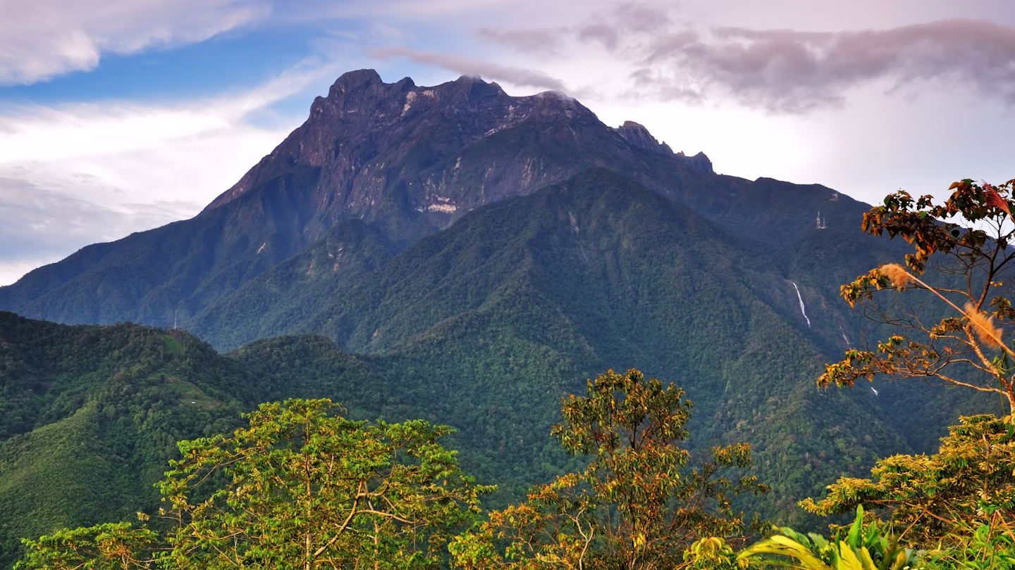
Mount Kinabalu rises 4,095 m (13,435 ft) in Sabah, Malaysian Borneo as the country’s highest peak and the tallest mountain between the Himalayas and New Guinea. Generally, the mountain combines genuine 4,000-meter altitude with non-technical terrain accessible to fit beginners — a rare combination among Southeast Asian peaks. Specifically, Kinabalu Park became Malaysia’s first UNESCO World Heritage Site in 2000 and also holds UNESCO Global Geopark and IUGS Geological Heritage Site status (October 2022). Notably, Hugh Low completed the first recorded ascent of the summit plateau in March 1851 with Dusun guide Lemaing of Kampung Kiau. John Whitehead reached the true summit (Low’s Peak) first in 1888. Lilian Gibbs became the first woman to summit in February 1910. The June 5, 2015 magnitude 6.0 earthquake killed 18 climbers and fundamentally reshaped the mountain’s infrastructure. The 2026 climb requires a RM400 international permit through sabapakeco.com, a mandatory licensed Turkish guide, and overnight at Panalaban Base Camp (3,270 m) before the pre-dawn summit push.
Mount Kinabalu rises 4,095 m in Sabah, Malaysian Borneo as the country’s highest peak and the tallest mountain between the Himalayas and New Guinea. Generally, the mountain holds an exceptional position in global mountaineering — Malaysia’s first UNESCO World Heritage Site, the world’s highest Via Ferrata at 3,776 m, and one of the few major peaks accessible to fit beginners with no technical climbing required. Specifically, Mount Kinabalu ranks as the 20th most prominent mountain on Earth and the third highest peak on any island globally, after Puncak Jaya (Papua) and Mauna Kea (Hawaii). Notably, indigenous Kadazan-Dusun peoples revere the mountain as Aki Nabalu — meaning Revered Place of the Dead.
This guide answers what hikers and climbers ask about Mount Kinabalu. How hard is the standard Ranau Trail compared to Kilimanjaro? What does the 2026 RM400 permit actually cover? Notably, we’ll cover several concrete topics. First, the March 1851 Hugh Low first ascent of the summit plateau with Dusun guide Lemaing of Kampung Kiau. Then the 1888 John Whitehead true summit ascent and 1910 Lilian Gibbs first female climb. Also four route options including the Ranau Summit Trail standard, Kota Belud Summit Trail alternative, and two Via Ferrata add-ons. Plus the June 5, 2015 magnitude 6.0 earthquake legacy and post-disaster trail reconstruction. Plus four cost tiers from RM1,629 budget DIY through RM5,500 ultra-premium 3D2N programs. Finally, seasonal planning for the March-September dry season window.
Mount Kinabalu At a Glance
| Specification | Value | Context |
|---|---|---|
| Summit elevation | 4,095 m / 13,435 ft | Low’s Peak · Malaysia’s highest |
| Local name | Gunung Kinabalu | From Aki Nabalu — “Revered Place of the Dead” |
| Location | Sabah, Malaysian Borneo | Crocker Range · Kinabalu Park |
| Coordinates | 6.08°N, 116.56°E | ~2 hours from Kota Kinabalu |
| Prominence rank | 20th in the world | Tallest between Himalayas and New Guinea |
| UNESCO status | World Heritage Site (2000) | Malaysia’s first · 25th anniversary Dec 2, 2025 |
| Geological status | IUGS Geological Heritage Site (Oct 2022) | Global Geopark · Neogene granite intrusion |
| First summit plateau ascent | March 1851 | Hugh Low + Lemaing of Kampung Kiau (Dusun guide) |
| First true summit ascent | 1888 | John Whitehead reaches Low’s Peak first |
| First female ascent | February 1910 | Lilian Gibbs (also first botanist) |
| Standard route | Ranau Summit Trail | 17.4 km round trip · 2D1N · ~95% of climbers |
| Trailhead elevation | Timpohon Gate at 1,866 m | 2,229 m vertical gain to summit |
| Base camp | Panalaban at 3,270 m | Mandatory overnight · pre-dawn summit push |
| Via Ferrata | 3,776 m · world’s highest | Mountain Torq · 433 m above next-highest competitor |
| 2026 climbing season | March – September | April-June peak · Dec-Jan monsoon avoid |
| 2026 permit cost (intl) | RM400 (~USD 90) | RM100 Malaysian · plus RM350 mandatory guide |
| Daily climber limit | 163 (reduced from 185) | Effective Jan 25, 2023 · book 3-6 months ahead |
| 2026 cost range | RM1,629 – RM5,500 | Budget DIY to ultra-premium 3D2N expedition |
Eight Reasons Climbers Choose Mount Kinabalu
Mount Kinabalu holds a unique position as Southeast Asia’s most accessible 4,000-meter summit and the world’s highest Via Ferrata location. Generally, the reasons climbers target this peak combine cultural significance, biodiversity, accessibility, and adventure variety. Specifically, each motivation carries an associated responsibility for proper preparation despite the non-technical classification. Notably, no other major Southeast Asian peak combines such cultural depth with such physical accessibility.
Find Hotels, Flights & Trips for the World’s Best Hiking Destinations
The Global Summit Guide Travel Shop on Expedia — curated for outdoor adventurers, mountaineers, and serious hikers. Patagonia to the Alps. Nepal to the Rockies. Curated lodging for every region we cover.
Explore Travel Shop on Expedia →| # | Reason | Key Detail |
|---|---|---|
| 1 | Southeast Asia’s Tallest Peak | 4,095 m · 20th most prominent peak on Earth · third-highest island summit globally |
| 2 | Malaysia’s First UNESCO Heritage | Inscribed 2000 · 25th anniversary Dec 2, 2025 · Global Geopark + IUGS recognition |
| 3 | Extraordinary Tropical Biodiversity | 5,000-6,000 plant species · Rafflesia · Nepenthes Rajah · 50 endemic ferns |
| 4 | Sacred to Kadazan-Dusun Peoples | Aki Nabalu — “Revered Place of the Dead” · ancestral spirit traditions |
| 5 | World’s Highest Via Ferrata | 3,776 m · Guinness Record · 433 m above next-highest in Dolomites |
| 6 | Accessible Non-Technical Summit | No mountaineering gear required · fit beginners can summit |
| 7 | Granite Moonscape Summit | Bare granite slabs · one of youngest granitic intrusions exposed on Earth |
| 8 | Historic Multi-Era Significance | 1851 Low · 1888 Whitehead · 1910 Gibbs · 2015 earthquake · 2026 climbing infrastructure |
Who Can Realistically Climb Mount Kinabalu
Mount Kinabalu is non-technical and genuinely accessible to most reasonably fit adults. Generally, no climbing skills, ropes, or technical gear are required for the standard Ranau Trail. Specifically, fit beginners of nearly any age can summit with proper preparation. Notably, the steep gradient and altitude still demand serious respect — Mount Kinabalu is challenging despite the non-technical classification.
| Climber Profile | Suitability | Key Considerations |
|---|---|---|
| Southeast Asia travelers | ✓ Excellent fit | Genuine 4,000m altitude without flying to Himalayas/Andes |
| Recreational hikers stepping up | ✓ Excellent fit | Preparation for Kilimanjaro, Aconcagua, Mount Fuji |
| Biodiversity enthusiasts | ✓ Excellent fit | UNESCO biodiversity through varied vegetation zones |
| Via Ferrata adventure seekers | ✓ Excellent fit | World’s highest iron road experience available |
| Families with older children (10+) | ✓ Good fit | Mandatory guide adds family safety · 1 guide per 2 children |
| Independent walk-up climbers | ✗ Not allowed | Sabah Parks requires advance booking + mandatory guide |
| Last-minute peak season planners | ✗ Difficult | 163 daily permits fill weeks/months ahead Mar-Sep |
| Climbers with serious heart conditions | ✗ Not recommended | Steep cardiovascular demand + altitude exposure |
| Very young children (under 10) | ✗ Not recommended | Steep gradient + cold summit can overwhelm small kids |
Physical preparation matters more than technical skill on Mount Kinabalu. Generally, the standard 2D1N itinerary covers 17.4 km round-trip with 2,229 m total elevation gain. Specifically, Day 1 covers 6 km from Timpohon Gate (1,866 m) to Panalaban Base Camp (3,270 m) in 4-6 hours. Day 2 begins at 2 AM with a 2.7 km summit push to Low’s Peak (4,095 m) taking 2-4 hours, then descends all the way back to Timpohon Gate in 4-6 hours. Notably, the descent is physically demanding despite being downhill — many climbers report it being harder than the ascent because of relentless step-down work on knees and quadriceps.
The indigenous guide tradition. Generally, mountain guides on Kinabalu are primarily from local Dusun and Kadazan communities. Specifically, these indigenous peoples have served as Kinabalu guides for generations. Notably, the very first recorded ascent in March 1851 by Hugh Low was accompanied by Dusun guide Lemaing of Kampung Kiau. Hiring these guides directly supports indigenous communities that traditionally performed summit ceremonies seeking sanction from ancestral spirits. Their trail knowledge and cultural perspective dramatically enrich the climbing experience. The mandatory guide system (1 per 5 adults maximum) costs RM350 per guide regardless of group size.
Mount Kinabalu in Southeast Asian Mountaineering Context
Mount Kinabalu stands alone as Southeast Asia’s highest peak. Generally, no comparable mountain exists for over 1,000 kilometers in any direction from Kinabalu. Specifically, the mountain anchors the Crocker Range of western Sabah and formed from a granite pluton that emerged 15 million years ago and thrust upward 1 million years ago. Notably, this geological context makes Kinabalu one of the youngest granitic intrusions exposed on Earth.
| Regional Peak | Elevation | Location | Comparison to Kinabalu |
|---|---|---|---|
| Mount Kinabalu | 4,095 m | Sabah, Malaysian Borneo | Reference peak · Southeast Asia’s tallest |
| Mount Fuji | 3,776 m | Japan | Comparable sacred cultural significance · 2026 ¥4,000 permit |
| Carstensz Pyramid | 4,884 m | Papua, Indonesia | Seven Summits · Kinabalu’s nearest Seven Summits counterpart |
| Mount Kilimanjaro | 5,895 m | Tanzania | Comparable non-technical trek peak · Africa’s highest |
| Mount Kailash | 6,638 m | Tibet | Sacred pilgrimage mountain · religious significance comparison |
| Mount Kosciuszko | 2,228 m | Australia | Seven Summits · much easier · regional Oceania pair |
| Puncak Jaya | 4,884 m | Papua, Indonesia | Third-highest island peak after Kinabalu · technical climb |
For climbers planning regional trips, Mount Kinabalu pairs logically with several routes. Generally, Mount Fuji (3,776 m) in Japan offers comparable sacred cultural significance and is a common pre/post Kinabalu pairing. Specifically, many climbers combine Kinabalu with Indonesian peaks in Borneo or travel onward to Puncak Jaya in Papua. Notably, Kinabalu Park itself offers shorter trails accessible without guides, while Poring Hot Springs provides post-climb relaxation 40 km away.
Mount Kinabalu History — From Sacred Mountain to Modern Climbing Hub
Mount Kinabalu’s recorded history spans centuries of indigenous reverence, colonial exploration, scientific documentation, and modern climbing infrastructure. Generally, the mountain combines indigenous sacred significance with European mountaineering history and contemporary natural disaster recovery. Specifically, three distinct eras shape Kinabalu’s story — pre-1851 indigenous heritage, 1851-2000 colonial and scientific era, and post-2000 UNESCO and modern climbing infrastructure. Notably, the June 5, 2015 earthquake remains the defining recent event in mountain history.
| Year | Event | Significance |
|---|---|---|
| Pre-1851 | Indigenous Kadazan-Dusun reverence | Aki Nabalu — “Revered Place of the Dead” · ancestral spirits tradition |
| March 1851 | Hugh Low first ascent of summit plateau | With Lemaing of Kampung Kiau (Dusun guide) · highest peak called “inaccessible” |
| April + July 1858 | Hugh Low + Spenser St. John return ascents | British Consul in Brunei accompanies Low for two more climbs |
| 1888 | John Whitehead first true summit | British zoologist reaches Low’s Peak · summit named after Hugh Low |
| February 1910 | Lilian Gibbs first female ascent | British botanist · first woman + first botanist to summit |
| 1961, 1964 | E. J. H. Corner Royal Society expeditions | Botanical documentation that justified later UNESCO inscription |
| 1964 | Kinabalu National Park established | Sabah Parks begins formal management |
| 1987 | First Mount Kinabalu Climbathon | Skyrunning competition begins · international from 1988 |
| 1994 | Low’s Gully 16-day rescue | British-Hong Kong team stranded in 1,800m gorge · all rescued |
| 2000 | UNESCO World Heritage inscription | Malaysia’s first UNESCO site · biodiversity recognition |
| June 5, 2015 | Magnitude 6.0 earthquake at 7:15 AM | 18 climbers die · 137 rescued · Mesilau Trail closed permanently |
| December 1, 2015 | Ranau Summit Trail opens | Replacement standard route after earthquake damage |
| December 9, 2016 | Kota Belud Summit Trail opens | Alternative summit route established |
| 2019 | Kinotoki + Mokodou earthquake-resistant hostels | New Panalaban accommodation built · 50 beds |
| October 2022 | IUGS Geological Heritage Site recognition | “Mount Kinabalu Neogene granite” added to 100 global sites |
| January 25, 2023 | Daily climber cap reduced 185 → 163 | Post-pandemic ecosystem protection |
| December 2, 2025 | UNESCO 25th anniversary celebration | Quarter-century of World Heritage status |
| January 1, 2026 | Single-use plastic bag prohibition | Sabah Parks new environmental regulation |
| Current 2026 | RM400 international permit · sabapakeco.com | Standard infrastructure · 163 daily limit · book 3-6 months ahead |
Pre-1851 — Indigenous Heritage
Mount Kinabalu has been revered by the Kadazan-Dusun people for countless generations before European contact. Generally, the name “Aki Nabalu” translates as “Revered Place of the Dead” in the Kadazan-Dusun language. Specifically, traditional belief holds that ancestral spirits reside on the mountain after death. Notably, local peoples avoided climbing the peak without spiritual preparation. Kadazan guides traditionally performed religious ceremonies at the summit seeking sanction from both ancestral spirits and the spirit of Mount Kinabalu itself. The Monolob ceremony — performed by high priests — is sometimes still performed for special occasions. An alternative legend suggests “Cina Balu” (Chinese Widow) origin — referring to a Kadazan woman who retreated to the mountain and turned to stone after abandonment by her Chinese prince husband.
March 1851 — Hugh Low’s First Ascent
British colonial administrator Hugh Low made the first recorded ascent of Mount Kinabalu’s summit plateau in March 1851. Generally, Low was accompanied by local Dusun guide Lemaing of Kampung Kiau. Specifically, Low did not reach the mountain’s highest peak — he called the true summit “inaccessible to any but winged animals.” Notably, Low returned for two more ascents in April and July 1858 accompanied by Spenser St. John, British Consul in Brunei. Low documented the mountain’s extraordinary biodiversity, and his detailed observations brought Kinabalu to the attention of the broader scientific community.
1888 — John Whitehead Reaches Low’s Peak
British zoologist John Whitehead became the first person to reach Mount Kinabalu’s true summit in 1888. Generally, he conquered the bare granite peak that Hugh Low had called inaccessible. Specifically, the highest point was named Low’s Peak in honor of Hugh Low’s pioneering expeditions — despite the fact that Low never actually reached it. Notably, British botanist Lilian Gibbs became the first woman and first botanist to summit Mount Kinabalu in February 1910. Her detailed studies of the plant life contributed major to Kinabalu’s status as a botanical treasure trove.
June 5, 2015 — The Devastating Earthquake
On June 5, 2015 at 7:15 AM local time, a magnitude 6.0 earthquake struck Sabah centered near Ranau, approximately 16 km from Mount Kinabalu’s summit. Generally, this was the strongest earthquake to hit Malaysia since 1976. Specifically, the tremor occurred while approximately 200 climbers were on the mountain — many near the summit at sunrise time. Notably, 18 climbers died — victims included 6 Malaysians, 2 Chinese nationals, and 10 Singaporeans including a group of Singaporean primary school students on a school trip. Additionally, 137 climbers were rescued after being stranded on the mountain.
The earthquake triggered major rockfalls. Generally, the event permanently altered Kinabalu’s iconic shape including damaging the “Donkey’s Ears” rock formation. Specifically, the Mesilau Trail closed permanently because of unsafe conditions. Notably, two new summit trails replaced damaged sections — the Ranau Summit Trail opened December 1, 2015 and the Kota Belud Summit Trail opened December 9, 2016. Earthquake-resistant hostels Kinotoki and Mokodou were built at Panalaban in 2019. The post-2015 mountain infrastructure represents one of the most major safety overhauls of any major mountain in recent decades.
2000-2026 — UNESCO Era and Modern Climbing Infrastructure
UNESCO inscribed Kinabalu Park as a natural World Heritage Site in 2000 — becoming Malaysia’s first UNESCO World Heritage Site. Generally, the inscription recognized Kinabalu’s exceptional biodiversity, geological heritage, and cultural significance. Specifically, the park celebrated its 25th UNESCO anniversary on December 2, 2025. Notably, the International Union of Geological Sciences included “Mount Kinabalu Neogene granite” in its list of 100 geological heritage sites worldwide in October 2022 — citing Kinabalu as “one of the youngest granitic intrusions exposed on Earth and the site of spectacular tropical glacial landscapes.” Sabah Parks reduced daily climbing permits from 185 to 163 as of January 25, 2023 to address post-pandemic safety concerns and ecosystem protection.
Climbing Routes on Mount Kinabalu
Mount Kinabalu offers two main summit trails from Panalaban Base Camp plus Via Ferrata alternatives. Generally, both summit trails start from Timpohon Gate on Day 1 and converge near Panalaban. Specifically, the Ranau Summit Trail is the primary route used by approximately 95% of climbers. Notably, the historic Mesilau Trail closed permanently after the 2015 earthquake — only the Ranau and Kota Belud trails are currently operational for summit ascents.
| Route | Trailhead | Character | Opened | Usage |
|---|---|---|---|---|
| Ranau Summit Trail (Standard) | Timpohon Gate | Primary route · less exposed | December 1, 2015 | ~95% |
| Kota Belud Summit Trail | Timpohon Gate | Alternative · more technical | December 9, 2016 | ~5% |
| Via Ferrata: Walk the Torq | Pendant Hut | Beginner iron road | Rebuilt 2015 | Add-on |
| Via Ferrata: Low’s Peak Circuit | Pendant Hut | Advanced iron road | Rebuilt 2015 | Add-on |
| Mesilau Trail (CLOSED) | Mesilau Gate | Historic trail | Closed June 2015 | Closed |
Ranau Summit Trail — The Standard 2D1N Route
The Ranau Summit Trail is the primary route used by virtually all Mount Kinabalu climbers. Generally, it opened December 1, 2015 to replace sections damaged by the June 2015 earthquake. Specifically, Day 1 covers approximately 6 kilometers from Timpohon Gate to Panalaban Base Camp in 4-6 hours. Notably, most climbers begin around 8 AM after registering at Kinabalu Park HQ and meeting their guide.
Day 1 features rest shelters approximately every kilometer with basic toilets. Generally, the trail passes through distinct vegetation zones — tropical rainforest, montane cloud forest, and finally subalpine shrubs near Panalaban. Specifically, the elevation gain on Day 1 is major — approximately 1,400 meters of vertical climb. Notably, most climbers arrive at Panalaban tired but ready for the evening rest. Check-in at Laban Rata Resthouse or adjacent hostels happens by late afternoon.
Day 2 begins at 2 AM with the pre-dawn summit push. Generally, climbers wake at 1-2 AM and begin the final 2.7 km summit climb by headlamp. Specifically, the trail ascends through the bare granite moonscape above Panalaban. Notably, climbers must reach the Sayat-Sayat checkpoint before the 4:30-5:00 AM cutoff — those arriving late cannot proceed to the summit. After Sayat-Sayat, white fixed ropes guide climbers up the exposed granite slabs to Low’s Peak.
Most climbers reach Low’s Peak by 5:30-6:00 AM for the sunrise. Generally, there is not enough room for all climbers on Low’s Peak itself — many experience the sunrise from the plain approximately 50 meters below. Specifically, temperatures at the summit can reach -5°C pre-dawn. Notably, after sunrise, climbers descend the granite slabs using white ropes, return to Laban Rata for breakfast, then complete the full 6 km descent to Timpohon Gate in 4-6 hours. Most climbers need 10-12 hours total on Day 2 from early wake-up to return at Timpohon Gate.
Kota Belud Summit Trail — The Alternative Route
The Kota Belud Summit Trail offers an alternative route from Panalaban to Low’s Peak. Generally, it opened December 9, 2016 as a secondary summit option after the 2015 earthquake. Specifically, the trail is slightly more technical than the Ranau Trail. Notably, it features more exposed granite sections in the dark during summit day. Some guides prefer this trail for more experienced climbers, though most groups use Ranau by default. The Kota Belud route appeals to experienced hikers seeking a quieter summit experience and slightly different views during daylight descent.
Via Ferrata — World’s Highest Iron Road at 3,776m
The Mount Kinabalu Via Ferrata holds the Guinness World Record as the world’s highest Via Ferrata. Generally, it reaches 3,776 meters — 433 m above the next-highest route in the Italian Dolomites (Marmolada West Ridge at 3,343 m). Specifically, “Via Ferrata” means “iron road” in Italian and consists of steel rungs, cables, suspension bridges, and rails bolted into the rock face. Notably, climbers attach safety harnesses to cables with carabiners, allowing access to dramatic cliff routes normally requiring full rock climbing experience.
Mountain Torq offers two Via Ferrata route options. Generally, “Walk the Torq” is the easier 2-3 hour route suitable for beginners. Specifically, “Low’s Peak Circuit” is the longer 4-5 hour option for confident adventurers. Notably, Low’s Peak Circuit has taken some climbers up to 16 hours — preparation and pace matter. Via Ferrata happens after the Low’s Peak summit climb — climbers summit Low’s Peak at sunrise, descend partway, then begin the Via Ferrata route.
All Via Ferrata climbers stay at Pendant Hut (operated by Mountain Torq) rather than Laban Rata Resthouse. Generally, climbers must attend a MANDATORY pre-activity safety briefing daily between 3:00-4:00 PM at Pendant Hut. Specifically, missing this briefing disqualifies climbers from the Via Ferrata regardless of whether they summit Low’s Peak. Notably, maximum group size is 6 climbers per Via Ferrata instructor. Via Ferrata must be booked when reserving the main climb — it cannot be added last-minute at the mountain. Helmets, harnesses, and safety equipment are provided.
Mesilau Trail — Permanently Closed Since 2015 Earthquake
The Mesilau Trail was a historic alternative route from Mesilau Gate that joined the main trail at Layang-Layang junction. Generally, the route featured exceptional biodiversity through a different vegetation profile than the Ranau approach. Specifically, the June 5, 2015 earthquake caused unsafe rockfall conditions along the route. Notably, Sabah Parks closed the trail permanently after engineering assessment determined the damage could not be safely repaired. No reopening of the Mesilau Trail is currently planned, and climbers must use either the Ranau or Kota Belud summit trails instead.
Mount Kinabalu Permits & Booking 2026
Every Mount Kinabalu climber requires advance booking through Sabah Parks. Generally, the 2026 system uses the official sabapakeco.com platform — operated by Sabapak Eco Holding, a Sabah Parks subsidiary. Specifically, all 2026 bookings opened December 1, 2025 at 1:00 AM. Notably, the 163 daily climber limit makes peak-season dates fill 3-6 months in advance.
| Permit / Requirement | 2026 Cost | Notes |
|---|---|---|
| Climb permit (international adult) | RM400 (~USD 90) | Per climber · Sabah Parks Ministry-set |
| Climb permit (international under 18) | RM200 | Half price for minors |
| Climb permit (Malaysian adult) | RM100 | Local citizen rate |
| Mountain guide fee | RM350 per guide | 1 per 5 adults max · 1 per 2 children · cost shared |
| Climbing insurance | RM10 per climber | Mandatory · basic coverage |
| Conservation fee (international) | RM50 per climber | Mandatory · ecosystem protection |
| Conservation fee (Malaysian) | RM5 per climber | Citizen rate |
| Climb certificate (optional) | RM10 per climber | Souvenir document |
| Porter service (optional) | RM14 per kilogram | For carrying personal gear |
| Tourism Tax (foreigners) | RM10 per room per night | Effective 2024 |
Critical 2026 rules. Generally, several Sabah Parks regulations dramatically affect booking flexibility. Specifically, cancellations are NON-REFUNDABLE. Name changes on confirmed permits are STRICTLY PROHIBITED. Date changes are allowed only once per year with a penalty (RM50 non-Via Ferrata, RM100 Via Ferrata). Single-use plastic bags are prohibited effective January 1, 2026. Notably, climbers must reach the Sayat-Sayat checkpoint before the 4:30-5:00 AM cutoff or be turned back. Laban Rata checkout is 10:30 AM latest with RM100/hour penalty for delays. Beware of scam websites impersonating Sabah Parks — always verify through sabahparks.org.my.
How to Book for 2026
The 2026 booking process unfolds in four stages. Generally, accommodation must be booked first because the permit is secured only once accommodation is reserved. Specifically, mountain guide arrangements happen second, then climber details submission, then final fee payment on arrival. Notably, the entire process can be completed online through sabapakeco.com without phone or email coordination.
- Book accommodation through sabapakeco.com — Panalaban Hostels RM430-RM899, Laban Rata Resthouse RM1,015-RM1,455, Pendant Hut RM850-RM1,200 for Via Ferrata
- Arrange mountain guide — Via sabapakeco.com or licensed tour operators · 1 per 5 adults or 1 per 2 children
- Submit climber details — Passport photocopy + climber details form · delayed submission may incur RM100 Via Ferrata penalty
- Pay remaining fees on arrival — At Kinabalu Park HQ on the day of arrival · bring passport (international) or MyKad (Malaysian)
Access Logistics from Kota Kinabalu
Mount Kinabalu is accessible from Kota Kinabalu (KK) — Sabah’s state capital. Generally, the drive from KK to Kinabalu Park HQ takes approximately 2 hours. Specifically, most tour packages include transport in their pricing. Notably, several alternatives exist for independent travelers.
| Transport Option | Cost | Notes |
|---|---|---|
| Tour package transfer | Included in most packages | 2-hour drive · door-to-door door · group transport |
| Private transfer (door-to-door) | RM200-RM400 per way | Flexible timing · best for families · multiple climbers split cost |
| Shared taxi from Merdeka Square | ~RM40 per seat | Departs from Kota Kinabalu when full · cheapest option |
| Self-drive rental from KK | RM100-RM200 per day | Available from KK airport · scenic drive |
| Kinabalu Park HQ → Timpohon Gate shuttle | RM35 per way | 4 km final leg · last vehicle access |
Mount Kinabalu Climbing Costs in 2026
Mount Kinabalu costs vary major by approach. Generally, budget DIY can reach RM1,000-1,500, while premium tour packages with Via Ferrata exceed RM3,000. Specifically, the cost structure depends heavily on accommodation choice at Panalaban — hostel beds versus the upgraded Laban Rata Resthouse. Notably, total expedition cost for international climbers ranges from approximately USD 380 (budget DIY) through USD 1,285 (ultra-premium 3D2N).
| Cost Tier | 2026 Price | What’s Included |
|---|---|---|
| Tier 1 — Budget DIY (sharing guide) | ~RM1,629 (USD 380) | Permit + shared guide + insurance + hostel + transport + basic meals |
| Tier 2 — Standard 2D1N package | RM1,800-RM2,500 (USD 420-585) | Permit + guide + Panalaban hostel/Laban Rata + all meals + transport |
| Tier 3 — Premium with Via Ferrata | RM2,800-RM3,500 (USD 655-820) | Standard package + Walk the Torq Via Ferrata + Pendant Hut upgrade |
| Tier 4 — Ultra-Premium 3D2N | RM4,000-RM5,500 (USD 935-1,285) | Extra Park HQ acclimatization night + Low’s Peak Circuit Via Ferrata + private guide |
Via Ferrata Add-on Costs
Via Ferrata adds significant cost but provides the world’s highest iron-road experience. Generally, both Mountain Torq routes are available as add-ons during the standard climb. Specifically, the costs include the Via Ferrata fee plus the required Pendant Hut accommodation upgrade. Notably, Via Ferrata bookings must be confirmed when reserving the main climb — last-minute additions are not permitted.
- Walk the Torq Via Ferrata: RM600-RM750 add-on (2-3 hours, beginner-friendly)
- Low’s Peak Circuit Via Ferrata: RM800-RM900 add-on (4-5 hours, advanced)
- Pendant Hut accommodation upgrade: RM850-RM1,200 per night (Mountain Torq operated)
- Mandatory 3-4 PM briefing: Included in fee · missing it disqualifies the climber
- Maximum group size: 6 climbers per Via Ferrata instructor
Essential Gear for Mount Kinabalu
Mount Kinabalu gear requirements balance tropical heat at the base with freezing summit conditions. Generally, the temperature range from Timpohon Gate to Low’s Peak can exceed 30°C in a single day. Specifically, climbers must prepare for tropical rainforest humidity on Day 1 and -5°C pre-dawn temperatures on Day 2. Notably, a down jacket is essential for the 2 AM summit push regardless of ground temperature.
| Category | Required Equipment | Notes |
|---|---|---|
| Footwear (Critical) | Broken-in hiking boots · grippy soles · waterproof recommended · 2-3 pairs quick-dry socks | Wet granite is slippery · gaiters useful in wet conditions |
| Clothing — base & mid | Quick-dry t-shirt · long-sleeve base layer · fleece jacket · waterproof shell | Tropical rain common on Day 1 ascent |
| Clothing — summit | Down jacket essential · warm hat · buff/neck gaiter · gloves critical | 2 AM summit push at -5°C · windproof shell essential |
| Pants | Quick-dry hiking pants · waterproof shell pants · optional shorts for Day 1 | Layered system for temperature swings |
| Lighting and navigation | Headlamp 200+ lumens · spare batteries · backup small flashlight | Essential for 2 AM summit start · trail marker visibility |
| Hydration and food | 2 L+ water bottles · purification tablets · energy snacks · electrolyte tablets | Sip continuously · target 3+ liters total |
| Sun protection | Sunglasses UV400 · sunscreen SPF 50+ · lip balm with SPF · sun hat | Day 1 trail exposure · summit reflective glare |
| Health and first aid | Personal first aid kit · Compeed/moleskin · ibuprofen · Diamox (if prescribed) | Anti-diarrhea · prescriptions · hand sanitizer |
| Documents and cash | Passport (international) or MyKad · permit confirmation · cash in Ringgit (RM500 min) | Small bills for tips, snacks, toilets |
| Pack and miscellaneous | 30-40 L daypack with rain cover · trekking poles · earplugs · sleeping bag liner · towel | Reusable water bottle (no single-use plastic 2026+) · garbage bag |
Hazards on Mount Kinabalu
Mount Kinabalu is non-technical but presents genuine hazards. Generally, the mountain claims several lives per year through altitude sickness, falls, and hypothermia. Specifically, the 2015 earthquake demonstrated that even infrequent natural events can cause catastrophic outcomes. Notably, six hazard categories deserve attention before any Kinabalu climb.
| Hazard | Severity | Mitigation |
|---|---|---|
| Altitude sickness above 3,000 m | Moderate-Major | Consider 3D2N for better acclimatization · Diamox · descend if severe symptoms |
| Hypothermia at summit (-5°C) | Major | Down jacket mandatory · warm hat · insulated gloves · windproof shell |
| Falls on bare granite slabs | Major | Use white fixed ropes ALWAYS · grip-soled boots · descend carefully when wet |
| Weather changes (tropical) | Major | Afternoon thunderstorms common Day 1 · clear summit can disappear in minutes |
| Descent fatigue and knee strain | Moderate | Trekking poles strongly recommended · pace yourself · breaks every kilometer |
| Earthquake risk (low but present) | Low | 2015 M6.0 killed 18 · new earthquake-resistant Kinotoki/Mokodou hostels (2019) |
The 2015 earthquake legacy. Generally, the June 5, 2015 earthquake killed 18 climbers and rescued 137 — the worst single mountain disaster in Malaysian history. Specifically, Sabah Parks implemented major safety improvements after 2015. Notably, earthquake-resistant hostels (Kinotoki and Mokodou) were built at Panalaban in 2019. Two new summit trails replaced damaged sections. The daily permit cap was reduced from 185 to 163 for better crowd management. Emergency communication systems were upgraded, and evacuation protocols were refined based on 2015 lessons. While earthquake risk remains, the post-2015 infrastructure represents one of the most major safety overhauls of any major mountain in recent decades.
Season & Weather Planning
The Mount Kinabalu climbing calendar runs March through September during Sabah’s dry season. Generally, April through June offers the most stable weather with clear summit sunrises. Specifically, July and August remain excellent but slightly wetter. Notably, December and January should be avoided because of the Northeast Monsoon bringing Sabah’s wettest weather.
| Period | Conditions | Notes |
|---|---|---|
| March – May | Excellent · dry season beginning · warm days | Stable weather · clear sunrises common · peak booking demand |
| June – August | Peak season · driest overall | Most stable mountain weather · book 4-6 months ahead |
| September | Shoulder season · still dry | Smaller crowds · easier last-minute bookings |
| October – November | Transitional · mixed conditions | Fewer crowds · slightly cheaper packages possible |
| December – January | Avoid · Northeast Monsoon · wettest months | Frequent trail closures · slippery granite · low visibility |
| February | Transitional · variable conditions | Weather check recommended before booking |
Temperature Reference
| Location | Elevation | Temperature Range |
|---|---|---|
| Kinabalu Park HQ | 1,500 m | 20-26°C day · 18-22°C night |
| Timpohon Gate (trailhead) | 1,866 m | 15-22°C |
| Panalaban Base Camp | 3,270 m | 8-12°C |
| Sayat-Sayat checkpoint | ~3,668 m | 0-5°C pre-dawn |
| Low’s Peak Summit | 4,095 m | 2°C typical · can drop to -5°C pre-dawn |
Frequently Asked Questions About Mount Kinabalu
How tall is Mount Kinabalu?
Mount Kinabalu rises to 4,095 m (13,435 ft) in Sabah, Malaysian Borneo, making it Malaysia’s highest peak and the tallest mountain between the Himalayas and New Guinea. The mountain ranks as the 20th most prominent peak on Earth. Mount Kinabalu is the third-highest peak on an island globally, after Puncak Jaya (Papua) and Mauna Kea (Hawaii). The summit (Low’s Peak) features bare granite — a striking contrast to the tropical rainforest at its base. The mountain sits within Kinabalu Park, which became Malaysia’s first UNESCO World Heritage Site in 2000. Mount Kinabalu also holds UNESCO Global Geopark status and IUGS Geological Heritage Site recognition (October 2022).
Where is Mount Kinabalu located?
Mount Kinabalu sits in Sabah, Malaysian Borneo, in the Crocker Range. The coordinates are 6.08°N, 116.56°E. The mountain is approximately 2 hours by road from Kota Kinabalu (KK), Sabah’s state capital. Access requires entry through Malaysian visa requirements (visa-free for most Western nationalities for 90 days), then road transfer from KK to Kinabalu Park HQ at 1,500 m. The standard trailhead at Timpohon Gate sits 4 km from Park HQ at 1,866 m elevation. The closest international airport is Kota Kinabalu International Airport (BKI) served by AirAsia, Malaysia Airlines, and various regional carriers from Singapore, Kuala Lumpur, Bangkok, Hong Kong, and other Asian hubs.
How much does the Mount Kinabalu permit cost in 2026?
The 2026 Mount Kinabalu climbing permit costs RM400 per international adult (approximately USD 90) or RM100 per Malaysian adult. Sabah Parks issues only 163 climbing permits daily, reduced from 185 before the COVID-19 pandemic. All bookings must go through the official sabapakeco.com platform — the 2026 booking window opened December 1, 2025 at 1:00 AM. Additional mandatory fees include the RM350 mountain guide fee (one guide per maximum 5 adults), RM10 climbing insurance, and RM50 conservation fee for international climbers. Total mandatory fees for an international climber sharing a guide reach approximately RM510 before accommodation. Cancellations are non-refundable and name changes are strictly prohibited.
How difficult is climbing Mount Kinabalu?
Mount Kinabalu is challenging but non-technical — no mountaineering equipment or prior experience required on the main route. Most reasonably fit adults successfully summit with proper preparation. The standard 2D1N itinerary covers 17.4 km round-trip with 2,229 m total elevation gain. Day 1 covers 6 km from Timpohon Gate (1,866 m) to Panalaban Base Camp (3,270 m) in 4-6 hours. Day 2 begins at 2 AM with a 2.7 km summit push to Low’s Peak (4,095 m) taking 2-4 hours, then descending all the way back to Timpohon Gate in 4-6 hours. Primary challenges include steep terrain with many steps, altitude sickness risk above 3,000 m, bare granite rock sections requiring use of fixed white guide ropes, temperature swings from 25°C at base to -5°C at summit, and physical fatigue on the descent.
Who first climbed Mount Kinabalu?
British colonial administrator Hugh Low made the first recorded ascent of Mount Kinabalu’s summit plateau in March 1851 with local Dusun guide Lemaing of Kampung Kiau. However, Low did not reach the mountain’s highest peak — calling it inaccessible to any but winged animals. Low returned with Spenser St. John in 1858 for two more ascents. The true highest point was finally reached in 1888 by British zoologist John Whitehead. The summit was named Low’s Peak in honor of Hugh Low’s pioneering role despite Low never actually reaching it. Botanist Lilian Gibbs became the first woman and first botanist to summit in February 1910. Indigenous Kadazan-Dusun peoples had revered the mountain for generations before any recorded ascents — the name Aki Nabalu translates as Revered Place of the Dead.
Do I need a guide to climb Mount Kinabalu?
Yes, a licensed mountain guide is mandatory for all Mount Kinabalu climbers. Sabah Parks regulations require this for safety reasons. Each guide can accompany a maximum of 5 adults aged 16 and above, or a maximum of 2 children under 16. Children require dedicated guides — a guide assigned to children cannot simultaneously guide adults. Guide fees are RM350 per guide (not per climber), meaning cost can be shared among group members up to the maximum ratio. Mountain guides are primarily from local indigenous Dusun and Kadazan communities — hiring them directly supports these communities that have served as Kinabalu guides for generations. Guide Lemaing of Kampung Kiau accompanied Hugh Low on the first recorded ascent in 1851.
What is the Mount Kinabalu Via Ferrata?
The Mount Kinabalu Via Ferrata is the world’s highest Via Ferrata at 3,776 meters — Guinness World Record. Operated by Mountain Torq, it is built along the South Face of Mount Kinabalu. Via Ferrata (Italian for “iron road”) consists of steel rungs, cables, suspension bridges, and rails bolted into the rock face. Two routes are available — “Walk the Torq” (easier, 2-3 hours, beginners) and “Low’s Peak Circuit” (longer, 4-5 hours, confident adventurers). The Via Ferrata is an add-on after the standard Low’s Peak summit climb. All participants stay at Pendant Hut and must attend a MANDATORY 3-4 PM safety briefing the day before. Maximum group size is 6 climbers. Via Ferrata booking is required when reserving the main climb — it cannot be added last-minute.
How many permits does Sabah Parks issue daily?
Sabah Parks issues 163 climbing permits daily for Mount Kinabalu — reduced from 185 permits before the COVID-19 pandemic. This daily cap ensures climber safety, prevents trail congestion, and protects the fragile ecosystem. The daily limit includes all summit-goers and Via Ferrata participants combined. Advance booking is essential — Sabah Parks recommends reserving 3-6 months ahead for dry-season dates (March-September) and Malaysian public holidays. The 2026 booking window opened December 1, 2025 at 1:00 AM through sabapakeco.com — the official online booking platform operated by Sabapak Eco Holding. Bookings are non-refundable. Name changes are strictly prohibited. Date changes are allowed only once per year with a penalty fee.
What happened in the 2015 Kinabalu earthquake?
On June 5, 2015, at 7:15 AM local time, a magnitude 6.0 earthquake struck Sabah centered near Ranau — the strongest earthquake in Malaysia since 1976. The tremor occurred while approximately 200 climbers were on the mountain. Eighteen climbers died — 6 Malaysians, 2 Chinese nationals, and 10 Singaporeans including a group of Singaporean primary school students on a school trip. 137 climbers were rescued after being stranded. The earthquake triggered major rockfalls, destroyed large sections of the summit trail, and permanently altered the mountain’s iconic shape including damaging the Donkey’s Ears rock formation. The Mesilau Trail closed permanently. Two new summit trails were established — the Ranau Summit Trail (December 1, 2015) and the Kota Belud Summit Trail (December 9, 2016). Earthquake-resistant hostels Kinotoki and Mokodou were built at Panalaban in 2019.
When is the best time to climb Mount Kinabalu?
The best time to climb Mount Kinabalu is March through September — Sabah’s dry season. April through June typically offers the most stable weather with clear summit sunrises. July and August remain excellent but slightly wetter. March and September are shoulder months with good conditions. Avoid December and January when the Northeast Monsoon brings Sabah’s wettest weather. Temperatures at Park HQ range 20-26°C during the day. Panalaban Base Camp sits at 8-12°C. Summit temperatures hover around 2°C and can drop to -5°C before sunrise. Peak booking demand runs April-August and during Malaysian public holidays — Sabah Parks recommends booking 3-6 months in advance. 2026 bookings opened December 1, 2025 through sabapakeco.com.
Mount Kinabalu Related Resources
Sources & Verified References
- Sabah Parks official website (sabahparks.org.my) — 2026 regulations and fee documentation
- Sabapak Eco Holding (sabapakeco.com) — Official 2026 booking portal for permits and accommodation
- UNESCO World Heritage Centre — Kinabalu Park inscription documentation (2000)
- International Union of Geological Sciences (IUGS) — Geological Heritage Site recognition (October 2022)
- Mountain Torq — Via Ferrata operator documentation and Guinness World Records
- Amazing Borneo Tours and Events — Licensed operator (mountkinabalu.com and sabahtravel.com)
- Sutera Sanctuary Lodges — Laban Rata Resthouse accommodation documentation
- Intrepid Travel — Via Ferrata experience reports and operator details
- Wikipedia: Mount Kinabalu — Comprehensive historical and cultural references
- Encyclopedia Britannica — Historical and geographical context
- MySabah.com — DIY climbing cost analysis and practical climber data
- Hugh Low’s 1851 expedition journals — Historical first ascent documentation
- Royal Society expedition reports (1961, 1964) — E. J. H. Corner’s biodiversity work
- Sabah Tourism Board — 2024 tourism tax regulations (RM10 per room per night)
Last updated: May 27, 2026. Next scheduled update: October 2026 (post-peak season update incorporating 2026 climbing season summit data, updated Sabah Parks permit fees, and any new Mountain Torq Via Ferrata regulations).
Plan Your 2026 Mount Kinabalu Climb
Mount Kinabalu offers Southeast Asia’s most accessible 4,000-meter climbing experience combined with the world’s highest Via Ferrata. Generally, 2026 requires booking 3-6 months ahead because of the 163-per-day permit cap. Notably, reservations go through sabapakeco.com, and adding the Mountain Torq Via Ferrata creates a uniquely complete summit-plus-iron-road adventure.
Compare with Kilimanjaro →Was this helpful?
🏔Related peaks nearby
🧭Explore & compare
Global Summit Guide is an independent mountaineering resource founded in 2026. The team combines first-hand trekking and climbing experience with in-depth research and professional health and nutrition review to help climbers choose objectives, prepare properly, and stay safe.
Health, altitude, and nutrition content is reviewed by Taylor Ludlow (Registered Nurse) and Brigg Hoopes (Nutritionist).
What We Don't Know Yet
Mountain information changes quickly. This box explains the limits of what this page can responsibly promise.
- Visa, passport, vaccination, border, insurance, and local transportation rules may change before your trip.
- Route conditions, snowpack, closures, and weather can change quickly after this page is updated.
- Permit rules, fees, quotas, and reservation windows may change between review cycles.
- Operator availability, pricing, guide ratios, and cancellation terms can change by season.
- Your fitness, altitude response, risk tolerance, and experience level may change what is safe or realistic.
Verify current conditions with official land managers, guide services, local forecasts, and current route reports before booking or climbing.
Mountaineering, rock and ice climbing, glacier travel, and high-altitude activity are inherently dangerous and can result in serious injury or death. The information on Global Summit Guide is provided for general informational and educational purposes only and is not a substitute for professional instruction, qualified guiding, proper equipment, or your own judgment and experience.
Route conditions, weather, snowpack, permits, regulations, and hazards change constantly and may differ from what is described here. Details may be incomplete, out of date, or contain errors. Always verify current information with local authorities, certified guides, and official sources before making any decision in the mountains.
Nothing on this site is medical, legal, or financial advice. Our fitness, acclimatization, altitude, and nutrition content is general in nature; consult a qualified physician before beginning any strenuous exercise program or exposing yourself to high altitude.
You are solely responsible for your own safety and decisions. To the fullest extent permitted by law, Global Summit Guide and its team accept no liability for any loss, injury, damage, or expense arising from use of, or reliance on, this information. By using this site you acknowledge these risks and accept these terms.
Some links on this site may be affiliate links. If you buy through them we may earn a small commission at no extra cost to you; this never affects our recommendations.
Global Summit Guide recommendation path
Next Best Mountain to Research
Use these recommendations to continue the right planning path instead of stopping on one page.
Use current permit, weather, route, and operator information before booking or climbing.