
Last updated May 23, 2026
Climbing Mount Agung: The Complete 2026 Trail, Permit & Sacred Volcano Guide
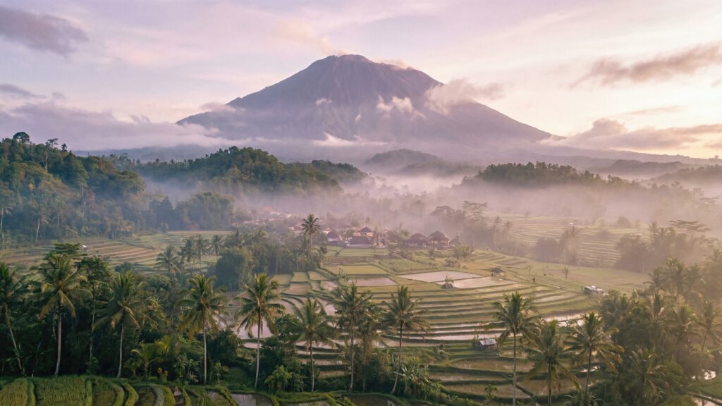
Mount Agung rises to 3,031 meters (9,944 ft) in Karangasem Regency, eastern Bali. Specifically, it is Bali’s highest peak and most sacred mountain. Additionally, it is an active stratovolcano southeast of the Mount Batur caldera.
The name “Agung” means “Paramount” or “Great” in Balinese and Indonesian. Moreover, Balinese Hindus consider the mountain a replica of the mythical Mount Meru — the central axis of the Hindu universe. Furthermore, Agung functions as the “Navel of the World” in Balinese cosmology.
Additionally, Pura Besakih — Bali’s Mother Temple complex with 80+ shrines — sits on Agung’s southwestern slopes. Moreover, Pura Pasar Agung ranks as the second-highest temple on the mountain. Importantly, the 1963-1964 eruption blew approximately 100 meters off the summit — reducing elevation from roughly 3,142m to the current 3,031m.
Furthermore, 2025 brought significant regulatory changes. Specifically, January 2025 introduced mandatory licensed guides for all foreign tourists. Additionally, tourists attempting unguided climbs have been deported. Currently, PVMBG maintains Alert Level 1 “Normal” as of April 2026 — the lowest risk classification.
Find Hotels, Flights & Trips for the World’s Best Hiking Destinations
The Global Summit Guide Travel Shop on Expedia — curated for outdoor adventurers, mountaineers, and serious hikers. Patagonia to the Alps. Nepal to the Rockies. Curated lodging for every region we cover.
Explore Travel Shop on Expedia →Two main routes exist. First, the Pura Besakih Route reaches the actual western summit (3,031m) over 6-7 hours ascending. Second, the Pura Pasar Agung Route reaches the southern crater rim (~3,031m, approximately 100m below the true summit) in 3.5-5 hours. Importantly, the connecting trail between the two summits was destroyed in the 2017 eruption. Ultimately, this guide covers everything needed for a safe, legal, and spiritually respectful 2026 Mount Agung climb.
(9,944 ft)
Karangasem Regency
as of April 2026
1,600+ deaths
Mount Agung Location & Summit Weather
Check live 7-day forecast conditions at the Mount Agung summit (3,031m). Additionally, view the interactive terrain map showing Agung’s position in eastern Bali, Karangasem Regency, with Pura Besakih on the southwestern slopes.
Mount Agung · Bali, Indonesia
8.34°S, 115.51°ESummit Weather
Elev: 3,031 m · Pre-dawn 0-10°CMount Agung stands as Bali’s supreme sacred summit. Specifically, it combines genuine physical challenge with profound spiritual significance. Additionally, the mountain anchors Balinese Hindu cosmology as the Navel of the World. Furthermore, its catastrophic 1963 eruption remains central to Balinese cultural memory.
The peak rises to 3,031 meters (9,944 ft) in Karangasem Regency, eastern Bali. Moreover, it is an active stratovolcano positioned southeast of the Mount Batur caldera. Importantly, the 1963-1964 eruption — a VEI 5 event — blew approximately 100 meters off the original summit. Consequently, the pre-eruption elevation of roughly 3,142m reduced to the current 3,031m.
Today’s climbers encounter dramatically steep volcanic terrain. First, tropical forest at lower elevations. Second, volcanic sand and loose rocks on middle slopes. Third, extremely steep scree sections reaching 45-48 degrees on the Pasar Agung route. Fourth, the 800-meter-wide summit crater itself. Finally, the breathtaking pre-dawn summit experience with views of Mount Rinjani on Lombok (east) and Lake Batur (west) on clear days.
However, 2025 introduced critical regulatory changes. Most importantly, January 2025 marked the official implementation of mandatory licensed guides for foreign tourists. Consequently, tourists attempting unguided ascents have been deported. Additionally, the measure responded to years of safety incidents on the steep terrain.
Currently, PVMBG (Indonesian Center for Volcanology and Geological Hazard Mitigation) maintains Alert Level 1 “Normal” as of April 2026. Specifically, this is the lowest of four risk classifications. Moreover, climbing remains open subject to guide availability and Hindu ceremony schedules. Notably, the annual Ida Bhatara Turun Kabeh (IBTK) ceremony typically closes the Besakih route during April-May.
Most importantly, Mount Agung is a sacred pilgrimage destination, not merely a climbing objective. Specifically, Pura Besakih — the Mother Temple of Bali with 80+ shrines — sits on the southwestern slopes. Additionally, Pura Pasar Agung serves as the second-highest temple on the southern flanks. Furthermore, climbers are expected to approach with appropriate respect: modest clothing, quiet behavior at temples, and small offerings at key points. Ultimately, Agung offers one of Asia’s most culturally meaningful volcano climbs.
As of January 2025, Bali authorities implemented mandatory licensed guide requirements for all foreign tourists climbing Mount Agung. Specifically, tourists attempting unguided ascents have been deported. Additionally, current PVMBG status is Alert Level 1 “Normal” as of April 2026 — the lowest risk classification. Consequently, climbing is currently open subject to ceremony closures and guide availability. See the 2026 Permit section for the booking walkthrough.
Despite being only 3,031 meters — lower than many tourist-oriented peaks — Mount Agung delivers extreme physical difficulty. Specifically, the Pasar Agung route reaches slopes of 45-48 degrees. Additionally, the Besakih route covers 7 kilometers with 2,000+ vertical meters over 6-7 hours ascent. Furthermore, summit-day temperatures drop to 0-10°C pre-dawn. Consequently, many climbers find Agung substantially harder than expected. See the Hazard Management section for essential preparation.
All 2026 figures were verified against PVMBG (Indonesian Center for Volcanology and Geological Hazard Mitigation) current alert status, Smithsonian Institution Global Volcanism Program records, and Wikipedia’s verified historical database. Additionally, historical eruption data draws on peer-reviewed volcanology research documenting the 1963-1964 and 2017-2019 events. Furthermore, route descriptions reference established Bali trekking operators, Pura Besakih temple authorities, and Karangasem Regency tourism documentation. Notably, the January 2025 guide mandate is confirmed through Indonesian immigration and tourism enforcement records. Fact-check: April 22, 2026.
Mount Agung at a Glance
Why Mount Agung Holds Iconic Status
Bali’s Highest and Most Sacred Peak
Mount Agung stands at 3,031 meters as Bali’s highest summit. Additionally, it is considered the most sacred mountain in Balinese Hindu cosmology. Moreover, the name “Agung” literally means “Paramount” or “Great” — reflecting its supreme spiritual status.
Replica of Mount Meru
Balinese Hindus consider Mount Agung a physical manifestation of Mount Meru — the central axis of the Hindu universe. Specifically, this makes Agung the “Navel of the World” in Balinese cosmology. Additionally, traditional houses orient toward Agung as the sacred direction (kaja).
Home of Pura Besakih Mother Temple
Pura Besakih — Bali’s Mother Temple complex — sits on Agung’s southwestern slopes with more than 80 individual shrines. Specifically, this is the most important Hindu temple complex on Bali. Moreover, the 1963 eruption’s lava flows famously diverted around Besakih — sparing the sacred site.
The Catastrophic 1963 Eruption
The 1963-1964 eruption was a VEI 5 event — one of the 20th century’s deadliest. Specifically, it killed 1,600+ people and displaced 86,000. Additionally, it occurred during the Eka Dasa Rudra ceremony — the 100-year Hindu ritual at Besakih. Tragically, lava narrowly missed the temple itself.
Active Volcanic Monitoring
Agung remains actively monitored by PVMBG (Indonesian Center for Volcanology and Geological Hazard Mitigation). Specifically, the 2017-2019 activity series included 844 volcanic earthquakes peaking September 26, 2017. Additionally, November 21, 2017 began phreatic eruptions followed by magmatic activity November 25.
Eka Dasa Rudra Ceremony Site
The Eka Dasa Rudra — performed once every 100 years at Pura Besakih — is Bali’s most significant Hindu purification ritual. Notably, the 1963 ceremony coincided with the catastrophic eruption. Additionally, cleanup and subsequent ceremonies extended through 1979. The next Eka Dasa Rudra is scheduled for the 2060s.
Summit Views to Mount Rinjani
On clear days, the Mount Agung summit offers spectacular views across the Lombok Strait to Mount Rinjani (east) and to Lake Batur caldera (west). Specifically, these views encompass two of Indonesia’s most significant volcanic landscapes in a single panorama — a rare Southeast Asian vista.
Pilgrimage Culture Integrated with Trekking
Climbing Agung is inherently a pilgrimage. Specifically, routes begin at active Hindu temples (Pura Besakih or Pura Pasar Agung). Additionally, climbers typically make offerings before ascending. Moreover, appropriate spiritual protocols — modest attire, quiet behavior, respect for taboos — are expected throughout the climb.
Who Can Realistically Climb Mount Agung?
Mount Agung is non-technical but genuinely demanding. Importantly, no climbing skills or equipment are required. However, the extreme slope angles and long single-day effort demand serious physical preparation.
Minimum Prerequisites
- Strong cardiovascular fitness — capable of 7-12 hours continuous steep hiking
- Leg strength for extremely steep scree (45-48 degrees on Pasar Agung)
- Mental stamina for pre-dawn start at 11 PM or 2 AM
- Cold tolerance to 0-10°C at summit
- Tolerance for loose volcanic rock and scree descents
- Respect for Balinese Hindu temple protocols
- Valid travel insurance
- Budget for licensed guide and transport package ($55-$250 USD)
Mount Agung Suits These Climbers
First, Bali visitors seeking authentic cultural experience beyond beaches. Specifically, Agung delivers Bali’s most profound spiritual and physical adventure — far beyond tourist temple visits.
Second, fit trekkers ready for single-day challenge. Additionally, Agung compresses major climbing effort into one intense day — ideal for time-limited Bali itineraries.
Third, sunrise photographers. Moreover, the summit sunrise with views of Rinjani (east) and Batur (west) on clear days is extraordinary.
Fourth, those preparing for harder peaks. Notably, Agung serves as solid fitness preparation for Rinjani, Kilimanjaro, or similar objectives.
Fifth, cultural travelers interested in Hindu pilgrimage. Furthermore, the Besakih route passes through sacred temple complexes with deep spiritual significance.
Mount Agung Does NOT Suit These Travelers
First, casual Bali tourists without substantial hiking experience. Specifically, the steep scree and darkness make Agung unsuitable as a “first mountain” for unprepared visitors.
Second, those with serious cardiovascular conditions. Additionally, the intense single-day effort strains the heart significantly.
Third, travelers during ceremony closures. Importantly, the Besakih route closes during Ida Bhatara Turun Kabeh (April-May) and other major ceremonies.
Fourth, those uncomfortable with active volcano risk. Moreover, Agung’s 2017-2019 activity reminds visitors of ongoing volcanic potential.
Climbing Agung is genuinely a pilgrimage, not merely a trek. Specifically, Balinese guides often share stories of Dewi Danu, ancestral spirits, and the 1963 eruption’s symbolism throughout the climb. Additionally, climbers make small offerings at key temple points. Importantly, spiritual taboos apply: traditionally, menstruating women are asked to abstain from climbing. Moreover, modest attire and respectful behavior are expected throughout. See the Pura Besakih Route for the culturally richer approach.
Mount Agung in Southeast Asian Volcanic Geography
Agung and the Sunda Arc Volcanic System
Mount Agung sits along the Sunda Arc — the active volcanic belt formed where the Indo-Australian Plate subducts beneath the Eurasian Plate. Specifically, Indonesia has at least 129 active volcanoes, making it one of Earth’s most volcanically active regions. Moreover, Agung’s immediate neighbors include Mount Batur (northwest, 1,717m) with its own caldera, and Mount Rinjani (east across the Lombok Strait, 3,726m).
Additionally, Agung’s 1963 eruption affected global climate — atmospheric sulfur dioxide caused measurable cooling in the Northern Hemisphere. Furthermore, the 2017-2019 activity series reminded the world of ongoing volcanic potential in the region. Notably, appropriate volcanic geography context helps climbers understand Agung within Indonesia’s broader volcanic landscape.
Mount Agung Volcanic & Cultural History
Prehistoric Era: Ancient Sacred Mountain
Mount Agung has dominated Bali’s eastern landscape and religious consciousness for millennia. Specifically, Balinese animism and later Hindu traditions placed Agung at the center of cosmological mapping. Additionally, the mountain’s role as Mount Meru’s physical manifestation predates Hindu contact with Bali (circa 5th-7th centuries CE).
1710-1711: Documented Eruption
Historical Balinese manuscripts documented a major eruption in 1710-1711, estimated at VEI 4-5. Specifically, this represents the earliest well-documented Agung eruption. Additionally, Balinese chronicles describe significant ash fall and community disruption.
1843: Zollinger’s Documentation
Swiss botanist Heinrich Zollinger documented an 1843 eruption of Mount Agung during his botanical expedition to the Sunda Islands. Notably, this was among the first European-documented Indonesian volcanic events. Moreover, Zollinger’s observations contributed to early 19th-century understanding of Southeast Asian volcanism.
1963-1964: The Catastrophic VEI 5 Eruption
The 1963-1964 Mount Agung eruption stands as one of the 20th century’s deadliest volcanic events. Specifically, activity began March 18, 1963 and continued intermittently through early 1964. Tragically, pyroclastic flows, lahars, and ash fall killed more than 1,600 people. Additionally, approximately 86,000 people were displaced from surrounding villages.
Remarkably, the eruption coincided with the Eka Dasa Rudra ceremony — the most important Hindu ritual held only once every 100 years at Pura Besakih. Notably, lava flows diverted around the temple complex — sparing Pura Besakih from destruction. Consequently, Balinese Hindus interpreted this as divine intervention, reinforcing Agung’s sacred status.
Furthermore, the eruption blew approximately 100 meters off Agung’s summit. Consequently, pre-eruption elevation of roughly 3,142 meters reduced to the current 3,031 meters. Moreover, global climate effects were significant: atmospheric sulfur dioxide caused measurable temporary cooling of the Northern Hemisphere through 1964.
1979: Eka Dasa Rudra Cleanup Completion
Recovery and spiritual cleanup from the 1963 eruption continued for decades. Specifically, the official Eka Dasa Rudra ceremony completion extended through 1979. Additionally, this represents the first successfully completed modern Eka Dasa Rudra — the next scheduled for the 2060s.
2017: Renewed Volcanic Activity Begins
After 54 years of dormancy, Mount Agung renewed volcanic activity in 2017. Specifically, seismic activity intensified dramatically in September 2017 — with 844 volcanic earthquakes recorded, peaking at 300-400 per day on September 26, 2017. Additionally, authorities evacuated 122,500 people from a 12-kilometer exclusion zone.
November 21, 2017: Phreatic Eruption Begins
Mount Agung began phreatic eruption activity on November 21, 2017. Specifically, an ash cloud reached 3,842 meters elevation. Moreover, this steam-driven eruption phase preceded the more dangerous magmatic activity.
November 25, 2017: Magmatic Eruption
Four days later, on November 25, 2017, Agung began magmatic eruption — indicating fresh magma at the surface. Consequently, authorities raised alert level to maximum. Additionally, Ngurah Rai International Airport (Denpasar) closed from November 26-27, 2017 due to ash.
2017-2019: Ongoing Activity
Intermittent eruptive activity continued through 2019. Specifically, periodic ash emissions, minor lava effusion, and continued seismic activity characterized the period. Consequently, climbing access was suspended for extended periods. Notably, the side path from Pasar Agung route toward the Besakih summit was destroyed during this activity — creating the current two-separate-summit route situation.
2019-2024: Gradual Normalization
Volcanic activity gradually declined through 2019 into the early 2020s. Moreover, climbing access reopened progressively. Additionally, tourism operators resumed offering guided Agung climbs through 2020-2024. However, unguided climbing persisted as a safety concern during this period.
January 2025: Mandatory Guide Requirement
Bali authorities formally implemented the mandatory licensed guide requirement for all foreign tourists climbing Mount Agung in January 2025. Specifically, multiple factors drove this policy: years of safety incidents involving unguided climbers; respect for Hindu temple protocols; support for local Balinese guide communities; better accountability during active volcanic periods. Consequently, tourists attempting unguided ascents have been deported.
April 2026: Current Status (Alert Level 1 Normal)
As of April 2026, PVMBG maintains Alert Level 1 “Normal” for Mount Agung — the lowest of four risk classifications. Specifically, this indicates no significant indicators of imminent eruption. Consequently, climbing is currently open subject to ceremony closures. However, climbers should verify current status before departure as volcanic conditions can change.
Mount Agung Climbing Routes
Mount Agung has two main climbing routes, each ending at different summits. Importantly, the connecting path between them was destroyed in the 2017 eruption. Specifically, the choice between routes affects total duration, difficulty, and whether you reach the actual summit.
| Route | Trailhead | Summit Reached | Duration | Difficulty | Start Time |
|---|---|---|---|---|---|
| Pura Besakih | Pura Pengubengan (~1,000m) | Western summit (3,031m) | ~12 hours round-trip | Harder · Longer | ~11 PM prior night |
| Pura Pasar Agung | Pura Pasar Agung (~1,500m) | Southern crater rim (~3,031m) | ~7-8 hours round-trip | Shorter · Steeper | ~2 AM |
Pura Besakih Route
The Pura Besakih Route is the traditional pilgrimage approach to Mount Agung — reaching the actual western summit at 3,031 meters. Specifically, it begins at Pura Pengubengan, the easternmost temple in the Besakih complex, at approximately 1,000 meters elevation.
Evening departure. Most operators schedule a ~11 PM start from the trailhead. Consequently, pickup from South Bali hotels typically occurs around 7-8 PM. Additionally, the drive to Besakih from Kuta or Ubud takes 2-3 hours.
Pre-climb offerings. Climbers begin at Pura Pengubengan temple. Specifically, guides typically lead small offerings (canang sari) at the temple before ascending. Additionally, this spiritual preparation is culturally important and often meaningful for climbers.
Ascent character. The Besakih Route passes through multiple terrain zones. First, forest and cultivated land near Besakih (~1,000-1,500m). Second, volcanic forest transitioning to scrub (~1,500-2,500m). Third, extensive volcanic sand and loose scree (~2,500-3,031m). Additionally, the trail covers approximately 7 kilometers one-way with 2,000+ vertical meters gain.
Summit arrival. Most climbers reach the western summit around 5:00-6:00 AM for sunrise at approximately 6:00 AM. On clear days, views encompass Mount Rinjani to the east across the Lombok Strait, Lake Batur to the west, and much of eastern Bali below. Additionally, summit temperatures hover around 0-10°C with significant wind chill.
Descent. Return follows the same route. Specifically, the descent takes approximately 4-5 hours. Consequently, total round-trip duration reaches 12 hours including summit time. Moreover, fatigue and loose scree make descent trickier than expected.
Ceremony closures. Importantly, the Besakih Route closes during major ceremonies. Specifically, Ida Bhatara Turun Kabeh (IBTK) annually closes the route April-May. Additionally, Tawur Labuh Gentuh and other observances cause temporary closures. Always verify availability before booking.
Pura Pasar Agung Route
The Pura Pasar Agung Route is the shorter, steeper alternative to the Besakih approach. Specifically, it begins at Pura Pasar Agung temple — the second-highest temple on Agung — at approximately 1,500 meters elevation on the southern slopes.
Important summit distinction. The Pasar Agung Route reaches the southern crater rim at approximately 3,031 meters — technically the same elevation as the western summit but not the actual highest point. Specifically, the true summit sits on the western rim, about 100 meters higher than Pasar Agung’s rim at certain measurement points. Importantly, the side path connecting the two summits was destroyed during the 2017 eruption. Consequently, climbers choosing Pasar Agung cannot easily continue to the Besakih summit.
Start time and pickup. Pasar Agung climbs typically start around 2 AM. Consequently, pickup from South Bali hotels occurs around 9-10 PM the evening before. Additionally, the drive to the Pasar Agung trailhead via Selat village takes 2-3 hours.
Ascent character. The Pasar Agung Route is significantly steeper than Besakih. Specifically, slopes reach 45-48 degrees in the upper sections. Additionally, the trail covers approximately 1,500 vertical meters over 3.5-5 hours ascent. Consequently, climbers gain elevation very rapidly — which is both physically demanding and beneficial for overall shorter duration.
Terrain. The route passes through initial forest and temple grounds, then volcanic sand and loose scree, then extremely steep upper scree sections. Moreover, loose volcanic rock creates dangerous conditions — especially descending. Consequently, trekking poles are essential.
Summit arrival. Most climbers reach the southern rim around 5:00-6:00 AM for sunrise. Specifically, views from the rim are still excellent — encompassing Rinjani, Batur, and eastern Bali. However, the actual western summit cannot be easily reached from here due to the 2017 trail destruction.
Descent. Return follows the same steep trail. Additionally, descending 45-48 degree scree demands concentration. Moreover, total round-trip duration runs 7-8 hours — substantially shorter than Besakih.
2026 Mount Agung Access: Permits, Guides & Logistics
As of January 2025, Bali authorities implemented a mandatory licensed guide requirement for all foreign tourists climbing Mount Agung. Specifically, tourists attempting unguided ascents have been deported. Additionally, unlike Mount Rinjani, Agung has no official national park permit fee — costs are primarily guide services and transport. Currently, PVMBG maintains Alert Level 1 “Normal” as of April 2026.
2026 Guide Requirements
The January 2025 mandatory guide regulation requires:
- All foreign tourists must hire a licensed Balinese mountain guide
- Guides must hold valid certification from local tourism authorities
- Certification registration typically requires temple authority endorsement
- Enforcement: Tourists attempting unguided ascents have been deported
- Indonesian nationals may climb without guides but are encouraged to use local guides for safety
Cost Structure (No National Park Fee)
Unlike Mount Rinjani or many other Indonesian parks, Mount Agung has no national park permit system. Specifically, costs consist of:
- Licensed guide fee — included in tour packages
- Transport from Bali hotels — included in most packages
- Temple entry donations — typically IDR 20,000-50,000 (small amounts)
- Pre-climb refreshments and summit breakfast — included in packages
- Rental gear if needed — headlamp, walking stick (usually included)
Typical 2026 Package Pricing
Sharing Group Packages (Most Economical)
- Besakih Route sharing: $55-$75 USD per person
- Pasar Agung sharing: $65-$85 USD per person
Private Group Packages
- Private Pasar Agung: $85-$130 USD per person (small groups)
- Private Besakih: $100-$150 USD per person
- Premium Besakih with extras: $140-$180 USD per person
Overnight Camping Variants
- 1-night Besakih with campsite sunrise: $169-$250 USD per person
Add-On Costs
- Uluwatu/Nusa Dua pickup: +$20 USD (additional drive time)
- Extra early pickup (some Ubud/Kuta variants): +$10-$15 USD
What’s Included in Standard Packages
- Licensed Balinese mountain guide (English-speaking)
- Round-trip transport from South Bali hotels (Kuta, Seminyak, Sanur, Canggu, Ubud)
- Pre-climb snacks and drinks
- Summit breakfast (simple hot meal or packed meal)
- Headlamp and walking pole rental (often included)
- Temple entry donations
- Basic first aid and emergency protocols
How to Book in 2026
Step 1: Verify Current PVMBG Alert Status
First, check current PVMBG volcanic alert level at magma.vsi.esdm.go.id. Specifically, Level 1 “Normal” allows climbing, while Levels 2 (Waspada), 3 (Siaga), or 4 (Awas) prohibit it. Moreover, current status April 2026 is Level 1 Normal.
Step 2: Check Ceremony Schedule
Second, verify Hindu ceremony schedules that close the Besakih route. Specifically, Ida Bhatara Turun Kabeh runs April-May typically. Additionally, other ceremonies throughout the year cause temporary closures. Ask operators about availability for your target dates.
Step 3: Choose Route and Package
Third, decide between Besakih (true summit, longer, more cultural) and Pasar Agung (shorter, steeper, southern rim). Additionally, select sharing or private group based on budget and preference.
Step 4: Book with Licensed Operator
Fourth, book with an established Balinese trekking operator. Specifically, major operators include Bali Sunrise Trekking, Bali Jungle Trekking, and local Karangasem-based guides. Additionally, confirm licensed guide certification and recent reviews.
Step 5: Pre-Climb Confirmation
Finally, confirm pickup time and location 24-48 hours before climb. Specifically, pickup times range from 7-10 PM the evening before depending on route and your hotel location. Moreover, bring all required gear (see Gear Checklist section).
Important 2026 Rules and Considerations
- Alert Level Check: Always verify PVMBG status before departure
- Ceremony closures: Besakih closes during IBTK (April-May) and other rituals
- Guide mandate: Unguided climbing can result in deportation
- Temple respect: Modest attire, quiet behavior, appropriate offerings
- Menstruation taboo: Traditional Balinese belief — women are asked to abstain during menstruation
- Photography: Respect “no photography” signs at sacred areas
- Summit timing: Plan for pre-dawn start; summit sunrise around 6 AM
- No technical gear: Standard hiking equipment sufficient
Getting to Mount Agung
- Ngurah Rai International Airport (DPS): Bali’s main airport in Denpasar
- From Kuta/Seminyak: 2.5-3 hours drive to Besakih or Pasar Agung
- From Ubud: 1.5-2 hours drive
- From Sanur: ~2 hours drive
- From Uluwatu/Nusa Dua: 3+ hours drive (typically +$20 USD package fee)
- Pura Besakih trailhead: Via Klungkung and Rendang
- Pura Pasar Agung trailhead: Via Selat village
Mount Agung Climbing Costs in 2026
Mount Agung costs remain among the most affordable serious volcano climbs in Southeast Asia. Specifically, budget sharing-group packages start around $55 USD, while premium overnight variants can reach $250 USD.
No National Park Fee
Unlike Mount Rinjani (Rp250,000/day Class 1 fees) or Mount Kinabalu (RM400+ permit), Mount Agung has no official national park permit. Specifically, all costs go to guide services, transport, and small temple donations. Moreover, this makes Agung unusually accessible financially.
Typical Package Prices (All-Inclusive USD)
Sharing Group Packages (Most Economical)
- Besakih Route sharing: $55-$75 USD per person
- Pasar Agung Route sharing: $65-$85 USD per person
Private Group Packages
- Private Pasar Agung: $85-$130 USD per person
- Private Besakih: $100-$150 USD per person
- Premium Besakih (small group, extras): $140-$180 USD per person
Overnight Camping Variant
- 1-night Besakih camping: $169-$250 USD per person (includes tent at campsite, sunrise from elevated viewpoint)
Pickup Location Add-Ons
- Uluwatu/Nusa Dua pickup: +$20 USD (extra driving time)
- Very early Ubud pickup: +$10 USD typical
What’s Included in Standard Packages
- Licensed Balinese mountain guide (required by law since January 2025)
- Round-trip transport from South Bali hotels
- Pre-climb refreshments (tea, coffee, snacks)
- Summit breakfast (hot porridge, sandwiches, or similar)
- Headlamp and walking stick rental (usually included)
- Temple entry donations (small)
- Bottled water during climb
- Basic first aid supplies
Additional Costs to Budget
- Guide tips (customary): IDR 100,000-300,000 per guide (~$6-$19 USD)
- Travel insurance: $10-$30 USD for short-term coverage
- Personal snacks and extra water: $5-$15 USD
- Rental gear if needed: Warm jacket rental $5-$10 USD typical
- Pre/post-climb hotels: $30-$150 USD per night depending on area
- Temple donations (beyond included): IDR 20,000-50,000 per person
Total Cost Scenarios (USD)
Budget sharing group Besakih. Package cost, guide tip, and small extras total approximately $75-$105 USD
Standard private Pasar Agung. Private package with tips, insurance, and extras totals approximately $115-$170 USD
Premium private Besakih. Premium package with full tips and insurance totals approximately $175-$230 USD
Overnight camping Besakih. Camping package with full extras totals approximately $200-$290 USD
Mount Agung Gear Checklist
Mount Agung gear requirements are simpler than multi-day treks but must address specific challenges. Specifically, the combination of tropical valley heat and near-freezing summit cold demands proper layering.
Footwear (Critical)
- Broken-in hiking boots with strong ankle support
- Grippy soles essential for volcanic scree
- 2 pairs quick-dry hiking socks
- Gaiters (helpful for keeping scree out)
- Waterproof optional but recommended
- No sandals or casual shoes — real boots only
Clothing System
- Quick-dry base layer (ascent through forest)
- Long-sleeve thermal layer (higher elevations)
- Fleece or mid-weight jacket
- Down or insulated jacket (essential summit)
- Waterproof shell jacket
- Trekking pants
- Warm hat (beanie)
- Gloves (thin pair minimum)
- Buff or neck gaiter
Lighting (Critical for Pre-Dawn)
- Headlamp 200+ lumens (11 PM or 2 AM start requires reliable light)
- Spare batteries essential
- Backup small flashlight
- Most operators provide headlamp — bring personal backup
Hydration & Food
- Water 2-3L capacity
- Personal energy snacks: nuts, chocolate, bars
- Electrolyte tablets helpful
- Small cash in IDR for extras
Sun Protection (Descent)
- Sunglasses (UV400 for scree glare)
- Sunscreen SPF 50+ (equatorial descent)
- Sun hat for descent
- Lip balm with SPF
Temple Protocol
- Sarong or long pants (required at temples)
- Sash (often provided at temple entry)
- Modest shirt for temple photography
- Small offerings (optional — bring a few incense sticks or flowers)
Health & First Aid
- Personal first aid kit
- Blister treatment (Compeed or moleskin)
- Ibuprofen and paracetamol
- Anti-diarrhea medication
- Personal prescriptions
- Hand sanitizer
- Tissues/wet wipes
Pack & Misc
- Daypack 20-30L with rain cover
- Trekking poles (ESSENTIAL for scree descent)
- Camera with extra battery
- Phone with offline map backup
- Small towel
- Passport (carry for verification if needed)
Mount Agung Hazard Management
Mount Agung is non-technical but presents serious hazards. Specifically, the combination of extreme slope angles, pre-dawn darkness, and active volcanism creates genuine risk.
Extreme Slope Steepness
The Pasar Agung route features 45-48 degree slopes in upper sections — exceptional steepness for a non-technical route. Specifically, loose volcanic scree on these grades creates genuine falling hazards. Additionally, descending these sections fatigued requires intense concentration. Consequently, trekking poles are essential, not optional.
Pre-Dawn Start Conditions
Both routes require pre-dawn starts (11 PM or 2 AM). Specifically, this means climbing in complete darkness with only headlamp illumination. Additionally, route-finding without visual landmarks depends entirely on the licensed guide. Moreover, unexpected weather or headlamp failure creates serious risk in darkness.
Cold Summit Temperatures
Summit temperatures drop to 0-10°C pre-sunrise year-round. Moreover, wind chill at the exposed summit ridge makes conditions feel significantly colder. Consequently, many climbers underestimate cold on a tropical Bali mountain. Essential gear includes down jacket, warm hat, and gloves.
Volcanic Activity Risk
Mount Agung remains an active volcano. Specifically, the 2017-2019 activity demonstrated how rapidly conditions can change. Additionally, PVMBG monitors Agung continuously and raises alert levels when indicators change. Consequently, current status must be verified before any climb. Importantly, Alert Level 2 or higher prohibits climbing.
Loose Volcanic Rock
Upper sections of both routes feature extensive loose volcanic rock and ash. Specifically, rocks can shift underfoot unexpectedly. Moreover, the descent is particularly dangerous when fatigue sets in. Consequently, careful step placement and sturdy footwear are critical.
Weather Changes
Mountain weather can shift rapidly. Specifically, tropical storms can develop during shoulder seasons. Additionally, thick cloud cover at the summit is common — obscuring the famous sunrise view. Moreover, wet volcanic scree becomes extremely slippery. Consequently, pack waterproof gear regardless of forecasts.
Altitude Effects
While 3,031m is lower than many altitude-concerning peaks, the rapid ascent rate (2,000m gain in 6-7 hours on Besakih, or 1,500m in 3.5-5 hours on Pasar Agung) can cause mild altitude symptoms. Specifically, headache, nausea, and fatigue are common. However, genuine altitude sickness is rare at this elevation.
Hazard Management Principles
- Always hire a licensed Balinese mountain guide (mandatory since January 2025)
- Verify PVMBG alert level before departure
- Check ceremony schedules before booking
- Use trekking poles on both ascent and descent
- Bring backup headlamp and batteries
- Pack warm summit layers regardless of valley weather
- Stay with your group — never attempt unguided
- Respect Hindu temple protocols
- Avoid climbing during Hindu ceremonies
- Purchase travel insurance with emergency coverage
Mount Agung Safety & Success Rates
Mount Agung success rates run approximately 85-95% for climbers who reach the trailhead with proper preparation. Specifically, weather is the most common cause of summit failure rather than physical inability.
Typical Failure Modes
Failed Agung summits typically result from several factors. First, weather closures obscuring summit views. Second, unexpected ceremony closures on booking day. Third, physical exhaustion on the steep Pasar Agung route. Fourth, altitude symptoms in the rapid ascent. Fifth, equipment failure (headlamp, boots).
Emergency Response
Local guides maintain emergency protocols for Mount Agung. Specifically, radio communication with base villages provides coordination. Additionally, evacuation to Selat (Pasar Agung) or Rendang/Klungkung (Besakih) occurs via vehicle when climbers descend. However, helicopter evacuation is not standard for Agung — unlike some larger peaks.
2025-2026 Safety Improvements
The January 2025 mandatory guide requirement substantially improved Mount Agung safety statistics. Specifically, fewer unguided accidents and better volcanic activity awareness followed implementation. Additionally, licensed guide training requirements ensure baseline emergency response capability. Moreover, PVMBG’s continuous monitoring provides early warning of volcanic activity.
Comparison to Similar Peaks
Mount Agung is substantially easier than Mount Rinjani due to shorter single-day duration (versus Rinjani’s 3-day minimum). However, Agung has steeper upper sections than Rinjani’s summit push. Additionally, Agung is comparable to Mount Kinabalu in total effort but with more spiritual/cultural depth. Notably, Agung’s pre-dawn start and potential volcanic closures create unique complications unlike other Southeast Asian peaks.
When to Climb Mount Agung
Dry Season: April-October (Recommended)
Bali’s dry season runs April through October. Specifically, this provides the stable weather needed for safe Agung climbing. Importantly, this coincides with Hindu ceremony calendars that affect route availability.
Best Periods Within the Season
April (Transition)
- Weather improving from wet season
- Some late rain possible
- Besakih Route often closes for Ida Bhatara Turun Kabeh (IBTK) ceremony
- Pasar Agung Route typically available
May (Good)
- Dry season establishing
- Clear summit visibility
- IBTK ceremony may continue early May (Besakih closed)
- Pasar Agung fully available
June-July (Excellent)
- Peak dry season — most stable weather
- Clear summit views likely
- Cool nights at elevation
- Moderate tourist crowds
August-September (Peak)
- Driest conditions, best visibility
- Highest tourist demand — book ahead
- Cool summit nights
- Both routes generally available
October (Shoulder Season)
- Dry conditions continuing
- Fewer crowds
- Occasional early rain possible late October
- Good alternative to peak August
November-March (Wet Season, Not Recommended)
- Tropical monsoon with heavy rainfall
- Dangerously slippery volcanic scree
- Summit views often obscured by clouds
- Thunderstorms possible
- Most operators reduce or suspend tours
- Some climbers attempt on rare clear days
Hindu Ceremony Closures
Several major Hindu ceremonies affect Mount Agung climbing access. Specifically, Ida Bhatara Turun Kabeh (IBTK) typically runs April-May at Pura Besakih — closing the Besakih Route during the ceremony. Additionally, Tawur Labuh Gentuh and other observances cause temporary closures. Moreover, the rare Eka Dasa Rudra ceremony (held every 100 years at Besakih; last 1963 with cleanup through 1979) is not scheduled again until the 2060s.
Booking Timing
Book 2-4 weeks ahead for peak season (August-September). Additionally, shoulder season (May-June, October) can be booked 1-2 weeks out. Moreover, unlike multi-day treks with quotas, Agung guide availability is generally flexible. Consequently, same-week or next-day bookings often work during shoulder periods.
Temperature Reference
- Trailhead villages (Besakih ~1,000m, Pasar Agung ~1,500m): 18-25°C day, 15-20°C night
- Middle elevations (~2,000-2,500m): 12-18°C ascent
- Summit (~3,031m) pre-dawn: 0-10°C (feels colder with wind chill)
- Summit post-sunrise: Warms to 10-15°C quickly
- Descent valley: 20-30°C daytime
Mount Agung’s Volcanic History
1710-1711 — Earliest Documented Eruption
VEI 4-5 estimatedBalinese manuscripts documented a major eruption of Mount Agung in 1710-1711. Specifically, this represents the earliest well-documented eruption from historical sources. Additionally, the event caused significant community disruption. Moreover, this predates European scientific documentation by over a century.
1843 — Zollinger’s Scientific Documentation
First European documentationSwiss botanist Heinrich Zollinger documented an 1843 Mount Agung eruption during his Sunda Islands expedition. Specifically, this became one of the earliest European scientific records of Indonesian volcanism. Additionally, Zollinger’s observations contributed to early 19th-century understanding of Southeast Asian volcanoes.
1963-1964 — The Catastrophic Eruption
1,600+ deaths, 86,000 displacedThe 1963-1964 Mount Agung eruption was a catastrophic VEI 5 event killing 1,600+ people and displacing 86,000. Notably, it occurred during the Eka Dasa Rudra ceremony — the 100-year Hindu ritual at Besakih. Remarkably, lava flows diverted around Pura Besakih, sparing the temple. Additionally, the eruption reduced Agung’s elevation by ~100m (from 3,142m to 3,031m). Moreover, global temperature cooling followed.
November 21, 2017 — Phreatic Eruption Begins
Ash cloud 3,842mAfter 54 years of dormancy, Mount Agung began phreatic (steam-driven) eruption activity on November 21, 2017. Specifically, ash clouds reached 3,842 meters elevation. Previously, 844 volcanic earthquakes had occurred September-November 2017, peaking at 300-400 per day on September 26. Additionally, 122,500 people were evacuated from the 12km exclusion zone.
November 25-27, 2017 — Magmatic Eruption
Airport closure, ongoing activityMount Agung escalated to magmatic eruption on November 25, 2017 — indicating fresh magma at the surface. Consequently, Ngurah Rai International Airport closed November 26-27, 2017 due to ash. Additionally, intermittent activity continued through 2019. Notably, the side path from Pasar Agung route to Besakih summit was destroyed during this activity period.
Lessons from Mount Agung’s History
- Indigenous Balinese traditions recognized Agung’s sacred and volcanic dual nature for centuries before scientific volcanology
- The 1963 eruption during Eka Dasa Rudra reinforced the mountain’s mystical status in Balinese culture
- Lava diverting around Pura Besakih in 1963 created enduring religious narrative
- Agung’s 100-meter elevation loss in 1963 demonstrates volcanic landscape impermanence
- The 54-year dormancy before 2017 shows how active volcanoes rest and wake
- 2017-2019 activity reminded modern tourism of ongoing volcanic risks
- January 2025 mandatory guide regulation reflects lessons from years of safety incidents
- The destroyed Pasar-to-Besakih connecting path illustrates how eruptions permanently alter landscapes
Plan Your Mount Agung Climb
Reaches actual 3,031m western summit. Starts ~1,000m, 7km ascent, 6-7 hours up, 12 hours round-trip. Culturally rich pilgrimage approach.
View route details →Southern crater rim (~3,031m, not true summit). Starts ~1,500m. 45-48° slopes. 3.5-5 hours up, 7-8 hours round-trip.
View Pasar Agung →Mandatory licensed guide since January 2025. No national park fee. Tourists attempting unguided climbs have been deported.
View permit details →Budget sharing $55-$85 USD, private $85-$180 USD, premium $140-$250 USD. No permit fees — primarily guide and transport costs.
See cost details →45-48 degree slopes. Pre-dawn cold 0-10°C. Volcanic activity monitoring. Loose scree. Pre-dawn navigation.
View safety guide →Dry season April-October. Avoid November-March monsoon. Ceremony closures: IBTK April-May.
View season details →Frequently Asked Questions About Climbing Mount Agung
How much does it cost to climb Mount Agung in 2026?
Climbing Mount Agung in 2026 ranges from approximately $55-$250 USD. Budget sharing-group Besakih route tours start around $55-$75 USD per person. Private Pasar Agung tours cost $85-$130 USD. Premium Besakih summit packages reach $140-$180 USD. One-night camping variants run $169-$250 USD. Add approximately $20 USD for Uluwatu or South Bali hotel pickup. Package prices include mandatory licensed guide (required since January 2025), transport to trailhead, pre-dawn snacks and breakfast at summit, headlamp rental, and temple entry donations. Unlike Mount Rinjani, Agung has no official national park permit fee — costs are primarily guide services and transport. Additional costs include guide tips IDR 100,000-300,000 per guide, travel insurance, and small temple donations.
How difficult is climbing Mount Agung?
Mount Agung is a demanding single-day climb despite being only 3,031 meters. Specifically, the primary challenge is extremely steep terrain — slopes reach 45-48 degrees on the Pasar Agung route. Additionally, the Pura Besakih route requires 6-7 hours ascending approximately 2,000 vertical meters through 7 kilometers of trail to the actual western summit. Meanwhile, the Pura Pasar Agung route is shorter but steeper: 3.5-5 hours ascending 1,500 vertical meters to the southern crater rim (~3,031m, approximately 100m below the true summit). Both routes require pre-dawn departures: Besakih starts around 11 PM the night before, Pasar Agung around 2 AM. Climbers face cold summit temperatures of 0-10°C pre-sunrise, loose volcanic scree, and long total trek durations of 7-12 hours. No technical climbing skills needed, but excellent fitness and mental stamina are essential.
What is the 1963 Mount Agung eruption?
The 1963-1964 Mount Agung eruption was a catastrophic VEI 5 event — one of the deadliest volcanic eruptions of the 20th century. Activity began March 18, 1963 and continued intermittently through early 1964. Tragically, more than 1,600 people died from pyroclastic flows, lahars, and ash fall. Approximately 86,000 people were displaced. The eruption occurred during the Eka Dasa Rudra ceremony — the most important Hindu ritual held every 100 years at Pura Besakih temple on Agung’s slopes. Remarkably, lava flows diverted around Besakih temple, sparing the sacred complex — interpreted by Balinese as divine intervention. The eruption blew approximately 100 meters off Agung’s summit, reducing elevation from roughly 3,142m to the current 3,031m. Atmospheric sulfur dioxide caused measurable temporary cooling of the Northern Hemisphere.
When is the best time to climb Mount Agung?
The best time to climb Mount Agung is during Bali’s dry season from April through October. Peak conditions occur May through September with stable weather, clear summit visibility, and minimal rainfall. July-August offers the driest conditions but also the highest tourist crowds. June and September provide excellent shoulder-season climbing with fewer crowds. Avoid November through March due to monsoon rains that make trails dangerously slippery and summit views obscured by clouds. Hindu ceremony closures affect specific dates throughout the year. Ida Bhatara Turun Kabeh (IBTK) typically runs April-May at Pura Besakih — closing the Besakih route during the ceremony. Tawur Labuh Gentuh and other religious observances also temporarily close routes. Eka Dasa Rudra (100-year major ceremony, last held 1963 with cleanup in 1979) is not scheduled again until the 2060s. Summit temperatures run 0-10°C pre-dawn year-round.
Do I need a guide to climb Mount Agung?
Yes, as of January 2025, Bali authorities implemented a mandatory licensed guide requirement for all foreign tourists climbing Mount Agung. Tourists attempting unguided ascents have been deported. This regulation responds to years of safety incidents involving unguided climbers on the steep volcanic terrain. Guides are primarily from Balinese Hindu communities near Pura Besakih and Pura Pasar Agung temples — hiring them supports local temple maintenance and indigenous livelihoods. Guide responsibilities include route-finding through volcanic scree in darkness, safety management on the 45-48 degree slopes, appropriate temple protocol and offerings, cultural interpretation of sacred sites, and emergency response. Most guides are multi-generational locals with deep knowledge of the mountain’s spiritual dimensions. Standard tour packages include guide, transport from South Bali hotels, pre-dawn refreshments, and summit breakfast.
What is Pura Besakih?
Pura Besakih is the “Mother Temple of Bali” — the most important and largest Hindu temple complex on the island. Located on the southwestern slopes of Mount Agung at approximately 1,000 meters elevation, Besakih contains more than 80 individual shrines organized around the central Pura Penataran Agung. The complex has existed for centuries, with some structures dating to pre-Hindu times.
During the catastrophic 1963 Mount Agung eruption, lava flows diverted around Pura Besakih, sparing the complex — interpreted by Balinese Hindus as divine intervention. Additionally, the most important ceremony held at Besakih is the Eka Dasa Rudra — a once-per-century purification ritual. Notably, the 1963 eruption occurred during the first modern Eka Dasa Rudra, with cleanup extending to 1979. Moreover, the annual Ida Bhatara Turun Kabeh (IBTK) ceremony runs April-May, bringing thousands of pilgrims and temporarily closing the Besakih climbing route. Importantly, the Pura Besakih climbing route begins at Pura Pengubengan, the easternmost temple in the complex.
Why is Mount Agung sacred to Balinese Hindus?
Mount Agung holds supreme spiritual significance for Balinese Hindus — considered the “Navel of the World” and a replica of the mythical Mount Meru, the central axis of the Hindu universe. Specifically, the name “Agung” literally means “Paramount” or “Great” in Indonesian/Balinese. Additionally, the mountain’s spiritual importance pervades all aspects of Balinese culture: traditional Balinese houses, temples, and villages are oriented with Agung (kaja direction) considered the sacred direction.
Moreover, the “Mother Temple” of Bali, Pura Besakih, sits on the mountain’s southwestern slopes with 80+ shrines. Pura Pasar Agung — the “second-highest temple” — sits higher on the southern flanks. Climbers typically make offerings before ascending. Notably, the 1963 eruption occurred during the Eka Dasa Rudra ceremony, with lava sparing Pura Besakih — reinforcing Agung’s sacred status. Appropriate spiritual behavior during climbs includes respectful attire, small offerings at key points, and avoiding the summit during active ceremonies or menstruation (traditional taboo).
What are the two main Agung routes?
Mount Agung has two main climbing routes, each ending at different summits. First, the Pura Besakih Route is longer and reaches the actual western summit (3,031m). Specifically, it starts at Pura Pengubengan temple (easternmost of the Besakih complex) and covers approximately 7 kilometers over 6-7 hours of ascent. Total round-trip takes approximately 12 hours including summit time. Additionally, departures typically begin at 11 PM for pre-dawn summit arrival.
Second, the Pura Pasar Agung Route is shorter but steeper. It starts at Pura Pasar Agung temple (the second-highest temple at ~1,500m elevation) on the southern slopes. Ascent takes 3.5-5 hours covering approximately 1,500 vertical meters. Moreover, this route reaches the southern crater rim at approximately 3,031m elevation — approximately 100m below the actual summit. Slopes reach 45-48 degrees on the Pasar Agung route. Departures typically begin at 2 AM. Importantly, the side path connecting the Pasar Agung southern rim to the actual Besakih summit was destroyed during the 2017 eruption.
Is Mount Agung safe to climb?
Mount Agung is currently safe for experienced trekkers with licensed guides as of April 2026. PVMBG (Indonesian Center for Volcanology and Geological Hazard Mitigation) maintains Alert Level 1 “Normal” for Agung — the lowest risk classification. However, Agung remains an active volcano with significant eruption history: 1710-1711 (VEI 4-5), 1843, 1963-1964 (catastrophic VEI 5, 1,600+ deaths), and 2017-2019 (Phreatic eruptions starting November 21, 2017 with magmatic activity November 25, 2017; 844 volcanic earthquakes peaking 300-400 per day on September 26, 2017; 122,500 evacuated from 12km exclusion zone; Ngurah Rai International Airport closed November 26-27, 2017). Climbers should verify current PVMBG alert status before departure. At Alert Level 2 (Waspada) or higher, climbing is prohibited. Beyond volcanic hazards, climbers face steep 45-48 degree scree slopes, pre-dawn cold, loose volcanic rock, and navigation challenges in darkness.
How do I get to Mount Agung from Bali?
Mount Agung sits in Karangasem Regency in eastern Bali, approximately 2-3 hours drive from South Bali tourist areas. Coming from Denpasar (Ngurah Rai Airport) or Kuta-Seminyak-Canggu areas: expect 2.5-3 hours by car to Pura Besakih. Additionally, travelers from Ubud should expect 1.5-2 hours to Besakih. Meanwhile, Sanur pickups take approximately 2 hours. The Pura Besakih trailhead (Pura Pengubengan, within the Besakih temple complex) is at approximately 1,000m elevation. Additionally, the Pura Pasar Agung trailhead (on the southern slopes) is accessed via Selat village — approximately similar drive times. Most climbing tours include transport from South Bali hotels as part of the package. Typical departure times: for Besakih route, pickup at 7-8 PM the evening before (11 PM trailhead start); for Pasar Agung route, pickup at 9-10 PM the evening before (2 AM trailhead start). Uluwatu and Nusa Dua pickups typically add 30-60 minutes and $20 USD to package costs.
Related Volcanoes, Sacred Mountains & Planning Guides
Mount Agung pairs excellently with other Indonesian and Southeast Asian peaks. Additionally, many climbers pair Agung with Rinjani on Lombok or other regional volcano objectives.
Plan Your 2026 Mount Agung Climb
Mount Agung offers Bali’s most profound mountain experience — combining genuine physical challenge with deep Hindu spiritual significance. Importantly, 2026 requires booking through licensed operators due to the January 2025 mandatory guide regulation. Verify current PVMBG alert status and ceremony schedules before booking.
Was this helpful?
🏔Related peaks nearby
🧭Explore & compare
Global Summit Guide is an independent mountaineering resource founded in 2026. The team combines first-hand trekking and climbing experience with in-depth research and professional health and nutrition review to help climbers choose objectives, prepare properly, and stay safe.
Health, altitude, and nutrition content is reviewed by Taylor Ludlow (Registered Nurse) and Brigg Hoopes (Nutritionist).
What We Don't Know Yet
Mountain information changes quickly. This box explains the limits of what this page can responsibly promise.
- Permit availability, reservation windows, quotas, and official fee rules may change after this page is updated.
- Weather, snowpack, avalanche risk, road access, and route conditions can change quickly and may be different on your climbing dates.
- Route conditions, trailhead access, crevasse exposure, stream crossings, and rescue access may vary from published planning guidance.
- Total trip cost can change with flights, lodging, guide pricing, permits, gear rentals, transportation, and exchange rates.
- Gear requirements can change by season, route variation, weather window, personal cold tolerance, and guide-service requirements.
Verify current conditions with official land managers, guide services, local forecasts, and current route reports before booking or climbing.
Part of this Global Summit Guide cluster
Explore the complete Mountains guide for more context, routes, planning links, and related resources.
Mountaineering, rock and ice climbing, glacier travel, and high-altitude activity are inherently dangerous and can result in serious injury or death. The information on Global Summit Guide is provided for general informational and educational purposes only and is not a substitute for professional instruction, qualified guiding, proper equipment, or your own judgment and experience.
Route conditions, weather, snowpack, permits, regulations, and hazards change constantly and may differ from what is described here. Details may be incomplete, out of date, or contain errors. Always verify current information with local authorities, certified guides, and official sources before making any decision in the mountains.
Nothing on this site is medical, legal, or financial advice. Our fitness, acclimatization, altitude, and nutrition content is general in nature; consult a qualified physician before beginning any strenuous exercise program or exposing yourself to high altitude.
You are solely responsible for your own safety and decisions. To the fullest extent permitted by law, Global Summit Guide and its team accept no liability for any loss, injury, damage, or expense arising from use of, or reliance on, this information. By using this site you acknowledge these risks and accept these terms.
Some links on this site may be affiliate links. If you buy through them we may earn a small commission at no extra cost to you; this never affects our recommendations.
Global Summit Guide recommendation path
Next Best Mountain to Research
Use these recommendations to continue the right planning path instead of stopping on one page.
Use current permit, weather, route, and operator information before booking or climbing.