
Last updated May 23, 2026
Climbing Mount Rinjani: The Complete 2026 Trail, Permit & Samalas Volcano Guide
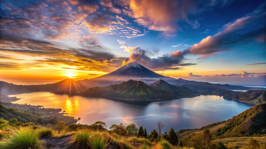
Mount Rinjani rises to 3,726 meters (12,224 ft) on Lombok Island, Indonesia. Specifically, it is Indonesia’s second-highest volcano after Kerinci on Sumatra. Moreover, Rinjani anchors the Mount Rinjani Volcanic Complex — a UNESCO Global Geopark since April 2018.
The mountain sits at the heart of the vast Segara Anak caldera — a 6×8.5 km volcanic basin created by the catastrophic 1257 Samalas eruption. Specifically, this VEI 7 event was one of the largest volcanic eruptions in the past 7,000 years. Additionally, it caused a global volcanic winter and destroyed the Lombok kingdom of Pamatan.
Furthermore, 2026 introduces major permit changes. First, Ministerial Regulation No. 17/2025 (effective November 3, 2025) upgraded Rinjani to Class 1 classification. Second, main routes Sembalun, Senaru, and Torean now cost Rp250,000 per day for foreign visitors. Third, the mandatory e-Rinjani digital permit system enforces daily quotas — 400 combined permits for main routes (240 international + 160 domestic).
Additionally, 2026 regulations require licensed guides (1 guide per 4 trekkers minimum), 2 porters per group, and valid insurance documentation. Notably, premium helicopter evacuation insurance became available from March 2026.
Find Hotels, Flights & Trips for the World’s Best Hiking Destinations
The Global Summit Guide Travel Shop on Expedia — curated for outdoor adventurers, mountaineers, and serious hikers. Patagonia to the Alps. Nepal to the Rockies. Curated lodging for every region we cover.
Explore Travel Shop on Expedia →Importantly, Rinjani is sacred to both the indigenous Sasak people and Balinese Hindus. Specifically, the guardian spirit Dewi Anjani protects those who climb with humility. Moreover, the annual Pekelem Ceremony brings Hindu pilgrims to Segara Anak Lake. The 2026 trekking season runs April 1 to December 31. Ultimately, this guide covers everything needed for a safe, legal, and meaningful 2026 Rinjani trek.
(12,224 ft)
(~$16 USD foreigners)
240 intl + 160 domestic
VEI 7 caldera-forming
Mount Rinjani Location & Sembalun Crater Rim Weather
Check live 7-day forecast conditions at Sembalun Crater Rim (2,639m), the base camp before the pre-dawn summit push. Additionally, view the interactive terrain map showing Rinjani’s position in the Segara Anak caldera, Lombok Island.
Mount Rinjani · Lombok, Indonesia
8.41°S, 116.46°ECrater Rim Weather
Elev: 2,639 m · Sembalun campMount Rinjani occupies a unique place in Indonesian trekking. Specifically, it combines genuine physical challenge with exceptional geological and cultural significance. Additionally, the mountain sits within the 1257 Samalas caldera — one of the largest volcanic craters on Earth. Furthermore, Lonely Planet consistently ranks Rinjani among the world’s greatest treks.
The peak rises to 3,726 meters (12,224 ft) as Indonesia’s second-highest volcano. Moreover, Rinjani stands within the vast Segara Anak caldera — a 6×8.5 kilometer basin formed when Mount Samalas collapsed in 1257 CE. Specifically, that VEI 7 eruption ranks among the largest in human history.
Today’s climbers encounter dramatically varied terrain. First, tropical rainforests at lower elevations. Second, open savanna grasslands on the eastern approach. Third, volcanic ridges climbing toward the crater rim. Fourth, the deep-blue Segara Anak Lake lying 2,000m in elevation within the caldera. Finally, the steep volcanic scree of the summit push itself.
However, 2026 introduces significant regulatory changes. Most importantly, Ministerial Regulation No. 17/2025 (effective November 3, 2025) reclassified Rinjani as a Class 1 national park. Consequently, Sembalun, Senaru, and Torean route permits now cost Rp250,000 per day (~$16 USD) for foreigners. Furthermore, the mandatory e-Rinjani digital system enforces daily quotas of 240 international + 160 domestic climbers combined across main routes.
Additionally, March 2026 brought new insurance rules. Specifically, all trekkers must hold valid insurance. Foreign visitors require coverage for high-altitude trekking and, ideally, helicopter evacuation. Moreover, the licensed guide requirement tightened: one guide per four trekkers minimum, plus minimum two porters per group.
Most importantly, Rinjani is a sacred mountain. Specifically, Sasak tradition identifies Dewi Anjani as the guardian spirit. The invisible palace Segara Muncar lies near the summit. Additionally, Balinese Hindus consider Rinjani second only to Mount Agung. The annual Pekelem Ceremony brings pilgrims to Segara Anak Lake for offerings. Ultimately, Rinjani offers one of Southeast Asia’s most demanding yet rewarding volcano treks — with genuine spiritual depth.
All 2026 Mount Rinjani trekkers must register through the e-Rinjani digital permit system before entering the park. Specifically, permits opened for 2026 booking on March 6, 2026. Additionally, the park reopens for actual trekking on April 1, 2026 (closed January 1 – March 31 annually). Furthermore, new Class 1 permit fees of Rp250,000 per day for foreigners took effect November 3, 2025. Consequently, book 3-6 months ahead through licensed operators. See the 2026 Permit section for the full registration walkthrough.
Mount Rinjani is often cited as more physically demanding than Kilimanjaro despite being approximately 2,000m lower. Specifically, the summit day features extremely steep volcanic scree where every step slides back roughly one-third of its forward motion. Additionally, the 3D2N itinerary covers 32+ kilometers with 2,600m+ vertical gain. Furthermore, summit-day temperatures drop to 0°C pre-dawn with wind chill. See the Hazard Management section for essential preparation.
All 2026 figures were verified against Mount Rinjani National Park Authority (BTNGR/TNGR) official documentation and the Ministry of Environment and Forestry Ministerial Regulation No. 17/2025. Additionally, historical records draw on Lavigne et al. (2013) PNAS paper identifying Samalas as the 1257 mystery eruption source, the Babad Lombok palm-leaf manuscripts in Old Javanese, and Wikipedia. Furthermore, route descriptions reference Green Rinjani, Rinjani Dawn Adventures, Rinjani Trekking Planner, Lombok Indonesia, and Rinjani Conservation. Notably, UNESCO Global Geopark inscription data (April 2018) confirms the park’s international status. Fact-check: April 22, 2026.
Mount Rinjani at a Glance
Why Mount Rinjani Holds Iconic Status
Indonesia’s Second-Highest Volcano
Mount Rinjani stands at 3,726 meters — second only to Mount Kerinci (3,805m) among Indonesian volcanoes. Additionally, it dominates Lombok Island and provides approximately 90% of the island’s fresh water through its river systems (DAS).
The Legendary 1257 Samalas Caldera
Rinjani sits within the massive Segara Anak caldera formed by the catastrophic 1257 Samalas eruption. Specifically, this VEI 7 event was one of the largest volcanic eruptions in the past 7,000 years. Notably, it caused the 1258-1259 global volcanic winter detected in polar ice cores.
UNESCO Global Geopark
The Mount Rinjani Caldera received UNESCO Global Geopark status in April 2018. Specifically, this recognition cites the park’s exceptional geological, ecological, and cultural significance. Moreover, the 41,000-hectare park contains three primary ecosystems from tropical jungle to alpine environments.
Sacred Segara Anak Lake
Segara Anak (“Child of the Sea”) is the deep-blue crater lake within the caldera at 2,000m elevation. Specifically, it measures up to 230m deep. Additionally, it is sacred to both the Sasak people and Balinese Hindus. Moreover, the annual Pekelem Ceremony brings pilgrims to make offerings.
Active Mount Barujari Cone
Mount Barujari — the “Child of Rinjani” — rises 320-370m above Segara Anak Lake. Specifically, this secondary cone formed after the 1257 caldera collapse. Notably, Barujari has erupted 15 times since 1847. Most recent eruptions occurred in 1994, 1995, 2004, 2009, and 2015-2016.
Lonely Planet Top Trek
Lonely Planet and international travel experts consistently rank Mount Rinjani among the World’s Greatest Treks. Specifically, the combination of active volcanism, sacred lake, tropical biodiversity, and dramatic landscape transitions creates a uniquely rewarding experience unavailable elsewhere in Southeast Asia.
Wallace Line Biodiversity
Rinjani lies along the Wallace Line — the biogeographic boundary between Asian and Australian ecosystems. Consequently, the park hosts unique transitional species including Timor deer, surili monkeys, porcupines, cockatoos, and scaly-breasted sunbirds. Additionally, rare plants like Pterospermum javanicum grow on its slopes.
Sacred to the Sasak People
Rinjani holds profound spiritual significance for the indigenous Sasak people of Lombok. Specifically, guardian spirit Dewi Anjani — Queen of the Spirits — is believed to protect those who climb with humility. Moreover, her invisible palace Segara Muncar lies near the summit.
Who Can Realistically Climb Mount Rinjani?
Mount Rinjani is non-technical but genuinely demanding. Importantly, no climbing skills or equipment are required. However, the steep volcanic scree and long daily trekking hours demand serious physical preparation.
Minimum Prerequisites
- Excellent cardiovascular fitness — capable of 8-12 hours of steep hiking daily
- Healthy heart and respiratory system (summit altitude 3,726m)
- Leg strength for steep volcanic scree ascents and descents
- Mental toughness for the 2-3 AM summit push in cold darkness
- Cold weather tolerance to 0°C at summit
- Budget for permit + guide + operator package (IDR 3.5M+ / $225+ USD)
- Advance planning (3-6 months ahead for peak season)
- Valid insurance documentation (high-altitude + helicopter coverage preferred)
Mount Rinjani Suits These Trekkers
First, experienced hikers seeking Southeast Asia’s premier volcano trek. Specifically, Rinjani delivers genuine challenge alongside extraordinary volcanic landscapes unavailable elsewhere.
Second, photographers and sunrise enthusiasts. Additionally, the summit view encompasses Lombok, Bali, Sumbawa, and the distant Indian Ocean on clear days.
Third, Bali visitors ready to go deeper. Moreover, Rinjani is a 2-3 hour fast-boat ride from Padang Bai — making it an accessible add-on to Bali itineraries.
Fourth, those preparing for higher peaks. Notably, Rinjani serves as excellent altitude and endurance training for Kilimanjaro, Everest Base Camp, or Aconcagua ambitions.
Fifth, cultural travelers interested in Sasak traditions. Furthermore, local guides share legends of Dewi Anjani and traditions throughout the trek.
Mount Rinjani Does NOT Suit These Travelers
First, casual hikers without substantial prior trekking experience. Specifically, the steep scree and long trail hours can overwhelm unprepared trekkers.
Second, those with serious cardiovascular or respiratory conditions. Additionally, high altitude combined with extreme exertion creates genuine health risk.
Third, travelers seeking rainy-season trekking. Importantly, the park closes January 1 – March 31 annually for safety and ecosystem recovery.
Fourth, very young children (under 12). Moreover, the cold summit temperatures, long trail days, and steep scree are inappropriate for small kids.
Mount Rinjani is not merely a trek — it is a pilgrimage through a living sacred landscape. Specifically, Sasak guides often share stories of Dewi Anjani throughout the climb. Additionally, trekkers visit the sacred hot springs at Aiq Kalak near Segara Anak Lake. Importantly, swimming in the lake and loud music are prohibited — the area is sacred. Moreover, each trekking village (Senaru, Sembalun, Torean) has its own cultural traditions woven into the trekking experience. See the Sembalun Route for the recommended starting approach.
Mount Rinjani in the Indonesian Volcanic Arc
Rinjani and the Sunda Arc Volcanic System
Mount Rinjani sits along the Sunda Arc — part of the Pacific Ring of Fire where the Indo-Australian Plate subducts beneath the Eurasian Plate at 7cm per year. Specifically, Indonesia has at least 129 active volcanoes, making it one of Earth’s most volcanically active regions. Moreover, Rinjani’s neighbors across the Lesser Sunda Islands include Agung and Batur on Bali, plus Tambora on Sumbawa.
Furthermore, the 1257 Samalas caldera-forming eruption placed Rinjani’s volcanic complex alongside history’s most significant eruptions — Toba (74,000 BP), Tambora (1815), and Krakatau (1883). Notably, Samalas is estimated to have been 8 times more powerful than Krakatoa and double Tambora’s magnitude. Additionally, Rinjani’s position on the Wallace Line creates unique transitional biodiversity between Asian and Australian ecosystems.
Mount Rinjani History: From Ancient Samalas to 2026 Regulations
Pre-1257: Ancient Samalas Volcano
Long before “Rinjani” appeared on maps, a massive volcano called Mount Samalas dominated northern Lombok. Specifically, Samalas may have stood as tall as 4,200 meters before its catastrophic collapse. Additionally, Rinjani itself formed between 11,940 ± 40 and 2,550 ± 50 BP — predating the 1257 event.
Furthermore, the Sasak people occupied Lombok for centuries before the eruption. Specifically, their oral traditions and Babad Lombok manuscripts preserved memory of the great volcanic catastrophe. Moreover, Dewi Anjani worship predates European contact by centuries.
1257: The Samalas Caldera-Forming Eruption
In late spring or summer of 1257 CE, Mount Samalas erupted catastrophically — a VEI 7 event among the largest volcanic explosions in the past 7,000 years. Specifically, the eruption column reached 43 kilometers into the atmosphere. Additionally, pyroclastic flows buried much of Lombok and crossed the sea to reach Sumbawa.
Consequently, Samalas collapsed into the 6×8.5 kilometer Segara Anak caldera with walls up to 800 meters deep. Moreover, the eruption destroyed Pamatan — capital of a Lombok kingdom — killing thousands. Notably, the Babad Lombok palm-leaf manuscripts described “rock floods” roaring down the slopes and a terrible earthquake lasting seven days.
Furthermore, global climate effects proved severe. Specifically, ice cores from Greenland and Antarctica show the largest volcanic sulfur spike in 7,000 years. Additionally, tree rings and medieval chronicles document the 1258-1259 volcanic winter. Crops failed across Europe and Asia. Thousands died of famine far from Lombok.
Post-1257: Volcanic Renewal
Following the cataclysm, volcanic activity gradually resumed within the caldera. Specifically, a new cone called Mount Barujari (or Baru Jari — “New Mountain”) emerged from the caldera floor. Additionally, the Rombongan lava dome formed during a 1944 eruption. Moreover, Barujari has erupted 15 times since 1847 — most recently in 1994-1995, 2004, 2009, and 2015-2016.
13th-19th Centuries: Rinjani Enters Sacred Tradition
The new mountain was named Rinjani — likely derived from Dewi Anjani, the spiritual guardian of Lombok. Specifically, Rinjani became the cosmological center for Sasak tradition. Consequently, Balinese Hindus also adopted Rinjani as sacred — second only to Mount Agung in religious significance.
20th Century: Scientific and Tourist Development
European naturalists began systematic documentation of Rinjani’s biodiversity and volcanic history in the early 20th century. Specifically, H. A. Brouwer’s 1939 expedition documented the Lesser Sunda Islands. Moreover, tourism infrastructure developed primarily around Senaru village in the late 20th century.
2013: Samalas Identified as the 1257 “Mystery Eruption”
For three decades, scientists searched for the source of the colossal 1257 eruption detected in polar ice cores. Specifically, in 2013, Franck Lavigne and colleagues published their PNAS paper identifying Samalas as the source. Additionally, they drew on radiocarbon dating, tephra geochemistry, stratigraphic analysis, and the Babad Lombok chronicle. Notably, the identification placed Rinjani’s volcanic complex alongside Toba, Tambora, and Krakatau as globally significant eruption sites.
April 2018: UNESCO Global Geopark
UNESCO inscribed the Mount Rinjani Caldera into the Global Geoparks Network in April 2018. Specifically, this recognition validates the park’s exceptional geological, ecological, and cultural significance. Moreover, the Geopark status supports conservation efforts and sustainable tourism development.
2018: Lombok Earthquake Series
A series of earthquakes struck Lombok’s northern region in 2018 along the Pacific Ring of Fire. Specifically, these tectonic events temporarily closed trekking routes around Rinjani for safety inspections. Consequently, repairs and restoration gradually reopened the trails through government-community-tourism collaboration.
November 3, 2025: Major Permit Reform
Indonesia’s Ministry of Environment and Forestry implemented Ministerial Regulation No. 17/2025 on November 3, 2025. Specifically, this regulation upgraded Mount Rinjani to Class 1 conservation classification. Consequently, entrance fees are now based on climbing class categories rather than individual routes. Additionally, main routes (Sembalun, Senaru, Torean) became Class 1 with fees of Rp250,000 per day for foreigners — a substantial increase from previous rates.
March 5-6, 2026: New Insurance Policy
When the e-Rinjani ticket system reopened for the 2026 season on March 6, 2026, TNGR (Mount Rinjani National Park Authority) introduced a new insurance policy. Specifically, all trekkers must now hold valid insurance protection. Moreover, Premium Trekking Insurance (including helicopter evacuation) became optional but strongly recommended for foreigners.
April 1, 2026: 2026 Trekking Season Opens
Mount Rinjani National Park officially reopened for trekking on April 1, 2026. Specifically, the park operates April 1 through December 31 each year. Additionally, mandatory closure January 1 – March 31 supports ecosystem recovery during the peak rainy season. Importantly, 2026 regulations require 1 guide per 4 trekkers and minimum 2 porters per group.
Mount Rinjani Trekking Routes
Mount Rinjani has three main Class 1 routes for summit attempts plus alternative Class 2 trails. Specifically, most trekkers combine routes — ascending via one and descending via another — for a complete experience.
| Route | Class | Starting Elevation | Character | Daily Fee (Foreign) | Daily Quota |
|---|---|---|---|---|---|
| Sembalun | Class 1 | 1,051-1,156 m | Savanna · Primary summit | Rp250,000 | Shared 400 total |
| Senaru | Class 1 | 601 m | Rainforest · Crater rim views | Rp250,000 | Shared 400 total |
| Torean | Class 1 | 585 m | Scenic valleys · Waterfalls | Rp250,000 | Shared 400 total |
| Timbanuh | Class 2 | Variable | Alternative eastern route | Rp200,000 | 165/day |
| Aik Berik | Class 2 | Variable | Southern approach | Rp200,000 | 165/day |
Sembalun Route (Eastern Savanna)
The Sembalun Route is the primary approach for summit attempts on Mount Rinjani. Specifically, it begins at Sembalun Village (approximately 1,051-1,156m elevation) on the eastern side of the mountain.
Day 1: Sembalun Village to Crater Rim (7-8 hours). The trail begins at the Rinjani Information Center in Sembalun for registration and briefing. Specifically, the initial section crosses wide-open savanna grasslands — the signature landscape of the Sembalun approach. Additionally, the trail passes through Pos 1 (1,300m), Pos 2, and Pos 3 before the steep final climb to the Sembalun Crater Rim (Plawangan Sembalun) at 2,639m.
Furthermore, the last ascent after Pos 3 is notably steep — volcanic sand and loose rocks dominate. Consequently, trekking poles become essential. Moreover, Day 1 gains approximately 1,483-1,600 meters of elevation — demanding serious stamina.
Crater rim camp. Night at Plawangan Sembalun offers spectacular sunset views over Segara Anak Lake. Specifically, trekkers camp in provided tents (most packages include camping equipment). Additionally, temperatures drop to 8-10°C overnight. Moreover, trekkers eat an early dinner and sleep by 8 PM to prepare for the 2 AM wake-up.
Day 2: Summit Push (3-4 hours ascent). Climbers wake at 2-2:30 AM for the summit push. Specifically, the final 1,087 vertical meters to Low’s Peak traverse extremely steep volcanic scree. Notably, each step slides back approximately one-third of its forward motion. Consequently, this section is often cited as harder than Kilimanjaro’s summit push.
Summit moment. Most trekkers reach the summit around 5:30-6 AM for the sunrise. On clear days, the view encompasses Lombok, Bali, Sumbawa, and the Indian Ocean. Additionally, Segara Anak Lake sits dramatically below, with Mount Barujari cone rising from its center. Furthermore, summit temperatures typically hover 0-3°C with significant wind chill.
Descent options. After sunrise, trekkers descend back to Plawangan Sembalun for breakfast. From there, most continue to Segara Anak Lake for camping (3D2N itineraries). Subsequently, the final descent uses either Senaru Route or Torean Route.
Senaru Route (Northern Rainforest)
The Senaru Route approaches Mount Rinjani from the north through lush tropical rainforest. Specifically, it is known as the “shadow trail” for its shaded cooler conditions.
Trail character. The Senaru Route begins at approximately 601m elevation in Senaru Village. The trail ascends steadily through dense rainforest, passing multiple pos stations, reaching Senaru Crater Rim (Plawangan Senaru) at 2,641m. Additionally, the rainforest offers shade from the sun and close encounters with wildlife — monkeys, tropical birds, and diverse flora.
Senaru Crater Rim views. Many trekkers consider the Senaru Crater Rim view the most spectacular of any Rinjani viewpoint. Specifically, the close perspective on Segara Anak Lake, Mount Barujari, and Mount Rinjani itself is stunning. Moreover, this position lies slightly higher (2,641m vs 2,639m) than Sembalun.
Best for. Senaru Route suits trekkers seeking a lake-focused, crater-rim experience without the summit push. Additionally, it’s ideal for 2D1N crater rim trips or as the descent route for summit climbers who started at Sembalun.
Torean Route (Dramatic Valleys)
The Torean Route offers dramatic scenic landscapes unlike any other Rinjani approach. Specifically, it is known for river valleys, waterfalls, hot springs, and cliffs — sometimes described as “Jurassic Park”-like.
Trail character. The Torean Route begins at Torean Village (approximately 585m) and ascends through deep river valleys to Segara Anak Lake. Notably, the highlight is Penimbungan Waterfall — one of the most spectacular sights on any Rinjani route. Additionally, the trail passes natural hot springs and volcanic landscapes.
Direct to Segara Anak. Unlike Sembalun and Senaru, the Torean Route leads directly to Segara Anak Lake without first climbing to a crater rim. Consequently, it is excellent for lake-focused itineraries.
Combination itineraries. Many operators combine Sembalun (up via summit) with Torean (down via lake and waterfalls) for a 3D2N trek. Specifically, this direction avoids re-climbing to Senaru Crater Rim on the descent day. Moreover, Torean descent is physically easier than Senaru descent.
2026 Mount Rinjani Access: Permits, e-Rinjani & Logistics
All 2026 trekkers must register through the e-Rinjani digital permit system. Additionally, a licensed mountain guide is mandatory (1 guide per 4 trekkers). Specifically, the park opened for 2026 bookings on March 6, 2026 and reopened for trekking on April 1, 2026. Daily quotas combine all three main routes: 400 total (240 international + 160 domestic). Class 2 routes (Timbanuh, Aik Berik) each receive 165 additional slots. Consequently, book 3-6 months ahead through a licensed operator.
2026 Entrance Fees (Effective November 3, 2025)
Minister of Forestry Regulation No. 17/2025 established new classification-based fees:
Class 1 Routes (Sembalun, Senaru, Torean)
- Foreign nationals: Rp250,000 per day (~$16 USD)
- Indonesian weekday: Rp50,000 per day
- Indonesian weekend: Rp75,000 per day
- Indonesian students: Rp25,000 per day
Class 2 Routes (Timbanuh, Aik Berik, Tetebatu)
- Foreign nationals: Rp200,000 per day (~$13 USD)
- Indonesian weekday: Rp20,000 per day
- Indonesian weekend: Rp30,000 per day
- Indonesian students: Rp10,000 per day
Multi-Day Permit Calculations
Permits are charged per person per day. Specifically, a 2D1N Class 1 trek costs Rp500,000 (2 × Rp250,000) for foreigners. A 3D2N Class 1 trek costs Rp750,000. Additionally, a 4D3N costs Rp1,000,000 per person.
Required 2026 Insurance Documentation
From March 2026, all trekkers must hold valid insurance. Specifically, two tiers exist:
- Basic Insurance (Included with Permit): Automatically included in e-Rinjani permit fees. Covers accident protection, limited medical support, and manual ground evacuation. However, may not cover serious emergencies or helicopter evacuation.
- Premium Trekking Insurance (Optional): Introduced March 2026. Specifically covers helicopter evacuation and serious emergencies. Foreign trekkers are encouraged to hold personal travel insurance with air evacuation coverage, or purchase Premium tier.
How to Book in 2026
Step 1: Choose a Licensed Operator
Most foreign trekkers book through licensed Rinjani operators who manage the e-Rinjani registration process. Specifically, major operators include Green Rinjani, Rinjani Dawn Adventures, Rinjani Trekking Planner, Authentic Rinjani, and Adi Trekker. Additionally, operators handle transport, accommodation, meals, and equipment.
Step 2: Select Itinerary and Dates
Choose from standard itineraries: 2D1N crater rim, 3D2N summit + lake (Sembalun-Senaru or Sembalun-Torean), or 4D3N grand circuit. Additionally, consider private vs sharing group packages based on preference and budget.
Step 3: Submit Permit Details
Provide passport details, emergency contact, and insurance documentation. Specifically, your operator uploads these to e-Rinjani. Additionally, they confirm the quota slot reservation within a few days.
Step 4: Pre-Trek Briefing
Most packages include overnight accommodation in Senaru, Sembalun, or Kota Mataram the night before. Specifically, guides conduct equipment checks and safety briefings. Additionally, mandatory medical checks occur at the Rinjani Trekking Centers (RTC Sembalun or RTC Senaru) on departure morning.
2026 Important Rules
- Park closure: January 1 – March 31 (rainy season)
- Trekking season: April 1 – December 31, 2026
- Guide ratio: 1 licensed guide per 4 trekkers minimum
- Porter ratio: Minimum 2 porters per group
- Insurance: Valid documentation required (high-altitude + air evacuation preferred)
- Medical check: Mandatory basic check at RTC before start
- Camping: Designated areas only (Plawangan Sembalun, Segara Anak Lake, Propok Camp)
- Zero Waste policy: All trash must be carried out
- Sacred lake: No swimming in Segara Anak, no music at lake
- Penalties: Apply for exceeding scheduled duration
Getting to Mount Rinjani
- Flights: Lombok International Airport (LOP) from Bali (40 min), Jakarta (2 hrs), Singapore via Scoot, Kuala Lumpur via AirAsia
- Fast boat from Bali: 2-3 hours from Padang Bai or Serangan to Bangsal Harbor or Senggigi
- Slow ferry from Bali: 4-6 hours from Padang Bai to Lembar Harbor (24/7 service)
- Senaru Village: 2-3 hours from Lombok Airport by car
- Sembalun Village: 3-4 hours from Lombok Airport (eastern side)
Mount Rinjani Climbing Costs in 2026
Mount Rinjani costs vary substantially by approach. Specifically, budget sharing-group packages start around IDR 3,500,000 ($225 USD), while premium private 4-day packages can exceed IDR 9,000,000 ($580 USD).
National Park Fees (2026 Class 1 — Foreign Nationals)
- Sembalun/Senaru/Torean daily permit: Rp250,000 per day (~$16 USD)
- 2D1N permit total: Rp500,000 (~$32 USD)
- 3D2N permit total: Rp750,000 (~$48 USD)
- 4D3N permit total: Rp1,000,000 (~$64 USD)
- Basic insurance: Included in permit
Typical Package Prices (All-Inclusive)
Sharing Group Packages (Most Economical)
- 2D1N Crater Rim (no summit): IDR 2,500,000 – 3,500,000 (~$160-$225 USD)
- 3D2N Summit Trek Sembalun-Senaru: IDR 3,500,000 – 4,500,000 (~$225-$290 USD)
- 3D2N Summit Trek Sembalun-Torean: IDR 3,500,000 – 4,800,000 (~$225-$310 USD)
- 4D3N Grand Circuit: IDR 5,000,000 – 6,500,000 (~$320-$420 USD)
Private Packages (Higher Comfort)
- Private 2D1N: IDR 4,000,000 – 5,500,000 (~$260-$355 USD)
- Private 3D2N Summit: IDR 5,500,000 – 7,500,000 (~$355-$485 USD)
- Private 4D3N Premium: IDR 7,500,000 – 9,000,000+ (~$485-$580+ USD)
What’s Included in Standard Packages
- National park entrance ticket and permit
- Licensed mountain guide (English-speaking for foreigners)
- Porters (carry camping gear, food, water)
- All meals during trek (breakfast, lunch, dinner, snacks)
- Drinking water
- Camping equipment (tent, sleeping bag, mattress, cooking set)
- Pre-trek accommodation (Senaru or Sembalun hotel, 1 night)
- Round-trip transport from Lombok Airport or your hotel
- Basic first aid and emergency protocols
- Digital completion certificate
Additional Costs to Budget
- Guide tips (customary): IDR 200,000-500,000 per guide
- Porter tips (customary): IDR 100,000-300,000 per porter
- Personal travel insurance with air evacuation: $50-$150 depending on provider
- Pre/post-trek hotels in Bali or Lombok: $30-$150 per night
- Personal gear rental (if needed): IDR 100,000-300,000 for sleeping bag + jacket
- Fast boat Bali-Lombok: $35-$50 each way
- Extra porter (for personal gear): IDR 200,000 per day
Total Cost Scenarios (Foreign Trekkers, USD)
Budget sharing group 3D2N. This includes permit, operator package, tips, and insurance — approximately $280-$380 USD
Standard private 3D2N. Adding private guide services, package upgrades, tips, and insurance totals approximately $420-$580 USD
Premium private 4D3N. For premium package with helicopter evacuation insurance and tips, budget approximately $650-$900 USD
With Bali add-on. Fast boat + Bali hotels + extra days add approximately $150-$400 extra USD
Mount Rinjani Gear Checklist
Mount Rinjani gear requirements span tropical heat to freezing summit conditions. Notably, the temperature range from trailhead to summit can exceed 35°C.
Footwear (Critical)
- Broken-in hiking boots with strong ankle support
- Waterproof recommended for rainforest sections
- Grippy soles for volcanic scree
- 2-3 pairs quick-dry hiking socks
- Liner socks for blister prevention
- Gaiters (essential for keeping scree out of boots)
- Sandals for camp evenings and hot springs
Clothing System
- Quick-dry t-shirts (Day 1 humid sections)
- Long-sleeve base layer (summit push)
- Fleece or mid-weight jacket
- Down jacket (essential for summit)
- Waterproof shell jacket and pants
- Trekking pants (convertible helpful)
- Warm hat (beanie)
- Buff or neck gaiter
- Gloves (thin + insulated pair)
- Sun hat
Lighting
- Headlamp 200+ lumens (essential for 2 AM summit start)
- Spare batteries
- Backup small flashlight
Hydration & Food
- Water bottles 2-3L capacity (included in packages)
- Water purification tablets (backup)
- Personal energy snacks: nuts, chocolate, bars
- Electrolyte tablets or powder
- Cash for extras at Sembalun/Senaru base
Sun Protection
- Sunglasses UV400 (essential for scree glare)
- Sunscreen SPF 50+ (equatorial sun)
- Lip balm with SPF
- Sun hat or cap
Health & First Aid
- Personal first aid kit
- Blister treatment (Compeed/moleskin)
- Diamox (if altitude-sensitive — doctor consult)
- Ibuprofen and paracetamol
- Anti-diarrhea medication
- Personal prescriptions
- Hand sanitizer
- Wet wipes (no showers on mountain)
Documents & Cash
- Passport with photocopies
- e-Rinjani permit confirmation
- Travel insurance documents
- Cash in IDR (minimum Rp 500,000 for tips)
- Emergency contact list
Pack & Misc
- Daypack 30-40L with rain cover
- Trekking poles (ESSENTIAL for scree descent)
- Camera with extra batteries
- Power bank 10,000+ mAh
- Quick-dry towel
- Earplugs (for windy nights)
- Garbage bags (Zero Waste policy — carry out all trash)
Mount Rinjani Hazard Management
Mount Rinjani is non-technical but presents substantial hazards. Specifically, the mountain’s combination of steep volcanic scree, altitude, and remote location creates genuine risk for unprepared trekkers.
Altitude Sickness
Altitude sickness affects trekkers above 3,000m as they ascend rapidly from near sea level. Specifically, symptoms include headache, nausea, dizziness, fatigue, and shortness of breath. Additionally, HAPE and HACE can develop in severe cases. Importantly, trekkers should descend immediately if severe symptoms develop. Moreover, the aggressive 3D2N itinerary — ascending from 1,156m to 3,726m in less than 24 hours — is demanding for altitude acclimatization.
Steep Volcanic Scree
The Rinjani summit push traverses extremely steep volcanic scree — loose gravel and sand where each step slides back. Specifically, this is harder than it sounds — trekkers describe it as “two steps up, one step back.” Consequently, the 1,087m summit push from Sembalun Crater Rim takes 3-4 hours despite covering only 2-3 kilometers. Additionally, the scree descent is dangerous when fatigue sets in — falls are common.
Hypothermia at Summit
Summit temperatures drop to 0-3°C pre-sunrise. Additionally, wind chill at exposed summit ridges makes conditions feel well below freezing. Moreover, many trekkers underestimate cold on a tropical Indonesian mountain. Consequently, a down jacket, warm hat, gloves, and waterproof shell are essential for the 2 AM summit push.
Sudden Weather Changes
Mountain weather on Rinjani can change rapidly. Specifically, tropical storms develop quickly during shoulder seasons. Additionally, thick fog often envelops the crater rim in October-December. Moreover, rainfall on volcanic scree creates extremely slippery conditions. Consequently, check forecasts before departure and pack waterproof gear regardless.
Volcanic Activity
Mount Barujari — the active cone within the caldera — erupts periodically. Specifically, the most recent activity occurred in 2015-2016. Additionally, the 2015 Barujari eruption closed Lombok International Airport for several days. Consequently, check volcanic status through the Indonesian Center for Volcanology and Geological Hazard Mitigation (PVMBG) before trekking. Moreover, authorities may establish exclusion zones during activity.
Earthquake Risk
Lombok sits along the Pacific Ring of Fire with active tectonic activity. Specifically, the 2018 Lombok earthquakes temporarily closed Rinjani trails. Additionally, while rare, tremors can trigger rockfalls. Consequently, stay alert to guide instructions and evacuation protocols.
Dehydration and Heat
Despite cold summits, daytime temperatures in the lower sections reach 28-35°C. Additionally, humidity in rainforest sections is intense. Moreover, dehydration causes many trekking failures. Consequently, drink continuously throughout Day 1 — target 3-4 liters total.
Hazard Management Principles
- Choose the 3D2N or 4D3N itinerary for better acclimatization
- Always hire a licensed mountain guide (now mandatory in 2026)
- Use trekking poles for scree ascent and descent
- Pack warm layers regardless of tropical valley weather
- Carry 2-3 liters of water on the mountain
- Descend immediately if severe altitude symptoms develop
- Check volcanic activity status before departure
- Purchase comprehensive travel insurance with air evacuation
- Stay with your group — most incidents involve trekkers who leave
- Respect sacred sites — no swimming in Segara Anak Lake
Mount Rinjani Safety & Success Rates
Mount Rinjani summit success rates range approximately 70-85% across operators — lower than Kilimanjaro despite being significantly shorter. Specifically, the steep scree and altitude combination causes many trekkers to turn back before the summit.
Typical Failure Modes
Failed Rinjani summits typically result from several factors. First, severe altitude sickness forcing turnaround at crater rim. Second, physical exhaustion from Day 1 overexertion. Third, inability to cope with steep scree on summit day. Fourth, weather closures during storms. Fifth, hypothermia from inadequate warm layers.
National Park Rescue Services
TNGR maintains rescue services for Mount Rinjani. Specifically, guides carry radios for emergency communication. Additionally, porter networks can respond quickly to injuries. However, helicopter evacuation requires the optional premium insurance tier and clear weather. Moreover, severe weather can delay rescue significantly.
2026 Safety Improvements
New 2026 regulations include several safety improvements. First, mandatory insurance with air evacuation option. Second, reduced guide ratios (1:4 down from higher ratios). Third, minimum 2 porters per group. Fourth, enhanced digital registration through e-Rinjani with emergency contact tracking. Moreover, improved trail maintenance funded by higher Class 1 permit fees.
Comparison to Similar Peaks
Mount Rinjani is genuinely harder than Mount Kinabalu despite being lower (3,726m vs 4,095m) — due to steeper scree and longer trail days. Additionally, it’s more demanding than Mount Fuji due to multi-day backpacking versus Fuji’s single-day options. However, it’s somewhat easier than Kilimanjaro due to lower altitude and shorter duration. Notably, Rinjani’s summit-day scree is often cited as uniquely challenging.
When to Climb Mount Rinjani
Official Season: April 1 – December 31
Mount Rinjani National Park operates from April 1 through December 31 each year. Specifically, the park closes January 1 – March 31 for rainy-season ecosystem recovery and safety. Importantly, 2026 followed this schedule: season opened April 1, 2026 with bookings from March 6, 2026.
Best Periods Within the Season
April (Season Opening)
- Lush green landscapes after the rains
- Fresh trails, lower crowds
- Some early-season rain possible
- First opportunity to book 2026 dates
May-June (Excellent)
- Stable skies and clear weather
- Lush scenery still green
- Moderate crowds
- Ideal temperatures
July-August (Peak Season)
- Most stable weather and clearest summit views
- Highest booking demand — reserve 4-6 months ahead
- Cooler nights at elevation
- Busiest trails
September-October (Shoulder Season)
- Quieter than peak July-August
- Warm stable days
- Ideal for those seeking solitude
- October brings occasional fog at crater rim
November-December (Not Recommended)
- Increasing rainfall approaching monsoon
- Slippery scree and trail conditions
- Occasional trail closures
- Book only with flexibility for changes
January-March (PARK CLOSED)
- Mount Rinjani National Park is closed to trekking
- Ecosystem recovery period
- Safety considerations during peak rainy season
- No legal trekking access during these months
Booking Timing for 2026
2026 bookings opened March 6, 2026 through the e-Rinjani system. Specifically, the 240 international daily slots across main routes fill quickly for July-August dates. Notably, recommend booking:
- Peak season (July-August): 4-6 months ahead
- Shoulder season (May-June, September-October): 2-4 months ahead
- Early season (April): 1-2 months ahead
- Late season (November-December): Flexible — can book closer to date
Temperature Reference
- Base villages (Sembalun 1,156m, Senaru 601m): 22-28°C day, 18-22°C night
- Sembalun Crater Rim (2,639m): 15-20°C day, 8-10°C night
- Senaru Crater Rim (2,641m): 15-20°C day, 8-10°C night
- Segara Anak Lake (2,000m): 18-22°C day, 8-12°C night
- Summit (3,726m): 0-3°C pre-dawn (feels below freezing with wind)
- Daytime trekking (most areas): 28-35°C under sun
Mount Rinjani’s Notable History
Pre-1257 — Samalas Sacred Mountain
Ancient sacred traditionIndigenous Sasak peoples occupied Lombok for centuries before the 1257 Samalas eruption. Specifically, Dewi Anjani worship and associated traditions predate the catastrophe. Notably, oral histories and the later Babad Lombok manuscripts preserved memory of the pre-eruption mountain and the kingdom of Pamatan.
1257 CE — The Great Samalas Eruption
VEI 7 caldera-formingMount Samalas erupted catastrophically in 1257 CE — one of the largest volcanic eruptions in 7,000 years. Specifically, the eruption column reached 43km into atmosphere and deposited 40+ km³ of tephra. Tragically, it destroyed the city of Pamatan and killed thousands. Additionally, it caused the 1258-1259 global volcanic winter detected in Greenland and Antarctic ice cores.
1847 — Barujari First Recorded Eruption
Post-Samalas renewalMount Barujari — the new cone that emerged after the 1257 caldera collapse — had its first recorded eruption in 1847. Specifically, Barujari has since erupted 15 times through 2016. Notably, most eruptions consist of moderate explosive activity and occasional lava flows entering Segara Anak Lake.
April 2018 — UNESCO Global Geopark
International recognitionUNESCO added Mount Rinjani to the Global Geoparks Network in April 2018. Specifically, this recognized the park’s exceptional geological, ecological, and cultural significance. Moreover, the status supports ongoing conservation and sustainable tourism initiatives for Lombok’s signature peak.
November 2025 — Ministerial Regulation No. 17/2025
2026 regulationsIndonesia’s Ministry of Environment and Forestry implemented Permen LHK No. 17/2025 on November 3, 2025. Specifically, this upgraded Mount Rinjani to Class 1 classification. Consequently, main routes (Sembalun, Senaru, Torean) now cost Rp250,000 per day for foreigners. Additionally, March 2026 brought mandatory insurance documentation requirements.
Lessons from Mount Rinjani’s History
- Indigenous Sasak traditions predate European contact by centuries
- The 1257 Samalas eruption ranks among history’s greatest natural catastrophes
- Scientists solved the “mystery eruption” puzzle only in 2013 through Lavigne’s PNAS paper
- Mount Barujari remains actively volcanic — 15 eruptions since 1847
- UNESCO Global Geopark status (2018) confirmed Rinjani’s world importance
- The 2018 Lombok earthquakes reminded trekkers of ongoing tectonic risks
- November 2025 regulatory reforms reflect modern conservation and safety priorities
- The Babad Lombok palm-leaf manuscripts preserve a rare indigenous record of the 1257 event
Plan Your Mount Rinjani Trek
Open savanna approach. 1,156m start, 2,639m crater rim, 3,726m summit. Most popular for summit attempts.
View route details →Rainforest approach. 601m start, 2,641m crater rim. Best for lake-focused treks without summit.
View Senaru →Dramatic valleys and waterfalls. Direct to Segara Anak Lake. Best paired with Sembalun summit.
View Torean →Rp250,000/day Class 1 permits. Mandatory digital booking. 400 daily quota (240 intl + 160 domestic).
View permit details →Sharing 3D2N $225-$290 USD, private $355-$485, premium 4D3N $485-$580+ USD all-inclusive.
See cost details →Altitude sickness. Volcanic scree. Hypothermia. Volcanic activity. Weather changes.
View safety guide →Frequently Asked Questions About Climbing Mount Rinjani
How much does it cost to climb Mount Rinjani in 2026?
Climbing Mount Rinjani in 2026 ranges from approximately $225-$600 USD. New Class 1 permit fees (effective November 3, 2025) for main routes cost Rp250,000/day for foreigners, Rp50,000 weekday or Rp75,000 weekend for Indonesians. Multi-day permits sum daily rates: 2D1N = Rp500,000, 3D2N = Rp750,000. Most trekkers book all-inclusive packages: sharing group 3D2N starts around IDR 3,500,000 (~$225 USD), private 3D2N reaches IDR 5,500,000-7,500,000 (~$355-$485 USD), premium 4D3N can exceed IDR 9,000,000 (~$580 USD). Packages include permits, licensed guide, porters, camping gear, meals, and transport. Additional costs: guide tips IDR 200,000-500,000, porter tips IDR 100,000-300,000, optional helicopter evacuation insurance $50-$150.
How difficult is climbing Mount Rinjani?
Mount Rinjani is genuinely challenging — often cited as more difficult than Kilimanjaro despite being 2,000m lower. The primary challenge is the summit day push through extremely steep volcanic scree (loose gravel and sand) where each step slides back roughly one-third of its forward motion. The standard 3D2N Sembalun-to-Senaru itinerary covers approximately 32km with 2,600m+ vertical gain. Day 1 ascends through savanna to Sembalun Crater Rim (2,639m) in 7-8 hours. Day 2 summit push begins at 2-3 AM, taking 3-4 hours through scree to reach 3,726m for sunrise. Primary challenges include steep volcanic scree, altitude sickness risk above 3,000m, sudden weather changes, cold summit temperatures near 0°C pre-dawn, and physical fatigue. Most reasonably fit trekkers succeed with proper preparation.
What is the 1257 Samalas eruption?
The 1257 Samalas eruption was one of the most powerful volcanic eruptions in recorded human history — a VEI 7 event in late spring or summer 1257 CE. Mount Samalas, adjacent to Rinjani on Lombok, exploded catastrophically. The eruption column reached 43 kilometers into the atmosphere and deposited over 40 cubic kilometers of tephra. Pyroclastic flows devastated Lombok and crossed the sea to reach Sumbawa. The eruption destroyed the city of Pamatan, killing thousands. Samalas itself collapsed into the 6×8.5km Segara Anak caldera with walls 800m deep. Global climate effects were severe: polar ice cores show a massive sulfur spike; tree rings and medieval chronicles document the 1258-1259 volcanic winter. Source remained unknown until 2013 when Franck Lavigne identified Samalas through radiocarbon dating, tephra geochemistry, and the Babad Lombok palm-leaf manuscripts.
When is the best time to climb Mount Rinjani?
The Mount Rinjani National Park opens April 1 – December 31 each year, closed January 1 – March 31. Optimal trekking windows include May-June (excellent — lush after rains, stable skies), July-August (peak season — most stable weather, best visibility, most crowded), September-October (ideal shoulder — quieter with warm stable conditions), November-December (possible but not recommended due to rainfall). Peak booking demand runs July-August. Summit temperatures range 0-3°C pre-sunrise. Crater rim camps are 8-10°C at night. Daytime temperatures reach 28-35°C in lower elevations. 2026 bookings opened March 6, 2026 through e-Rinjani. Book 4-6 months ahead for peak season dates. Park closure January-March is strictly enforced.
Do I need a guide to climb Mount Rinjani?
Yes, a licensed mountain guide is mandatory for all Mount Rinjani trekkers. Updated 2026 regulations require 1 guide per 4 trekkers and minimum 2 porters per group. The e-Rinjani digital permit system enforces this ratio during online registration. Unlicensed “wild” guiding is illegal. Guides are primarily from local Sasak communities in Senaru, Sembalun, and Torean villages — hiring them directly supports indigenous populations. Guide responsibilities include permit management, route-finding through scree and rainforest, cooking, camp setup, medical response, and cultural interpretation. Porters carry group equipment. Standard tour packages include both guide and porters. Additionally, foreign trekkers must provide valid insurance documentation (March 2026 regulation) covering high-altitude trekking and helicopter evacuation.
What is Segara Anak Lake?
Segara Anak (“Child of the Sea”) is the crater lake formed within the Samalas caldera after the 1257 eruption. Located at approximately 2,000 meters within Mount Rinjani National Park, the lake measures 6 × 8.5 kilometers and reaches up to 230 meters deep. Its crescentic shape results from Mount Barujari growing eastward into the original circular caldera. Segara Anak is sacred to both the Sasak people and Balinese Hindus. The annual Pekelem Ceremony brings Hindu pilgrims to make offerings maintaining balance between humans and nature. Natural Aiq Kalak hot springs near the lake are considered holy and used for traditional healing. Swimming is prohibited — the area is sacred. Most multi-day trek itineraries include overnight camping at Segara Anak Lake. Mount Barujari rises 320-370m above the lake surface and has erupted 15 times since 1847.
What is the e-Rinjani permit system?
The e-Rinjani permit system is the mandatory digital booking platform for Mount Rinjani National Park access. All trekkers must register through e-Rinjani before entering the park. The system enforces daily quotas, selected route, trekking dates, insurance documentation, and guide/porter ratios. Daily quotas for 2026: Sembalun + Senaru + Torean routes combined = 400 per day (160 domestic + 240 international). Additionally, Timbanuh and Aik Berik each receive 165 slots. Booking typically happens through licensed trekking operators who manage e-Rinjani registration. The 2026 trekking season opened March 6, 2026 for booking, with actual park access from April 1, 2026. Basic trekking insurance is automatically included. Premium insurance (helicopter evacuation coverage) became optional from March 2026. Foreign trekkers must upload insurance documentation.
Why is Mount Rinjani sacred?
Mount Rinjani holds profound spiritual significance for the indigenous Sasak people of Lombok. Sasak tradition identifies Rinjani as the cosmological center of their universe — a symbol of spiritual balance and harmony with nature. The guardian spirit is Dewi Anjani, Queen of the Spirits and protector of Lombok. Her invisible palace, Segara Muncar, is believed to lie near the summit. Dewi Anjani protects those who climb with pure intentions and humility. Balinese Hindus consider Rinjani sacred — second only to Mount Agung in Bali. The annual Pekelem Ceremony brings Hindu pilgrims to Segara Anak Lake for ritual offerings. The Sasak Wetu Telu community performs ceremonies throughout the mountain’s villages. Rinjani sources approximately 90% of Lombok’s river water — making it literally the life-giver of the island.
What are the three main Rinjani routes?
Mount Rinjani has three primary Class 1 routes: Sembalun (primary summit route), Senaru (best for rainforest and crater-rim views), and Torean (scenic with waterfalls). The Sembalun Route begins at Sembalun Village (~1,156m) on the eastern side featuring wide-open savanna with gradual ascent to Sembalun Crater Rim at 2,639m. This is the primary summit approach. The Senaru Route begins at Senaru Village (~601m) on the north side — the “shadow trail” through lush rainforest with Senaru Crater Rim (2,641m) offering stunning lake views. The Torean Route is a newer legalized trail featuring Penimbungan Waterfall, river valleys, hot springs, and “Jurassic Park”-like landscapes. Most 3D2N and 4D3N itineraries combine routes: Sembalun up + Senaru down (classic), Sembalun up + Torean down (scenic), or Senaru-Torean without summit (lake-focused).
Is Mount Rinjani an active volcano?
Yes, Mount Rinjani is classified as an active stratovolcano. However, recent volcanic activity focuses on Mount Barujari — the secondary cone within the Segara Anak caldera — rather than Rinjani’s main summit. Barujari has erupted 15 times since 1847. Most recent eruptions occurred in 1884, 1904, 1906, 1909, 1915, 1966, 1994, 1995, 2004, 2009, and 2015-2016. The 2015 eruption closed Lombok International Airport for several days. The Rombongan lava dome formed in 1944. Rinjani itself has not had a major recorded eruption since the catastrophic 1257 Samalas event. Indonesian authorities continuously monitor the Rinjani volcanic complex and establish exclusion zones during heightened activity. Climbers should check current volcanic status before trekking — particularly regarding access to Segara Anak Lake and Barujari viewpoints.
Related Volcanoes, Sacred Mountains & Planning Guides
Mount Rinjani pairs excellently with other Southeast Asian peaks. Additionally, many climbers use Rinjani as preparation for higher objectives worldwide.
Plan Your 2026 Mount Rinjani Trek
Mount Rinjani offers Southeast Asia’s most dramatic volcano trek — combining genuine physical challenge with the legendary Samalas caldera. Importantly, 2026 requires booking 3-6 months ahead through licensed operators via the e-Rinjani system. Peak season July-August fills first.
Was this helpful?
🏔Related peaks nearby
🧭Explore & compare
Global Summit Guide is an independent mountaineering resource founded in 2026. The team combines first-hand trekking and climbing experience with in-depth research and professional health and nutrition review to help climbers choose objectives, prepare properly, and stay safe.
Health, altitude, and nutrition content is reviewed by Taylor Ludlow (Registered Nurse) and Brigg Hoopes (Nutritionist).
What We Don't Know Yet
Mountain information changes quickly. This box explains the limits of what this page can responsibly promise.
- Permit availability, reservation windows, quotas, and official fee rules may change after this page is updated.
- Weather, snowpack, avalanche risk, road access, and route conditions can change quickly and may be different on your climbing dates.
- Route conditions, trailhead access, crevasse exposure, stream crossings, and rescue access may vary from published planning guidance.
- Total trip cost can change with flights, lodging, guide pricing, permits, gear rentals, transportation, and exchange rates.
- Gear requirements can change by season, route variation, weather window, personal cold tolerance, and guide-service requirements.
Verify current conditions with official land managers, guide services, local forecasts, and current route reports before booking or climbing.
Part of this Global Summit Guide cluster
Explore the complete Mountains guide for more context, routes, planning links, and related resources.
Mountaineering, rock and ice climbing, glacier travel, and high-altitude activity are inherently dangerous and can result in serious injury or death. The information on Global Summit Guide is provided for general informational and educational purposes only and is not a substitute for professional instruction, qualified guiding, proper equipment, or your own judgment and experience.
Route conditions, weather, snowpack, permits, regulations, and hazards change constantly and may differ from what is described here. Details may be incomplete, out of date, or contain errors. Always verify current information with local authorities, certified guides, and official sources before making any decision in the mountains.
Nothing on this site is medical, legal, or financial advice. Our fitness, acclimatization, altitude, and nutrition content is general in nature; consult a qualified physician before beginning any strenuous exercise program or exposing yourself to high altitude.
You are solely responsible for your own safety and decisions. To the fullest extent permitted by law, Global Summit Guide and its team accept no liability for any loss, injury, damage, or expense arising from use of, or reliance on, this information. By using this site you acknowledge these risks and accept these terms.
Some links on this site may be affiliate links. If you buy through them we may earn a small commission at no extra cost to you; this never affects our recommendations.
Global Summit Guide recommendation path
Next Best Mountain to Research
Use these recommendations to continue the right planning path instead of stopping on one page.
Use current permit, weather, route, and operator information before booking or climbing.