
Last updated May 20, 2026
Aletschhorn — Switzerland
SW Ridge Normal Route via Oberaletsch Hütte & Belalp, the Mittelaletsch approach & the NE Ridge — the coldest mountain in the Alps, the finest panoramic view from any Alpine summit, and Europe’s longest glacier at its feet in the UNESCO World Heritage Jungfrau-Aletsch region.
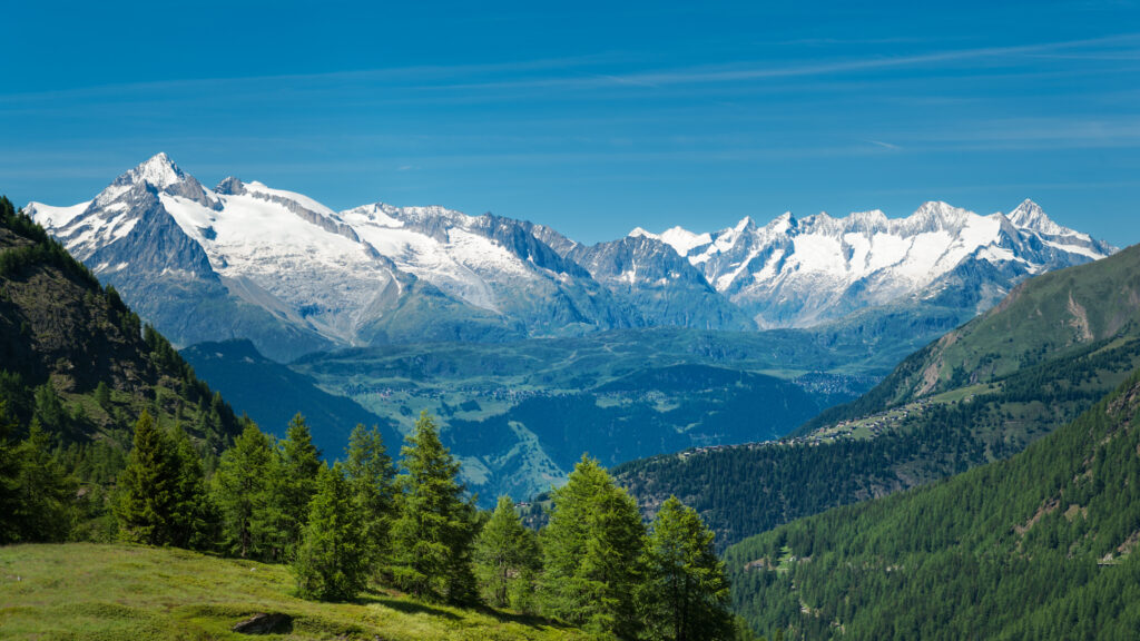
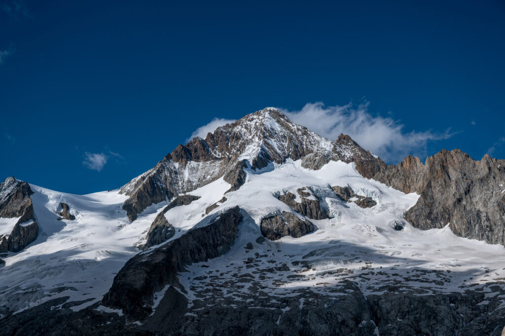
The Aletschhorn (4,193 m / 13,757 ft) stands at a geographic crossroads that no other Alpine 4,000m peak can match: it is the central summit of the Jungfrau-Aletsch UNESCO World Heritage region, surrounded by the largest concentration of glacial ice in the Alps. The Great Aletsch Glacier — 23 km long, 800 m deep at its thickest, containing 10 billion tonnes of ice — flows from the Jungfraujoch directly past the mountain’s northern flank. The Oberaletsch and Mittelaletsch glaciers flank it to the southwest and east. The Aletschhorn rises from this vast frozen landscape like a pyramid throne above the biggest river of ice in Europe.
The mountain holds two claims that define its character. First, it is “often thought to command the finest of all the panoramic views from Alpine summits” (Wikipedia, quoting established mountaineering tradition) — a view that encompasses the entire Bernese Alps chain northward (Eiger, Mönch, Jungfrau, Finsteraarhorn), the Pennine Alps southward (Matterhorn, Weisshorn, Dom, Monte Rosa), and Mont Blanc to the west. Second, it carries the reputation of being the coldest mountain in the entire Alps. Both claims are confirmed by Francis Fox Tuckett who, on his first ascent in 1859, took barometric measurements at the summit and specifically noted the icy temperature and ferocious wind that nearly knocked his party from the ridge.
Find Hotels, Flights & Trips for the World’s Best Hiking Destinations
The Global Summit Guide Travel Shop on Expedia — curated for outdoor adventurers, mountaineers, and serious hikers. Patagonia to the Alps. Nepal to the Rockies. Curated lodging for every region we cover.
Explore Travel Shop on Expedia →For mountaineers, the Aletschhorn is defined by its remoteness. SummitPost describes the mountain’s approaches as having “Himalayan dimensions and shapes” — vast flat glacier basins, long approaches on endless moraines, and huts placed so far from the summit and from civilisation that phone signal is absent all day. The SW Ridge Normal Route from the Oberaletsch Hütte involves a 6–8 hour ascent and a 5-hour descent, with a 200-metre roped descent onto the glacier at the start of the summit day that must be reversed at the end of it. This is not a mountain for the hurried. It rewards those who give it the time and preparation it demands.
Aletschhorn quick facts at a glance
| Category | Details |
|---|---|
| Elevation | 4,193 m / 13,757 ft |
| Location | Bernese Alps, Canton Valais, Switzerland — Jungfrau-Aletsch UNESCO World Heritage region |
| Rank | 2nd highest peak in the Bernese Alps (after Finsteraarhorn at 4,274 m) · Only higher Bernese Alps peak entirely in Valais |
| UNESCO Status | Within the Jungfrau-Aletsch UNESCO World Natural Heritage Site (designated 2001) |
| Panorama | “Often thought to command the finest of all the panoramic views from Alpine summits” |
| Temperature | Considered the coldest mountain in the entire Alps — noted by Tuckett on the first ascent, 1859 |
| Remoteness | Approaches described as “Himalayan dimensions and shapes” — long glacier approaches, remote huts, no phone signal on the mountain |
| The Glacier | Great Aletsch Glacier at its foot — 23 km · 800 m deep · 10 billion tonnes · Europe’s longest glacier |
| Normal Route | SW Ridge (Suedwestrippe, ZS−/AD) from Oberaletsch Hütte (2,640 m) via Belalp cable car |
| Hut Approach | Belalp cable car (Blatten near Naters) → Panoramaweg trail → Oberaletsch Hütte (3–4 hrs) |
| Hut to Summit | 6–8 hours; 1,700 m gain; 200 m descent then climb to get on/off glacier |
| All Routes | All routes are long and strenuous — no easy option exists on the Aletschhorn |
| Neighbors | Eiger, Mönch, Jungfrau ~10 km north; Finsteraarhorn to east; Bietschhorn to west |
| First Ascent | June 18, 1859 — Francis Fox Tuckett with guides J.J. Bennen, Victor Tairraz & P. Bohren |
| First Woman | 1863 — Emma Winkworth |
| Best Season | June – September |
Tuckett & Bennen, 1859 “the icy temperature and the very strong wind”
First ascent background — almost 50 years after the Jungfrau
The Aletschhorn was first climbed almost 50 years after the first ascent of the Jungfrau (1811) — a remarkable gap given its greater height than the Jungfrau and its prominent central position in the Bernese Alps. The reason is purely geographic: the Aletschhorn is remote. While the Jungfrau could be seen and approached from the densely populated valleys of the Bernese Oberland to the north, the Aletschhorn sat in the heart of a glacier world with no easy valley access. The first Jungfrau climbers in 1811 actually camped at the foot of the Aletschhorn — using the Aletschfirn as their base — on their way to the Jungfrau. They could see the Aletschhorn above them but had neither the time nor the objective to attempt it. The mountain waited 48 more years for its first ascent.
Francis Fox Tuckett — first ascent, June 18, 1859
Francis Fox Tuckett (1834–1913) was a Bristol-born businessman and Quaker who became one of the most prolific mountaineers of the Golden Age, making first ascents and new routes throughout the Alps and beyond. On the night before the first ascent, his party — Tuckett with guides J.J. Bennen, Victor Tairraz, and P. Bohren — passed the night in holes in the rocks above the Mittelaletsch Glacier on the east side of the mountain. At dawn on June 18, they started the ascent and reached the snow arête connecting the Dreieckhorn with the main peak. The passage along this arête, so early in the year before the snow consolidated, involved real danger: a slope of névé at 50° requiring careful step-cutting throughout. Tuckett, characteristically, brought a barometer and made scientific observations at the summit. He recorded “the icy temperature and the very strong wind, blowing the snow and threatening to knock over the climbers.” After reaching the summit, Tuckett separated from Bennen and descended via the north face with Bohren and Tairraz, while Bennen took a different descent line — a decision that reflects the mountain’s complex terrain and the freedom of movement experienced guides and capable clients brought to early Alpine ascents.
J.J. Bennen — two years before the Weisshorn, five years before his death
The guide J.J. Bennen on the Aletschhorn first ascent (1859) is the same J.J. Bennen who partnered John Tyndall on the first ascent of the Weisshorn two years later in 1861 — and who died in an avalanche on the Haut de Cry in February 1864. Bennen is by wide acclaim the greatest mountain guide of the Golden Age — his career concentrated into a single extraordinary decade (roughly 1855–1864) of first ascents, technical innovations, and guiding achievements that set the standard for the era. The Aletschhorn first ascent was part of an extraordinary sequence: Bennen was on the first ascent team of multiple major Alpine summits across the late 1850s and early 1860s before his death ended what would have been the most remarkable guiding career in history.
Emma Winkworth — first woman, 1863
Four years after the first ascent, Emma Winkworth — daughter of Thomas Thomasson — became the first woman to climb the Aletschhorn in 1863. Her ascent in the same year as the Jungfrau’s first female ascent (also 1863) reflects the extraordinary role women played in Golden Age alpinism — often at the forefront of first ascents, rarely credited in popular history.
Why the Aletschhorn is “thought to command the finest panoramic view”
The Aletschhorn’s central position is the key. It stands between the Bernese Alps chain (Eiger, Mönch, Jungfrau, Finsteraarhorn all visible to the north and northeast) and the Pennine Alps chain (Matterhorn, Weisshorn, Dom, Monte Rosa all visible to the south and southeast), with Mont Blanc visible to the west on clear days. The Finsteraarhorn (4,274 m, 10 km east) is the only summit in the entire Bernese Alps that is higher. From the Aletschhorn summit, almost every great Alpine peak from the Bernese Oberland to the Valais is visible simultaneously — an unobstructed 360-degree panorama that few mountains in the Alps can match by reason of their more marginal positioning in the chain.
The Great Aletsch Glacier Europe’s longest, at the mountain’s feet
The Great Aletsch Glacier — 23 km · 800 m deep · 10 billion tonnes · UNESCO World Heritage
The Great Aletsch Glacier is the largest and longest glacier in the Alps — by a significant margin. At 23 km in length, it is more than twice the length of any other Alpine glacier. It covers an area of 80 km² and contains an estimated 10 billion tonnes of ice. At its deepest point, the ice is 800 metres thick. The glacier flows from the Konkordiaplatz — the massive confluence of four glacier arms below the Jungfraujoch, called the “largest glacier gathering in the Alps” — down through 23 km of valley before terminating near Brig in the Rhone valley. The Massa River, which originates in the Aletsch Glacier, flows directly into the Rhône. The entire Jungfrau-Aletsch region was designated a UNESCO World Natural Heritage Site in 2001 — one of Europe’s largest protected Alpine areas.
- The Aletschhorn’s glacier neighbours: The Great Aletsch Glacier flows along the mountain’s northern flank (the Aletschfirn). The Oberaletsch Glacier lies to the southwest — the approach route from the Oberaletsch Hütte crosses its tongue. The Mittelaletsch Glacier lies to the east and provides an alternative approach via the Mittelaletsch Bivouac. Together, these three glaciers make the Aletschhorn the most glacier-encircled 4,000m peak in the Bernese Alps.
- Climate change and the approaches: The retreat of the Aletsch glaciers in recent decades has significantly affected the approach routes. The Oberaletsch Glacier tongue is now heavily debris-covered — what was once clean ice is now a moraine surface requiring navigation through rocks and scree for kilometres. The 200-metre descent from the Oberaletsch Hütte to the glacier via fixed ropes and ladders exists because the glacier has retreated below the hut’s level. Route conditions change year to year as the glaciers continue to retreat. Check current conditions with the hut warden before your ascent.
- Konkordiaplatz: The massive glacier junction below the Jungfraujoch visible on clear days from the Aletschhorn’s summit approaches — where the Jungfraufirn, Ewigschneefäld, and other glacier arms converge into a single vast ice river — is one of the great alpine spectacles. The Konkordiaplatz sits at approximately 2,700 m and was used as a base camp for the 1811 Jungfrau first ascent party who camped at the foot of the Aletschhorn.
Belalp & Blatten the gateway via cable car
The Aletschhorn is accessed from the Belalp ski resort area above the town of Blatten near Naters in the Upper Valais. Blatten and Naters are part of the Brig-Visp agglomeration at the Rhône valley floor — a gateway town served by the main Swiss rail line.
Getting to Blatten & Belalp
- By rail to Brig: Brig (Brig-Glis) is on the main Swiss SBB rail network — direct InterCity trains from Zürich (~2 hrs 15 min) and Geneva (~2 hrs 10 min). From Brig station, take a local bus or taxi to Blatten near Naters (approximately 10 km, 15 minutes).
- By car: From the A9 motorway (Rhône Valley), exit at Brig and follow signs to Naters and Blatten. Free parking is available at Egga on the road to Blatten (avoiding the higher parking charges) with a pleasant larch forest path leading up to the Hotel Belalp. Alternatively, paid parking at Blatten village.
- Belalp Cable Car (Luftseilbahn Blatten-Belalp): From Blatten, the cable car takes you to Belalp at 2,094 m — the high plateau resort with the historic Hotel Belalp. Operating hours: approximately 8:00 AM to 8:00 PM. One-way fare approximately CHF 20. The last car down at 8:00 PM is a strict constraint for summit day planning. Check current timetables before your trip: the last cable car governs your entire day.
- Alternative (no cable car): Strong parties can walk from Blatten/Egga to Belalp through larch forests (gaining ~750 m in ~1.5 hours), avoiding the cable car cost and schedule constraints. The larch forest approach is described as beautiful and gives a more complete mountain experience.
The Oberaletsch Hütte approach — the Panoramaweg
From Belalp (2,094 m), the approach trail to the Oberaletsch Hütte (2,640 m) follows the beautiful Panoramaweg — a high-level path along the meadow terrace on the left bank of the Oberaletsch Glacier with spectacular views across the glacier to the Nesthorn, Breithorn, and the Aletschhorn itself. The path crosses steep rocky cliff via a trail built with explosive charges in 2005 (the old glacier crossing is now awkward and dangerous due to ice retreat), includes an aerial suspension bridge over a glacial stream, and reaches the hut in approximately 3–4 hours from Belalp. The Aletschhorn does not come into full view until quite late on the approach.
All trails & routes on the Aletschhorn
The SAC and every guide service that operates on the Aletschhorn states the same warning: all routes are long and strenuous. There is no easy approach and no short day on this mountain. The Aletschhorn’s remoteness from any valley or mechanical uplift means that every route requires a serious multi-day commitment.
| # | Route | Grade | Character & Key Notes |
|---|---|---|---|
| 1 | SW Ridge Normal Route (Südwestrippe) | ZS− / AD | Standard summer route. Oberaletsch Hütte (2,640 m) → 200 m descent via fixed ropes/ladders to Oberaletsch Glacier → glacier tongue (debris-covered) → SW Ridge base → rock scrambling (II max) → glacier at 3,400 m → steep summit flank (35°+, safety poles) → summit. 6–8 hrs ascent; 5 hrs descent. 1,700 m gain from hut. Accessed via Belalp cable car. “Good rock” on lower ridge; reddish gneiss; grade never exceeds II. 3-day program recommended. |
| 2 | NE Ridge via Mittelaletsch Bivouac | AD | First ascent route (Tuckett, 1859). From Bettmeralp cable car: descend to Aletsch Glacier, cross to Mittelaletsch Glacier, ascend left side to Mittelaletsch Bivouac (4–5 hrs from Bettmeralp). Summit day via NE Ridge snow arête to Dreieckhorn connection → summit. Very long; very remote; 5–6 hrs + 4–5 hrs. Bivouac conditions can be basic. Equal or greater remoteness than SW Ridge approach. |
| 3 | NW Ridge (via Hollandia Hütte / Lötschenlücke) | AD+ | From the Hollandia Hütte (3,239 m) on the Lötschenlücke, west of the mountain. Less frequently climbed; useful only for the NW ridge. Long approach from Lötschen valley. Not the standard summer route. Winter/ski mountaineering potential. |
| 4 | North Face (Aletschfirn approach) | D · 50° ice | Steep north face above the Great Aletsch Glacier (Aletschfirn). Serious ice climbing objective. Approach from Jungfraujoch (by rail), then long descent and approach across the glacier. Significant objective danger. After summit, must ascend 500 m back to Jungfraujoch railway station on return — a major commitment. Rare. For experienced ice climbers. |
| 5 | SW Ridge in Winter / Ski | ZS / ski mountaineering | The SW Ridge is skiable in good snow conditions, though ski depots are used for the upper rocky sections. Access via Belalp lifts and the ski touring terrain above. Switzerland Tourism describes this as an ideal “first 4,000m peak” ski objective for experienced ski mountaineers. Guide essential. |
SW Ridge Normal Route & NE Ridge full route descriptions
SW Ridge — Normal Route (Südwestrippe)
- The pre-dawn departure and the 200 m glacier descent: Summit day starts at approximately 2:00–3:00 AM — unusually early even by alpine standards — because of the distance to be covered. The first challenge is not upward but downward: a 200-metre descent via fixed ropes and vertical ladders from the Oberaletsch Hütte down a steep rock face to the glacier below. The hut sits above the glacier because the ice has retreated far below its historical level. This descent is secured but requires full gear — harness, helmet, crampons ready. The ascent in reverse at day’s end, when parties are exhausted from 10–14 hours on the mountain, is described with conspiratorial good humour in multiple guides: “Don’t forget: there’s another 200-metre climb from the glacier up to the hut at the end.”
- Glacier tongue — debris-covered and route-finding required: At the base of the ropes, the Oberaletsch Glacier tongue is completely covered in glacial debris. What was once clean ice is now a kilometres-long field of moraine scree. Parties search for the best access route across this — a 2-km trudge on “fairly solid, but potentially icy, footing” as one alpinsight.com trip report describes it. Navigation here is not trivial in the dark; reflective markers on the glacier help guide the way.
- The moraine and SW Ridge base — rock scrambling begins: Above the glacier tongue, the route climbs steeply through moraine flanks to reach the base of the SW Ridge. A newly-built trail with permanent wands and markers leads up and left to a flat plateau at the ridge base. Above here, the SW Ridge itself begins — described as “entertaining rock scrambling” on good reddish gneiss. The grade never exceeds Class II on rock, but the exposure, altitude, distance, and accumulated fatigue make it demanding. “The astonishingly good rock leads along the ridge.”
- Reaching the glacier at 3,400 m — the upper ice flank: At approximately 3,400 m the route reaches the glacier on the upper mountain. From here, the final 450 m to the summit is steep ice and rock, requiring full crampon discipline. Safety poles are fixed on the steepest section of the summit flank (35°+) to assist movement and provide protection points. Clip into the poles; do not trust luck on this section.
- Summit (4,193 m) — the finest Alpine panorama: The summit view is justly celebrated. North: Eiger, Mönch, Jungfrau, Schreckhorn, Finsteraarhorn — the full Bernese Oberland glacier world. South: Matterhorn, Weisshorn, Dom, Breithorn, Monte Rosa. West: Mont Blanc visible on clear days. The view is remarkable for its completeness — the Aletschhorn’s central position between the Bernese and Pennine chains means both great Alpine ridges are simultaneously visible. Below, the full length of the Great Aletsch Glacier unfolds northward — a 23 km river of ice ending 23 km away near Brig.
- Descent — the 8:00 PM cable car constraint: Descend the exact ascent route. The 200 m re-ascent via fixed ropes to the hut at day’s end is the final test. From the hut, the return to Belalp via the Panoramaweg takes 3–4 hours — and the last Belalp cable car descends at approximately 8:00 PM. This governs the entire day’s timing. A 3-day program with two nights at the Oberaletsch Hütte removes this pressure and allows a leisurely final day walk back to Belalp and the cable car.
NE Ridge — First Ascent Route (Tuckett, 1859)
- Tuckett’s 1859 approach: The first ascent party bivouacked in “holes in the rocks” above the Mittelaletsch Glacier the night before their summit, starting the ascent at dawn on June 18. The approach from the Mittelaletsch side across the vast Aletsch Glacier system is what gives the route its Himalayan character — vast, flat glacier basins, minimal landmarks, and a sense of distance and scale that is almost without parallel in the Alps.
- Modern approach from Bettmeralp: Take the Bettmeralp cable car from the Rhone valley. From the Bettmeralp station, descend to the Aletsch Glacier, cross it to the opposite side, reach the Mittelaletsch Glacier, and ascend the glacier’s left side following cairns to the Mittelaletsch Bivouac. The bivouac is small, basic, and remote — basic sleeping facilities and no staffing. Total approach: 4–5 hours from Bettmeralp.
- Summit day via NE Ridge: From the bivouac, ascend the NE ridge to the snow arête that connects the Dreieckhorn with the main summit. The arête in early season (as Tuckett experienced) can be at 50° and demanding step-cutting; in summer it is more consolidated. 5–6 hours from bivouac. The views on this approach are extraordinary — looking directly up the Great Aletsch Glacier toward the Jungfraujoch.
- Why “Himalayan dimensions”: The Aletsch approaches are described in multiple sources as having Himalayan scale precisely because of routes like this one. The glacier basins are flat and immense. The huts and bivouacs are placed far from both the summit and from any road. Phone signal is absent all day. The sense of being in a truly remote, self-sufficient alpine environment — rare in a country as developed as Switzerland — is the Aletschhorn’s most distinctive character.
Recommended three-day SW Ridge program sample itinerary
The three-day program is strongly recommended over two days — it gives two nights at the Oberaletsch Hütte, removing the cable car time pressure and allowing proper acclimatization and rest for the long summit day.
Day 1 — Belalp to Oberaletsch Hütte
Day 2, ~2:00 AM — Pre-dawn summit push
Day 3 morning — Oberaletsch Hütte to Belalp & cable car
Oberaletsch Hütte & no climbing permits required hut and access
| Resource | Details | Cost / Booking |
|---|---|---|
| Climbing Permit | No permit required for any Aletschhorn route | Free |
| Oberaletsch Hütte (2,640 m) | SAC hut (Section Chasseral); 58 places new hut + 12 old; open spring and summer; multilingual staff (German, English, French, Italian, Japanese). Book in advance for July–August. Phone: +41 27 927 17 67 | ~CHF 60–80/person half board · Book via sac-cas.ch → |
| Mittelaletsch Bivouac | Small basic bivouac on Mittelaletsch Glacier east side — for NE Ridge approach. No warden; self-catering. | Low / donation |
| Hollandia Hütte (3,239 m) | On the Lötschenlücke west of mountain — used for NW ridge approach and Bernese Oberland glacier traverses | Book via SAC |
| Belalp Cable Car | Blatten near Naters to Belalp (2,094 m). Operating ~8:00 AM to 8:00 PM. Last car down is a hard constraint for summit day timing. | ~CHF 20 one-way · Check timetable at belalp.ch → |
| Bettmeralp Cable Car | For Mittelaletsch Bivouac approach from Bettmeralp resort | Local resort pricing |
Best time to climb the Aletschhorn seasonal planning
| Season | Window | Pros | Watch-outs |
|---|---|---|---|
| Summer ★ Primary | Late June – mid-September | Oberaletsch Hütte fully open; SW Ridge accessible; consolidated snow on upper flank; long days for the very long summit push; stunning wildflowers on Panoramaweg approach | Extremely cold summit even in summer — warmest gear required; afternoon storms possible; debris-covered glacier tongue awkward; glacier conditions change annually; phone signal absent all day |
| Early June / Winter-Spring Ski | May–June | Excellent ski mountaineering conditions; clean snow on SW Ridge; Belalp lifts often operational for ski access | Hut may not be fully staffed; SW Ridge more demanding in deep snow; crevasse bridges fragile in spring |
| Late September onward | After mid-September | Possible in stable high-pressure conditions | Hut closing; new snowfall; shorter days; SW Ridge icy |
Essential gear for the Aletschhorn
Technical equipment
- Crampons — mandatory throughout
- Ice axe — mandatory (35°+ summit flank)
- Harness + belay device (200 m fixed rope descent)
- Helmet — mandatory (glacier & upper rock)
- Rope: 30–50 m shared in team
- Prussik cords (glacier crevasse rescue)
- Glacier glasses (UV at 4,193 m in a glacier world)
Alpine conditions clothing
- Maximum warm layers — coldest mountain in the Alps
- Down jacket (critical; summit can be brutally cold)
- Waterproof hardshell jacket + pants
- Expedition-weight gloves + liner gloves
- Balaclava + warm hat + neckwarmer
- Stiff alpine boots (crampon-compatible)
- Sunscreen SPF 50+ (glacier UV reflection)
Remote mountain kit
- Sleeping bag liner (hut provides blankets)
- High-calorie food for 10–14 hour summit day
- 1.5–2 litres water minimum
- Emergency bivouac sack (remoteness means rescue takes time)
- Full ten essentials
- Swiss Franc cash for hut
Navigation (critical)
- Headlamp + spare batteries (2:00 AM start)
- GPS with downloaded SW Ridge route
- Note: no phone signal all day on the mountain
- Satellite communicator — strongly recommended
- Paper topo map (Swiss 1:25,000)
- SAC Route Portal offline data
Difficulty & safety notes risk and preparedness
Not for beginners — its difficulty comes from scale, remoteness, and cold
The SW Ridge is graded ZS− / AD — the technical difficulty (max Class II on rock, 35° on the upper flank) is lower than the Weisshorn or Piz Bernina. But the Aletschhorn is emphatically not a beginner objective. Its challenges are different in kind:
- Extreme cold — the coldest mountain in the Alps: Dress for conditions colder than any other 4,000m objective. Multiple accounts describe the summit as ferociously windy and bitterly cold even in summer. Tuckett’s 1859 barometric readings confirmed the icy temperature; it remains a consistent characteristic. Every climber on the Aletschhorn should have more insulation than they think they need.
- Complete remoteness and no phone signal: Phone signal is absent for the entire summit day — an unusual situation in Switzerland. All communications should be via satellite communicator. Self-sufficiency is essential; rescue takes time and distance matters here. The mountain genuinely feels “Himalayan” in its isolation for a Swiss alpine objective.
- The 200 m fixed rope section: Descending 200 m on vertical fixed ropes and ladders at the start of a 6–8 hour summit push — and then reversing this at the end of an exhausting day — requires full gear and careful technique. Do not underestimate this section. It is harder in both directions when you are tired.
- Cable car timing: The 8:00 PM last cable car from Belalp creates real time pressure on a 2-day program. A missed cable car means a very long walk down to Blatten in the dark. The 3-day program eliminates this risk entirely and is the safer choice.
- Route-finding on the glacier tongue: The debris-covered Oberaletsch Glacier is confusing in the dark and the route changes annually as the ice retreats. Study the most recent hut trip reports and speak with the hut warden about the current best line across the glacier tongue.
- Afternoon storms: Standard Alpine summer pattern. Summit before noon. On a mountain this remote, being caught in a severe afternoon storm on the upper ridge is a serious emergency.
Aletschhorn guide services guided programs
High Mountain Guides has published a detailed trip report and runs guided Aletschhorn SW Ridge programs from Belalp. Their 2022 report explicitly warns that “a full mountain background is mandatory” and describes the Himalayan-scale remoteness of the approaches. They combine the Aletschhorn with nearby objectives like the Mittellegi Ridge on the Eiger for multi-day Bernese programs.
Visit Website →The SAC Route Portal provides the authoritative route description for the Aletschhorn SW Ridge Normal Route and NE Ridge. Local IFMGA-certified guides in the Valais (Brig, Naters area) and Bernese Oberland can be found through the SAC guide network.
SAC Route Portal →Frequently asked questions about the Aletschhorn
Map of the Aletschhorn & live weather live conditions
Summit location and live weather from the Aletschhorn’s coordinates (46.460°N, 8.000°E). The map shows the summit, Belalp / Blatten near Naters (cable car access), and the Oberaletsch Hütte area above the Oberaletsch Glacier.
Aletschhorn — summit conditions
4,193 m / 13,757 ft · Coldest mountain in the Alps · Live from summit coordinates
At-a-glance planning snapshot summary
| Mountain | Aletschhorn — “finest panoramic view from any Alpine summit” |
| Elevation | 4,193 m / 13,757 ft — 2nd highest in Bernese Alps |
| Location | Bernese Alps, Canton Valais — UNESCO Jungfrau-Aletsch World Heritage region |
| Glacier | Great Aletsch Glacier at its foot — Europe’s longest: 23 km, 800 m deep, 10 billion tonnes |
| Cold | Coldest mountain in the Alps — pack maximum warmth regardless of season |
| Remoteness | “Himalayan dimensions” — no phone signal all day — satellite communicator essential |
| Normal Route | SW Ridge (ZS− / AD) via Oberaletsch Hütte — 6–8 hrs — 200 m fixed rope descent to glacier at start |
| Cable Car Warning | Belalp last car ~8:00 PM — 3-day program avoids this timing pressure |
| Programme | 3 days recommended: Belalp → Hut → Summit+Hut → Belalp |
| Permit | None required |
| Best Season | Late June – mid-September |
| First Ascent | June 18, 1859 — Francis Fox Tuckett with J.J. Bennen, V. Tairraz & P. Bohren |
| First Woman | 1863 — Emma Winkworth |
| Bennen connection | J.J. Bennen: Aletschhorn 1859 → Weisshorn 1861 → killed Haut de Cry 1864 |
Related peaks continue exploring
The complete Aletschhorn climbing reference everything climbers need to know
The Aletschhorn at 4,194 meters is the second-highest peak in the Bernese Alps and one of the most aesthetic 4,000-meter mountains in Switzerland. Despite its dramatic stature dominating the upper Aletsch Glacier — the longest glacier in the European Alps at 23 kilometers — the Aletschhorn receives a fraction of the climbing traffic that the more famous Jungfrau and Mönch attract. This makes it one of the most rewarding “quieter” 4000ers for climbers who want serious alpine character without the crowds.
The peak sits within the UNESCO World Heritage Jungfrau-Aletsch protected area, surrounded by the Mittelaletschfirn, Oberaletschfirn, and the main Aletsch Glacier. Its position deep in the Bernese Oberland means approaches are long — typically 4-6 hours from the nearest hut — which is part of why the peak sees fewer ascents than the Jungfrau region’s more accessible summits. Climbers attempting the Aletschhorn should expect a genuine multi-day alpine commitment rather than a quick weekend objective.
| Detail | Aletschhorn specifics |
|---|---|
| Elevation | 4,194 m (13,760 ft) |
| Bernese Alps ranking | 2nd highest peak (after Finsteraarhorn 4,274m) |
| Switzerland ranking | Approximately 9th highest |
| European Alps ranking | Among the 82 official 4000ers |
| Prominence | 1,025 m |
| First ascent | June 18, 1859 (Leslie Stephen and party) |
| Standard route grade | PD+ (peu difficile plus) |
| Typical climbing duration | 2-3 days from valley |
| Standard base hut | Hollandiahütte (3,235m) or Mittelaletschbiwak (3,013m) |
| Nearest cable car access | Jungfraujoch (3,463m) via Kleine Scheidegg |
| Best climbing season | Late June through mid-September |
| Approximate annual ascents | 200-400 climbers (estimate) |
| UNESCO protected area | Yes — Jungfrau-Aletsch World Heritage Site |
Climbing routes on the Aletschhorn main lines and grades
The Aletschhorn offers several established routes ranging from the classic Hasler Rib at PD+ to harder technical lines on the northeast face. The standard ascent uses the south or southwest flanks via the Hollandiahütte or Mittelaletschbiwak. Climbers should select their route based on conditions, experience, and which hut they’re using as the base.
South Flank (Standard Route)
The most popular route, accessed from the Hollandiahütte via the upper Mittelaletschfirn. The route involves moderate glacier travel with crevasse hazard, a steepening snow slope to the southwest ridge, and a final summit ridge with mixed snow and rock at moderate angle. No fixed protection — climbers move on rope team. Best conditions are firm late-June through August before excessive crevasse opening.
Hasler Rib (Southwest Ridge)
The classic harder line on the Aletschhorn, first climbed by the Hasler party. The Southwest Ridge offers sustained mixed climbing with rock pitches up to grade IV and snow/ice sections. The route is more committing than the South Flank — once on the upper ridge, retreat options are limited. Best suited to climbers with prior AD-grade alpine experience. Conditions matter dramatically; iced rock can elevate the climbing difficulty significantly.
Northeast Face Routes
The northeast face has several technical lines that see infrequent ascents. These routes involve steep ice (up to 60°+), mixed terrain, and serious objective hazard from seracs and falling rock. Recommended only for experienced alpine climbers with strong ice-climbing background. The faces have changed substantially as glaciers retreat — modern conditions can differ meaningfully from historic route descriptions.
The standard South Flank is the right choice for most parties. Climate change has affected several Alps 4000ers’ historic routes — opening crevasses, exposed rock that was previously snow-covered, and shifting bergschrunds. Always check recent conditions reports with the Hollandiahütte warden before departure. The route may be different from descriptions in older guidebooks.
When to climb the Aletschhorn seasonal conditions
The Aletschhorn climbing season is relatively narrow compared to lower Alps peaks. The mountain’s altitude (4,194m) keeps it firmly in winter conditions for most of the year. Most parties target the late summer window when bergschrunds are stable and the south flank snow has consolidated.
Conditions to monitor before climbing
- Bergschrund status: The bergschrund crossing on the south flank can become impassable in late August some years. Check recent reports.
- Snow line: In hot summers, the snow line can rise above 3,500m, exposing rock and ice that’s normally snow-covered.
- Hut availability: The Hollandiahütte has limited capacity and requires advance booking, especially in peak July-August window.
- Weather windows: Bernese Oberland weather can change rapidly. Plan for 2-day weather windows minimum for the summit attempt.
- Glacier conditions: The approach across the Aletschfirn and Mittelaletschfirn requires assessment of crevasse coverage and snow bridges.
Gear for the Aletschhorn what you actually need
The Aletschhorn’s standard route is moderate alpine grade requiring full glacier travel and snow climbing equipment but not technical rock or ice climbing gear. The harder Hasler Rib route adds technical rock and mixed climbing protection. Below is the gear list for the standard South Flank route — adjust upward for technical routes.
Climbing hardware
- Crampons (technical mountaineering grade C2 / B2-B3 boots)
- Ice axe (60-65cm general mountaineering)
- Climbing harness
- Helmet (mandatory)
- 2 ice screws (party, for crevasse rescue)
- 2-3 prusik loops or mechanical ascenders
- Locking carabiners (3-4 minimum)
- Single 30-50m rope (8.5-9.5mm)
- Slings, belay device
Clothing system
- Synthetic base layers
- Mid-weight fleece or softshell
- Down or synthetic insulating jacket
- Hardshell (Gore-Tex or equivalent)
- Climbing pants (softshell preferred)
- Hardshell pants for storms
- Gloves: lightweight liner + insulated climbing
- Buff/neck gaiter, balaclava
- Mountaineering boots B2-B3 rated
Navigation & safety
- Map (Swiss 1:25,000 sheet 264S Jungfrau)
- Compass and GPS
- Altimeter (watch or dedicated)
- Headlamp + spare batteries
- Sunglasses (Cat 4 glacier rating)
- Ski goggles (storm backup)
- SPF 50+ sunscreen, lip balm
- First aid kit with altitude meds
- Mobile phone (limited coverage)
Personal & overnight
- 40-50L climbing pack
- 1.5-2L water capacity per day
- High-energy mountain food
- Hut shoes/slippers (most huts require)
- Sleeping bag liner (hut sleeping)
- Lightweight camp clothing
- Cash for hut payment (CHF preferred)
- Identity documents
- Camera and spare battery
For comprehensive gear selection guidance covering all Alps 4000ers, see our crampons decision guide and ice axe technique guide.
Common mistakes on the Aletschhorn honest safety considerations
The Aletschhorn has produced several serious accidents over the years, almost always related to the same recurring mistakes. These aren’t theoretical risks — they’re the documented patterns from Swiss Alpine Club incident reports and rescue statistics.
Underestimating the approach distance
Parties arriving at the Hollandiahütte the same day as their summit attempt frequently fail or struggle. The approach itself involves 4-6 hours of glaciated terrain. Plan to arrive at the hut by mid-afternoon, rest properly, and start summit day from rested condition. The hut isn’t a quick drive-up access point.
Climbing in marginal weather windows
The Bernese Oberland weather can deteriorate from sunny to whiteout in 90 minutes. Climbers who push for the summit in marginal conditions have died in retreat. If forecasts show afternoon thunderstorms or rapidly building cloud, abandon the attempt. The mountain will be there next season.
Inadequate crevasse rescue preparation
The Aletschfirn and Mittelaletschfirn have substantial crevasse hazard. Parties without practiced crevasse rescue protocols are at real risk. Every team member must know how to construct a 3:1 mechanical advantage system, deploy ascenders for self-rescue, and execute a coordinated rescue while the rest of the team holds the load. Practice before the trip, not on the mountain.
Solo or short-rope travel on the glacier
Despite the moderate grade, solo climbers on the Aletschhorn glaciers face genuinely lethal exposure. Every season produces incidents of climbers falling into crevasses while traveling unroped or with rope too long between teammates. Rope team distance should be 8-15 meters between climbers, never longer.
Starting too late from the hut
Standard departure time from the Hollandiahütte is between 3:00 and 4:00 AM. Later starts mean climbing the summit ridge in deteriorating afternoon snow, dealing with afternoon weather buildup, and descending warmed-up crevasse bridges. The early start isn’t optional cultural tradition; it’s safety protocol.
How the Aletschhorn compares vs other Alps 4000ers
The Aletschhorn sits in a specific niche among the 82 official 4000-meter peaks of the European Alps. Understanding where it fits relative to better-known peaks helps climbers calibrate expectations:
| Peak | Elevation | Standard grade | Climbing days | Crowd level |
|---|---|---|---|---|
| Mont Blanc | 4,810 m | PD | 2-3 days | Very busy |
| Matterhorn | 4,478 m | AD | 2-3 days | Very busy |
| Finsteraarhorn | 4,274 m | AD- | 2-3 days | Moderate |
| Jungfrau | 4,158 m | PD+ | 1-2 days | Busy |
| Mönch | 4,107 m | PD | 1 day | Busy |
| Aletschhorn | 4,194 m | PD+ | 2-3 days | Quiet |
| Aletschhorn (Hasler) | 4,194 m | AD | 2-3 days | Very quiet |
| Eiger Mittellegi | 3,970 m | AD+ | 2-3 days | Busy |
| Weisshorn | 4,506 m | AD | 2-3 days | Moderate |
The Aletschhorn fills the specific role of a “quiet PD+ 4000er” — comparable in difficulty to the Jungfrau but with dramatically fewer climbers. For climbers prioritizing solitude over absolute fame, this is exactly the right choice. The broader context of major Alps peaks is in our greatest mountains in the Alps ranking.
Climbers who have already done Mont Blanc and Jungfrau and want a less-crowded 4000m experience with similar technical difficulty. The mountain rewards self-sufficient parties willing to commit to a 2-3 day trip rather than a quick weekend objective. For climbers building toward the full 82 Alps 4000ers, the Aletschhorn is one of the more rewarding ticks on the list — a real summit experience without the queue.
Aletschhorn FAQ common questions answered
The Aletschhorn’s standard South Flank route is graded PD+ (peu difficile plus) — moderate alpine difficulty requiring glacier travel skills, crampons, ice axe, and rope team competence. The route involves no technical rock or ice climbing but covers substantial glaciated terrain with real crevasse hazard. The harder Hasler Rib (Southwest Ridge) is graded AD with rock pitches up to grade IV. For climbers with prior glaciated mountaineering experience on peaks like Mont Blanc or the Jungfrau, the Aletschhorn is a reasonable next-step objective.
No — the Aletschhorn cannot realistically be climbed in a single day from valley level. The approach to the standard base hut (Hollandiahütte at 3,235m) requires 4-6 hours of glaciated approach travel. Most parties allocate 2-3 days total: travel day to the hut, summit day, and return. Some very fit parties combine the summit day with descent to the valley, but this makes for an exceptionally long day (14-18 hours from hut). The two-day standard is recommended.
The Hollandiahütte at 3,235 meters is the standard base for the Aletschhorn standard South Flank route. The hut is operated by the Swiss Alpine Club and requires advance booking during peak season. Alternative options include the Mittelaletschbiwak (3,013m) for the Hasler Rib route, and the Konkordiahütte (2,850m) for variations approaching from the main Aletsch Glacier. The Hollandiahütte is the right choice for most climbers attempting the standard route.
A guide is not required for the Aletschhorn but is recommended for climbers without prior glaciated alpine experience. The mountain involves real crevasse hazard, route-finding challenges through complex glacial terrain, and altitude that affects decision-making. Swiss UIAGM-certified guides typically charge 800-1,200 CHF per day for the Aletschhorn. For experienced climbers with prior Mont Blanc or Jungfrau-grade experience, the standard route can be climbed competently without a guide given proper preparation, conditions assessment, and a competent rope team.
A self-guided Aletschhorn climb typically costs 200-400 CHF per person for the 2-3 day trip — primarily hut fees (60-90 CHF per night), cable car access, and food. A guided ascent costs 1,500-2,500 CHF per person for a 2-3 day program. International travelers should add flights to Zurich or Geneva (typically 600-1,500 USD from major cities) and ground transport to the Bernese Oberland. The Aletschhorn is dramatically cheaper than guided expeditions to major peaks elsewhere in the Alps thanks to Swiss alpine infrastructure efficiency.
Summit success rates on the Aletschhorn are not officially tracked the way they are on commercial Himalayan peaks. Based on Swiss Alpine Club records and guide reports, parties on the standard route in good conditions have summit success rates of approximately 70-85%. Failure is most commonly weather-driven rather than fitness or technical. The Hasler Rib has lower success rates around 50-65% due to higher technical demands and condition-sensitivity. Most failed attempts are decisions to turn back rather than incidents.
The Aletschhorn pairs naturally with other Bernese Oberland 4000ers for a multi-peak trip. Climbers can combine the Aletschhorn with the Jungfrau (4,158m), Mönch (4,107m), and Finsteraarhorn (4,274m) over a 7-10 day expedition based out of the Konkordiahütte or Hollandiahütte. The Aletschhorn is also commonly climbed before or after Mont Blanc as part of a broader Western Alps tour, taking advantage of the same gear and acclimatization. For the broader Alps 4000ers ranking, see our greatest mountains in the Alps guide.
Related Aletschhorn resources extend your research
The Aletschhorn fits into our broader Alps and European mountaineering coverage. These linked resources provide additional context for planning your climb and for understanding the Aletschhorn’s place in the wider Alps mountaineering landscape:
Was this helpful?
🏔Related peaks nearby
🧭Explore & compare
Global Summit Guide is an independent mountaineering resource founded in 2026. The team combines first-hand trekking and climbing experience with in-depth research and professional health and nutrition review to help climbers choose objectives, prepare properly, and stay safe.
Health, altitude, and nutrition content is reviewed by Taylor Ludlow (Registered Nurse) and Brigg Hoopes (Nutritionist).
What We Don't Know Yet
Mountain information changes quickly. This box explains the limits of what this page can responsibly promise.
- Weather, snowpack, avalanche risk, road access, and route conditions can change quickly and may be different on your climbing dates.
- Route conditions, trailhead access, crevasse exposure, stream crossings, and rescue access may vary from published planning guidance.
- Visa, passport, vaccination, border, insurance, and local transportation rules may change before your trip.
Verify current conditions with official land managers, guide services, local forecasts, and current route reports before booking or climbing.
Part of this Global Summit Guide cluster
Explore the complete Mountains guide for more context, routes, planning links, and related resources.
Mountaineering, rock and ice climbing, glacier travel, and high-altitude activity are inherently dangerous and can result in serious injury or death. The information on Global Summit Guide is provided for general informational and educational purposes only and is not a substitute for professional instruction, qualified guiding, proper equipment, or your own judgment and experience.
Route conditions, weather, snowpack, permits, regulations, and hazards change constantly and may differ from what is described here. Details may be incomplete, out of date, or contain errors. Always verify current information with local authorities, certified guides, and official sources before making any decision in the mountains.
Nothing on this site is medical, legal, or financial advice. Our fitness, acclimatization, altitude, and nutrition content is general in nature; consult a qualified physician before beginning any strenuous exercise program or exposing yourself to high altitude.
You are solely responsible for your own safety and decisions. To the fullest extent permitted by law, Global Summit Guide and its team accept no liability for any loss, injury, damage, or expense arising from use of, or reliance on, this information. By using this site you acknowledge these risks and accept these terms.
Some links on this site may be affiliate links. If you buy through them we may earn a small commission at no extra cost to you; this never affects our recommendations.
Global Summit Guide recommendation path
Next Best Mountain to Research
Use these recommendations to continue the right planning path instead of stopping on one page.
Use current permit, weather, route, and operator information before booking or climbing.