
Last updated May 25, 2026
Climbing Weisshorn 2026: The King of the Alps, Switzerland’s 4th-Highest Summit, the East Ridge Normal Route from Randa & the Three Classic Ridges
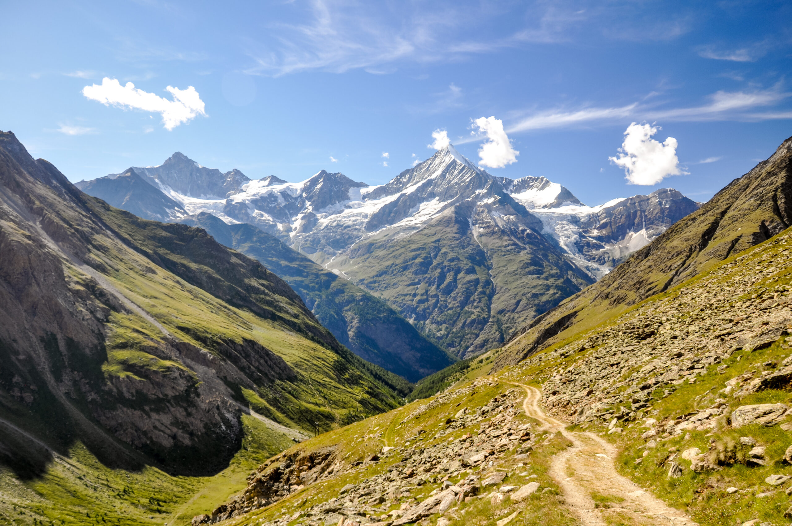
At 4,506 meters, Weisshorn rises as one of the most beautiful and serious mountains in the Swiss Alps. The isolated white pyramid earns the title “King of the Alps” and ranks among the hardest 4,000m peaks to climb. The mountain stands almost completely alone in the Valais Alps with its constantly snow-covered northeast face that gives the peak its name (“white horn”). The AD-grade East Ridge normal route from the Weisshornhütte, the long North Ridge over Bishorn from Zinal, and the connoisseurs’ South Ridge / Schalligrat all deserve consideration. Add in the 1861 first ascent by John Tyndall. The complete 2026 climbing guide follows.
Weisshorn occupies a particular position in Alpine mountaineering culture. The mountain isn’t the highest in Switzerland — Dufourspitze claims that title at 4,634m, just 128 meters taller. It isn’t even the most famous in the Valais Alps — Matterhorn holds that crown with its iconic pyramidal silhouette and global recognition. What Weisshorn holds, definitively, is reputation as the “King of the Alps.” The title is earned through several combined elements. These include extreme isolation, distinctive triangular pyramid shape, technical difficulty exceeding most other 4,000m peaks, and the genuine respect accorded by experienced alpinists worldwide. The peak stands almost completely alone in the Valais Alps, rising as a distinctive white pyramid visible from across the region. The name “Weisshorn” means “white horn” — referring to the constantly snow-covered northeast face that gives the mountain its iconic appearance from the mountain village of Randa in the Matter Valley below.
The mountain stands in the Valais Alps of southwestern Switzerland, in canton Valais — the same canton home to the Matterhorn, Dufourspitze, and the entire Pennine Alps cluster of major 4,000m peaks. Weisshorn is the 4th-highest summit entirely within Switzerland after Dufourspitze (4,634m), Dom (4,545m), and Liskamm (4,527m). The peak’s geographic isolation distinguishes it from neighboring 4,000m peaks. While Dufourspitze sits within the Monte Rosa massif and Matterhorn anchors its own ridge cluster, Weisshorn rises alone — separated from surrounding peaks by deep valleys and significant horizontal distance. The mountain features three classic ridges that form its triangular pyramid shape. First, the East Ridge (Ostgrat — the normal route). Second, the North Ridge which traverses over Bishorn (4,153m). Finally, the South Ridge — the famous Schalligrat. Each ridge offers a distinct climbing experience, with each requiring genuine alpine competence.
The climbing itself sets Weisshorn apart from peer Alpine 4,000m peaks. The standard East Ridge route is rated AD (Assez Difficile) on the French Alpine scale — significantly harder than the normal routes on most other 4,000m Alpine peaks. The Mountain Project assessment notes definitively that “the normal route is considerably more difficult than the normal routes on most other 4000m peaks.” The route demands sustained mixed climbing competence. Rock, snow, and ice sections combine across exposed ridges. The 11-12 hour summit day from the Weisshornhütte tests both technical skill and endurance. The mountain is widely considered one of the hardest 4,000m peaks to climb in the entire Alps. Climbers approaching Weisshorn should respect its serious nature — this isn’t an introductory 4,000m peak but rather a graduation objective for experienced alpinists ready to climb at a higher difficulty grade.
Find Hotels, Flights & Trips for the World’s Best Hiking Destinations
The Global Summit Guide Travel Shop on Expedia — curated for outdoor adventurers, mountaineers, and serious hikers. Patagonia to the Alps. Nepal to the Rockies. Curated lodging for every region we cover.
Explore Travel Shop on Expedia →This guide covers what you need to climb Weisshorn in 2026. The East Ridge standard route from the Weisshornhütte above Randa in detail. The North Ridge over Bishorn — a major 4,000er in its own right — providing the long approach from Zinal via Cabane de Tracuit. The famous South Ridge / Schalligrat — the connoisseurs’ choice but with access challenges via the unstable Schallihorn traverse where multiple fatalities have occurred. The 1861 first ascent by John Tyndall and Johann Joseph Bennen during the Golden Age of Alpinism. Weisshorn vs Matterhorn comparison — how Switzerland’s two iconic Valais 4,000m peaks differ in character, difficulty, and climbing experience. Mountain hut culture and Swiss Alpine Club (SAC) member discounts. Costs in CHF and EUR. And honest assessment of who should attempt this peak — because Weisshorn rewards genuine alpine competence and punishes climbers without the necessary foundation.
Weisshorn At a Glance
The essential reference facts for Weisshorn. Detailed sections follow below.
| Summit elevation | 4,506 m (14,783 ft) — some sources cite 4,505 m depending on measurement |
|---|---|
| Name meaning | “Weisshorn” = “white horn” — from constantly snow-covered NE face |
| Location | Valais Alps, canton Valais, southwestern Switzerland |
| Coordinates | 46.1067°N, 7.7158°E |
| Switzerland ranking | 4th highest summit entirely in Switzerland |
| Mountain range | Valais Alps (Pennine Alps) |
| Distinctive feature | Isolated triangular pyramid; “King of the Alps” reputation |
| Three classic ridges | East Ridge (normal); North Ridge (via Bishorn); South Ridge (Schalligrat) |
| First ascent | August 19, 1861 — John Tyndall, Johann Joseph Bennen & Ulrich Wenger via East Ridge |
| Standard route | East Ridge (Ostgrat) from Weisshornhütte |
| Standard difficulty | AD (Assez Difficile) — significantly harder than most 4,000m peaks’ normal routes |
| Difficulty rating | 155 difficulty score (Alpine Guides scale) |
| Summit day length | 11-12 hours round trip from Weisshornhütte |
| Approach base | Randa (1,407 m) — mountain village in Matter Valley |
| Standard hut | Weisshornhütte (2,932 m) — SAC hut, 30 places |
| Approach to hut | 4-4.5 hours from Randa; 1,700m elevation gain |
| North Ridge hut | Cabane de Tracuit (3,256 m) — SAC hut, 140 places (from Zinal) |
| South Ridge bivouac | Schalijoch Biwak (3,765 m) — SAC hut, 8 places (access difficult) |
| Bishorn connection | Bishorn (4,153 m) is a 4,000er in its own right on N ridge approach |
| Trip duration | 2-3 days typical with overnight at mountain hut |
| Best season | Late June to mid-September (peak mid-July to August) |
| 2026 guided cost | CHF 1,800-3,800 per person (1:1 guide ratio essential) |
| Gateway towns | Randa (Matter Valley); Tasch; Zinal (for North Ridge) |
| Nearest airport | Geneva (GVA) ~3 hours by train; Zurich (ZRH) ~4 hours |
Weisshorn is among the hardest 4,000m peaks in the Alps — appropriate only for experienced alpinists. The standard East Ridge route at AD grade is considerably more difficult than the normal routes on most other 4,000m Alpine peaks including the Matterhorn Hornli Ridge. The route demands sustained mixed climbing competence with rock, snow, and ice sections combined across exposed ridges throughout the 11-12 hour summit day. The South Ridge (Schalligrat) has seen multiple fatal accidents on the Schallihorn traverse approach. Climbers without prior 4,000m peak experience, sustained mixed climbing competence at AD grade, and excellent fitness should NOT attempt Weisshorn. The peak is widely considered a graduation objective from harder Alpine peaks rather than an introductory 4,000m climb. IFMGA-certified Swiss guides typically require 1:1 client-to-guide ratio for safety on the route. Climbers should build experience on Monte Rosa Dufourspitze, Mont Blanc, or the Matterhorn Hornli Ridge before attempting Weisshorn.
Why Weisshorn Earns the “King of the Alps” Title
Weisshorn occupies a particular position in European mountaineering culture. The mountain combines four distinguishing elements. First, status as the most isolated and beautiful pyramid in the Valais Alps. Second, technical difficulty exceeding most other 4,000m peaks including the famous Matterhorn. Third, historic significance as one of the iconic Golden Age first ascents. Finally, the genuine respect accorded by experienced alpinists who consider Weisshorn among the most rewarding 4,000m summits in the entire Alps. The combination earns the title “King of the Alps” — not as marketing but as recognition from the alpine climbing community.
The Isolated White Pyramid
Few mountains anywhere match Weisshorn for distinctive isolated profile. The peak rises almost completely alone above the Valais Alps with its triangular pyramid shape standing out against surrounding peaks. From the Matter Valley looking up toward Randa, the white triangle dominates the western horizon. From the Schreckhorn and Bernese Alps looking south, Weisshorn stands alongside Matterhorn and Dent Blanche as one of the three iconic Valais pyramids. From the Rothorn looking north across the Zinal valley, the Schalligrat ridge rises dramatically toward the summit. The mountain’s distinctive profile comes from its three classic ridges meeting at the summit — creating the near-perfect triangular pyramid that gives Weisshorn its visual character. The constantly snow-covered northeast face provides the white color that gives the mountain its name. Climbers approaching from Randa see the same iconic white pyramid that has welcomed generations of alpinists to this serious objective.
The “King of the Alps” Reputation
The title “King of the Alps” is genuine recognition rather than marketing. Multiple experienced Swiss alpine guides and historic climbing writers refer to Weisshorn by this designation. The reputation reflects the peak’s combination of distinctive beauty, technical difficulty, and the demanding character of all three classic ridges. The Walkhighlands community member who climbed both Weisshorn and Matterhorn described Weisshorn as “my favourite mountain” with explicit “King of the Alps” reference. Tobias Granath, an experienced Swedish IFMGA guide, describes Weisshorn as “the king of the alps” and “one of the hardest 4000m summits in the alps to climb.” Switzerland Tourism describes the peak as posing “a fascinating challenge” with all three ridges being “extremely challenging.” The combination of broad acknowledgment from the international alpine community makes “King of the Alps” a meaningful designation. It reflects genuine recognition rather than tourist marketing.
Harder Than Most 4,000m Normal Routes
The Weisshorn standard route is significantly harder than the normal routes on most other 4,000m Alpine peaks. The Mountain Project assessment notes definitively that “the normal route is considerably more difficult than the normal routes on most other 4000m peaks.” Tobias Granath describes Weisshorn as “one of the hardest 4000m summits in the alps to climb.” The East Ridge at AD grade demands sustained mixed climbing competence. The grade exceeds F-grade and PD-grade routes on Mont Blanc, Gran Paradiso, Allalin, Breithorn, or most other accessible 4,000m peaks. Even the famous Matterhorn Hornli Ridge — typically rated AD — provides much shorter technical climbing than the sustained Weisshorn East Ridge. The 11-12 hour summit day combined with sustained AD-grade climbing creates a serious commitment that distinguishes Weisshorn from peer 4,000m objectives.
The 1861 First Ascent Heritage
Weisshorn was first climbed on August 19, 1861 by the celebrated Irish physicist John Tyndall. Swiss guides Johann Joseph Bennen and Ulrich Wenger climbed with him via the East Ridge. The same route remains the modern standard. The achievement came during the heart of the Golden Age of Alpinism, just months before William Mathews’ Monte Viso first ascent the following August. Tyndall was one of the leading scientific climbers of the era — combining first ascents with scientific research including glacier studies. The Weisshorn ascent was Tyndall’s greatest first-ascent achievement. The route is sometimes called the Tyndall Route in honor of the first ascent party. The 165-year continuity from first ascent to modern climbing represents extraordinary historical depth — climbers in 2026 follow nearly the same line that Tyndall and Bennen established during the Golden Age.
The Schallihorn traverse — fatal accidents on the South Ridge approach. The famous South Ridge / Schalligrat is widely considered the connoisseurs’ choice on Weisshorn — a long, elegant route with exceptional character. However, the route’s access has become genuinely dangerous over recent years. The traditional starting point for the Schalligrat is the Schalijoch Biwak (3,765m) — an 8-bed SAC bivouac hut. Access to the bivouac has only been possible by helicopter or by traversing the unstable Schallihorn (where a number of fatal accidents have occurred over recent decades). The Schallihorn traverse has become increasingly unstable as glacial recession exposes loose rock and unstable terrain. Multiple parties attempting the South Ridge have suffered fatal falls during the Schallihorn approach. Modern Swiss guide services strongly recommend helicopter access to the Schalijoch Biwak rather than attempting the Schallihorn traverse. Climbers considering the South Ridge should consult current conditions and access information before committing. The elegant climbing line itself is no more dangerous than the East Ridge. However, the approach access has become the route’s defining hazard.
Who Should Climb Weisshorn?
Weisshorn sits at a demanding position in Alpine mountaineering progression. The peak is appropriate only for experienced alpinists with prior 4,000m experience, sustained mixed climbing competence, and excellent fitness. Honest pre-trip self-assessment matters considerably here — the “King of the Alps” reputation reflects real difficulty that significantly exceeds easier 4,000m peaks.
Weisshorn Is Appropriate For:
Experienced alpinists with prior AD-grade routes. Climbers who have completed the Matterhorn Hornli Ridge, Eiger Mittellegi Ridge, Mont Blanc Trois Monts route, or similar AD-grade objectives have the technical foundation. The East Ridge demands sustained competence at this grade across rock, snow, and ice terrain.
Climbers with multiple 4,000m peak experience. Weisshorn isn’t a first 4,000m peak. Climbers should have completed Mont Blanc, Monte Rosa Dufourspitze, Gran Paradiso, the Matterhorn Hornli Ridge, or several other 4,000m peaks before attempting Weisshorn. The mountain rewards experience.
Climbers with excellent fitness. The 11-12 hour summit day from the Weisshornhütte combined with the demanding 1,700m approach to the hut from Randa creates a serious total physical commitment. Climbers must be able to sustain demanding effort across 2 long days.
Climbers willing to engage IFMGA guides at 1:1 ratio. Most successful Weisshorn climbers use IFMGA-certified Swiss guides at 1:1 client-to-guide ratio. The ratio is required for safety on the AD-grade terrain. Climbers expecting 2:1 ratios should consider easier peaks.
Climbers seeking pure Alpine adventure. Weisshorn is “free from lifts” — distinguishing it from many Alpine peaks accessible by cable car. The approach from Randa to the Weisshornhütte demands the full 1,700m climb on foot. Climbers seeking pure Alpine character find Weisshorn ideal.
Climbers building toward harder objectives. Weisshorn serves as preparation for D-grade and harder objectives like the Eiger North Face, the Grandes Jorasses, or other elite Alpine routes. The peak teaches sustained AD-grade competence essential for harder climbing.
Weisshorn Is Not Appropriate For:
First-time 4,000m climbers. Weisshorn is genuinely not a first 4,000m peak. Climbers without prior 4,000m experience should build progression on Gran Paradiso, Mont Blanc, Monte Rosa Dufourspitze, or other accessible 4,000m peaks first.
Climbers without AD-grade experience. The route’s sustained AD-grade demands real competence at this difficulty level. Climbers comfortable only at F or PD grades face elevated risk and likely failure.
Climbers seeking guided 2:1 ratios. Most reputable IFMGA Swiss guides require 1:1 ratios on Weisshorn. Climbers expecting cheaper 2:1 ratios should consider easier peaks or accept the higher 1:1 pricing.
Climbers without acclimatization plan. 4,506m demands real altitude acclimatization. Climbers without prior multi-day exposure above 3,500m should build acclimatization on easier peaks before attempting.
Climbers attempting solo. Solo Weisshorn ascents are reserved for highly experienced alpinists with extensive route knowledge. First-time climbers should never attempt solo. Even experienced climbers should consider partner climbing essential for safety.
Climbers on rigid weather windows. Swiss Alpine weather can change rapidly. Climbers locked into specific summit dates face elevated risk. Build buffer days for weather flexibility.
Where Weisshorn Fits in Your Swiss 4,000er Progression
| Stage | Peak / Experience | Difficulty | What it builds |
|---|---|---|---|
| Foundation | Italian Dolomites via ferrate, Gran Paradiso normal route | F to PD- | Alpine environment; basic 4,000m exposure |
| First 4,000m peaks | Allalin, Breithorn, Gran Paradiso | F+ to PD | First 4,000m summits; basic glacier travel |
| Major 4,000m peaks | Mont Blanc, Monte Rosa Dufourspitze | PD to PD+ | Higher altitude; sustained glacier travel; multi-day routes |
| Technical 4,000m | Matterhorn Hornli Ridge, Eiger Mittellegi | AD- | Sustained technical climbing at altitude; first AD-grade routes |
| Weisshorn step | Weisshorn East Ridge | AD / 155 | Sustained AD-grade across rock-snow-ice; 11-12hr summit day; “King of the Alps” |
| Harder Weisshorn routes | Weisshorn North Ridge or South Ridge | AD+ to D | Multi-day Weisshorn objectives; combined Bishorn + Weisshorn |
| D-grade Alpine peaks | Eiger North Face routes, Grandes Jorasses | D to ED | Elite alpine climbing where Weisshorn experience transfers |
| Beyond Alpine | Himalayan 6,000-7,000m peaks | Various | Where Weisshorn’s mixed climbing lessons apply at extreme altitude |
The Three Classic Ridges of Weisshorn
Three classic ridge routes exist on Weisshorn — the East Ridge (normal), the North Ridge, and the South Ridge (Schalligrat). Each ridge demands genuine alpine competence with each requiring AD-grade or harder climbing. The East Ridge from the Weisshornhütte handles approximately 75% of climbers as the standard line. The North Ridge over Bishorn provides a multi-day alternative. The South Ridge / Schalligrat is the connoisseurs’ choice with serious access challenges.
| Route | Side | Difficulty | From hut to summit | Usage |
|---|---|---|---|---|
| East Ridge (Ostgrat) — Standard | East | AD / 155 | 5-6 hrs from Weisshornhütte | ~75% of climbers |
| North Ridge via Bishorn | North | AD+ to D | From Cabane de Tracuit; longer multi-day route | ~15% of climbers |
| South Ridge / Schalligrat | South | D / connoisseurs’ route | From Schalijoch Biwak (helicopter access) | ~5% of climbers |
| Grand Gendarme spur (West) | West face | D+ / technical | From Cabane d’Arpitettaz; uncommon | ~5% of climbers |
Route 1: East Ridge (Ostgrat) — Normal Route (Standard — 75% of climbers)
The East Ridge (Ostgrat) is the standard climbing line on Weisshorn and the only route used by the majority of climbers. The route ascends from the Weisshornhütte (2,932m) above Randa, crosses the Schalijoch Glacier, then tackles a sustained mixed climbing line through rock and snow sections to the summit ridge. From 4,000m a snow ridge leads steeply to the summit at 4,506m. The route follows essentially the same line that John Tyndall and Johann Joseph Bennen established during the 1861 first ascent. Total summit day from the hut runs 11-12 hours round trip, with strong teams completing in 10-11 hours.
The Full Route Progression
- Day 1 — Approach from Randa to Weisshornhütte (2,932m): Meet in Randa (1,407m) in the Matter Valley. The hike begins directly from the village with a steep path through forest before reaching the tree line. From there, rock and scree dominate the terrain. Total approach takes 4-4.5 hours covering 1,700m elevation gain. Most parties arrive at the Weisshornhütte mid-afternoon with views of the Valais 4,000m peaks becoming more impressive with increasing altitude. The hut is the last section through high alpine landscape.
- Weisshornhütte (2,932m): SAC hut with 30 places — relatively small compared to busier huts like Tracuit. The remote location and small capacity create an intimate climbing atmosphere. SAC members receive significant discounts. Half-board (dinner and breakfast) included in standard rates. Reservations essential during peak season. Hut wardens Renate & Luzius Kuster (Haus Feuerdorn, 3928 Randa, +41 27 967 38 53). Hut phone: +41 27 967 12 62. Open June through September.
- Day 2 — Pre-dawn summit day: Start in the dark with headlamps — typically 02:00-03:00 departure for the 11-12 hour round trip. Cool temperatures even in summer at 2,932m.
- Cross the Schalijoch Glacier: The route begins crossing the Schalijoch Glacier from the hut. Crampons on at the glacier edge. Rope team configured for crevasse safety.
- Lower mixed climbing (3,000-3,800m): A varied combination of rock, snow, and exposed ridges. The cruxes require concentration — every step counts. The terrain transitions repeatedly between rock and snow sections, demanding versatile technique.
- Sustained AD climbing (3,800-4,200m): The route’s main technical sections demand sustained competence at AD grade. The 1861 first ascent line winds through complex terrain that has changed somewhat with glacier recession over the decades but maintains its character.
- The summit snow ridge (4,000-4,506m): From approximately 4,000m a snow ridge leads steeply to the summit. The ridge demands focused technique on snow that varies from firm morning conditions to softer afternoon snow.
- Summit at 4,506m: The “King of the Alps” — surrounded by glaciers, mountains, and vastness. Extraordinary 360-degree panorama — Matterhorn to the south, Mont Blanc Massif to the west, Monte Rosa to the southeast, Bernese Alps to the north. Stay 30-45 minutes for photos and absorption. Most parties leave by mid-day to manage afternoon weather.
- Descent demands full attention: The descent reverses the technical East Ridge climbing. Down-climbing AD-grade terrain demands sustained focus after the morning ascent. Many parties find descent harder than ascent. Total descent: 4-5 hours.
- Return to Weisshornhütte: Celebrate the success with a cold drink at the hut. Total summit day from hut: 11-12 hours typical.
- Day 3 — Descend to Randa: Descend the 1,700m back to Randa. 3-4 hours. Looking back at yesterday’s route fills climbers with pride for what they’ve accomplished.
Strengths
- The classic “King of the Alps” route
- Historic 1861 Tyndall first ascent line
- Pure Alpine character — no lifts
- Weisshornhütte hut culture
- Sustained AD-grade quality climbing
- Extraordinary 360-degree summit panorama
Considerations
- 11-12 hour demanding summit day
- Considerably harder than most 4,000m normal routes
- 1,700m demanding approach from Randa
- 1:1 guide ratio essential
- Requires prior AD-grade experience
- Glacier recession changing route conditions
Route 2: North Ridge via Bishorn (15% of climbers)
The North Ridge approaches Weisshorn via Bishorn (4,153m) — a 4,000m peak in its own right that climbers must traverse over to reach the main Weisshorn ridge. The approach starts from Zinal (1,675m) via the Cabane de Tracuit (3,256m) — a major SAC hut with 140 places. From Tracuit, climbers first summit Bishorn (typically a 4-5 hour summit day on its own), then continue along the long Schaligrat-style North Ridge with its major gendarme to Weisshorn. The complete route includes ridge sections with serious gendarme climbing that elevates difficulty to AD+ or D depending on conditions. The route appeals to climbers wanting to bag two 4,000m peaks in a combined ascent and seeking a longer, more elegant line than the standard East Ridge. The Cabane de Tracuit’s larger capacity provides easier reservations during peak season than the smaller Weisshornhütte. Total round trip from Tracuit including both peaks runs 12-14+ hours.
Route 3: South Ridge / Schalligrat — Connoisseurs’ Route (5% of climbers)
The South Ridge — the Schalligrat — is widely considered the connoisseurs’ choice on Weisshorn. The long ridge is among the most elegant climbing lines in the Valais Alps, with sustained character throughout. The technical climbing reaches D grade with serious mixed terrain. However, the route has become genuinely difficult to access in recent years. The starting point is the Schalijoch Biwak (3,765m) — an 8-bed SAC bivouac hut. Access to the bivouac has only been possible by helicopter or by traversing the unstable Schallihorn (where a number of fatal accidents have occurred over recent decades). The Schallihorn traverse has become increasingly unstable as glacial recession exposes loose rock and unstable terrain. Modern Swiss guide services strongly recommend helicopter access to the Schalijoch Biwak. Once on the route, the climbing itself is exceptional — combining technical rock and snow climbing with extraordinary exposure across the long ridge. The route is appropriate only for highly experienced alpinists with D-grade competence.
Weisshorn Climbing History: From 1861 to 2026
The Valais region has been inhabited since prehistoric times. The Matter Valley settlements including Randa developed during medieval times as alpine farming and trading communities. The Valais Alps formed natural barriers and pathways between Switzerland and Italy. Local Valaisan populations called the peak “Weisshorn” — the “white horn” — for its constantly snow-covered northeast face visible from the valley below. The mountain was a known landmark for centuries before climbing activity began but considered unclimbable due to its serious nature.
Through the early 19th century, increasing scientific and recreational interest in Alpine climbing began drawing attention to Weisshorn. Multiple early attempts were made by Swiss and visiting alpine climbers but none succeeded. The mountain was widely considered among the most difficult of the major Alpine peaks. The Golden Age of Alpinism began in 1854 with the Wetterhorn first ascent — Weisshorn remained unclimbed during the era’s first years despite increasing pressure from leading climbers.
The first ascent of Weisshorn was completed on August 19, 1861 by the Irish physicist John Tyndall. Swiss guides Johann Joseph Bennen and Ulrich Wenger climbed with him via the East Ridge. The route remains the modern standard. Tyndall was one of the leading scientific climbers of the era, combining first-ascent activity with glacier and atmospheric research. Bennen was a Valaisan guide of legendary skill — born in Lax in the Upper Valais. The achievement came during the heart of the Golden Age of Alpinism, just months before William Mathews’ Monte Viso first ascent the following August. Weisshorn was considered Tyndall’s greatest first-ascent achievement and one of the era’s most significant accomplishments. The route is sometimes called the Tyndall Route in honor of the first ascent.
Johann Joseph Bennen — the lead guide on the 1861 Weisshorn first ascent — died on February 28, 1864 on the Haut de Cry in the Bernese Alps. The fatal accident occurred just two-and-a-half years after his Weisshorn triumph. Bennen was killed in an avalanche while guiding a winter ascent — one of the first major fatalities of organized winter alpinism. His death prefigured the broader Golden Age safety reckoning that would culminate with the 1865 Matterhorn disaster. Bennen’s legacy as the guide who led one of the most difficult first ascents of the era endured beyond his death.
The Golden Age of Alpinism ended with the famous 1865 Matterhorn first ascent disaster on July 14, 1865. Edward Whymper’s seven-person party reached the summit but lost four members on the descent. The Matterhorn disaster prompted broad reflection on Alpine risks across the European climbing community. Weisshorn — already established as one of the era’s significant achievements — continued seeing increasing climbing traffic from skilled alpinists. The Valais Alps cluster of major 4,000m peaks (Weisshorn, Matterhorn, Dent Blanche, Dom, Monte Rosa) became firmly established as the heartland of Alpine climbing.
The Swiss Alpine Club (Schweizer Alpen-Club, SAC; French: Club Alpin Suisse, CAS) was founded in 1863, two years after the Weisshorn first ascent. The SAC became central to Swiss alpine culture, eventually establishing the hut system that supports modern Weisshorn climbing. The Weisshornhütte was constructed during this era providing the standard climbing base. The Cabane de Tracuit was similarly established for the North Ridge approach. The Schalijoch Biwak was added later for the South Ridge access. The SAC hut infrastructure transformed Weisshorn climbing from extended expeditions to standard 2-3 day programs.
Through the early 20th century, Weisshorn became firmly established as one of the most prestigious 4,000m climbing objectives in the Alps. The North Ridge over Bishorn was first climbed during this era. The South Ridge / Schalligrat — the connoisseurs’ route — saw its first ascents. Various harder variations were established by leading Swiss and visiting alpinists. The two World Wars interrupted Alpine climbing significantly, with Swiss alpinism remaining more active than Austrian or German due to Switzerland’s neutrality. The “King of the Alps” reputation became firmly established during this era.
The mid-20th century brought modern technical climbing standards to Weisshorn. Italian, Swiss, French, and British alpinists established harder route variations. The combination of the three classic ridges plus various face routes created a complete climbing inventory. The Weisshornhütte and Cabane de Tracuit were modernized while maintaining their traditional alpine character. The Schalijoch Biwak access challenges began emerging with multiple Schallihorn traverse incidents prompting increased use of helicopter access. Commercial Swiss guiding services began offering Weisshorn programs as graduation objectives for serious alpinists.
The 1990s and 2000s saw international guide operators add Weisshorn to their Alpine portfolios. UK-based Alpine Guides, Cosley & Houston Alpine Guides, and various Swiss operators began offering structured Weisshorn programs. Pricing established at premium tiers reflecting the route’s serious nature and required 1:1 ratios. The “AD, 155, 11-12hrs” standard description emerged across multiple operator websites as the definitive route summary. Annual climbing numbers stabilized at relatively modest levels compared to more accessible 4,000m peaks — reflecting the genuine difficulty rather than reduced interest.
The 2010s brought visible impacts of climate change to Weisshorn. The Schalijoch Glacier retreated significantly. Rock fall hazards increased on multiple sections of the East Ridge route. The Schallihorn traverse — the historical access to the Schalijoch Biwak for South Ridge climbing — became increasingly unstable. Multiple fatal accidents occurred on the Schallihorn during this decade. Modern Swiss guide services strongly recommended helicopter access to the Schalijoch Biwak rather than attempting the unstable traverse. The route conditions year-to-year became less predictable as glacier recession continued.
The COVID-19 pandemic affected Weisshorn climbing during 2020 with European travel restrictions. The 2021 and 2022 seasons saw progressive return to typical climbing activity. The Weisshornhütte and Cabane de Tracuit implemented health protocols including capacity management and pre-booking systems. The pandemic had less impact on Weisshorn than on more accessible peaks since most climbers were experienced alpinists with strong commitment to the objective. Post-pandemic climbing returned to typical levels by 2022.
The 2023-2025 climbing seasons saw continued strong demand among experienced alpinists for Weisshorn — particularly as graduation objectives from harder peaks. IFMGA Swiss guide services run regular programs throughout July and August at 1:1 ratios. International operators continue offering Weisshorn as the “King of the Alps” objective. The Weisshornhütte operates at capacity during peak weeks. 2026 climbing season is currently active with the late June through mid-September window. Climate change continues affecting route conditions but the mountain remains genuinely climbable for prepared parties. The Schallihorn traverse remains genuinely dangerous — modern climbers attempting the South Ridge should use helicopter access to the Schalijoch Biwak.
Weisshorn vs Matterhorn: The Two Iconic Valais 4,000m Peaks Compared
Weisshorn and Matterhorn — both located in canton Valais — represent two of Switzerland’s most iconic 4,000m peaks but offer dramatically different climbing experiences. Understanding the comparison helps climbers select the right objective for their experience level and climbing goals.
| Comparison | Weisshorn | Matterhorn |
|---|---|---|
| Elevation | 4,506 m (4th highest in Switzerland) | 4,478 m (no rank — partially in Italy) |
| Iconic recognition | “King of the Alps” — known to alpinists | Global icon — known worldwide |
| Annual summits | Hundreds per year | ~5,000+ per year |
| Standard route grade | AD (East Ridge) — sustained difficulty | AD (Hornli Ridge) — shorter difficult sections |
| Summit day length | 11-12 hours from Weisshornhütte | 8-10 hours from Hornli Hut |
| Technical character | Sustained AD throughout 11-12 hrs across rock/snow/ice | Shorter technical sections; fixed ropes on some sections |
| Approach base | Randa (1,407m) → Weisshornhütte (2,932m); 1,700m gain | Zermatt → Hornli Hut (3,260m); cable car/train access |
| Approach character | Full 1,700m on foot; “free from lifts”; pure Alpine | Train + cable car + Schwarzsee + hike to Hornli |
| Hut size | Weisshornhütte: 30 places | Hornli Hütte: 130 places |
| Crowds on route | Quiet — few parties on route | Heavily crowded peak season |
| Photographic recognition | Distinctive white triangular pyramid | Most recognized mountain in the world |
| Guide ratio | 1:1 essential for safety | 1:1 standard (some 1:2 possible) |
| 2026 guided cost | CHF 1,800-3,800 | CHF 1,800-3,500 |
| “Easier than expected”? | Considerably harder than expected | Generally as expected |
| Climber profile | Experienced alpinists; graduation peak | Aspirational icon climbers; broader profile |
The Key Differences
The fundamental difference between Weisshorn and Matterhorn comes down to character rather than just difficulty grade. Matterhorn is the world icon — drawing climbers from around the planet who want to summit the world’s most recognizable mountain. The Hornli Ridge has fixed ropes on key sections, well-developed infrastructure with cable car access, and a busy social environment with parties from many countries. Weisshorn is the alpinist’s mountain — known to experienced climbers but lacking Matterhorn’s global recognition. The East Ridge demands sustained AD-grade climbing across 11-12 hours without the fixed-rope assistance found on the Matterhorn. The approach demands the full 1,700m climb from Randa without cable car shortcuts. Many experienced alpinists describe Weisshorn as harder than the Matterhorn and as the more rewarding alpine experience for climbers seeking pure mountaineering character.
Which peak first — Weisshorn or Matterhorn? Most climbers should attempt the Matterhorn Hornli Ridge before Weisshorn. The Hornli Ridge’s shorter technical sections, fixed ropes on key passages, well-developed infrastructure, and shorter summit day make it more approachable for climbers stepping up to AD-grade. Climbers who summit the Matterhorn successfully and want a similar but more demanding objective find Weisshorn ideal as the next progression step. The 11-12 hour Weisshorn summit day demands more sustained competence than the shorter Matterhorn climbing. The progression Matterhorn → Weisshorn → Eiger Mittellegi → harder D-grade peaks represents a logical advancement through the Valais Alps’ technical 4,000m peaks. Climbers attempting Weisshorn as their first AD-grade route face elevated risk of route failure — most successful Weisshorn parties have prior Matterhorn or equivalent experience.
Weisshorn Summit Day Timeline: Hour-by-Hour from Weisshornhütte
Summit day on Weisshorn typically runs 11-12 hours round trip from the Weisshornhütte (2,932m) to the summit at 4,506m and back. Strong, well-conditioned teams complete the round trip in 10-11 hours. Slower parties may take 13-14 hours. The combination of sustained AD-grade climbing, significant elevation gain (1,574m), and serious technical character creates a demanding summit day that tests both endurance and technical competence.
Standard Weisshorn Summit Day — Weisshornhütte (2,932m) to Summit (4,506m) and Return
Which Weisshorn Approach Fits Your Situation?
The choice on Weisshorn involves route selection, operator decision, season choice, and prior experience assessment. Use this matrix to match yourself — recognizing this peak is appropriate only for experienced alpinists.
Match Yourself to a Weisshorn Approach
When to Climb Weisshorn: Season-by-Season Analysis
Mid-July to Mid-August: Peak Season
The prime Weisshorn climbing window. The route is generally in good condition, the Weisshornhütte and Cabane de Tracuit operate at full capacity, and trail conditions are excellent. Trade-off: hut reservations require booking 3-4 months ahead during peak weeks. The summer monsoon doesn’t affect the Valais Alps as dramatically as some regions, but afternoon thunderstorms remain possible. Most successful Weisshorn summits occur during this window. Weather is generally most stable.
Late August to Early September: Sweet Spot
Many experienced climbers consider this the optimal Weisshorn window. Conditions remain excellent with somewhat less afternoon weather instability. Crowds drop noticeably from peak summer. Hut reservations easier to obtain. Daylight remains adequate for the long summit day. Photography conditions are exceptional with stable evening alpenglow on the surrounding 4,000m peaks. Many guides prefer this window for their clients.
Mid-September to Early October: Autumn Window
The autumn window brings stable weather, golden larch colors in the lower approach valleys, and significantly reduced crowds. Temperatures drop noticeably — start with warmer layers than summer. Early October may bring first new snow on the upper route that complicates the climbing. The Weisshornhütte typically closes in late September depending on weather. Climbers attempting in this window should verify hut status before booking trips.
Late June to Early July: Early Season
Early July can have remnant snow on the upper sections, with snow bridges over crevasses typically stronger early in the season. The approach from Randa to the Weisshornhütte can have remaining snow patches. Daylight is at its longest — useful for the demanding summit day. The Weisshornhütte typically opens in June depending on snow conditions.
October-May: Off-Season
Winter Weisshorn ascents become extreme alpine mountaineering objectives requiring elite winter experience. The Weisshornhütte closes for the season. Avalanche risk in the Valais Alps is genuine throughout winter. The combination of glacier conditions, snow loading, and extreme cold creates conditions far more demanding than summer climbing. Most parties don’t attempt Weisshorn in winter. Climbers attempting winter conditions face genuinely elevated risks far beyond the summer route’s already serious nature.
Climbing Weisshorn in 2026: Cost Breakdown (CHF / EUR)
Weisshorn climbing pricing reflects the route’s serious nature, the required 1:1 guide ratios, and Swiss alpine operator costs. The peak runs more expensive than most other 4,000m peaks due to the demanding logistics and safety requirements.
2026 Guided Expedition Pricing
| Operator Tier | 2026 Cost (CHF / EUR) | What’s Included |
|---|---|---|
| Swiss IFMGA guide (2-day, 1:1) | CHF 1,800-2,800 / €1,900-2,950 | Certified Swiss guide, 1:1 client ratio essential for safety; Weisshornhütte coordination |
| Swiss IFMGA guide (3-day, 1:1) | CHF 2,500-3,500 / €2,650-3,700 | Includes weather buffer day; better for first attempts |
| International operator (Cosley & Houston / Alpine Guides UK) | CHF 2,500-3,800 / €2,650-4,000 | English-speaking IFMGA guides; multi-week Alpine programs |
| Private 1:1 dedicated guiding | CHF 3,000-4,500 / €3,200-4,750 | Custom dates, dedicated guide attention, flexible itinerary |
| Combined Bishorn + Weisshorn program | CHF 3,500-5,000 / €3,700-5,300 | 4-5 day program with both peaks via North Ridge |
| Mont Blanc / Matterhorn / Weisshorn program | CHF 6,000-9,000 / €6,300-9,500 | 2-3 week elite Alpine program combining major Valais objectives |
2026 Independent Trip Cost Breakdown
| Cost Component | 2026 Amount (CHF) | Notes |
|---|---|---|
| Weisshornhütte (1 night) | CHF 90-130 | Half-board (bed, dinner, breakfast); SAC members 50% discount |
| Cabane de Tracuit (1 night, for North Ridge) | CHF 90-130 | Half-board; SAC members 50% discount; 140 places (easier reservations) |
| Hut additional nights | CHF 90-130/night | For weather flexibility or post-summit recovery |
| Randa accommodation | CHF 120-250/night | Hotels, B&Bs; pre/post trip; limited options in small village |
| Tasch accommodation (alternative) | CHF 100-200/night | Larger options; train access to Zermatt valley |
| Restaurant meals (Randa/Tasch) | CHF 40-80/day | Swiss cuisine; meal prices higher than other Alpine countries |
| Train from Geneva or Zurich | CHF 100-180 round trip | SBB Swiss rail to Randa; Half-Fare Card discount possible |
| Car rental (alternative) | CHF 60-120/day | ~3-4 days typical for trip |
| Personal climbing gear (if buying) | CHF 0-1,200 | Helmet, harness, technical crampons, ice axes, mountaineering boots |
| International flights to Geneva/Zurich | CHF 100-450 | Variable by departure city |
| Travel insurance (alpine, technical) | CHF 50-150 | Must cover Swiss alpine rescue and technical climbing |
| SAC annual membership | CHF 100-150 | Pays for itself within one Weisshorn trip through hut discounts |
| Helicopter to Schalijoch Biwak (if South Ridge) | CHF 500-1,500 | For South Ridge approach; group cost split among climbers |
| Total 3-day independent budget | CHF 600-1,500 | Excluding flights and existing gear |
| Total guided trip including flights | CHF 2,500-4,500 | Most climbers use guided programs for safety |
Why guided pricing on Weisshorn runs higher than other 4,000m peaks. Guided pricing on Weisshorn typically runs higher per day than other 4,000m peaks for several reasons. First, the required 1:1 client-to-guide ratio doubles the per-client cost compared to peaks where 2:1 ratios are safe. Second, the 11-12 hour summit day demands more total guide time commitment than shorter routes. Third, the route’s AD-grade sustained difficulty requires more experienced guides commanding higher daily fees. Fourth, the demanding character means guides accept significant responsibility for client safety. Fifth, Swiss alpine operator costs are generally higher than French or Italian equivalents. Climbers wanting Weisshorn experiences should plan for the premium pricing and book 4-6 months ahead for August 2026 dates. The 1:1 ratio is non-negotiable from reputable operators — climbers offered 2:1 ratios should consider whether the operator is taking appropriate safety precautions. Operators including Zermatters, Cosley & Houston Alpine Guides, Alpine Guides UK, Tobias Granath, and various Swiss IFMGA independent guides offer programs.
Gear Checklist for Weisshorn
Weisshorn gear requirements emphasize full technical alpine kit for the AD-grade sustained climbing across rock, snow, and ice. The 11-12 hour summit day demands lightweight but complete equipment. The pure Alpine character (no lift access) means climbers carry everything from Randa.
Technical Climbing Gear
- Climbing helmet (REQUIRED) — non-negotiable for the technical climbing and rockfall hazards
- Climbing harness — alpine harness; lightweight design preferred
- Crampons — 12-point general mountaineering or technical crampons; semi-automatic mounts — see our Crampons Buyer’s Guide
- Ice axes (typically 2) — one technical and one general mountaineering, or two technical depending on conditions — see our Ice Axe Guide
- Mountaineering boots — B2/B3 boots compatible with semi-automatic crampons; warm enough for high altitude
- 30m or 50m alpine rope — guides typically carry; independent parties bring
- Crevasse rescue kit — pulleys, prusiks, slings; competence required
- Locking carabiners (4-5)
- Non-locking carabiners (4-5)
- Slings/runners (4-5)
- Belay/rappel device
- Ice screws (2-3) — for ice climbing sections
- Rock protection (slings, nuts) — for mixed climbing sections
Clothing System
- Base layer top and bottom — merino or synthetic; pre-dawn 02:00 temperatures cold
- Soft shell pants — for technical climbing
- Hardshell pants — for weather protection
- Mid-layer fleece or insulated jacket — for cool starts and summit stops
- Insulated jacket (down or synthetic) — essential for summit stops at 4,506m
- Hardshell jacket — Gore-Tex or equivalent; weather protection essential
- Warm hat / beanie
- Balaclava — for cold conditions on summit
- Light gloves and warm gloves — multiple pairs essential
- Heavy mountaineering gloves — for cold conditions
- Mountaineering socks (2 pairs) — merino wool
Pack & Hut Items
- 30-40L summit pack — for summit day from hut; lightweight design
- Trekking poles — useful for the demanding 1,700m approach to the hut
- Gaiters — for snow sections
- Hut essentials: sleeping bag liner (hut provides bedding); personal toiletries; earplugs; slippers/sandals (SAC hut etiquette)
- Cash for hut (CHF) — Swiss alpine huts may be cash-only or limited card service; budget for meals and drinks
- SAC membership card — for discounted hut rates
Food, Water, and Safety
- Water capacity 2-3L for summit day — limited water on upper route
- High-energy summit day food — bars, gels, sandwiches; calorie-dense
- Electrolyte supplements — for the demanding summit day
- Sunscreen SPF 50+ and lip balm with SPF — high altitude UV severe
- Glacier glasses (Cat 4) plus backup
- Goggles (storm-rated) — for whiteout conditions
- Personal first aid kit — blisters, ibuprofen, basic supplies
- Headlamp with spare batteries — ESSENTIAL for pre-dawn 02:00 starts
- Emergency bivy — for unexpected weather or injury
- Satellite communicator or PLB — STRONGLY RECOMMENDED for the remote terrain
- Map and compass
- GPS with route loaded — recommended for route-finding in poor visibility
- Whistle — emergency signaling
- Travel insurance documentation — must cover Swiss alpine rescue and technical climbing
- Passport for international climbers
Frequently Asked Questions About Climbing Weisshorn
How tall is Weisshorn and where is it located?
Weisshorn rises to 4,506 meters (14,783 feet) in the Valais Alps of southwestern Switzerland — with some sources citing 4,505 meters depending on measurement methodology. The mountain is the 4th-highest summit entirely within Switzerland. The peak stands in extraordinary geographic isolation, rising almost completely alone above the Valais Alps with its distinctive triangular pyramid shape. The mountain village of Randa in the Matter Valley provides the standard approach base. The name “Weisshorn” translates as “white horn” from the constantly snow-covered northeast face that gives the mountain its iconic white triangular appearance.
How difficult is climbing Weisshorn?
Weisshorn’s standard East Ridge (Ostgrat) route is rated AD (Assez Difficile) on the French Alpine scale — significantly harder than the normal routes on most other 4,000m Alpine peaks. The route demands sustained mixed climbing competence with rock, snow, and ice sections combined across exposed ridges. Total summit day from the Weisshornhütte runs 11-12 hours round trip. The mountain is widely considered the “King of the Alps” and one of the hardest 4,000m peaks to climb. The peak is appropriate only for experienced alpinists with prior 4,000m peak experience, sustained mixed climbing competence, and excellent fitness.
What’s the standard route up Weisshorn?
The standard route is the East Ridge (Ostgrat) from the Weisshornhütte. Climbers approach from Randa (1,407m) in the Matter Valley with a demanding 1,700m elevation gain hike to the Weisshornhütte (2,932m) — typically taking 4-4.5 hours. Most parties spend the night at the hut before the summit attempt. Summit day begins pre-dawn (typically 02:00-03:00). The route crosses the Schalijoch Glacier, then tackles a varied combination of rock, snow, and exposed ridges. From 4,000m a snow ridge leads steeply to the summit at 4,506m. Total summit day is 11-12 hours round trip.
When is the best time to climb Weisshorn?
The Weisshorn climbing season runs from late June through mid-September, with the optimal window being mid-July through August. July and August represent peak Alpine season with the most stable weather, fully operational hut infrastructure, and reliable route conditions. The route can have remnant snow on the upper sections in early July. Afternoon thunderstorms are common — climbers should plan to summit by early afternoon. September brings cooler temperatures and reduced crowds but increasing chance of new snow. The pre-dawn 02:00-03:00 departure pattern is essential for managing the 11-12 hour summit day.
How much does climbing Weisshorn cost in 2026?
Climbing Weisshorn is significantly more expensive than easier Alpine peaks due to its serious nature and demanding guide ratios. Guided ascents from IFMGA-certified Swiss guides typically run CHF 1,800-2,800 per person (approximately €1,900-2,950) for a 2-day program with 1:1 guide-to-client ratio. Private 1:1 guiding from international operators runs CHF 2,500-3,800 per person. Independent climbers should budget CHF 400-800 per day including Weisshornhütte accommodation (CHF 90-130/night with half-board, SAC members receive significant discounts). Total trip budget including flights typically runs CHF 2,500-4,500 for guided climbers.
Who first climbed Weisshorn?
Weisshorn was first climbed on August 19, 1861 by the Irish physicist John Tyndall. Swiss guides Johann Joseph Bennen and Ulrich Wenger climbed with him via the East Ridge. This route remains the modern standard. Tyndall was one of the leading scientific climbers of the era, combining first-ascent activity with glacier and atmospheric research. The achievement came during the heart of the Golden Age of Alpinism (1854-1865). Weisshorn was considered Tyndall’s greatest first-ascent achievement and one of the era’s most significant accomplishments. The route is sometimes called the Tyndall Route. Bennen died on the Haut de Cry in February 1864, just two-and-a-half years after his Weisshorn triumph.
How does Weisshorn compare to the Matterhorn?
Weisshorn and Matterhorn are both AD-grade 4,000m peaks in the Valais Alps but offer dramatically different climbing experiences. The Weisshorn East Ridge is considerably harder than the Matterhorn Hornli Ridge — the Weisshorn climbing is sustained across 11-12 hours while the Matterhorn has shorter technical sections with fixed ropes. The Matterhorn sees ~5,000+ summits per year while Weisshorn sees only hundreds. The Matterhorn is the global icon; Weisshorn is the experienced alpinist’s mountain. Most climbers should attempt the Matterhorn before Weisshorn — the progression Matterhorn → Weisshorn → Eiger Mittellegi represents standard Valais 4,000m advancement. Many experienced alpinists consider Weisshorn the more rewarding pure alpine experience.
Why is Weisshorn called the “King of the Alps”?
Weisshorn earns the “King of the Alps” title through a combination of factors. These include extreme geographic isolation, distinctive triangular pyramid shape, technical difficulty exceeding most other 4,000m peaks, and the genuine respect accorded by experienced alpinists. The peak rises almost completely alone above the Valais Alps with no nearby competitor peaks. The three classic ridges create a near-perfect pyramid shape. The sustained AD-grade East Ridge demands significantly more climbing competence than the normal routes on most other 4,000m peaks. Multiple international guides and historical writers use the “King of the Alps” designation. The title reflects genuine recognition from the alpine climbing community rather than marketing.
What’s the Schalligrat (South Ridge) and why is it dangerous?
The Schalligrat is Weisshorn’s famous South Ridge — widely considered the connoisseurs’ route on the mountain. The ridge climbing itself is exceptional with sustained character. However, the route’s access has become genuinely dangerous in recent years. The starting point is the Schalijoch Biwak (3,765m) — accessible only by helicopter or by traversing the unstable Schallihorn. The Schallihorn traverse has become increasingly unstable as glacial recession exposes loose rock. Multiple fatal accidents have occurred on the Schallihorn traverse over recent decades. Modern Swiss guide services strongly recommend helicopter access rather than attempting the traverse. The elegant climbing line itself is no more dangerous than the East Ridge, but the approach access has become the route’s defining hazard.
Can I combine Bishorn with Weisshorn?
Yes — the North Ridge route on Weisshorn naturally includes Bishorn (4,153m) as the climbers traverse from Bishorn’s summit along the long North Ridge to Weisshorn. Bishorn is a 4,000m peak in its own right and counts toward 4,000m peak lists. The combined Bishorn + Weisshorn link-up is one of the more sought-after Valais climbing achievements. The route uses the Cabane de Tracuit (3,256m) from Zinal as the high camp — a major SAC hut with 140 places that’s easier to reserve than the smaller Weisshornhütte. The route is rated AD+ to D depending on conditions on the North Ridge gendarme. Total climbing day from Tracuit including both summits runs 12-14+ hours.
Weisshorn Planning Resources
Sources & Further Reading
- Switzerland Tourism — Weisshorn (4,506m a.s.l.) official destination reference
- Mountain Project — Weisshorn climbing reference including route grades and first ascent
- Outdoor Switzerland — Weisshorn East Ridge guided programs
- Zermatters — Weisshorn ascent via east ridge from Randa
- Walkhighlands — Swiss 4,000nders Walk Report including Weisshorn and Matterhorn
- Tobias Granath — Weisshorn IFMGA guided program reference
- Cosley & Houston Alpine Guides — Weisshorn East Ridge program
- Alpine Guides UK — The Weisshorn 4506m program reference
- SummitPost — Weisshorn climbing and hut reference including all four huts
- Explore-Share — Mountain Climbing Weisshorn trips and certified guides
- Swiss Alpine Club (SAC) — Weisshornhütte, Cabane de Tracuit, and Schalijoch Biwak information
- John Tyndall historical accounts — 1861 first ascent of Weisshorn
Last updated: May 25, 2026. Next scheduled update: March 2027 (pre-season verification of Weisshornhütte rates, SAC hut reservations, and IFMGA Swiss guide pricing).
Planning an Alpine 4,000m Climbing Trip?
Weisshorn is the “King of the Alps” — one of the hardest 4,000m peaks in Switzerland and a graduation objective for experienced alpinists building on Matterhorn and Mont Blanc experience. See our complete mountain guides for the broader Valais 4,000m climbing picture including comparison with Matterhorn and other major peaks.
View All Mountain Guides →Was this helpful?
🏔Related peaks nearby
🧭Explore & compare
Global Summit Guide is an independent mountaineering resource founded in 2026. The team combines first-hand trekking and climbing experience with in-depth research and professional health and nutrition review to help climbers choose objectives, prepare properly, and stay safe.
Health, altitude, and nutrition content is reviewed by Taylor Ludlow (Registered Nurse) and Brigg Hoopes (Nutritionist).
What We Don't Know Yet
Mountain information changes quickly. This box explains the limits of what this page can responsibly promise.
- Route conditions, trailhead access, crevasse exposure, stream crossings, and rescue access may vary from published planning guidance.
- Visa, passport, vaccination, border, insurance, and local transportation rules may change before your trip.
- Route conditions, snowpack, closures, and weather can change quickly after this page is updated.
- Permit rules, fees, quotas, and reservation windows may change between review cycles.
- Operator availability, pricing, guide ratios, and cancellation terms can change by season.
Verify current conditions with official land managers, guide services, local forecasts, and current route reports before booking or climbing.
Part of this Global Summit Guide cluster
Explore the complete Mountains guide for more context, routes, planning links, and related resources.
Mountaineering, rock and ice climbing, glacier travel, and high-altitude activity are inherently dangerous and can result in serious injury or death. The information on Global Summit Guide is provided for general informational and educational purposes only and is not a substitute for professional instruction, qualified guiding, proper equipment, or your own judgment and experience.
Route conditions, weather, snowpack, permits, regulations, and hazards change constantly and may differ from what is described here. Details may be incomplete, out of date, or contain errors. Always verify current information with local authorities, certified guides, and official sources before making any decision in the mountains.
Nothing on this site is medical, legal, or financial advice. Our fitness, acclimatization, altitude, and nutrition content is general in nature; consult a qualified physician before beginning any strenuous exercise program or exposing yourself to high altitude.
You are solely responsible for your own safety and decisions. To the fullest extent permitted by law, Global Summit Guide and its team accept no liability for any loss, injury, damage, or expense arising from use of, or reliance on, this information. By using this site you acknowledge these risks and accept these terms.
Some links on this site may be affiliate links. If you buy through them we may earn a small commission at no extra cost to you; this never affects our recommendations.
Global Summit Guide recommendation path
Next Best Mountain to Research
Use these recommendations to continue the right planning path instead of stopping on one page.
Use current permit, weather, route, and operator information before booking or climbing.