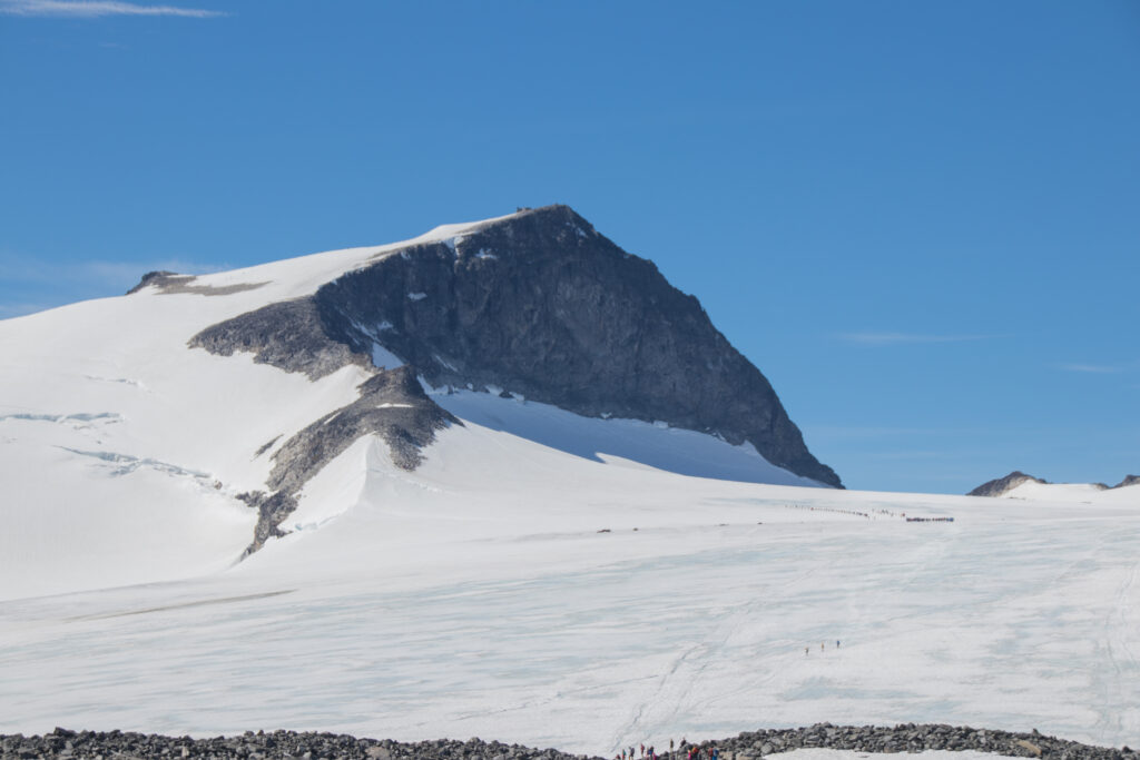
Galdhøpiggen is the highest mountain in Norway and all of Scandinavia.
What makes it unique is that climbers can choose between a classic non-glacier hiking route from Spiterstulen
or a shorter but guided glacier crossing from Juvasshytta. This page covers the main ascent options,
route style, season planning, essential gear, safety notes, featured videos, and guide companies for planning a Galdhøpiggen summit.
Long alpine hiking or guided glacier ascent depending on route
Typical duration
5–9 hours depending on route and conditions
Primary risks
Weather changes, fatigue, slips on rock or snow, glacier hazards on the Juvasshytta route, and route-finding issues
Main Routes (Overview)
Route #1: Spiterstulen Route
Theme: the most common non-glacier route to the summit.
Best for: strong hikers wanting to climb independently in stable conditions.
Character: a long and demanding mountain hike with rocky terrain and big elevation gain.
Typical effort: often around 13 km round trip and usually 7–9 hours.
Route #2: Juvasshytta Route
Theme: the shorter but glacier-based route to the summit.
Best for: climbers who want the classic guided glacier crossing experience.
Character: shorter in distance, but it crosses the crevassed Styggebreen glacier and requires a guide.
Typical effort: about 12 km round trip and commonly 5–7 hours.
Why Galdhøpiggen is so popular
It is the roof of Norway and all of Scandinavia.
It offers a choice between a straightforward hiking ascent and a guided glacier summit experience.
The views over Jotunheimen make it one of the great classic mountain days in Northern Europe.
Access & Logistics
Starting point: Spiterstulen
The classic independent hiking route starts from Spiterstulen.
This is the better choice for hikers who want to avoid glacier travel.
Expect a longer day with more elevation gain and a bigger endurance component.
Starting point: Juvasshytta
Juvasshytta starts much higher and gives a shorter summit day.
The tradeoff is that the route crosses glacier terrain.
For safety reasons, this route is commonly done as a guided rope-team trip.
Best Time to Climb (Season Window)
Season
Typical Conditions
Pros
Watch-outs
Main summer season
Usually mid-summer through early autumn
Best odds for normal route access and guided glacier operations
Cold wind, lingering snow, and quickly changing mountain weather
Shoulder periods
Earlier or later season with more snow and greater uncertainty
Potentially quieter days
Higher route seriousness and more variable conditions
Season planning tip
On Galdhøpiggen, route choice is often more important than the calendar itself.
The Spiterstulen route is the usual hiking option, while Juvasshytta depends on guided glacier travel.
Essential Gear Checklist
Clothing systems
Breathable base layer + insulating mid-layer + weather shell
Warm hat and gloves even in summer
Sunglasses and sun protection
Extra insulation for summit wind and rest stops
Mountain essentials
Sturdy hiking boots or mountain shoes with strong grip
Trekking poles for the long descent
Food, water, emergency layers, and navigation backup
Route-specific glacier gear if joining a guided Juvasshytta crossing
Most underestimated factor
Many hikers underestimate how different the two main routes feel.
Spiterstulen is longer and more physical, while Juvasshytta is shorter but involves real glacier hazards.
Difficulty & Safety Notes
What makes Galdhøpiggen challenging
Distance and elevation: the Spiterstulen route is a big day for most hikers.
Glacier travel: the Juvasshytta route crosses crevassed ice and is guided for good reason.
Weather: even in summer, conditions can become cold, windy, and unpleasant quickly.
Fatigue: long descents and rough terrain can be harder than expected.
Route choice: the easiest route for one person may not be the safest or best route for another.
Disclaimer: Mountain travel has serious objective risk. This page is educational and not a substitute for guide advice, current route conditions, or local mountain judgment.
Featured Videos (Galdhøpiggen)
Global Summit Guide • Video Hub
Galdhøpiggen: Watch & Learn
These videos help visualize the summit terrain, route options, and overall mountain experience.
📜 Disclosure: This page contains affiliate links to Expedia. If you click through and make a booking, Global Summit Guide may earn a small commission at no additional cost to you. Editorial recommendations are independent of commission rates. See our full affiliate disclosure for details.
✈ ⛰ 🏨
Plan Your Adventure
Find Hotels, Flights & Trips for the World’s Best Hiking Destinations
The Global Summit Guide Travel Shop on Expedia — curated for outdoor adventurers, mountaineers, and serious hikers. Patagonia to the Alps. Nepal to the Rockies. Curated lodging for every region we cover.
For many hikers, the Spiterstulen route is the easiest route to do independently because it avoids glacier travel, even though it is longer.
Do I need a guide?
You generally need a guide for the Juvasshytta route because it crosses the crevassed Styggebreen glacier. The Spiterstulen route is commonly done without a guide in good conditions.
Which route is shorter?
The Juvasshytta route is shorter and starts higher, but it trades distance for glacier complexity.
How hard is Galdhøpiggen?
It is a serious mountain day rather than a technical climb for most hikers on Spiterstulen, but weather, fatigue, and route choice can make it much harder than expected.
Related Peaks
Global Summit Guide • Internal Links
More Nordic Objectives
Great additions to your Scandinavia cluster and internal link structure.
Five Notable Galdhøpiggen Climbs and Developments from 2025
A look at five notable Galdhøpiggen climbs and developments from 2025, followed by practical lessons hikers learned about glacier-guided access, long summit days, hut logistics, glacier change, and smart decision-making on Norway’s highest mountain.
Mountain
Galdhøpiggen
Region
Jotunheimen, Norway
Season Focus
2025 Climbs
Overview
Glacier Guiding, Long Routes, and Modern Mountain Change
Galdhøpiggen in 2025 again showed why Norway’s highest summit occupies a special place in Scandinavian mountaineering. It is reachable by strong hikers, families, and guided glacier parties, but the mountain still demands real planning. The two classic routes remained very different experiences, and glacier change stayed part of the wider story around how people understand high mountains in Norway.
Climb / Development 1
The Juvasshytta Glacier Route Stayed the Signature 2025 Guided Galdhøpiggen Experience
Guided Glacier Crossing
Main Base
Juvasshytta
Season Pattern
Daily glacier-guided trips in season
Key Feature
Crossing Styggebreen with a guide
Theme
Galdhøpiggen’s Shortest Famous Route Still Depends on Glacier Management
One of the clearest 2025 realities on Galdhøpiggen was that Juvasshytta remained the classic starting point for guided crossings of Styggebreen to the summit. The hut’s current information says these guided trips ran daily in season from June 1 to September 15. That kept the Juvasshytta line as the mountain’s best-known structured summit experience rather than a casual unguided shortcut.
Climb / Development 2
The Spiterstulen Route Continued to Define the Long 2025 Self-Propelled Summit Day
Endurance Ascent
Main Alternative Route
Spiterstulen approach
Character
Longer, non-glacier summit day
Climber Pattern
Popular with strong hikers avoiding glacier travel
Theme
The Non-Glacier Option Is Still a Big Mountain Day
Another strong 2025 theme was that the Spiterstulen line remained the preferred route for people wanting to reach Galdhøpiggen without a glacier crossing. That route still asks more of the body even if it removes the guide-and-rope element. In practical terms, Galdhøpiggen continued to offer a clear choice between a shorter guided glacier experience and a longer endurance-focused ascent.
Climb / Development 3
Juvasshytta’s 2025 Role Reinforced That Logistics Still Shape Summit Success
Hut Logistics
Hut Season
May to September lodging season
Core Function
Base for summit planning and overnight stays
Family Pattern
Trips designed for a broad range of participants
Theme
A Successful Galdhøpiggen Day Starts Before the Trail
One of the practical 2025 truths around Galdhøpiggen was that Juvasshytta remained more than just a trailhead. Its current information emphasizes lodging, meal service, and trip planning throughout the main season, which reinforces how much summit success depends on staging and timing. On Norway’s highest peak, the day still begins with logistics, not just with walking.
Climb / Development 4
Galdhøpiggen’s Glacier Context Stayed Part of Norway’s Broader 2025 Mountain Story
Category
Details
2025 Glacier Reporting
Southern Norwegian glaciers continued retreating on average
Published
October 2025
Regional Relevance
Jotunheimen glacier environments remain part of this long-term pattern
Theme
Even Classic Summit Routes Now Sit Inside a Changing Ice Landscape
One of the deeper 2025 mountain stories affecting Galdhøpiggen was the continued retreat of southern Norwegian glaciers. Norway’s 2025 glacier reporting said the southern glaciers measured that year retreated on average, reinforcing the wider environmental trend in which summit routes linked to ice and snow are gradually being reshaped. For Galdhøpiggen, that keeps glacier awareness part of the mountain’s future even when climbers focus mainly on the summit itself.
Climb / Development 5
The Strongest 2025 Galdhøpiggen Lesson Was That Route Choice Still Matters More Than Summit Ambition
Judgment Lesson
Guided Pattern
Roped glacier travel from Juvasshytta
Independent Pattern
Longer self-powered ascent from Spiterstulen
Real Decision
Pick the route that matches skill, time, and weather window
Theme
On Norway’s Highest Peak, the Smartest Choice Often Happens Before You Leave the Hut
Galdhøpiggen’s hardest practical lesson in 2025 was not about a single dramatic event. It was about choosing the right kind of summit day. The mountain continued to offer two very different experiences, one centered on a glacier guide and one centered on a long non-glacier ascent, and that meant the safest climbers were still the ones who matched their route to their real skill, fitness, and conditions.
What Climbers Learned on Galdhøpiggen in 2025
These advice notes reflect the most practical lessons that stood out from Galdhøpiggen in 2025.
Galdhøpiggen is accessible, but it still rewards structure
The mountain has a strong hut system and a highly established guided route, but that convenience does not remove the need for planning and timing.
The shortest famous route is still a glacier route
The Juvasshytta experience remained popular in 2025 because the glacier crossing is managed by guides, not because the mountain has somehow become simple.
The non-glacier option demands more endurance than many people expect
The Spiterstulen route still asks for a bigger self-propelled effort even if it removes the technical feel of guided glacier travel.
Glacier change remains part of the mountain’s wider future
Broader 2025 Norwegian glacier reporting reinforced that classic ice-linked mountain environments are still changing around routes like this.
The best Galdhøpiggen decision is often choosing the right route, not just reaching the summit
The strongest practical lesson from 2025 was that success depends on whether a climber chooses the mountain day that fits their experience and conditions.
A successful Galdhøpiggen climb ends only after safe return below the glacier or upper mountain
The strongest overall lesson from 2025 is that on Galdhøpiggen, summit success still depends on planning well enough to get safely all the way back down.
Mountain Map & Weather
Map of Galdhøpiggen
View the summit location, route area, current weather, and 5-day mountain forecast.
Global Summit Guide
Galdhøpiggen Additional Information
Answers to common questions about Galdhøpiggen routes, difficulty, glacier access, timing, safety, and trip planning.
How hard is Galdhøpiggen to climb?
Galdhøpiggen is a demanding mountain hike, but the difficulty depends heavily on the route. The shortest and most popular route from Juvasshytta crosses the Styggebreen glacier and requires a guide, while the route from Spiterstulen is longer and more physically demanding but can be done without a guide in normal conditions. Both options require strong fitness, steady footing, and respect for changing mountain weather.
How much does it cost to climb Galdhøpiggen?
Costs vary depending on your route and whether you go with a guide. Typical expenses may include transportation, accommodation at Juvasshytta or Spiterstulen, meals, parking, and optional guided glacier crossings. The guided Juvasshytta route usually costs more, while the longer Spiterstulen route can be more economical if you go independently.
How long does it take to climb Galdhøpiggen?
The guided route from Juvasshytta is commonly planned as a 5 to 7 hour round trip. The route from Spiterstulen is longer and usually takes most of the day, depending on pace, weather, and route choice. Strong hikers may move faster, but conditions in Jotunheimen can quickly affect timing.
Can a beginner climb Galdhøpiggen?
A fit beginner can sometimes summit Galdhøpiggen, especially on the guided Juvasshytta route in good summer conditions. However, it is still a serious mountain day with altitude, cold, wind, and possible snow. Beginners who are unsure about glacier travel, pacing, or mountain weather often benefit from going with an experienced guide.
Where is Galdhøpiggen located?
Galdhøpiggen is located in Jotunheimen in southern Norway. At 2,469 meters, it is the highest mountain in Norway and the highest mountain in Northern Europe.
Do you need a guide for Galdhøpiggen?
Yes, if you take the shortest route from Juvasshytta, a guide is required because the route crosses the Styggebreen glacier. The route from Spiterstulen can be climbed without a guide in normal summer conditions, but many hikers still choose guided support for safety and route confidence.
Why is Galdhøpiggen considered dangerous?
Galdhøpiggen can be dangerous because of glacier hazards on some routes, cold temperatures, sudden weather changes, wind, snow, and slippery rock. Even on non-glacier routes, the long day and mountain conditions can create serious risks for unprepared hikers.
Global Summit Guide
Expert Resources & Further Reading
Trusted resources for route planning, guided glacier access, and Jotunheimen travel logistics.
Resource
Description
Link
Visit Norway – Hike Norway’s Highest Mountain
Official tourism overview with route context, mountain background, and the note that the Juvasshytta route requires a guide.
Global Summit Guide is an independent mountaineering resource founded in 2026. The team combines first-hand trekking and climbing experience with in-depth research and professional health and nutrition review to help climbers choose objectives, prepare properly, and stay safe.
Travis LudlowFounder & Head of Research · Master's in Business
Dawson LudlowClimbing & Mountaineering Lead
Walker LudlowClimber & Contributor
Health, altitude, and nutrition content is reviewed by Taylor Ludlow (Registered Nurse) and Brigg Hoopes (Nutritionist).
?
What We Don't Know Yet
Mountain information changes quickly. This box explains the limits of what this page can responsibly promise.
Weather, snowpack, avalanche risk, road access, and route conditions can change quickly and may be different on your climbing dates.
Route conditions, trailhead access, crevasse exposure, stream crossings, and rescue access may vary from published planning guidance.
Gear requirements can change by season, route variation, weather window, personal cold tolerance, and guide-service requirements.
Confidence: Medium
Verify current conditions with official land managers, guide services, local forecasts, and current route reports before booking or climbing.
Pillar guide
Part of this Global Summit Guide cluster
Explore the complete Mountains guide for more context, routes, planning links, and related resources.
Safety, medical & liability disclaimer
Mountaineering, rock and ice climbing, glacier travel, and high-altitude activity are inherently dangerous and can result in serious injury or death. The information on Global Summit Guide is provided for general informational and educational purposes only and is not a substitute for professional instruction, qualified guiding, proper equipment, or your own judgment and experience.
Route conditions, weather, snowpack, permits, regulations, and hazards change constantly and may differ from what is described here. Details may be incomplete, out of date, or contain errors. Always verify current information with local authorities, certified guides, and official sources before making any decision in the mountains.
Nothing on this site is medical, legal, or financial advice. Our fitness, acclimatization, altitude, and nutrition content is general in nature; consult a qualified physician before beginning any strenuous exercise program or exposing yourself to high altitude.
You are solely responsible for your own safety and decisions. To the fullest extent permitted by law, Global Summit Guide and its team accept no liability for any loss, injury, damage, or expense arising from use of, or reliance on, this information. By using this site you acknowledge these risks and accept these terms.
Some links on this site may be affiliate links. If you buy through them we may earn a small commission at no extra cost to you; this never affects our recommendations.
Global Summit Guide recommendation path
Next Best Mountain to Research
Use these recommendations to continue the right planning path instead of stopping on one page.