
Last updated September 16, 2026
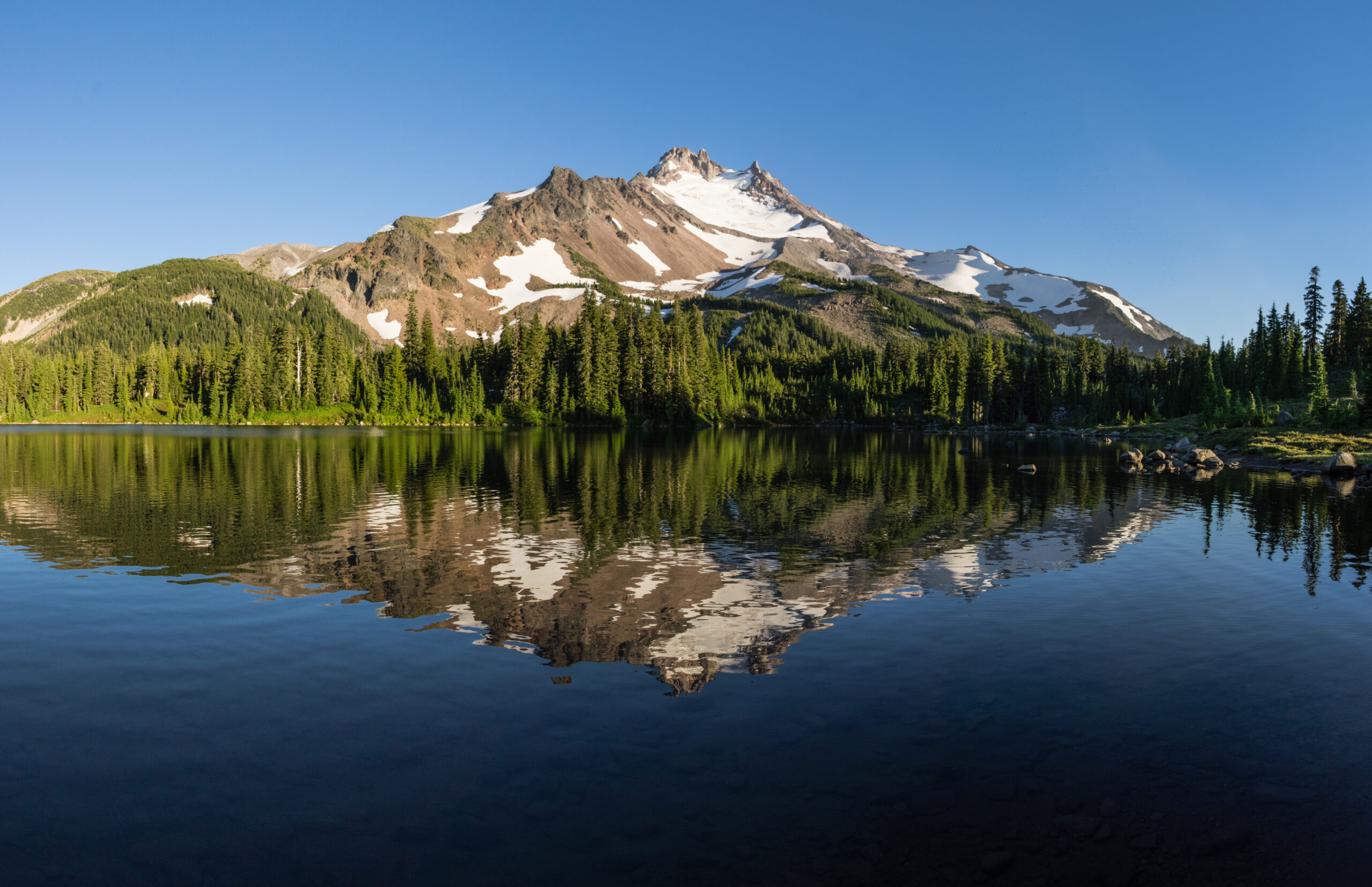
Mount Jefferson Climbing Guide: Whitewater Glacier, Summit Pinnacle & Permits
Mount Jefferson is Oregon’s second-highest mountain and one of the state’s most serious alpine objectives. The classic Whitewater Glacier climb combines a long wilderness approach, glacier travel, loose volcanic terrain and an exposed technical summit finish. The mountain is lower than Mount Hood, but the combination of remoteness, changing glacier conditions and the summit pinnacle makes it a substantially different undertaking.
How hard is Mount Jefferson?
Mount Jefferson should be treated as an advanced Cascade mountaineering objective, not simply a higher version of a hiking volcano.
The Whitewater Glacier route requires the ability to travel competently on a glacier, evaluate crevasse and snow conditions, move through steep loose volcanic terrain, manage significant exposure and deal with the technical upper summit structure.
Current route descriptions from the Mountaineers and Mazamas both emphasize the same pattern: a long approach, real glacier travel and a rock-climbing finish. The Mountaineers call Whitewater a demanding basic alpine/glacier climb; Mazamas notes crevasses, exposed traversing and a technical summit finish.
The result is a mountain whose practical difficulty changes significantly with snow cover, glacier condition, rime ice and the amount of loose rock exposed on the upper mountain.
Roped travel and crevasse-response capability belong in the team’s existing skill set.
Loose volcanic rock, exposure and seasonal rime or ice.
Jefferson does not offer Mount Hood’s road-access convenience.
A summit attempt can reasonably end below the final pinnacle.
Mount Jefferson at a glance
Use these as planning anchors, then verify permits, trailhead status, weather and route conditions immediately before the trip.
| Field | Working answer | Planning implication |
|---|---|---|
| Elevation | 3,199 m / 10,495 ft | Current USGS volcano-page figure. Some historical topo products show 10,497 ft. |
| State ranking | Second-highest mountain in Oregon | Lower than Mount Hood, but elevation is not a useful proxy for technical seriousness. |
| Volcano type | Andesite–dacite stratovolcano | USGS lists the most recent main volcanic activity during the last glaciation, about 15,000 years ago. |
| Classic climbing route | Whitewater Glacier | Glacier, exposed upper terrain and summit rock. |
| Common format | 2–3 days | Three days gives more margin than forcing the approach, summit and exit into a compressed schedule. |
| Land manager | Willamette National Forest / Mount Jefferson Wilderness | Forest Service and Recreation.gov control current access and permit rules. |
| Permit season | June 15–October 15 | Central Cascades Wilderness Permit system applies during these dates. |
| Parking | Federal recreation pass required at Whitewater | The wilderness permit does not replace the trailhead recreation-pass requirement. |
Whitewater Glacier route
The useful route description is the sequence of terrain—not a rigid schedule that conditions can make obsolete.
Whitewater Trailhead → Jefferson Park → glacier → upper shoulder → summit pinnacle
From Whitewater Trailhead, climbers approach through the Mount Jefferson Wilderness toward Jefferson Park and the alpine basin north of the mountain.
From camp or bivouac terrain, the route moves onto the Whitewater Glacier. The precise line is condition-dependent because snow coverage, crevasses, glacier recession and late-season debris change the character of the route.
Above the glacier, the climb reaches increasingly exposed upper terrain beneath the summit structure. The final summit is not a simple snow walk: climbers must negotiate the rocky upper mountain and the summit pinnacle itself.
Reaching the upper mountain is not the same thing as reaching the summit.
Jefferson’s pointed summit structure is why a climber can have a successful alpine day without standing on the highest point. Snow, rime, wind, rockfall, team speed and comfort with exposure can all make turning around below the summit the correct decision.
Mount Jefferson’s summit pinnacle
The exact technical character varies substantially with rime, snow and how much rock is exposed.
Volcanic and loose
Multiple climbing references warn about poor or loose rock on the upper mountain. Team spacing and helmet use matter because one climber can dislodge debris onto another.
Rime changes the climb
Early-season snow or rime can cover rock and change protection and movement. Later-season melt can expose substantially more loose volcanic terrain.
The summit is only halfway
Technical rock and exposed traversing must be reversed after the summit, often when fatigue and afternoon warming have increased.
Skills that should already exist before Jefferson
This is a poor mountain on which to learn multiple technical systems for the first time.
Rope-team travel
Move efficiently on a rope, recognize glacier hazards and understand what your team will do if someone enters a crevasse.
Crampons & axe
Steep snow movement, self-arrest fundamentals and controlled descent should already be familiar.
Exposed alpine movement
Loose rock demands different judgment than solid crag climbing. Holds and blocks must be assessed rather than blindly trusted.
Off-trail competence
The climbing route leaves maintained trail and enters terrain where visibility can change quickly.
Long technical days
Technical competence needs to remain intact after hours of approach, climbing and descent.
Turn around below the summit
A deteriorating pinnacle, increasing rockfall or slow team is enough reason to end the attempt.
Snow coverage matters as much as the calendar
Current climbing references most commonly identify June through August, while some routes remain possible later in suitable years.
| Period | Potential advantage | Main concern |
|---|---|---|
| Late spring | Snow can cover loose volcanic debris and create more continuous climbing surfaces. | Avalanche hazard, access snow and unstable weather. |
| June | Common climbing month in established route references. | Approach snow, snow bridges and changing avalanche conditions. |
| July | Often a useful balance between access and retained snow. | Increasing rockfall and opening crevasses as temperatures rise. |
| August | Usually straightforward road and trail access. | More exposed glacier ice, crevasses and loose rock in dry years. |
| September–October | Some routes can remain climbable in favorable conditions. | Dry glacier, exposed debris, shorter days and early-season storms. |
Mount Jefferson permits
Recreation.gov—not an old climbing guide—is the source to trust for the live permit inventory.
| Use | Current rule | Reservation window | Fee / pass |
|---|---|---|---|
| Overnight climb | Central Cascades Wilderness Overnight Permit required for all overnight use in Mount Jefferson Wilderness June 15–October 15. | About 40% of quota opens the first Tuesday in April; remaining ~60% releases 7 days before trip start. | $6 reservation fee per permit. |
| Day climb from Whitewater | Whitewater is one of the limited-entry trailheads requiring a Central Cascades day-use permit June 15–October 15. | Permits release in 10-day and 2-day rolling windows. | Verify current day-use reservation charge at booking. |
| Trailhead parking | A federal recreation pass is required at Whitewater Trailhead. | Separate from wilderness permit. | Northwest Forest Pass or qualifying federal interagency pass. |
Official overnight reservations: Central Cascades Wilderness Overnight Permits .
Official day-use system: Central Cascades Wilderness Day Use .
Whitewater is an active trailhead—but burned-area travel remains part of the plan
The Mount Jefferson landscape has been repeatedly affected by wildfire, and closure boundaries can change independently of the climbing season.
Whitewater
Recreation.gov currently maintains Whitewater as a permit-controlled Mount Jefferson trailhead, and the Forest Service destination system lists it as an active recreation site.
Expect changing hazards
Fire-damaged landscapes can contain falling trees, damaged tread, debris movement and reduced shade long after the fire itself is out.
Check alerts again
A permit reservation does not guarantee that every trail, road or route is open when your date arrives.
Why Mount Jefferson deserves conservative decisions
The risk comes from several terrain types stacked together, not one spectacular crux.
Crevasses
Whitewater is a real glacier. Snow bridges and open cracks change through the season.
Rockfall
Volcanic debris and summit rock can become increasingly active as the mountain warms and dries.
Avalanche conditions
Earlier-season climbing can improve snow coverage while introducing a different hazard profile.
Upper traverses
Falling on some upper-mountain terrain can have serious consequences even when the technical moves are modest.
Wind, cloud & storms
Poor visibility or precipitation can make glacier navigation and the summit pinnacle much more serious.
Technical descent
The same exposed and loose terrain still has to be reversed after the summit attempt.
Whitewater is not the only way up Mount Jefferson
Route choice becomes more specialized as climbers move away from the classic Whitewater system.
| Route / system | Character | Planning note |
|---|---|---|
| Whitewater Glacier | Classic glacier approach with technical summit finish. | Best documented choice for climbers researching a first Jefferson attempt. |
| Jefferson Park Glacier | More technical glacier / mixed climbing depending on conditions. | Timberline Mountain Guides currently lists this as an advanced alpine climb. |
| South Ridge | Summer mixed / rock-oriented approach from the south. | Uses different access and permit logistics from Whitewater. |
| West Rib | Steep snow and mixed alpine objective. | Route-specific seasonal timing matters strongly. |
| East Face | Steeper snow line above the Whitewater Glacier. | Mazamas specifically warns about severe rockfall when significant rock is exposed. |
The permit is cheap. The required experience is not.
This is not a mountain where a generic old guide-price range adds much value.
Low official access cost
The current overnight reservation fee is only $6 per permit, plus the required recreation pass at the trailhead.
Travel, fuel, food and personal climbing equipment are then the primary trip expenses.
Request a current route-specific quote
Timberline Mountain Guides currently lists Mount Jefferson objectives, including Jefferson Park Glacier, South Ridge and West Rib.
Rather than publishing an old $700–$1,800 generic range, contact the guide service for current dates, route, ratio and price.
Current guide-service reference: Timberline Mountain Guides — Mount Jefferson .
What should come before Mount Jefferson?
The goal is not to collect specific summit names. It is to arrive with every major Jefferson skill already familiar.
Become efficient with crampons, ice axe, alpine starts, cold-weather layering and long snow descents.
Add roped glacier travel and crevasse-response skills on a mountain with a less complex summit finish.
Build confidence on loose or exposed scrambling where a rope may become part of the team system.
Combine glacier travel, technical upper terrain and a long descent while maintaining decision quality under fatigue.
Attempt the mountain when the route systems are familiar enough that conditions—not basic skill acquisition—become the main decision problem.
The mountain itself is changing
Glacier retreat has practical implications for approaches, debris and route conditions.
A dormant Cascade stratovolcano
The current USGS Mount Jefferson page describes an andesite–dacite volcano built in several stages over hundreds of thousands of years, with the youngest main-cone activity during the last glaciation.
Shrinking glaciers expose unstable debris
Forest Service research identifies retreating glaciers and unconsolidated sediment around Mount Jefferson as contributors to rockfall, landslide and debris-flow vulnerability.
Mount Jefferson climbing questions
Route descriptions are planning context, not substitutes for current field conditions.
How high is Mount Jefferson?
The current USGS volcano page lists Mount Jefferson at 3,199 m / 10,495 ft. Historical USGS/Forest Service topographic products have also shown a 10,497-foot summit figure.
Is Mount Jefferson harder than Mount Hood?
Jefferson is generally a more remote and complex climbing undertaking: longer access, more wilderness logistics, glacier travel and a technical summit finish. “Harder” still depends on route and conditions, so this page does not treat that comparison as a formal universal grade.
What is the main Mount Jefferson route?
Whitewater Glacier is one of the classic and most widely documented routes. It approaches through Jefferson Park, crosses glacier terrain and finishes through technical upper-mountain terrain.
Do I need a permit?
Yes during the Central Cascades permit season. All overnight visits to Mount Jefferson Wilderness require a Central Cascades Wilderness Overnight Permit from June 15 through October 15, and Whitewater also requires a day-use permit during that period.
How much is the overnight permit?
Recreation.gov currently charges a $6 reservation fee per Central Cascades Wilderness Overnight Permit. A separate federal recreation pass is required at Whitewater Trailhead.
When should I climb Mount Jefferson?
June through August is the most commonly referenced season for Whitewater Glacier, although some routes remain climbable later in suitable years. Snow coverage, glacier condition, rockfall, rime, wildfire restrictions and weather matter more than a calendar rule.
How many days should I allow?
Two to three days is a common structure. A third day can provide more flexibility for approach, summit timing and exit than forcing the entire climb into a compressed weekend.
Can I hire a guide?
Yes. Timberline Mountain Guides currently lists several Mount Jefferson objectives. Ask for the current route, prerequisites, guide ratio, included equipment and price rather than relying on old generic guide-cost estimates.
Use each source for what it actually knows
Land managers own access rules. USGS owns volcano data. Climbing organizations and guide services provide route context.
Mount Jefferson Volcano
Current elevation, location, volcano type, composition and eruption-history context.
Open USGS →Central Cascades Overnight Permits
Permit season, reservation fee, April quota release and seven-day rolling inventory.
Open overnight permits →Whitewater Day-Use Permit
Whitewater day-use requirement, 10-day / 2-day release windows and recreation-pass requirement.
Open Whitewater permit →Whitewater Glacier Route
Approach, glacier route structure, equipment category, seasonal context and Mount Jefferson difficulty.
Open route reference →Mount Jefferson — Whitewater Glacier
Independent Oregon climbing-club description of glacier terrain, exposure, summit rock and required skills.
Open Mazamas route →Mount Jefferson Programs
Current commercial Jefferson route offerings and prerequisite framing.
Open guide-service page →Build the Mount Jefferson progression
Jefferson makes the most sense after snow climbing, glacier systems and exposed alpine movement are already established skills.
Was this helpful?
🏔Related peaks nearby
🧭Explore & compare
Global Summit Guide is an independent mountaineering resource founded in 2026. The team combines first-hand trekking and climbing experience with in-depth research and professional health and nutrition review to help climbers choose objectives, prepare properly, and stay safe.
Health, altitude, and nutrition content is reviewed by Taylor Ludlow (Registered Nurse) and Brigg Hoopes (Nutritionist).
What We Don't Know Yet
Mountain information changes quickly. This box explains the limits of what this page can responsibly promise.
- Permit availability, reservation windows, quotas, and official fee rules may change after this page is updated.
- Route conditions, trailhead access, crevasse exposure, stream crossings, and rescue access may vary from published planning guidance.
- Visa, passport, vaccination, border, insurance, and local transportation rules may change before your trip.
Verify current conditions with official land managers, guide services, local forecasts, and current route reports before booking or climbing.
Mountaineering, rock and ice climbing, glacier travel, and high-altitude activity are inherently dangerous and can result in serious injury or death. The information on Global Summit Guide is provided for general informational and educational purposes only and is not a substitute for professional instruction, qualified guiding, proper equipment, or your own judgment and experience.
Route conditions, weather, snowpack, permits, regulations, and hazards change constantly and may differ from what is described here. Details may be incomplete, out of date, or contain errors. Always verify current information with local authorities, certified guides, and official sources before making any decision in the mountains.
Nothing on this site is medical, legal, or financial advice. Our fitness, acclimatization, altitude, and nutrition content is general in nature; consult a qualified physician before beginning any strenuous exercise program or exposing yourself to high altitude.
You are solely responsible for your own safety and decisions. To the fullest extent permitted by law, Global Summit Guide and its team accept no liability for any loss, injury, damage, or expense arising from use of, or reliance on, this information. By using this site you acknowledge these risks and accept these terms.
Some links on this site may be affiliate links. If you buy through them we may earn a small commission at no extra cost to you; this never affects our recommendations.
Global Summit Guide recommendation path
Next Best Mountain to Research
Use these recommendations to continue the right planning path instead of stopping on one page.
Use current permit, weather, route, and operator information before booking or climbing.
Search Flights, Hotels & Rental Cars
Have the mountain or destination picked? Use Expedia to compare the flights, lodging and rental cars that fit your actual trip dates. For mountain travel, consider arriving early enough for delays and adding a buffer night after the climb before a fixed flight home.
Compare current flight, hotel and car options.
Affiliate disclosure: Global Summit Guide may earn a commission if you book through this link, at no additional cost to you.