
Last updated September 23, 2026
La Meije Climb Guide: Promontoire Route, Difficulty & Classic Traverse
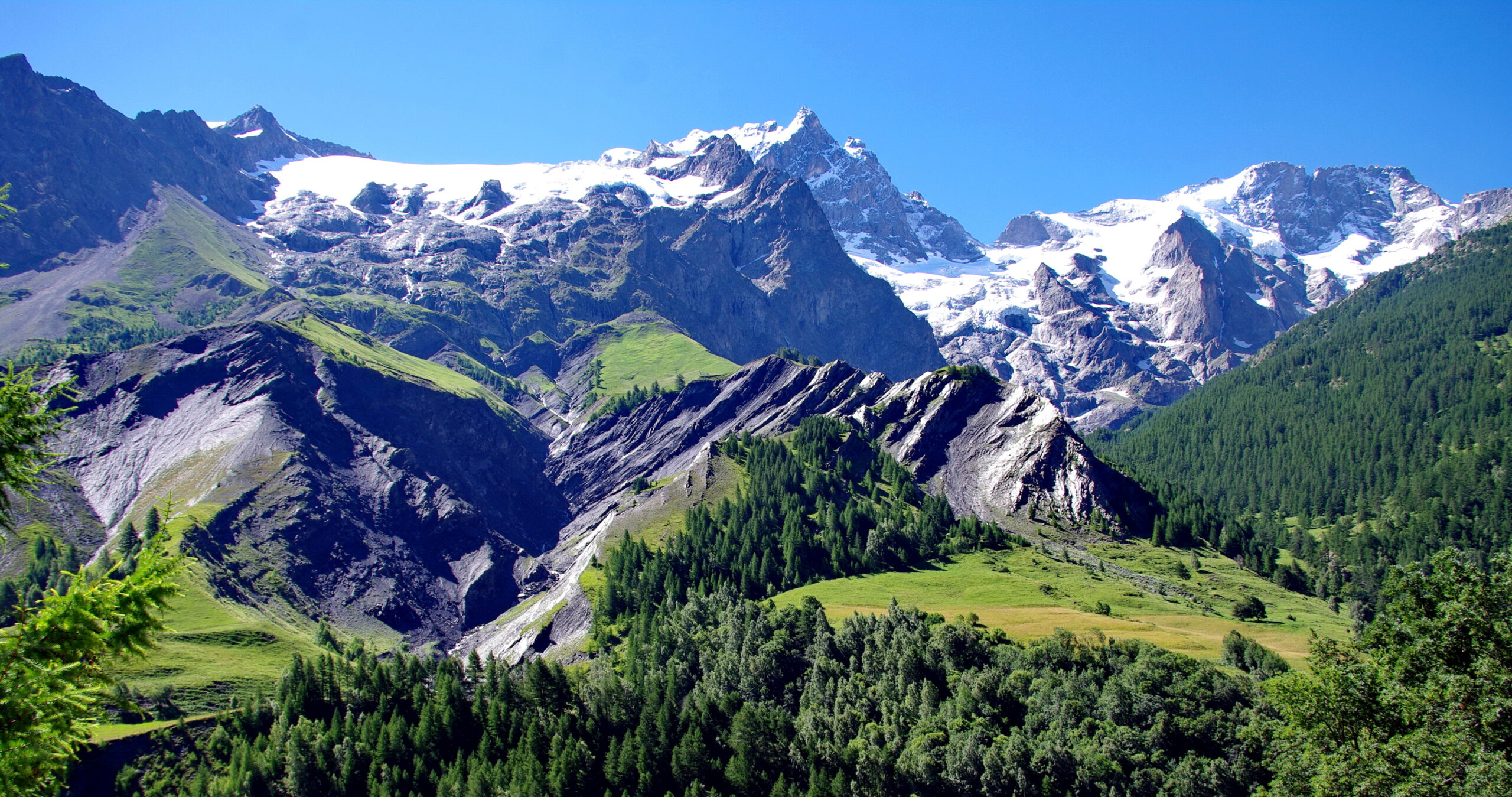
La Meije rises to 3,983 metres above La Grave and the Écrins. Unlike many famous Alpine summits, the Grand Pic has no easy route: even its historic normal line demands exposed rock climbing, glacier travel, crampon skill, efficient ropework and confident movement in serious mountain terrain.
How Hard Is La Meije?
La Meije is an advanced technical Alpine climb, not a beginner 4,000-metre-style objective. The historic route climbs from Refuge du Promontoire to the 3,983 m Grand Pic over sustained exposed rock and the Glacier Carré. The complete classic traverse continues across the summit ridge toward the Doigt de Dieu and Refuge de l’Aigle. The Bureau des Guides de La Grave classifies the traverse as advanced and expects regular mountaineering experience, efficient rope management, crampon skill, strong endurance and comfort climbing in mountain boots.
One of the Alps’ Most Complete Classic Mountaineering Objectives
La Meije is not defined by a single crux. Its seriousness comes from combining exposed rock, mixed terrain, glacier travel, route-finding, altitude, rappels and a long summit day into one continuous mountain problem.
La Meije Routes & Summit Options Compared
“Climbing La Meije” can mean reaching the Grand Pic, completing the full west-to-east traverse or using the Aigle side for a separate eastern summit. They are not equivalent objectives.
| Objective | Primary hut | Terrain | Commitment | Best fit |
|---|---|---|---|---|
| Grand Pic via Promontoire | Refuge du Promontoire | Exposed alpine rock, Glacier Carré, upper ridge | High | Experienced alpine climbers focused on the true summit |
| Classic La Meije Traverse | Promontoire → Aigle | Grand Pic ascent plus ridge climbing, down-climbing, cables and rappels | Very high | Advanced climbers wanting the complete historic objective |
| Meije Orientale | Refuge de l’Aigle | Glacier, snow and alpine ridge terrain | Moderate to high | Climbers building experience around the Meije massif |
Route difficulty changes with snow cover, verglas, glacier condition, rockfall, temperature and the team’s speed. A historic route name does not imply fixed conditions.

Why La Meije Is Harder Than Its Elevation Suggests
At 3,983 metres, La Meije is lower than the Alps’ famous 4,000ers. That number tells you very little about the technical demands of the Grand Pic and traverse.
Mountain-Boot Climbing Matters
The La Grave guide bureau specifically expects climbers to be experienced on roughly IV+ rock in mountain boots before considering the traverse.
Requirement: efficiency, not just maximum gradeThe Terrain Stays Serious
Large sections of the route are exposed. Hesitation, slow belays and poor rope management accumulate into meaningful time losses high on the mountain.
Requirement: calm movement above consequential terrainRock, Snow & Glacier in One Day
Parties must change smoothly between rock climbing, crampon terrain, glacier travel, down-climbing and rappelling.
Requirement: fast, practiced transitionsThe Line Is Part of the Difficulty
Local guides emphasize sense of itinerary as a core La Meije skill. Losing time on moderate ground can become more important than one hard move.
Requirement: alpine route judgmentPrecision Late in the Day
The summit and traverse occur after hours of climbing. Fitness needs to preserve decision-making and movement quality rather than merely get you uphill.
Requirement: long-day durabilityThe Summit Is Not the Finish
On the full traverse, reaching the Grand Pic opens another major technical section. The ridge, descent and return logistics still remain.
Requirement: manage the whole dayIf exposed rock climbing, crampons, glacier travel, rappelling and rope systems are still new skills, build them on less committing routes before treating La Meije as the objective.
La Meije Map: La Grave, Grand Pic & the Two Key Huts
La Grave lies immediately north of the massif. Refuge du Promontoire occupies the south side beneath the historic route, while Refuge de l’Aigle sits high on the northeast side.
The Climb Crosses the Mountain
The classic traverse links different sides of the massif rather than simply returning down one hiking trail.
Map for regional orientation only. It is not a climbing topo or navigation tool.

The Normal Route Is Still a Technical Alpine Route
On La Meije, “normal route” means the historically standard way to reach the Grand Pic. It does not mean easy. Climbers still need exposed rock ability, crampon competence, route-finding and efficient rope systems.
Climbing the Grand Pic via the Promontoire
The route begins almost at the hut door and links a sequence of famous rock passages with the Glacier Carré and exposed upper ridge.
Refuge du Promontoire → Castelnau Wall
Unlike a hut approach that begins with a long trail, the climbing starts immediately. The lower Promontoire route is normally climbed in darkness before dawn, making route familiarity and rope efficiency valuable from the first pitches.
Historic passages include the Castelnau wall, Dalle des Autrichiens and Pas du Chat. Their significance is not merely historical: together they create the sustained rock character that separates La Meije from easier snow-and-glacier summits.

Glacier Carré → West Ridge
The Glacier Carré forces a full terrain transition high on the route. Snow firmness, ice exposure, bergschrund condition and temperature can materially change how quickly this portion goes.
This is why La Meije rewards climbers whose crampon system is already automatic. The goal is not simply to own the equipment—it is to move between systems without losing large amounts of time.
Cheval Rouge → Grand Pic
The upper mountain becomes increasingly exposed around the Cheval Rouge before easing toward the final ridge and Grand Pic.
For climbers completing only the Grand Pic, the summit is followed by a technical reversal of the route. For parties attempting the classic traverse, it becomes the beginning of an entirely new section of the climb.
The Classic La Meije Traverse
The full west-to-east traverse is what turns a Grand Pic ascent into one of the Alps’ landmark ridge journeys.
A Second Climb Begins at the Summit
From the Grand Pic, the route descends and rappels toward the Brèche Zsigmondy before continuing through the summit ridge.
The local guide bureau describes cables around the first Dent, a long and physical high-altitude section, continuation to the Doigt de Dieu and descent onto the Glacier du Tabuchet before Refuge de l’Aigle comes into view.
- Repeated climbing and down-climbing.
- Multiple rope-management decisions.
- Rappels where speed and organization matter.
- Exposure continuing long after the Grand Pic.
- Glacier terrain at the eastern end.
- A long descent still waiting beyond Refuge de l’Aigle.

Current La Meije Access Has Changed
Older guidebooks and trip reports can describe an approach that is not currently available. Access deserves the same pre-trip verification as weather and hut status.
FFCAM currently states that the road to La Bérarde remains closed for an indefinite period following the severe June 21, 2024 weather event. Current access to Refuge du Promontoire is via Les Enfetchores and the Brèche de la Meije using the La Grave cable car. FFCAM explicitly describes this as a mountaineering itinerary requiring appropriate equipment and knowledge.
Base in La Grave
La Grave gives direct access to the cable-car side of La Meije, the local guide bureau and the best place to confirm current mountain information.
Verify the Lift
Check current operating dates and first-lift timing rather than assuming the cable-car schedule from a previous season.
Confirm Promontoire Access
The Enfetchores and Brèche de la Meije approach is itself technical alpine terrain. Conditions on this approach can affect the entire itinerary.

When to Climb La Meije
The correct question is not simply “July or August?” La Meije needs a combination of dry rock, workable glacier conditions, stable weather, open huts, lift access and enough daylight for the objective.
Transition Season
Summer hut staffing begins around early June, but lingering snow can leave substantially more mixed terrain on the approach and rock sections.
Strong Traverse Window
The La Grave guide bureau notes that in recent seasons the ideal traverse period has often fallen from roughly mid-June through late July.
Condition Dependent
Rock may be dry, but prolonged summer heat can change glaciers, bergschrunds and rockfall exposure. Verify current conditions instead of assuming August is automatically better.
Narrower Margin
Huts approach the end of summer staffing, daylight shortens and an early cold storm can rapidly return snow or verglas to technical rock.
The local guide bureau explicitly describes its recent mid-June-to-late-July preference as a pattern, not an absolute rule. Use current hut, guide and weather information before selecting the actual summit window.
Huts, Itinerary, Gear & Readiness
A successful La Meije plan connects technical ability to current access and then leaves enough margin for a route where delays compound quickly.
La Grave → Promontoire
The current guided approach uses the first section of the La Grave cable car, then Les Enfetchores, the Meije Glacier and Brèche de la Meije before reaching Refuge du Promontoire.
Guide-bureau baseline: about 1,300 m of vertical and roughly 4–5 hours.
Grand Pic → Traverse
Climb directly from Promontoire through the historic route to the Grand Pic, then continue across the summit ridge toward the Doigt de Dieu and Refuge de l’Aigle.
Guide-bureau baseline: roughly 7–10 hours to Refuge de l’Aigle.
Aigle → Romanche Valley
Reaching Refuge de l’Aigle does not end the trip. The guide bureau describes roughly another three hours of descent toward La Grave after the traverse.
Promontoire & Refuge de l’Aigle
Refuge du Promontoire — 3,092 m: the key hut beneath the south side of La Meije. FFCAM lists normal summer staffing from early June through the first weekend of September.
Refuge de l’Aigle — 3,440 m: perched above the Romanche valley close to La Meije’s north side. FFCAM lists normal summer staffing from early June to early September.
Both huts retain winter-room functions outside staffed periods, but an unstaffed refuge should never be treated as normal summer service. Confirm water, bedding, reservation and access details directly.

What Gear Does La Meije Require?
This is a mixed alpine climb. Equipment should be chosen for the exact route, current conditions, rope team and professional guidance—not copied blindly from a static checklist.
Rock & Rope
- Climbing helmet
- Mountaineering harness
- Belay / rappel system
- Locking carabiners and slings
- Route-appropriate protection
Crampons & Axe
- Crampon-compatible mountain boots
- Properly fitted crampons
- Classic mountaineering ice axe
- Glacier-rescue equipment
- Practiced crevasse-rescue skills
Weather & Hut Gear
- Weatherproof shell
- Insulation appropriate to forecast
- Warm gloves plus backup
- Headlamp and spare power
- Hut sleeping-bag liner
- Food and hydration plan
The La Grave guide bureau specifically lists helmet, harness, crampon-compatible mountain boots, ice axe, fitted crampons and approximately a 35 L backpack among client equipment for the traverse.
Are You Ready to Climb La Meije?
Fitness matters, but technical efficiency is usually the bigger filter. A strong hiker is not automatically prepared for this mountain.
Can You Move Efficiently on Exposed Alpine Rock?
Local guide guidance points toward previous IV+ climbing experience in mountain boots rather than indoor climbing ability alone.
Are Snow Transitions Automatic?
You should already be able to put on crampons, move securely and transition back to rock without turning each change into a major delay.
Does the Team Share One System?
Belays, short-roping decisions, rappels and protection become much slower when partners have incompatible habits.
Can You Keep Moving Above Serious Terrain?
Psychological comfort is a performance factor here. Extended hesitation is not simply inconvenient—it consumes weather and daylight margin.
Can You Stay Precise for a Long Day?
The guide bureau expects very good physical condition and comfort with one or more long endurance days carrying a roughly 10 kg pack.
Would a Local Guide Improve the Margin?
If route-finding or system efficiency is the uncertainty, local knowledge can materially change how the climb is managed.

The Last Major Alpine Summit to Be Climbed
La Meije holds an unusual place in Alpine history because the mountain resisted the first-ascent era longer than the other great Alpine summits.
On August 16, 1877, Emmanuel Boileau de Castelnau reached the Grand Pic with the local guides Pierre Gaspard and Pierre Gaspard fils. Their line climbed from the south through the Promontoire and Glacier Carré—the foundation of the classic route still used today.
The summit ridge then became the next great problem. By the late nineteenth century, climbers had connected the Grand Pic with the eastern summits, creating the west-to-east journey that developed into today’s celebrated classic traverse.
Check the Sources That Can Still Change
Evergreen route information is useful for planning. Current access, hut status, weather and local route conditions should always come from live sources close to the trip.
La Meije Climbing FAQ
These are the questions that matter before moving from mountain research into an actual La Meije plan.
How difficult is La Meije?
La Meije is an advanced Alpine climb. It combines sustained exposed rock, glacier terrain, crampons, route-finding, rope management and rappels. Its technical complexity matters more than the fact that the Grand Pic is just below 4,000 metres.
What is the normal route on La Meije?
The historic normal route to the Grand Pic climbs from Refuge du Promontoire through the Promontoire ridge, classic rock passages, the Glacier Carré and the exposed upper ridge to the 3,983 m summit.
What is the classic La Meije traverse?
The complete traverse climbs the Grand Pic from Promontoire, continues east over the summit ridge through climbing and rappelling terrain toward the Doigt de Dieu, then descends to the Glacier du Tabuchet and Refuge de l’Aigle.
Can beginners climb La Meije?
No. La Meije is not an appropriate first mountaineering objective. Climbers should arrive with established rock, crampon, glacier, rope and long-day alpine experience.
What is the best time to climb La Meije?
The broad summer season runs from June into early September. The La Grave guide bureau notes that recent ideal traverse windows have often fallen between mid-June and late July, but emphasizes that this is not an absolute rule. Current conditions should decide the final timing.
How long does the La Meije traverse take?
Local guided programs normally use two or three days. The current La Grave itinerary describes roughly 4–5 hours and 1,300 m of vertical to Refuge du Promontoire on the approach day, then approximately 7–10 hours to Refuge de l’Aigle during the main traverse, followed by a further descent toward La Grave.
Where should I stay before climbing La Meije?
La Grave is the practical valley base for the current northern approach and local guide information. On the mountain, Refuge du Promontoire is the key hut before the Grand Pic and Refuge de l’Aigle serves the eastern side of the traverse.
Can I currently approach Refuge du Promontoire from La Bérarde?
Do not plan around the historical La Bérarde road approach without checking. FFCAM currently states that the La Bérarde road remains closed indefinitely and identifies Les Enfetchores and Brèche de la Meije via the La Grave cable car as the current Promontoire access.
Is La Meije harder than Mont Blanc?
The climbs test different things. La Meije is lower but substantially more technical than the standard Mont Blanc routes, with sustained exposed rock, complex ropework and a demanding traverse. Elevation alone is therefore a poor way to compare them.
Put La Meije Into the Larger Alpine System
Use these pages to move from one mountain into the broader Alps, European mountain selection, route decisions and current mountain-planning skills.
Explore All Mountains
Return to the main Global Summit Guide mountain architecture and browse the complete 500-peak system.
Cluster 1 · AlpsAlps Classics
Compare the major iconic peaks that shaped European mountaineering.
Cluster 2 · EuropeBest Mountains in Europe
Compare European mountains by technical level, season, trip style and overall objective.
Cluster 3 · French AlpsBest Hikes in the French Alps
Explore the trekking side of the same region, from Chamonix to the Écrins.
Cluster 4 · RoutesMountain Route Comparisons
Compare how route choice changes difficulty, objective hazards, logistics and required experience.
Cluster 5 · WeatherMountain Weather for Climbers
Build a better framework for wind, freezing level, storms, timing and usable summit windows.
Deep recovery 1Mont Blanc via the Goûter Route
Contrast La Meije’s technical rock character with the logistics and objective hazards of the Alps’ highest summit.
Deep recovery 2What to Climb Before the Matterhorn
Use another major Alpine objective to think about progression, exposed climbing and prerequisite experience.
Deep recovery 3Mont Blanc Difficulty & Safety
Compare how altitude, terrain, weather and objective hazards create a very different Alpine risk profile.
Arrive With the Skills. Then Choose the Window.
La Meije rewards climbers who already know how to move efficiently on exposed rock, glaciers and mixed Alpine terrain. Build those systems first, verify the current Promontoire access and route conditions, then treat the weather window—not the calendar—as the final decision.
Was this helpful?
🏔Related peaks nearby
🧭Explore & compare
Global Summit Guide is an independent mountaineering resource founded in 2026. The team combines first-hand trekking and climbing experience with in-depth research and professional health and nutrition review to help climbers choose objectives, prepare properly, and stay safe.
Health, altitude, and nutrition content is reviewed by Taylor Ludlow (Registered Nurse) and Brigg Hoopes (Nutritionist).
What We Don't Know Yet
Mountain information changes quickly. This box explains the limits of what this page can responsibly promise.
- Route conditions, trailhead access, crevasse exposure, stream crossings, and rescue access may vary from published planning guidance.
- Visa, passport, vaccination, border, insurance, and local transportation rules may change before your trip.
- Route conditions, snowpack, closures, and weather can change quickly after this page is updated.
- Permit rules, fees, quotas, and reservation windows may change between review cycles.
- Operator availability, pricing, guide ratios, and cancellation terms can change by season.
Verify current conditions with official land managers, guide services, local forecasts, and current route reports before booking or climbing.
Mountaineering, rock and ice climbing, glacier travel, and high-altitude activity are inherently dangerous and can result in serious injury or death. The information on Global Summit Guide is provided for general informational and educational purposes only and is not a substitute for professional instruction, qualified guiding, proper equipment, or your own judgment and experience.
Route conditions, weather, snowpack, permits, regulations, and hazards change constantly and may differ from what is described here. Details may be incomplete, out of date, or contain errors. Always verify current information with local authorities, certified guides, and official sources before making any decision in the mountains.
Nothing on this site is medical, legal, or financial advice. Our fitness, acclimatization, altitude, and nutrition content is general in nature; consult a qualified physician before beginning any strenuous exercise program or exposing yourself to high altitude.
You are solely responsible for your own safety and decisions. To the fullest extent permitted by law, Global Summit Guide and its team accept no liability for any loss, injury, damage, or expense arising from use of, or reliance on, this information. By using this site you acknowledge these risks and accept these terms.
Some links on this site may be affiliate links. If you buy through them we may earn a small commission at no extra cost to you; this never affects our recommendations.
Global Summit Guide recommendation path
Next Best Mountain to Research
Use these recommendations to continue the right planning path instead of stopping on one page.
Use current permit, weather, route, and operator information before booking or climbing.