
Last updated September 9, 2026

Best Hikes on New Zealand’s North Island: 12 Trails from Tongariro to Cape Brett
The North Island is a volcanic hiking destination first, but not only. Tongariro supplies the best alpine day and multi-day circuit; Taranaki adds a standalone maunga and the Pouākai landscape; Lake Waikaremoana adds a remote Great Walk; Coromandel and Northland trade snow risk for forest, huts and coast.
Choose Tongariro for volcanoes, Taranaki for the mountain, and Waikaremoana for remoteness.
Tongariro Alpine Crossing is the best overall day hike on the North Island: one concentrated day of crater rims, lava, alpine exposure and volcanic lakes. Tongariro Northern Circuit is stronger when you have three or four days and want the landscape to become a journey rather than a crossing.
Pouākai Circuit is the best Taranaki trip for most hikers; it gives mountain views without making the summit the only measure of success. Lake Waikaremoana is the best remote Great Walk. The Pinnacles is the cleanest classic hut overnight to fit into a road trip, while Cape Brett is the best coastal overnight.
North Island hikes are not interchangeable
A Great Walk booking, a shuttle-based alpine crossing and a steep mountain summit can all appear on the same road trip, but they require very different decisions. Start with the experience, then solve the booking and transport.
| Hike | Region | Time | Difficulty | Best for | Main issue |
|---|---|---|---|---|---|
| Tongariro Alpine Crossing | Tongariro | 7–8 hr | Hard | Volcanic day | Weather + shuttle |
| Northern Circuit | Tongariro | 3–4 days | Hard | Volcanic backpack | Bookings + 2026 reopening |
| Pouākai Circuit | Taranaki | 2–3 days | Hard | Taranaki scenery | Weather + hut |
| Lake Waikaremoana | Te Urewera | 4 days | Moderate–hard | Remote Great Walk | Bookings + one-way transport |
| Pinnacles | Coromandel | Day / overnight | Moderate–hard | Hut trip | Hut booking |
| Cape Brett | Northland | Full day / overnight | Hard | Coastal ridge | Walkway fee + hut |
| Taranaki summit | Taranaki | Full day | Very hard | Serious summit | Season + snow/ice |
| Tama Lakes | Tongariro | 5–6 hr | Moderate–hard | Crossing alternative | Wind + exposure |
| Taranaki Falls | Tongariro | ~2 hr | Easy–moderate | Short volcanic loop | Weather |
| Rangitoto Summit | Auckland | ~2 hr | Moderate | City add-on | Ferry timing |
| Te Whara | Northland | 5–6 hr | Hard | Coastal ridge day | Point-to-point transport |
| Tarawera Trail | Rotorua | 5–6 hr | Moderate | Forest + lake | Return transport |
The best hikes on New Zealand’s North Island
The order favors overall trip value, landscape distinctiveness and how well each route represents its region. Difficulty is not the ranking system: the seventh hike is much harder than several above it.
Tongariro Alpine Crossing
A long volcanic crossing past Red Crater and the Emerald Lakes. It is the North Island’s strongest single-day mountain walk, but weather, winter snow and point-to-point transport make preparation part of the hike.
Tongariro Northern Circuit
A multi-day journey through the volcanic heartland. The 2026/27 season is unusual because fire repairs and the new Oturere Hut affect the opening schedule.
Pouākai Circuit
Forest, alpine tussock, wetland and the famous tarn views of Taranaki Maunga. It gives hikers a full mountain experience without turning the trip into a summit climb.
Lake Waikaremoana Track
A one-way Great Walk through the homeland of Ngāi Tūhoe, with rainforest, lake shore, Panekire views and a transport puzzle that should be solved before the first walking day.
Kauaeranga Kauri Trail / Pinnacles
A steep historic route into the Coromandel interior. Stay at the 80-bunk Pinnacles Hut or complete the lookout as a long day from the road end.
Cape Brett Track
Rugged ridge walking above the Bay of Islands, with steep drop-offs, private-land access on the first 10 km and a hut at the cape.
Taranaki Maunga Summit Climb
A steep 1.6 km vertical climb for fit, experienced hikers in the summer window. Snow, ice and crater ice can turn it into mountaineering terrain.
Tama Lakes Track
A strong volcanic-landscape alternative when the full Alpine Crossing is too exposed or transport does not work. The upper lake viewpoint is still an exposed mountain objective.
Taranaki Falls Track
A compact loop from Whakapapa through lava-flow scenery, tussock and forest to Taranaki Falls. It works especially well on a travel day or as a bad-weather fallback.
Rangitoto Summit Track
A ferry-access volcanic walk with lava fields, pōhutukawa forest and a summit view over Auckland and the Hauraki Gulf.
Te Whara Track
A steep coastal ridge through Bream Head Scenic Reserve with broad ocean views and a more rugged feel than its modest elevation suggests.
Tarawera Trail
A forest-and-lake walk to Hot Water Beach on Lake Tarawera, useful for travelers who want a substantial day without alpine exposure.
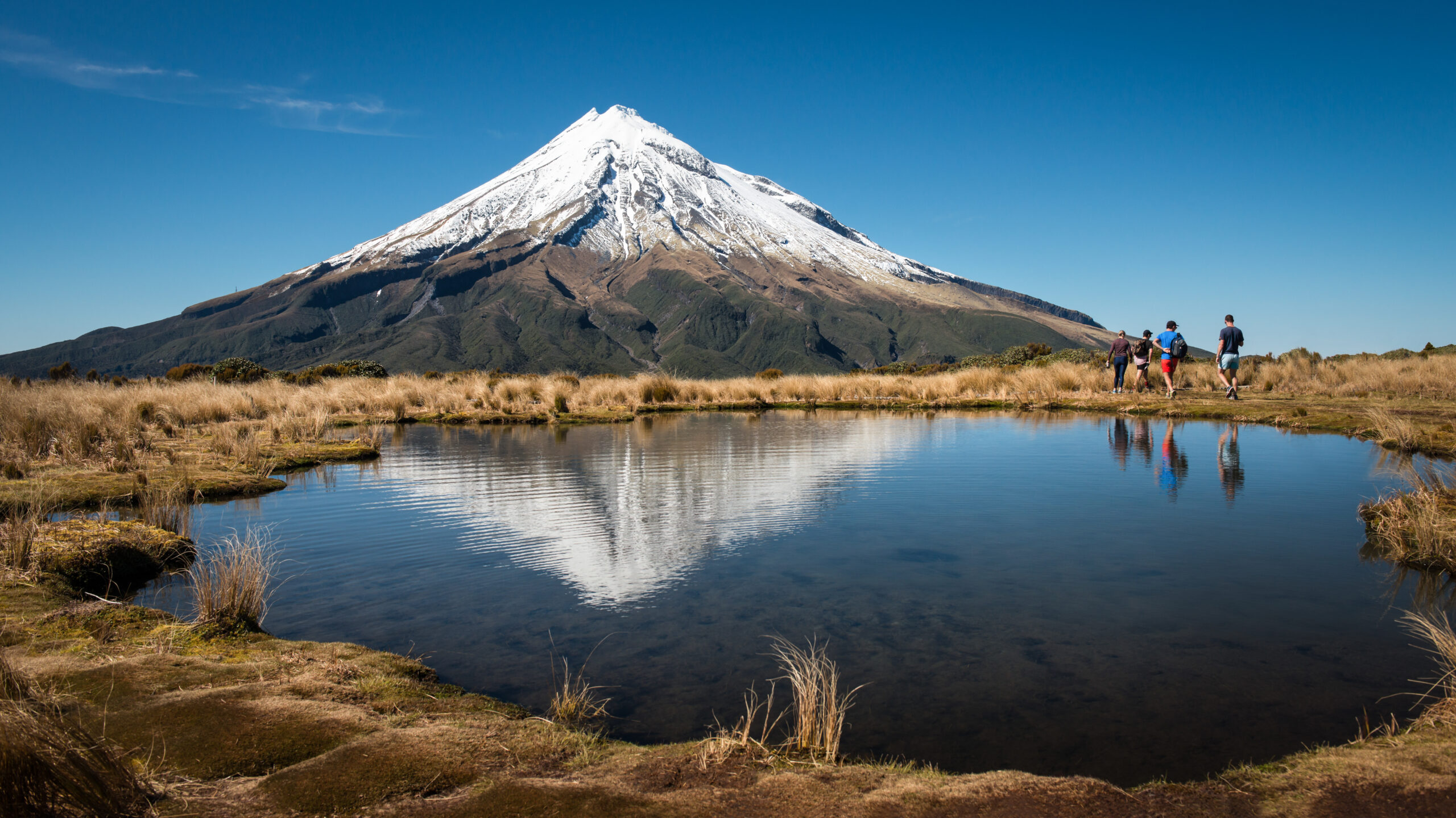
Pouākai is the Taranaki trip most hikers should plan first.
The tarn reflection is famous, but the route matters because it shows the full mountain environment: podocarp forest, moss, alpine wetland and an isolated volcanic cone. The Mount Taranaki hiking guide covers the summit, Pouākai routes and current North Egmont access in more depth.
Start with these six North Island hiking trips
These six form the backbone of a North Island hiking plan: two Tongariro routes, one Taranaki mountain family, one remote Great Walk, one classic hut trip and one rugged coastal track.
Tongariro Northern Circuit
Three or four days through volcanic terrain, with a live reopening issue around Mangatepopo and Oturere.
Plan the circuit →Day hike · TongariroTongariro Alpine Crossing
19.4 km, 7–8 hours, steep alpine terrain, a free booking recommendation and shuttle-driven summer access.
Plan the crossing →TaranakiMount Taranaki Hiking
Summit route, Pouākai Circuit, tarns, season and current North Egmont access.
Open the Taranaki guide →Great Walk · Te UreweraLake Waikaremoana
A one-way four-day journey with advance accommodation bookings and transport between separated trail ends.
Plan Waikaremoana →CoromandelCoromandel Pinnacles
A long day or simple overnight built around a bookable 80-bunk hut and a steep lookout finish.
Plan the Pinnacles →NorthlandCape Brett Track
Sixteen rugged kilometres to the cape, with a private-land walking fee on the first 10 km and optional boat access.
Plan Cape Brett →The Alpine Crossing and Northern Circuit solve different trips
One is a transport-dependent day across volcanic alpine terrain. The other is a hut-and-campsite journey that shares some of the same landscape but demands a different booking and weather strategy.
Tongariro Alpine Crossing
DOC describes the crossing as a high-fitness trip over steep, undulating terrain. The route climbs from Mangatepopo toward Red Crater at 1,886 m, descends loose volcanic scree past the Emerald Lakes and continues to Ketetahi.
Summer logistics: DOC recommends a free track booking for everyone. A booking is required to use a shuttle or guided-walk service. There is no summer parking for crossing hikers at Mangatepopo, so a shuttle is normally the cleanest plan.
Carry enough water for the route. Loose rock, exposure, strong wind and fast weather changes make turnaround judgment more important than mileage alone.
Winter is not a quieter summer crossing
Snow and ice can hide markers and turn slopes into slide terrain. DOC says winter users need alpine navigation, avalanche awareness, the equipment and skills to prevent a fall on ice, and clothing capable of handling sub-zero conditions.
For ordinary hikers visiting in winter, Taranaki Falls and lower walks are more sensible. A famous itinerary does not make the conditions suitable.
Stay on the track
The 2025 fires affected land around the start of the crossing. Hapū Ngāti Hikairo ki Tongariro placed a 10-year restorative rāhui over the affected area. Stay on formed tracks and out of fire-affected off-track terrain.
Do not add Ngauruhoe or Tongariro summit detours. The peaks are sacred to Ngāti Tūwharetoa, and DOC explicitly asks visitors not to climb them.
| Northern Circuit decision | What to know now |
|---|---|
| Normal trip length | Most walkers take 4 days / 3 nights or 3 days / 2 nights. Huts and campsites require bookings. |
| Current 2026 issue | DOC’s September 4 update says Mangatepopo Track is on course for a mid-December reopening, restoring the full loop. |
| Oturere | The new Oturere Hut and campsite are scheduled to open for bookings from December 18, 2026. |
| Before mid-December | Do not assume the standard circuit. Follow DOC emails, booking details and live alerts for the itinerary that applies to your date. |
| Winter | May to late October requires alpine skills, equipment and experience. Snow, ice, avalanche terrain and sub-zero temperatures are normal concerns. |
| Camping | Use designated campsites; camping is not allowed within 500 m of the track. |
The route is also a good reminder that a North Island trip benefits from flexibility. The static DOC route page can lag a fast-moving construction update, while booking emails may contain the detail that applies to a specific departure. Recheck the live alert immediately before the trip.
Separate the Pouākai hike from the summit decision
Taranaki is visually simple and operationally complicated. The cone looks direct, but fast weather, loose terrain, snow and ice make the summit a very different undertaking from the lower circuit and tarn hikes.
Pouākai Circuit
DOC describes Pouākai as a premier two-to-three-day tramp. The circuit crosses forest, the Ahukawakawa wetland and exposed alpine country. It is the strongest choice for hikers who want a full Taranaki trip without making the summit mandatory.
The circuit also has more room for weather decisions. A clouded-in tarn is disappointing; a clouded-in summit route can become a navigation and safety problem.
Summit climb
DOC identifies January through April as the main non-mountaineering window for fit, well-equipped trampers. The ascent gains roughly 1.6 vertical kilometres. Even in summer, crater ice and sudden weather can make the route much more serious than a normal trail summit.
North Egmont parking is constrained
Parking at the North Egmont road end is limited until December 2026 because of construction of the new visitor centre. DOC recommends carpooling or a shuttle. The temporary visitor centre remains open in the upper car park.
Freedom camping is prohibited at the North Egmont road end. Treat parking and overnight logistics as separate decisions.
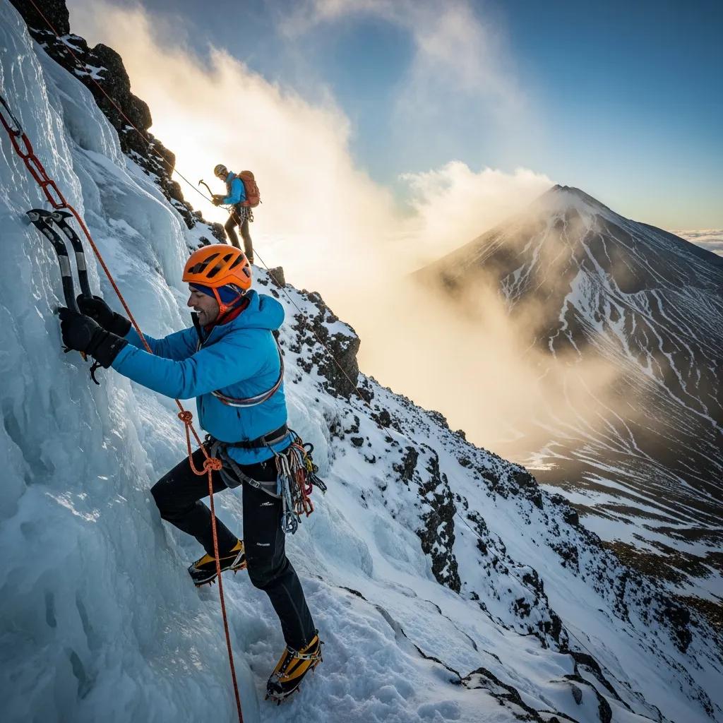
Snow changes Taranaki from a hike into a mountaineering objective.
DOC’s seasonal line is unusually clear: January through April is the principal window for fit, equipped trampers; May through December normally demands mountaineering experience and equipment. If your dates land in winter, move the hiking objective lower rather than treating the calendar as an inconvenience.
Lake Waikaremoana rewards travelers who solve transport first
This is not a simple national-park loop. It is a one-way journey in the homeland of Ngāi Tūhoe, and its identity is inseparable from Te Urewera.
A practical four-day itinerary
- Day 1: Onepoto to Panekire Hut
- Day 2: Panekire to Waiopaoa Hut
- Day 3: Waiopaoa to Marauiti Hut
- Day 4: Marauiti to Hopuruahine
Four huts and five campsites serve the track, and advance bookings are required.
The trail ends are about 30 km apart
Arrange the water taxi or shuttle before finalizing the overnight sequence. DOC notes that Hopuruahine road is currently unsuitable for 2WD vehicles, while water-taxi service is usually available from October through April rather than during winter.
That makes Onepoto the easier vehicle-access anchor for many independent trips, but the walking direction should still follow the best combination of weather, beds and transport.
Walk as a guest, not just a customer
Te Urewera is recognized in New Zealand law as a legal entity in its own right. Care for the area, including tracks and facilities, is carried out by Te Uru Taumatua, Ngāi Tūhoe’s operational entity. The Great Walk is an opportunity to understand that relationship as well as the scenery.
| Waikaremoana decision | Why it matters |
|---|---|
| Book all nights first | A gap in hut or campsite availability can break the entire one-way itinerary. |
| Then book transport | Water taxi and shuttle times determine which direction and final walking day work cleanly. |
| Do not assume 2WD north-end access | DOC currently says Hopuruahine road is unsuitable for 2WD vehicles. |
| Winter is different | Water-taxi service is normally October–April; winter transport and weather require a different plan. |
The Pinnacles and Cape Brett balance the volcanic mountains
Neither requires alpine altitude, but both are real hiking days. Use them when you want a hut, coastal ridge or forest objective without another weather-sensitive volcanic crossing.
Kauaeranga Kauri Trail / Pinnacles
The route follows historic steps and packhorse lines through the Kauaeranga Valley to the Pinnacles. A day out-and-back via Webb Creek takes roughly 6–7.5 hours; the more relaxed version stops at the serviced 80-bunk Pinnacles Hut.
The hut must be booked online. Current bookings extend through June 30, 2027, and fees vary by season and day of week. That is a reason to use the live DOC booking page rather than an old fixed price.
Cape Brett Track
The full track begins at Oke Bay / Rawhiti and traverses a rugged ridge to the cape. The first 10 km crosses private land owned by Te Rawhiti 3B2 Ahu Whenua Trust; the final 6 km from Deep Water Cove is public conservation land.
The current walkway fee is NZ$50 for adults and NZ$20 for ages 5–17. A boat to Deep Water Cove can shorten the trip and avoids the private-land walking fee, but it replaces the trailhead drive with a boat-timing decision.
Secure the hut before fixing the road trip
Pinnacles and Cape Brett huts can fill on attractive weekends. Treat the hut night as the anchor, then add Auckland, Rotorua, Coromandel or Bay of Islands travel around it. That is more reliable than fixing a hotel sequence first and hoping the hut is still available.
Summer opens the alpine menu; winter shifts the trip lower
The North Island does not have one hiking season. Tongariro and Taranaki can become genuine alpine terrain while coastal and forest routes remain viable in completely different conditions.
| Period | Best choices | Why go | What changes |
|---|---|---|---|
| December–February | Tongariro, Taranaki, Great Walks, Pinnacles, Cape Brett | Broadest access to high trails and long daylight. | High demand, hut bookings, volcanic heat exposure and fast alpine weather. |
| March–April | Taranaki summit, Tongariro, Waikaremoana, coast | Excellent shoulder-season balance; Taranaki summit still sits inside DOC’s January–April hiking window. | Shorter days and more autumn variability late in the period. |
| May–October | Rangitoto, coast, forest, selected lower mountain walks | Lower routes can remain excellent between weather systems. | Tongariro and upper Taranaki become winter alpine terrain; snow, ice and avalanche skills may be required. |
| November | Lower Tongariro, Coromandel, Northland, Rotorua | Spring road-trip month with growing daylight. | Upper mountains may still hold snow; treat summer timing as a trend, not permission. |
The best itinerary is therefore seasonal in two ways: choose the right route for the month, then choose the right day for the mountain. A North Island road trip with three fixed alpine days and no backups is less robust than one with flexible Tongariro and Taranaki windows plus lower alternatives.
What needs a reservation, shuttle or fee?
The strongest North Island hiking trips often fail at the logistics stage before they fail on the trail. Lock the scarce item first: Great Walk bed, hut, shuttle or private-land access.
| Route | Current planning rule | First move |
|---|---|---|
| Tongariro Alpine Crossing | Free booking recommended; booking required for shuttle/guided services; no summer crossing-hiker parking at Mangatepopo. | Choose a weather-flexible date and shuttle. |
| Northern Circuit | Bookings open for 2026/27; latest DOC update targets full-loop reopening mid-December and Oturere from Dec 18. | Check exact-date route status before transport. |
| Lake Waikaremoana | Huts and campsites require advance booking; one-way ends require transport. | Match beds with water taxi/shuttle. |
| Pinnacles | 80-bunk hut requires online booking; bookings open through June 30, 2027. | Book the hut before hotel nights. |
| Cape Brett | Private-land walkway fee NZ$50 adult / NZ$20 youth for the full route; hut is separate. | Choose full land route or Deep Water Cove boat access. |
| Taranaki | North Egmont parking constrained until Dec 2026; summit itself does not use a general hiking reservation. | Check forecast, access and shuttle/parking. |
One North Island hotel base cannot serve these hikes
New Zealand looks compact on a world map, but mountain roads and one-way tracks make backtracking expensive in time. Move the base with the hiking region.
Whakapapa / National Park Village / Tūrangi
Use Whakapapa for closest park access, National Park Village for transport connections and shuttles, or Tūrangi when combining Tongariro with Lake Taupō. The right choice depends on whether the crossing, Northern Circuit or a short park day is the anchor.
New Plymouth
The practical urban base for North Egmont access, supplies, weather-day flexibility and multiple Taranaki trailheads. It also makes a failed summit-weather day less disruptive because lower coastal and forest options remain nearby.
Lake Waikaremoana area
Stay close to the Great Walk before and after the trip. The remoteness is part of the experience, and a distant city hotel does not solve the early transport day or one-way finish.
Thames / Kauaeranga Valley
Best for the Pinnacles and shorter Coromandel forest walks. If the hut is booked, the road-end logistics are straightforward enough to build around one or two nights in the area.
Paihia / Russell / Rawhiti
Paihia and Russell work for a broader Northland trip; Rawhiti is the actual Cape Brett trailhead area. A boat to Deep Water Cove can change which base makes the most sense.
Auckland + Hauraki Gulf
Use Auckland for Rangitoto and as the flight/road-trip gateway. It is not a sensible daily base for Tongariro, Taranaki or Cape Brett, even when a map makes the island look small.
Lodging principle: reserve the scarce hut or Great Walk bed first, then choose the gateway accommodation that supports it. That prevents a common planning mistake: booking a neat chain of hotels before discovering that the key trail night is unavailable.
Three North Island hiking itineraries that make geographic sense
Do not collect trails at random. Pair routes that share a road corridor and give each mountain a weather backup.
Tongariro focus
Base around Whakapapa or National Park Village. Give the Alpine Crossing a flexible weather window, use Tama Lakes or Taranaki Falls as backups, and read the Mount Ruapehu guide for the neighboring mountain context rather than forcing a summit into the itinerary.
Tongariro + Taranaki
Spend three or four days around Tongariro, then move west to New Plymouth for Pouākai and lower Taranaki routes. Only add the Taranaki summit when season, forecast, ground conditions and personal skill all align.
Volcanoes + forest + coast
Combine Tongariro with Taranaki, then choose Coromandel/Pinnacles or Northland/Cape Brett. Add Waikaremoana only if you can give the remote Great Walk the transport and accommodation planning it deserves.
The North Island is also a good bridge between hiking and larger Oceania mountain goals. The Oceania mountain collection connects these walking landscapes with the major peaks of Australia and New Zealand without pretending that a tramping route and a technical alpine climb are the same activity.
Check these before departure
Track openings, volcanic hazards, weather, hut availability, road access and rāhui can change after an evergreen article is published.
Planning North Island hiking
Choose the route family first, then verify the exact forecast, booking and access status before travel.
What is the best hike on New Zealand's North Island?
For most first-time visitors, the Tongariro Alpine Crossing is the strongest single-day hike. It combines volcanic terrain, high alpine scenery and a clear point-to-point objective. The Northern Circuit is better if you want a multi-day trip.
Is the Tongariro Alpine Crossing open year-round?
The track can be accessed year-round, but May to late October is winter terrain. DOC says alpine skills, equipment and experience are essential in winter because snow, ice, avalanche terrain and sub-zero temperatures are common.
Do I need to book the Tongariro Alpine Crossing?
DOC recommends a free track booking for everyone using any part of the crossing. A booking is required if you are using a shuttle or guided-walk service. In summer there is no parking for crossing hikers at Mangatepopo.
What is happening with the Tongariro Northern Circuit in 2026?
DOC's 4 September 2026 update says the full loop is expected to reopen in mid-December after fire repairs on Mangatepopo Track. The new Oturere Hut and campsite are scheduled to open for bookings from 18 December 2026.
When is the best time to hike Taranaki Maunga?
DOC identifies January through April as the main window for fit, well-equipped non-mountaineers attempting the summit. From May through December, snow and ice normally require mountaineering experience and equipment.
Is the Lake Waikaremoana Track a circuit?
No. It is a one-way Great Walk between Onepoto and Hopuruahine, with the ends about 30 km apart by road. Hikers should book huts or campsites and arrange the water taxi or shuttle before the trip.
Do I need to book the Pinnacles Hut?
Yes. Pinnacles Hut is an 80-bunk serviced hut and must be booked online in advance. DOC has bookings open through 30 June 2027, and the nightly fee varies by season and weekday versus weekend.
How much does it cost to walk Cape Brett Track?
The first 10 km crosses private land managed by the Te Rawhiti 3B2 Ahu Whenua Trust. The current walkway fee is NZ$50 for adults and NZ$20 for ages 5–17. The public conservation section from Deep Water Cove to Cape Brett has no walkway fee.
Can I climb Ngauruhoe or Tongariro as a side trip?
DOC states that summiting Mount Ngauruhoe and Mount Tongariro is disrespectful and unacceptable to Ngāti Tūwharetoa, for whom these peaks are sacred. This guide does not recommend summit side trips.
Where should I stay for North Island hiking?
Use Whakapapa, National Park Village or Tūrangi for Tongariro; New Plymouth for Taranaki; accommodation around Lake Waikaremoana for Te Urewera; Thames or Kauaeranga for the Pinnacles; Paihia, Russell or Rawhiti for Cape Brett; and Auckland for Rangitoto.
Put the hike, booking date and weather backup in one plan.
The North Island rewards flexible travelers. Save the primary hike, a lower-weather alternative, the scarce booking and the transport plan before the road-trip itinerary becomes fixed.
Open My Climb →Compare the next hiking region or mountain objective
Continue into the South Island or compare another mountain-hiking region, then use the two New Zealand mountain resources when the trip shifts from trails toward summit objectives.
Was this helpful?
🏔Related peaks nearby
🧭Explore & compare
Global Summit Guide is an independent mountaineering resource founded in 2026. The team combines first-hand trekking and climbing experience with in-depth research and professional health and nutrition review to help climbers choose objectives, prepare properly, and stay safe.
Health, altitude, and nutrition content is reviewed by Taylor Ludlow (Registered Nurse) and Brigg Hoopes (Nutritionist).
What We Don't Know Yet
Mountain information changes quickly. This box explains the limits of what this page can responsibly promise.
- Visa, passport, vaccination, border, insurance, and local transportation rules may change before your trip.
- Route conditions, snowpack, closures, and weather can change quickly after this page is updated.
- Permit rules, fees, quotas, and reservation windows may change between review cycles.
- Operator availability, pricing, guide ratios, and cancellation terms can change by season.
- Your fitness, altitude response, risk tolerance, and experience level may change what is safe or realistic.
Verify current conditions with official land managers, guide services, local forecasts, and current route reports before booking or climbing.
Mountaineering, rock and ice climbing, glacier travel, and high-altitude activity are inherently dangerous and can result in serious injury or death. The information on Global Summit Guide is provided for general informational and educational purposes only and is not a substitute for professional instruction, qualified guiding, proper equipment, or your own judgment and experience.
Route conditions, weather, snowpack, permits, regulations, and hazards change constantly and may differ from what is described here. Details may be incomplete, out of date, or contain errors. Always verify current information with local authorities, certified guides, and official sources before making any decision in the mountains.
Nothing on this site is medical, legal, or financial advice. Our fitness, acclimatization, altitude, and nutrition content is general in nature; consult a qualified physician before beginning any strenuous exercise program or exposing yourself to high altitude.
You are solely responsible for your own safety and decisions. To the fullest extent permitted by law, Global Summit Guide and its team accept no liability for any loss, injury, damage, or expense arising from use of, or reliance on, this information. By using this site you acknowledge these risks and accept these terms.
Some links on this site may be affiliate links. If you buy through them we may earn a small commission at no extra cost to you; this never affects our recommendations.
Global Summit Guide recommendation path
Next Best Mountain to Research
Use these recommendations to continue the right planning path instead of stopping on one page.
Use current permit, weather, route, and operator information before booking or climbing.
Search Flights, Hotels & Rental Cars
Have the mountain or destination picked? Use Expedia to compare the flights, lodging and rental cars that fit your actual trip dates. For mountain travel, consider arriving early enough for delays and adding a buffer night after the climb before a fixed flight home.
Compare current flight, hotel and car options.
Affiliate disclosure: Global Summit Guide may earn a commission if you book through this link, at no additional cost to you.