
Best Mountains Near Salt Lake City: The Complete Wasatch Hiking Guide
The definitive guide to mountains near Salt Lake City — organized by the five canyons that cut into the Wasatch Range. From 1-hour Ensign Peak to the 14-hour Lone Peak expedition, every mountain you can reach from Salt Lake City, with access routes, difficulty tiers, and what makes each canyon distinctive.
canyons
accessible
downtown
range
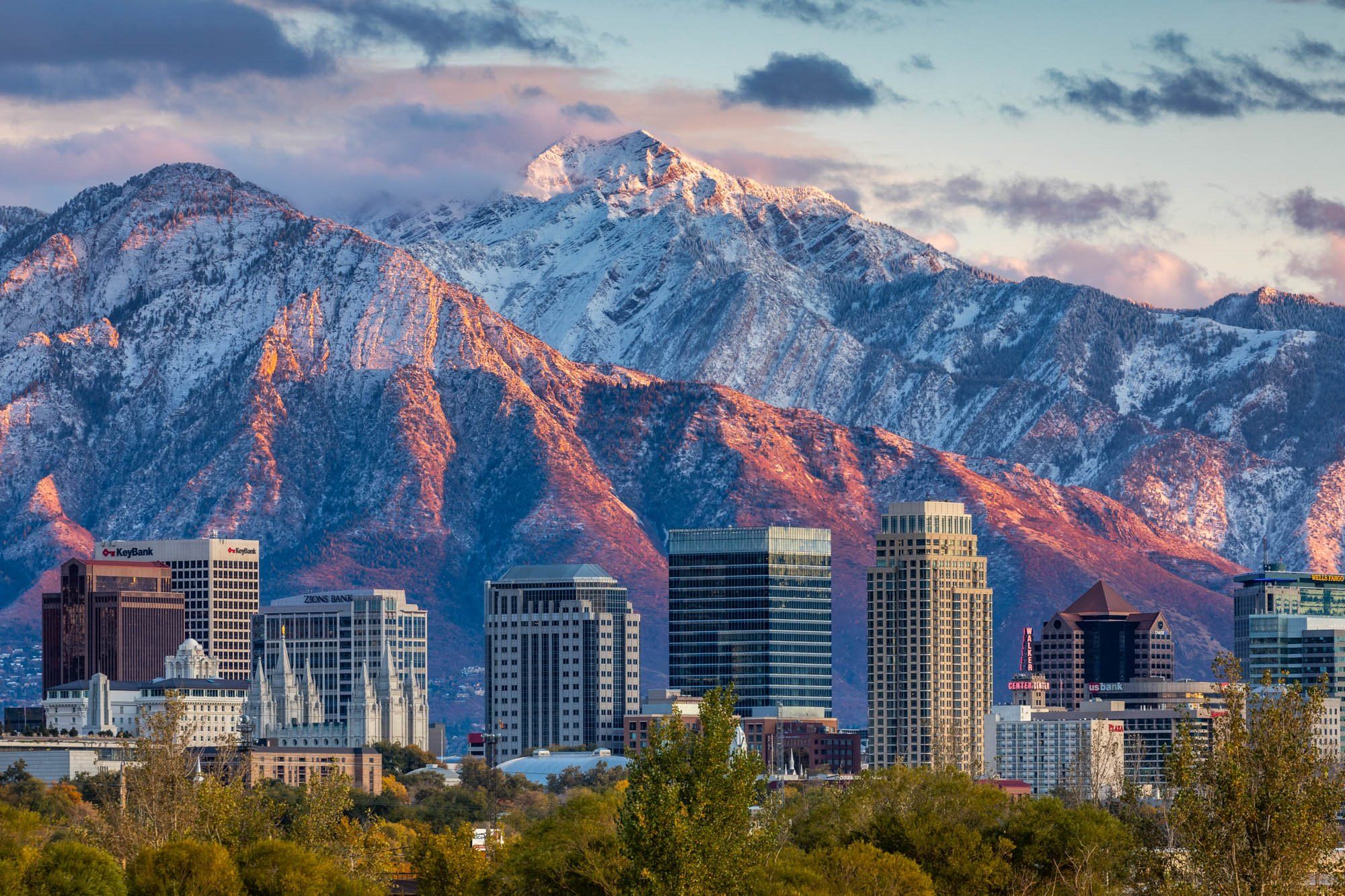
Salt Lake City sits at the base of one of North America’s most accessible mountain ranges — the Wasatch rises 7,000 feet above the valley floor, with summit trailheads reachable from downtown in 15-90 minutes. Five major canyons cut into the range, each offering a different character of mountain hiking: Parleys, Mill Creek, Big Cottonwood, Little Cottonwood, and American Fork. Understanding these canyons is the key to understanding Wasatch hiking — each defines a geography of trailheads, peak difficulty, and canyon personality. This guide walks through every canyon, the signature mountains you can reach from each, and how to match your experience level to the right peak.
Mountain data verified against Uinta-Wasatch-Cache National Forest trail management records, US Geological Survey topographic databases, and Utah County Visitors Bureau documentation. Drive times reflect Google Maps 2026 averages from downtown Salt Lake City (Temple Square) during non-rush hours. Trailhead fee information confirmed from Salt Lake County Parks & Recreation and SLC Public Utilities (watershed regulations). Wildlife data draws from Utah Division of Wildlife Resources and Wasatch Mountain Club observations. Reviewed by Utah hiking community members and local guides. Fact-check date: April 19, 2026.
The Wasatch Front: Your Home Range
The Wasatch Range stretches approximately 160 miles from the Utah-Idaho border south through central Utah. The “Wasatch Front” specifically refers to the western face of the range bordering the Salt Lake Valley, Provo/Orem Utah Valley, and Ogden Weber Valley.
Key Wasatch Front facts
- Salt Lake City elevation: 4,226 ft (downtown). Even low-elevation trails require substantial elevation gain from valley.
- Highest peaks visible from SLC: Lone Peak (11,253 ft), Twin Peaks (11,330 ft), Mount Timpanogos (11,752 ft, south), Mount Nebo (11,928 ft, far south)
- Access corridor: Five canyons cutting into the range, each with different personality and regulations
- Weather pattern: Summer afternoon thunderstorms (critical safety factor), snow November through May on higher peaks
- Wildlife: Mountain lions, black bears, moose, mule deer, elk, Rocky Mountain goats (on Timpanogos specifically)
- Protection status: Much of the range is protected wilderness including Mount Olympus Wilderness, Twin Peaks Wilderness, Lone Peak Wilderness, Mount Timpanogos Wilderness
- Watershed rules: Little Cottonwood and Parleys canyons have no-dog restrictions (drinking water protection)
The Five Canyons: Your Access to the Range
Understanding the canyons is understanding Wasatch hiking. Each canyon has distinct character, regulations, and defining peaks.
Parleys Canyon
Parleys Canyon carries I-80 east out of Salt Lake City toward Park City. As a watershed canyon, it has strict dog restrictions (no dogs permitted) and fewer trailhead options than the other canyons. Peaks accessed tend to be lower elevation but provide sweeping valley views. Best for quick after-work hikes rather than major summit pursuits.
Key Peaks Accessed
- Mount Wire — 7,143 ft · Red Butte area
- Red Butte / Living Room — City views
- Ensign Peak — 5,417 ft · Historic 1-mile hike
- Little Mountain — 7,241 ft · Connects Parleys to Emigration
Mill Creek Canyon
Mill Creek Canyon is Salt Lake City’s most popular hiking canyon — central location, reasonable fee, dog-friendly regulations (odd days dogs off-leash, even days leashed), and excellent moderate-to-strenuous peaks. The $5 canyon fee applies to vehicles. Runs east from the Brighton/Rainbow Trail entrance.
Trail character: forested lower sections, moderate grades, peaks in the 8,000-10,300 ft range. Best canyon for first-time SLC hikers building toward bigger peaks. Church Fork, Desolation, and Alexander Basin are popular trailheads.
Key Peaks Accessed
- Grandeur Peak — 8,299 ft · SLC classic
- Mount Aire — 8,621 ft · Accessible moderate
- Mount Raymond — 10,241 ft · Strenuous
- Gobblers Knob — 10,246 ft · Pairs with Raymond
- Thaynes Peak — Moderate peak
- Pioneer Peak — Sparse use
Big Cottonwood Canyon
Big Cottonwood Canyon is wider and longer than Mill Creek, stretching east to Solitude and Brighton ski resorts. No canyon fee. Offers excellent moderate and strenuous peaks including several 11,000+ foot summits. Popular for both Salt Lake and Utah County hikers due to central Wasatch location.
Trail character: Starts from lower Big Cottonwood (Donut Falls area), progresses through mid-canyon access to Lake Blanche and Twin Peaks, extends up to Brighton basin with summit-region hikes to Sunset Peak, Clayton Peak, and ski resort peaks.
Key Peaks Accessed
- Twin Peaks (South) — 11,330 ft · SLC County highest
- Dromedary Peak — 11,107 ft · Technical
- Lake Blanche basin peaks — Moderate
- Sunset Peak — 10,648 ft · Brighton
- Clayton Peak — 10,721 ft · Brighton
- Mount Raymond — 10,241 ft · Via Butler Fork
Little Cottonwood Canyon
Little Cottonwood is the premier Wasatch canyon for serious hiking. Home to Alta and Snowbird ski resorts, it accesses the range’s highest peaks including Lone Peak, Pfeifferhorn, and the Twin Peaks area. Strict watershed regulations apply — no dogs permitted anywhere in the canyon. Terrain is more dramatic than other canyons with glacial cirques, exposed ridges, and class 3 scrambling opportunities.
This canyon separates weekend hikers from serious mountain enthusiasts. Every peak here is a commitment requiring strong fitness, early starts, and weather awareness.
Key Peaks Accessed
- Pfeifferhorn — 11,326 ft · Class 3 scramble
- Lone Peak — 11,253 ft · 15 mi RT epic
- Sunrise Peak — 11,275 ft · Sunrise viewpoint
- White Baldy — 11,321 ft · Ridge scramble
- Red Baldy — 11,171 ft · Ridge connect
- American Fork Twin Peaks — 11,433 ft · Complex
American Fork Canyon
American Fork Canyon sits at Salt Lake County’s southern border, officially in Utah County but within 45 minutes of downtown SLC and therefore commonly accessed by Salt Lake hikers. Gateway to Mount Timpanogos and the Alpine Loop Scenic Byway (SR-92) connecting to Provo Canyon. $10 canyon fee (or America the Beautiful pass). Timpanogos Cave National Monument at canyon’s lower entrance.
See our complete Timpanogos challenge guide for the canyon’s most famous peak.
Key Peaks Accessed
- Mount Timpanogos — 11,752 ft · Wasatch #2
- Box Elder Peak — 11,101 ft · Alpine Loop
- American Fork Twin Peaks — 11,433 ft · West
- Devil’s Castle — 10,920 ft · Alta/AFork
- Mill Canyon Peak — 10,357 ft · Moderate
- Mount Baldy (Alta) — 11,068 ft · Ski area
Matching Peaks to Your Experience: Four Difficulty Tiers
Salt Lake City’s mountains span the full range from evening strolls to multi-hour expeditions. Work through the tiers systematically rather than jumping to the hardest peaks as your first mountain hikes.
Under 6 Miles
Examples: Ensign Peak, Living Room Trail, Ferguson Canyon, lower Mill Creek trails. Best for: Beginners, families, evening hikes.
6–8 Miles
Examples: Mount Wire, Grandeur Peak, Mount Aire, Desolation Trail. Best for: Regular weekend hikers.
7–10 Miles
Examples: Mount Olympus, Gobblers Knob, Mount Raymond, Sunset Peak. Best for: Experienced hikers.
10+ Miles
Examples: Lone Peak, Pfeifferhorn, Timpanogos, Twin Peaks. Best for: Advanced mountain hikers with proven endurance.
Signature SLC Peaks: Quick Reference
The most iconic mountains you can reach from Salt Lake City, with essential at-a-glance details:
Tier 1 — Quick Peaks (under 3 hours)
Ensign Peak
Historic first-view peak. Pioneer significance. Family-friendly. Stunning valley views at sunset.
Living Room Trail
Iconic SLC short hike. Stone ‘living room’ arrangement at top. Year-round accessible.
Mount Wire
Red Butte area. Sweeping valley views. Good beginner mountain progression.
Tier 2 — Moderate Peaks (4-6 hours)
Grandeur Peak
Classic SLC moderate peak. Multiple approach routes. Mill Creek Canyon access.
Mount Aire
Mill Creek Canyon. Accessible summit with meadow approach. Dog-friendly on odd days.
Sunset Peak
Brighton ski area access. Higher elevation but shorter distance. Wildflower meadows.
Tier 3 — Strenuous Peaks (6-10 hours)
Mount Olympus
SLC’s iconic peak. Final scramble to summit. Visible from entire valley. Demanding grade.
Mount Raymond
Often paired with Gobblers Knob. Mill Creek or Butler Fork approach. Good second-tier challenge.
Gobblers Knob
Pairs with Raymond on loop hike. Distinctive exposed summit. Central Wasatch views.
Tier 4 — Expert Peaks (10-15 hours)
Lone Peak
SLC’s ultimate peak challenge. Jacob’s Ladder or Draper approach. 11-14 hours. Commit.
Pfeifferhorn
Iconic class 3 scramble ridge. Red Pine Lake approach. Advanced mountaineering skills.
Twin Peaks (South)
Highest peak in SLC County. Little Cottonwood approach. Full-day commitment.
When to Hike the Wasatch
| Month | Lower peaks (under 8,000 ft) | Mid peaks (8,000–10,000 ft) | High peaks (10,000+ ft) |
|---|---|---|---|
| April | Accessible, muddy | Snow patches, microspikes | Mountaineering conditions |
| May | Good conditions | Late snow melting | Still winter conditions |
| June | Excellent | Good, scattered snow | Late-June accessible |
| July | Hot, start early | Prime season | Prime season |
| August | Hot, thunderstorms | Prime season | Prime season |
| September | Excellent | Excellent | Optimal conditions |
| October | Fall colors, cool | Fall colors | First snow likely late-Oct |
| November | Cold, snow possible | Winter conditions beginning | Closed for winter |
| December-March | Snowshoeing | Technical conditions | Mountaineering only |
Utah’s summer weather pattern creates afternoon convection storms producing dangerous lightning above treeline. The critical rule for summer hiking: summit before 11:00 AM and descend below treeline by noon on thunderstorm-prone days. Start hiking at 4:00-6:00 AM in July-August. Check radar before departing. If storms develop, descend immediately regardless of summit proximity. Lightning fatalities occur in the Wasatch annually — this is not a theoretical risk. Check NOAA Salt Lake forecasts and Mountain-Forecast.com for peak-specific predictions.
Trailhead & Logistics Tips
- Start early: 4:00-7:00 AM depending on peak and season. Beats heat, thunderstorms, and crowds simultaneously.
- Weekday advantages: Most popular SLC trailheads (Mount Olympus, Grandeur, Lake Blanche) fill by 7-8 AM on summer Saturdays. Weekday hikes avoid most parking issues.
- Canyon fees: Mill Creek $5, American Fork $10, Little Cottonwood and Big Cottonwood no fee. America the Beautiful pass covers most federal sites but not Mill Creek.
- Dog restrictions: Little Cottonwood and Parleys — no dogs anywhere (watershed). Mill Creek — odd days off-leash, even days leashed. Big Cottonwood — dogs permitted on trails. American Fork — dogs on leash.
- Water: Most Wasatch streams are watershed-protected — not for drinking. Carry 2-4 liters depending on peak distance.
- Cell coverage: Spotty on most peaks. Don’t rely on phone for navigation or emergencies. Download offline maps (AllTrails, Gaia GPS).
- Parking at popular trailheads: Mount Olympus, Grandeur (Church Fork), and Lake Blanche trailheads fill early on weekends. Arrive by 6-7 AM or choose less popular alternatives.
- Altitude: Coming from sea level? Arrive 1-2 days early. Even Salt Lake Valley’s 4,500 ft helps with 10,000+ ft peak attempts.
- Snow conditions: Check Utah Avalanche Center (utahavalanchecenter.org) for winter/early spring conditions. Avalanche terrain is real on Cottonwood and American Fork peaks.
- Wildlife awareness: Moose are the most commonly aggressive wildlife — more injuries than bears/lions. Give them 100+ feet minimum.
Salt Lake City Mountains FAQ: Your Common Questions Answered
What is the best mountain to hike near Salt Lake City?
The best mountain to hike near Salt Lake City depends on your experience level, but Mount Olympus (9,026 ft) is the most iconic SLC-proximate peak — visible from Salt Lake Valley, accessible from the east bench in 15 minutes, and achievable in a single long day. Top recommendations by category: (1) Iconic SLC peak: Mount Olympus via Olympus Trail — 7 miles RT, 4,200 ft gain, 6-8 hours. Final 0.3-mile scramble to summit. (2) Best moderate peak: Grandeur Peak — 6 miles RT, 2,500 ft gain, 4-5 hours. Accessible from multiple trailheads. (3) Best beginner-friendly: Mount Wire via Red Butte — 6 miles RT, 1,800 ft gain, 3-4 hours. Sweeping SLC views. (4) Best advanced peak: Lone Peak (11,253 ft) — 15 miles RT, 5,700 ft gain, 11-14 hours. Significant commitment. (5) Best ridge scramble: Pfeifferhorn (11,326 ft) — 10 miles RT, 4,500 ft gain, class 3 scrambling. (6) Best summit view: Mount Timpanogos (11,752 ft) — 14 miles RT but technically in Utah County, 1 hour south of SLC. (7) Best short quick hike: Ensign Peak — 1 mile RT, 400 ft gain, 1 hour. Historic first view of Salt Lake Valley. (8) Best dog-friendly: Millcreek Canyon peaks (Mount Aire, Grandeur from Millcreek) — leash laws enforced. Most SLC hikers eventually work through multiple peaks rather than focusing on one.
How do you access Salt Lake City mountains by canyon?
Salt Lake City’s mountains are accessed through five main canyons cutting into the Wasatch Range, each offering different peaks and character. The five canyons in order from north to south: (1) Parleys Canyon (I-80 east) — Access to Mt. Wire, Red Butte, northern Wasatch peaks. Easy freeway access, generally lower elevation peaks. Upper Parleys has some hiking but limited peak summit options. (2) Mill Creek Canyon (SR-190) — Access to Grandeur Peak, Mount Aire, Mount Raymond, Gobblers Knob, Church Fork. $5 canyon fee, dog-friendly (odd days dogs off-leash, even days leash required), multiple trailheads within 30 minutes of downtown SLC. The most popular canyon for Salt Lake hikers seeking moderate peaks. (3) Big Cottonwood Canyon (SR-190) — Access to Brighton, Solitude, Lake Blanche, Twin Peaks, Dromedary Peak, Sunset Peak. No fee, wider and longer than Mill Creek, extends to Brighton and Solitude ski areas. Popular for longer and higher peaks. (4) Little Cottonwood Canyon (SR-210) — Access to Snowbird, Alta, White Pine, Red Pine, Maybird Gulch, Pfeifferhorn, Lone Peak area. No fee but watercraft/dog restrictions (watershed), most challenging canyon for hikers, home to highest SLC-accessible peaks. (5) American Fork Canyon (SR-92) — Access to Mt. Timpanogos, Timpanogos Cave, Alpine Loop peaks. $10 fee, located at Salt Lake County’s southern border, technically Utah County. Most SLC hikers access multiple canyons over time, matching canyon character to their hike preferences.
How hard is Mount Olympus in Salt Lake City?
Mount Olympus is a strenuous day hike — one of Salt Lake City’s most physically demanding popular peaks. Difficulty details: (1) Distance: 7 miles round trip via the main Olympus Trail. (2) Elevation gain: Approximately 4,200 feet — one of SLC’s steepest grade-per-mile hikes. (3) Summit: 9,026 feet elevation. (4) Duration: 6-8 hours typical for average hikers; 4-5 hours for fit experienced hikers; 8-10 hours possible for slower pace. (5) Terrain: Switchback trail for most of climb, then scramble to summit over loose rock. Final 0.3 miles requires class 2-3 scrambling. (6) Exposure: Some class 3 scrambling near summit with moderate exposure. Not recommended for acrophobic hikers. (7) Starting point: Olympus Trailhead at approximately 5,000 feet on Wasatch Boulevard (east bench of SLC). Why Olympus is demanding: (8) Steep grade throughout — relentless uphill on ascent. (9) Mostly exposed to sun (minimal shade) — hot in summer. (10) Water sources very limited — carry 3-4 liters. (11) Summit scramble intimidates some hikers. (12) Descent on loose rock is knee-punishing. Preparation recommendations: (13) Multiple prior hikes of 5+ miles with 2,000+ ft gain before attempting. (14) Trekking poles essential. (15) Start before dawn in summer to avoid heat. (16) Bring food for 8+ hours. Success rate: approximately 70% of hikers reach the summit. Main turn-around reasons: fatigue on ascent, discomfort with summit scramble, afternoon thunderstorms, time pressure. The view from Olympus summit of the entire Salt Lake Valley is considered one of Utah’s most rewarding.
What is the highest peak near Salt Lake City?
The highest peak in the immediate Salt Lake City vicinity (Salt Lake County) is Mount Nebo South Peak at 11,928 feet — though technically in Juab County, it’s considered part of the southern Wasatch accessible from SLC in about 90 minutes. Highest peaks by geographic proximity: (1) Mount Nebo (11,928 ft) — Highest Wasatch peak, southern Wasatch, 90 minutes south of SLC via I-15. Technically in Juab County but grouped with SLC-area mountains. (2) Mount Timpanogos (11,752 ft) — Second-highest Wasatch, 60 minutes south in Utah County, iconic from SLC perspective. (3) Box Elder Peak (11,101 ft) — Southern Wasatch on Alpine Loop. (4) American Fork Twin Peaks (11,433 ft — west peak) — Technical scramble peak accessible from Little Cottonwood or American Fork canyons. (5) Dromedary Peak (11,107 ft) — Little Cottonwood Canyon. (6) Twin Peaks (11,330 ft) — Little Cottonwood. (7) Pfeifferhorn (11,326 ft) — Little Cottonwood, iconic class 3 scramble. (8) Lone Peak (11,253 ft) — Little Cottonwood or Alpine access, significant commitment. (9) Bighorn Peak (11,051 ft) — Little Cottonwood. Highest peaks entirely within Salt Lake County: (10) The Twin Peaks (11,330 ft) — South Twin is highest in SLC County proper. (11) Sunrise Peak (11,275 ft) — Little Cottonwood. Urban proximity note: (12) Grandeur Peak (8,299 ft) is often cited as the ‘closest’ SLC mountain — accessible from Mill Creek Canyon in 30 minutes from downtown, though much lower than the Cottonwood peaks. Salt Lake City sits at 4,226 ft elevation, so even lower peaks involve substantial elevation gain.
When is the best time to hike near Salt Lake City?
The best time to hike mountains near Salt Lake City is June through October, with the sweet spot being mid-July through mid-September. Seasonal guide: (1) April-May: Lower foothill trails accessible, but higher peaks have snow and unstable avalanche conditions. Mount Wire, Ensign Peak, lower Mill Creek Canyon trails viable. Don’t attempt Olympus, Grandeur summit, or Cottonwood peaks. (2) June: Snow melts off most peaks, wildflowers begin. Mount Olympus typically doable by mid-June. Higher Cottonwood peaks still have snow patches. Mosquitos active in wet areas. (3) July-August: Peak hiking season. All SLC peaks accessible. Afternoon thunderstorms frequent — start before sunrise. Hottest temperatures; hydration critical. Wildflowers at peak. (4) September: Optimal month for most hikers. Cooler mornings, less thunderstorm activity, still 12+ daylight hours. Early autumn color begins. (5) October: Fall color spectacular, crisp air, fewer crowds. Shorter days require earlier starts. First snowfall possible late October on higher peaks. (6) November-March: Winter/snow conditions. Many trailheads inaccessible due to canyon road conditions. Snowshoeing or technical mountaineering required for most peaks. Avalanche terrain on most Cottonwood peaks. Daily timing considerations: (7) Summer starts: 4:00-6:00 AM to beat heat and thunderstorms. (8) Fall starts: 6:00-7:00 AM adequate for shorter peaks. (9) Sunrise summits: Popular on Grandeur, Ensign, Mt. Wire — 1-2 hour start before sunrise. (10) Weekday advantage: Dramatically fewer crowds on popular peaks. Weekends on Mount Olympus or Grandeur can feel congested. Check conditions: (11) Wasatch Mountain Club trail reports. (12) Utah Avalanche Center for winter conditions. (13) National Weather Service Salt Lake forecast pages.
Can beginners hike mountains near Salt Lake City?
Yes, beginners have excellent options for mountain hiking near Salt Lake City — the Wasatch Range offers a progression from 1-mile easy hikes to 15+ mile demanding summits. Beginner-appropriate SLC peaks: (1) Ensign Peak — 1 mile RT, 400 ft gain, 1 hour. Historic peak with views of entire Salt Lake Valley. Excellent first-mountain hike. (2) Mount Wire — 6 miles RT, 1,800 ft gain, 3-4 hours. Sweeping city views, well-maintained trail. Perfect progression from Ensign Peak. (3) Grandeur Peak via Church Fork — 6 miles RT, 2,500 ft gain, 4-5 hours. Accessible from Mill Creek Canyon with multiple options for shorter variations. (4) Living Room Trail — 2.5 miles RT, 1,000 ft gain. Less summit-focused but classic SLC hike ending at stone ‘living room’ arrangement. (5) Desolation Trail to Mount Aire — 7 miles RT, 2,000 ft gain. Mill Creek Canyon. Moderate with achievable summit. (6) Lower Little Cottonwood peaks like Alpine Overlook. Beginner progression strategy: (7) Start with 1-3 mile hikes with 500-1,000 ft gain like Ensign Peak. (8) Progress to 4-6 mile hikes with 1,500-2,500 ft gain like Mount Wire or Grandeur. (9) Build up to 7-8 mile peaks with 3,000-4,000 ft gain like Mount Olympus. (10) Save 11,000+ ft peaks (Pfeifferhorn, Lone Peak, Timpanogos) for after 6+ months of regular hiking. Beginner safety tips: (11) Always hike with companion on first attempts. (12) Start early, turn around by set time regardless of summit proximity. (13) Carry water, food, layers even for ‘easy’ hikes. (14) Check weather before departing. (15) Tell someone your plan. (16) Cell phone coverage spotty on many trails. See our mountaineering for beginners guide for building skills progressively.
What are the 7 Salt Lake City Peaks Challenge?
The Salt Lake City Seven Peaks Challenge is an informal local hiking challenge where participants complete seven iconic Salt Lake City-area peaks, typically in a single summer season. The peaks most commonly included: (1) Mount Olympus (9,026 ft) — The iconic east bench peak. (2) Grandeur Peak (8,299 ft) — Mill Creek Canyon moderate peak. (3) Mount Wire (7,143 ft) — Accessible Red Butte peak. (4) Mount Aire (8,621 ft) — Mill Creek Canyon moderate peak. (5) Gobblers Knob (10,246 ft) — Mill Creek/Big Cottonwood peak. (6) Mount Raymond (10,241 ft) — Mill Creek/Big Cottonwood peak. (7) Sunrise Peak (11,275 ft) — Little Cottonwood Canyon peak. Alternative lists include: (8) Ensign Peak for historical significance. (9) Twin Peaks (11,330 ft) for highest SLC County peak. (10) Mount Timpanogos for bucket-list Wasatch peak. (11) Lone Peak (11,253 ft) for ultimate SLC challenge. How the challenge works: (12) Not officially organized — informal community tradition. (13) Typically completed between May and October in a single season. (14) Participants track via social media, personal journals, Strava. (15) No permits or registrations — just hike and summit. (16) Some variations allow completion over multiple years. Completion considerations: (17) Total approximate mileage across all 7 peaks: 45-55 miles. (18) Total approximate elevation gain: 20,000-25,000 feet. (19) Time commitment: approximately 10-15 hiking days spread across a season. (20) Skill requirements: growth through the sequence from easier (Mount Wire) to harder (Sunrise Peak). The Seven Peaks challenge provides excellent structure for hikers working through SLC’s mountain offerings systematically rather than randomly. Many local hiking clubs (Wasatch Mountain Club, Utah Mountain Adventures) support members pursuing the challenge.
Are there mountain lions or bears in the Wasatch mountains?
Yes, the Wasatch mountains host mountain lions, black bears, and moose, though hiker encounters are relatively rare. Wildlife you might encounter: (1) Mountain lions (cougars) — Present throughout the Wasatch Range. Rarely seen by hikers as they avoid human presence. Utah has approximately 2,000-2,500 lions statewide. Attacks on hikers extremely rare (single-digit fatalities across Utah’s history). (2) Black bears — Present in most SLC-area canyons. American Fork Canyon, Big Cottonwood, upper Mill Creek have documented bear activity. Population approximately 3,000-4,000 in Utah. Bear encounters increase in fall as bears forage before hibernation. (3) Moose — Common in wet meadow areas and riparian zones. Mill Creek Canyon, American Fork Canyon frequent moose habitat. Dangerous if approached — keep 100+ feet minimum. More aggressive than bears in defensive situations. (4) Mule deer — Common, not dangerous. (5) Elk — Present but less common than deer. (6) Coyotes — Throughout the range, rarely aggressive. (7) Rattlesnakes — Lower elevation trails (below 7,000 ft) in summer. Great Basin rattlesnake common. Safety guidelines: (8) Make noise while hiking — reduces surprise encounters. (9) Hike with companion when possible. (10) Keep dogs leashed (both for their safety and wildlife safety). (11) Give moose extra space — they’re responsible for more injuries than bears/lions in Utah. (12) Carry bear spray if solo-hiking remote trails. (13) If you encounter a mountain lion: make yourself large, maintain eye contact, don’t run, fight back if attacked. (14) If you encounter a bear: back away slowly, don’t run, speak calmly, use bear spray if necessary. (15) Report aggressive wildlife to Utah Division of Wildlife Resources. The overwhelming majority of hikers complete decades of Wasatch hiking without any dangerous wildlife encounter. Awareness and prevention are more important than fear.
Authoritative Sources & Further Reading
Content reflects authoritative Utah and national forest sources:
- Uinta-Wasatch-Cache National Forest — fs.usda.gov — Official management
- Salt Lake County Parks & Recreation — slco.org/parks — Canyon fees and regulations
- Salt Lake City Public Utilities — slc.gov/utilities — Watershed canyon regulations
- Utah Avalanche Center — utahavalanchecenter.org — Winter backcountry conditions
- Utah Division of Wildlife Resources — wildlife.utah.gov — Wildlife safety
- Wasatch Mountain Club — wasatchmountainclub.org — Community trip reports
- US Geological Survey — usgs.gov — Topographic data and peak elevations
- Reference texts: Hiking Utah’s Wasatch Range, Mountains of the Wasatch (Mike Cronin), AllTrails Wasatch collection
Related Guides Across the Hub
Companion guides for Utah hiking, Japan, and broader mountain context.
Back to the Master Hub
This guide is one of 71 across 12 thematic clusters on Global Summit Guide. The master hub organizes every guide by experience tier, specific peak, skill area, and region.