
10 Best Peaks to Climb in Utah County This Summer
The definitive 2026 ranked list of Utah County’s ten finest summits — from accessible Kyhv Peak to the ultimate challenge of Mount Nebo (the Wasatch Range’s highest). This is the southern Wasatch hiker’s bible: every major Utah Valley peak with detailed stats, difficulty ratings, and the context you need to plan your summer. Includes the legendary Wasatch 7 Peaks challenge framework.
peaks
range
range
season
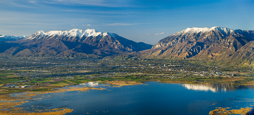
Utah County — the Provo/Orem region surrounding Utah Lake — is home to some of the most dramatic mountain peaks in the Wasatch Range. While neighboring Salt Lake County gets more press, Utah County holds both Mount Timpanogos (the iconic 11,752 ft Wasatch landmark) and Mount Nebo (11,928 ft — the entire Wasatch Range’s highest peak). This ranked list covers ten Utah County peaks ordered by overall hiking experience — weighing scenic reward, technical interest, accessibility, iconic status, and fitness challenge. Many of these summits form the legendary Wasatch 7 Peaks challenge, a local hiking tradition that’s become the unofficial graduation ceremony for Utah Valley hikers.
Ranking weighs five factors: scenic reward (summit views and trail aesthetics), technical interest (scrambling variety and route-finding), accessibility (drive time from Utah Valley and trailhead logistics), iconic status (local reputation and “Wasatch 7 Peaks” inclusion), and fitness challenge balance. Elevation data verified against US Geological Survey topographic records and Wikipedia’s Utah peak list. Trail statistics confirmed against Uinta-Wasatch-Cache National Forest management records. Geographic note: Mount Nebo sits at the Utah-Juab County line — Wikipedia designates it Utah County’s highest point while acknowledging it’s geographically shared with Juab County. We include it here per the prevailing Wasatch 7 Peaks convention. Geographic boundaries otherwise follow Utah County limits — see our Salt Lake County peak guide for northern Wasatch peaks. Reviewed by Utah Valley hiking community members. Fact-check date: April 19, 2026.
The Wasatch 7 Peaks: Utah Valley’s Local Challenge
The Wasatch 7 Peaks Challenge
Seven iconic summits visible from Utah Valley — an informal local hiking tradition tracked by community, Strava, and Instagram rather than any official organization. Most attempt the challenge across a summer season; ambitious hikers have completed all seven in 3 days. Approximately 80 miles total with 31,000+ feet of elevation gain.
The Wasatch 7 Peaks represent the spine of Utah Valley hiking — but they’re not the only peaks worth doing. The top-10 ranked list below includes these seven alongside three additional summits that deserve recognition. Work through the ranked list systematically and you’ll have experienced the full range of what Utah County’s mountains offer.
Before the List: How to Use This Ranking
This ranking follows a progressive journey from accessible to expert peaks. Peak #10 (Kyhv Peak) is the gateway — an approachable introduction to Utah County hiking. Peak #1 (Mount Nebo) is the ultimate Utah County achievement, the Wasatch Range’s highest summit requiring significant commitment.
How to work through the list
- First-time Utah Valley hikers: Start at #10 (Kyhv Peak). Build progressively.
- Experienced hikers: Jump in at #6-7 (Loafer/Spanish Fork) to match your fitness.
- Wasatch 7 Peaks aspirants: Seven of ten peaks here are part of that challenge.
- Peak baggers: Work on peaks you haven’t done, especially the top 3.
- Don’t skip ranks: Cascade Mountain (#3) or Mount Nebo (#1) as your first serious Utah County peak is a common dangerous mistake. Build up through 4-5 prior peaks.
Each peak profile includes ranked position, elevation, difficulty tier, stats, and why it earned its rank. Progress systematically for the full Utah Valley mountain experience.
The Ranking: Counting Down from 10 to 1
Kyhv Peak (formerly Squaw Peak)
Kyhv Peak (renamed from Squaw Peak in 2022 as part of cultural sensitivity updates) earns #10 by being the perfect introduction to Utah County mountain hiking. The short 3-mile round-trip with ~1,800 ft elevation gain fits into a weekend morning while still delivering legitimate Wasatch views over Utah Lake and Provo Valley.
Why we love it as a starter: the summit delivers panoramic views typically reserved for much longer hikes. Easy trailhead access on Kyhv Peak Road (formerly Squaw Peak Road) just up from Provo Canyon. Popular trail-running route for locals building fitness. Lower ranked only because it’s more of a foothill than a true Wasatch peak — essential foundation for everything else on this list.
Santaquin Peak
Santaquin Peak takes #9 for offering solid southern Wasatch hiking character as an approachable 10,000+ ft summit. Most hikers pair Santaquin with neighboring Loafer Mountain (#8) on a single day, making the pair a classic southern Utah County double-summit experience.
What distinguishes Santaquin: it’s the less-touristed alternative to the more famous Loafer — slightly quieter trails, similar terrain, solid southern Wasatch views including Mount Nebo’s southern profile visible across Juab Valley. The approach from the Loafer Mountain trailhead winds through aspen groves particularly stunning in October. Foundation peak for progressing hikers working toward harder southern Wasatch challenges.
Loafer Mountain
Loafer Mountain ranks #8 by being the more recognized of the Santaquin/Loafer pair. The summit is more defined, the trail slightly better maintained, and the local reputation more established. Many hikers do Santaquin en route to Loafer, creating a 12-mile day with both summits.
Why #8 and not lower: Loafer is part of the Wasatch 7 Peaks canon, making it a mandatory waypoint for challenge participants. The summit’s southern exposure delivers commanding views of Mount Nebo looming 1,200 ft higher to the south. Fall color displays in the aspen-lined approach are among Utah County’s finest. The Payson Canyon trailhead access is straightforward via Nebo Loop Scenic Byway.
Spanish Fork Peak
Spanish Fork Peak earns #7 for its challenging fitness profile — 5,138 feet of elevation gain across 9 miles makes it one of the steepest ascents in Utah County per mile. The trail passes through aspen groves, alpine meadows, and granite formations to a summit overlooking Spanish Fork Canyon and the Maple Mountain area.
What distinguishes Spanish Fork: the sustained grade demands real fitness without the technical challenge of higher-ranked peaks. Less trafficked than the more famous peaks on this list, delivering a genuine wilderness feel even on summer weekends. Classic southern Wasatch character with open alpine terrain. Great training peak for those preparing to tackle Mount Nebo or Timpanogos.
Box Elder Peak
Box Elder Peak ranks #6 as Utah County’s underappreciated 11,000+ ft summit. Located on the Alpine Loop directly north of Timpanogos, Box Elder offers similar elevation with a small fraction of the crowds. Access via Dry Creek Trail or Deer Creek approach from the Alpine Loop Scenic Byway.
Why Box Elder earns #6: the summit views of Timpanogos from the southwest are arguably better than Timp’s own summit views — you see Timpanogos as a massive whole rather than just being on it. Class 2 scrambling, solid ridge hiking, and an intimate feel even during peak summer. This peak rewards Utah County hikers who’ve progressed through the lower ranks and want 11,000 ft without Timpanogos’s crowds.
Provo Peak
Provo Peak takes #5 for being Utah County’s most intense short hike — only 3 miles round trip, but 2,677 feet of elevation gain creates the steepest grade on this list at nearly 1,800 ft per mile. Local reputation claims it’s “tougher than Timpanogos” — an overstatement in terms of total challenge, but absolutely true for pure grade intensity.
Why Provo Peak earns #5: the compressed difficulty delivers a different experience than long endurance peaks. Short enough to complete after work, steep enough to humble fit hikers, and the summit views from directly above Provo are spectacular. The trail is eroded and loose in places — trekking poles essential for descent. Access via Kyhv Peak Road from Provo Canyon. This is a “character-building” peak that teaches you about pure vertical effort.
Lone Peak
Lone Peak ranks #4 as the ultimate Utah County endurance challenge — 16 miles round trip with 5,810 ft elevation gain. The peak sits at the Salt Lake/Utah County border, claimed by both counties in hiking community discussions. Multiple approach options: Jacob’s Ladder (from Alpine), Cherry Canyon (Draper), or Lone Peak Cirque (Alpine Pass).
Why Lone Peak is #4: the combination of distance, elevation gain, and remote-feeling wilderness creates an expedition-level experience despite urban proximity. The Lone Peak Cirque approach delivers dramatic granite spires and alpine lake basins. Summit views encompass Salt Lake Valley, Utah Valley, and the central Wasatch. Typically 12-14 hours requires headlamp starts and significant endurance. This is often the “graduation peak” for Utah Valley hikers progressing from lower-ranked summits.
Cascade Mountain
Cascade Mountain earns the bronze medal at #3 despite being the lowest elevation in our top 5 — because this is consistently ranked as Utah County’s most difficult peak by local hikers. 12 miles with 5,174 ft gain, class 3 scrambling, multiple false summits, and terrain considered one of Utah’s most avalanche-prone.
Why Cascade ranks so high: the peak combines every Utah County challenge into one hike. Bridal Veil Falls (607 ft — tallest year-round waterfall in Utah) sits on its north face. The 2001 avalanche from Cascade destroyed the former aerial tramway, never rebuilt. The summit ridge demands sustained scrambling with exposure. Approach via Dry Fork Trail from Kyhv Peak Road (Rock Canyon Campground). Never attempt before July or after October due to avalanche conditions. Access to the trailhead requires 4WD or high-clearance vehicle for final 0.5 miles of rough dirt road.
Mount Timpanogos
Mount Timpanogos ranks #2 as the most iconic peak visible from Utah Valley — the massive ridgeline some describe as a “sleeping princess” dominates the skyline from Provo to American Fork. Second-highest peak in the Wasatch Range, Utah County’s signature summit, and mandatory for any serious Utah Valley hiker.
Why #2 and not #1: Mount Nebo is ~180 feet higher. Experientially, many hikers rank Timpanogos first — the mountain goats at Emerald Lake, the summit shelter tradition, the waterfalls on both trails, the Ice Cave remnants, the aspen groves. The Timpooneke Trail (14.3 miles) offers gradual grade with wildflower meadows; the Aspen Grove Trail (13.9 miles) passes Emerald Lake with steeper approach. See our complete Timpanogos challenge guide for full trail details, permit information, and preparation.
Mount Nebo
Mount Nebo ranks #1 as the highest peak in the entire Wasatch Range and the ultimate southern Wasatch achievement. Three connected summits (North at 11,928 ft, South at 11,882 ft, Middle between) create a dramatic knife-edge ridge traverse. Ultra-prominent peak with over 3,000 feet of topographic prominence.
Why Nebo earns #1: it’s the true high point of the Wasatch — higher than Timpanogos by 180 feet, higher than anything in Salt Lake County. The standard approach via the North Peak Trail from the Nebo Loop Scenic Byway starts at a relatively high 9,259 ft trailhead, making the 2,700 ft of elevation gain to North Peak summit shorter than many expect. The class 3 knife-edge ridge between the three summits is the defining feature — exposed, narrow, requiring composure but extraordinary. Solitude exceeds any other Utah County peak — many hikers see no other people all day. Access via Nebo Loop Scenic Byway (closed winter) from Payson or Nephi — 1 hour 45 minutes / 84 miles from Salt Lake City. Geographic note: Nebo sits at the Utah/Juab County line — often designated as Utah County’s highest point while geographically shared.
Honorable Mentions: Peaks That Nearly Made the List
Several Utah County peaks deserve recognition even though they didn’t earn a top-10 slot. These are worthwhile additions for hikers working through the list who want variety beyond the ranking:
East Provo Peak
Ridge peak accessible from Provo Peak via class 3 traverse. Part of the Cascade-to-Provo Peak ridge for advanced hikers completing Wasatch 11ers.
American Fork Twin Peaks
Straddles SLC/Utah County border. Higher than Timpanogos but geographically ambiguous — some rank it SLC County.
Mount Baldy (Alta)
Alpine Loop area. Ski-area accessible summit. Crosses between Utah County and Salt Lake County jurisdictions.
Shingle Mill Peak
On the Cascade-Provo Peak ridge. Accessible only via traverse, rarely done as standalone peak.
Freedom Peak
Another Cascade-Provo ridge peak. Class 3 scrambling from Shingle Mill toward East Provo. Experienced ridge hikers only.
Grotto Falls
Short family-friendly waterfall hike on Nebo Loop. Not a peak but a signature Utah County destination.
Top 10 Quick Comparison
| Rank | Peak | Elevation | Distance | Difficulty | Duration |
|---|---|---|---|---|---|
| 1 | Mount Nebo | 11,928 ft | 9.5 mi | Expert | 6-8 hrs |
| 2 | Mount Timpanogos | 11,752 ft | 14-15 mi | Expert | 8-11 hrs |
| 3 | Cascade Mountain | 10,908 ft | 12 mi | Expert | 8-11 hrs |
| 4 | Lone Peak | 11,253 ft | 16 mi | Expert | 12-14 hrs |
| 5 | Provo Peak | 11,068 ft | 3 mi | Expert | 4-6 hrs |
| 6 | Box Elder Peak | 11,101 ft | 7 mi | Strenuous | 6-8 hrs |
| 7 | Spanish Fork Peak | 10,192 ft | 9 mi | Strenuous | 8-10 hrs |
| 8 | Loafer Mountain | 10,687 ft | 12 mi | Moderate | 7-9 hrs |
| 9 | Santaquin Peak | 10,687 ft | 10 mi | Moderate | 6-8 hrs |
| 10 | Kyhv Peak | 7,870 ft | 3 mi | Beginner | 2-3 hrs |
The ranking represents skill and commitment progression. Starting with Cascade Mountain (#3) or Mount Nebo (#1) as your first Utah County peak is a common dangerous mistake — the sustained scrambling, altitude, and exposure require foundations built on lower-ranked peaks. Recommended progression: complete at least 3-4 peaks in tiers 10-6 before attempting expert-tier peaks (#1-5). Cascade specifically demands prior scrambling experience — the avalanche terrain and route-finding challenge have caused injuries and fatalities to unprepared hikers. See our mountaineering for beginners guide for systematic skill progression.
Utah County Hiking Logistics
Canyon and trailhead access
- American Fork Canyon (SR-92): $10 fee. Access Timpanogos, Box Elder, Alpine Loop peaks. Road closed Nov-May.
- Provo Canyon (US-189): Free. Access Kyhv Peak Road for Provo Peak, Cascade Mountain. Major US highway.
- Payson Canyon / Nebo Loop (SR-115): Free. Access Loafer, Santaquin, Mount Nebo trailheads. Scenic byway closed winter.
- Spanish Fork Canyon (US-6): Free. Access Spanish Fork Peak trails.
- Alpine Town Access: For Lone Peak approaches via Jacob’s Ladder.
Key safety considerations
- Avalanche awareness: Cascade Mountain is one of Utah’s most avalanche-prone peaks. Never attempt before July or after mid-October.
- Afternoon thunderstorms: Lightning above treeline kills hikers annually. Summit by 11 AM in summer.
- Wildlife: Mountain goats (especially on Timpanogos), mule deer, moose, mountain lions, black bears, rattlesnakes at lower elevations.
- Water scarcity: Most high peaks have no water sources. Carry 3-5 liters for full-day hikes.
- Cell coverage: Spotty throughout Utah County mountains. Download offline maps.
- Altitude: Utah Valley sits at 4,500 ft; peaks reach 11,928 ft. Sea-level visitors should arrive 1-2 days early.
- Road conditions: Kyhv Peak Road (Provo Peak, Cascade access) is rough dirt for upper sections — high-clearance recommended.
When to hike
- Lower peaks (Kyhv, Grotto): May through October, year-round for Kyhv with proper conditions.
- Mid-elevation peaks (Loafer, Santaquin, Spanish Fork): Late June through October.
- High peaks (Timpanogos, Nebo, Box Elder): Early July through early October. Snow lingers into mid-June.
- Cascade Mountain: July through October only — avalanche-prone outside this window.
- Lone Peak: Late June through September most reliable.
Utah County Peaks FAQ: Your Common Questions Answered
What is the highest peak in Utah County?
The highest peak in Utah County is Mount Nebo at 11,928 feet (3,637 m) — also the highest peak in the entire Wasatch Range. Mount Nebo details: (1) Elevation: 11,928 ft (North Peak, the higher of two summits; South Peak is 11,882 ft). (2) Prominence: Over 3,000 feet topographic prominence, qualifying as one of 128 ultra-prominent peaks in the United States. (3) Location: Southern Wasatch Range, accessible via Mount Nebo Scenic Byway from Payson or Nephi. Note: Mount Nebo is geographically at the Utah/Juab County line — Wikipedia and some sources designate it as Utah County’s highest point while noting it sits primarily in Juab County. (4) Distance: 8-9 miles round trip depending on trail choice. (5) Elevation gain: Approximately 3,600-5,400 feet depending on trailhead. (6) Duration: 6-8 hours for most hikers. (7) Technical rating: Class 3 on final ridge between three summits, knife-edge sections. (8) Difficulty: Expert-level due to length, elevation, and exposed ridge scrambling. Other iconic Utah County peaks by elevation: (9) American Fork Twin Peaks (11,433 ft) — straddles Salt Lake/Utah County border. (10) Mount Timpanogos (11,752 ft) — second-highest Wasatch peak, Utah County proper. (11) Lone Peak (11,253 ft) — also straddles SLC/Utah County border. (12) Box Elder Peak (11,101 ft) — Alpine Loop area. (13) Provo Peak (11,068 ft) — short but notably steep. (14) Cascade Mountain (10,908 ft) — directly above Orem/Provo. Mount Nebo holds the Wasatch Range’s elevation crown by approximately 179 feet over more-famous Mount Timpanogos.
What are the Wasatch 7 Peaks in Utah Valley?
The Wasatch 7 Peaks (also called the Utah Valley 7 Peaks) is an informal local hiking challenge covering seven iconic peaks visible from Utah Valley. The seven peaks: (1) Lone Peak (11,253 ft) — Ultimate northern challenge, 16 miles RT, 5,810 ft gain. (2) Mount Timpanogos (11,752 ft) — Iconic Utah County peak, 14-15 miles RT, 4,383 ft gain. (3) Cascade Mountain (10,908 ft) — Directly above Orem, approximately 12 miles RT, 5,174 ft gain. (4) Provo Peak (11,068 ft) — Short but steep, 3 miles RT, 2,677 ft gain. (5) Spanish Fork Peak (10,192 ft) — Southern Wasatch, 9 miles RT, 5,138 ft gain. (6) Loafer Mountain/Santaquin Peak (10,687 ft) — Often lumped together, 12 miles RT, 3,816 ft gain. (7) Mount Nebo (11,928 ft) — Ultimate finale, 9.5 miles RT, 3,872 ft gain. Total challenge statistics: (8) Approximately 80 miles combined mileage. (9) Approximately 31,000+ feet total elevation gain. (10) Typical completion: 7-14 days spread across summer season. (11) Extreme completion: Some ambitious hikers complete all 7 in 3 days. How the challenge works: (12) Not officially organized — informal Utah Valley hiking community tradition. (13) No registration or permits specific to the challenge. (14) Participants track progress via social media, Strava, personal journals. (15) Summer season (June-October) most common completion window. (16) Summer Saturdays popular attempt days. Recommended progression: Start with Provo Peak as introduction to Utah Valley peaks, work up through Spanish Fork Peak and Loafer, progress to Cascade and Timpanogos as major challenges, complete with Lone Peak and Mount Nebo. Individual peaks are excellent hikes even outside challenge context.
Is Cascade Mountain hard to hike?
Yes, Cascade Mountain is a challenging hike — one of the more demanding peaks in Utah County despite being only 10,908 feet. Difficulty details: (1) Distance: Approximately 12 miles round trip via the South Ridge (easiest route) from Dry Fork trail. (2) Elevation gain: Approximately 4,000-5,174 feet depending on route. (3) Summit: 10,908 feet elevation. (4) Duration: 8-11 hours typical. (5) Terrain: Forest switchbacks initially, then class 3 scrambling along ridge with multiple intermediate peaks to cross. (6) Exposure: Moderate to significant on ridge sections. Upper Pole Couloir route particularly intimidating. (7) Access: Kyhv Peak Road (formerly Squaw Peak Road) to Rock Canyon Campground, then rough dirt for ~0.5 miles. Why Cascade Mountain is demanding: (8) Extreme avalanche-prone terrain — 2001 avalanche destroyed former aerial tramway. Never attempt in winter or early spring. (9) Multiple false summits — long ridge with several bumps creates mental fatigue. (10) Loose rock — sections of talus and scree throughout ridge. (11) Exposed terrain — mostly open with intense sun exposure. (12) Limited water — carry 4+ liters for full day. (13) Reputation — many Utah County hikers consider it tougher than Timpanogos despite lower elevation. (14) Bridal Veil Falls signature peak — the 607 ft waterfall on Cascade’s north face is Utah’s tallest year-round waterfall. Access recommendations: (15) South Ridge from Dry Fork trail is easiest approach. (16) Upper Pole Couloir offers steeper but shorter alternative. (17) Big Springs Hollow east-side approach is longer but more scenic. (18) Ideal season: July through October when road fully open and trail snow-free. (19) Start time: No later than 6 AM in summer due to heat and thunderstorm exposure. Success rate: Approximately 55-65% of attempts reach the true summit. Many hikers stop at intermediate false summits, not realizing they’re not on the high point.
How do Utah County peaks rank by difficulty?
Utah County peaks span from short foothill hikes to multi-day expert expeditions. Difficulty ranking from easiest to hardest: Beginner-friendly: (1) Kyhv Peak (formerly Squaw Peak, ~7,870 ft) — 3 miles RT, ~1,800 ft gain, 2-3 hours. Accessible Provo foothill with valley views. (2) Grotto Falls Trail (Nebo Loop) — 0.6 miles RT, 200 ft gain. Short family-friendly waterfall hike. Moderate: (3) Provo Peak (11,068 ft) — 3 miles RT but 2,677 ft gain, 4-6 hours. Very steep, short but demanding. (4) Loafer Mountain/Santaquin Peak (10,687 ft) — 12 miles RT, 3,816 ft gain, 7-9 hours. (5) Box Elder Peak (11,101 ft) — 7 miles RT, 3,500 ft gain, 6-8 hours. Alpine Loop access. Strenuous: (6) Spanish Fork Peak (10,192 ft) — 9 miles RT, 5,138 ft gain, 8-10 hours. Southern Wasatch demanding. (7) Cascade Mountain (10,908 ft) — 12 miles RT, 5,174 ft gain, 8-11 hours. Class 3 ridge scrambling, avalanche terrain. Expert: (8) East Provo Peak (~11,100 ft) — Ridge approach from Provo Peak, class 3 traverse. (9) Mount Timpanogos (11,752 ft) — 14-15 miles RT, 4,383 ft gain, 8-11 hours. See our dedicated Timpanogos guide. (10) Mount Nebo (11,928 ft) — 9.5 miles RT, 3,872 ft gain, 6-8 hours. Knife-edge ridge between three summits. (11) Lone Peak (11,253 ft) — 16 miles RT, 5,810 ft gain, 12-14 hours. Ultimate Utah County commitment. Key difficulty factors: distance, elevation gain, technical scrambling, altitude effects, route-finding complexity. Provo Peak is interesting — short distance but extremely steep grade makes it harder than expected. Cascade Mountain and Lone Peak consistently rank as Utah County’s most demanding peaks among local hikers.
Where is Bridal Veil Falls in Utah?
Bridal Veil Falls is located on the north face of Cascade Mountain in Provo Canyon, Utah County — one of Utah’s most iconic waterfalls and the tallest year-round waterfall in the state at 607 feet. Bridal Veil Falls details: (1) Location: Provo Canyon, approximately 3 miles east of the canyon mouth on US-189. (2) Height: 607 feet (185 meters) across multiple cascades — the tallest year-round waterfall in Utah. (3) Type: Multi-tiered cascade fed by springs and snowmelt from Cascade Mountain. (4) Access: Free parking at Bridal Veil Falls State Park along US-189. Short paved path to base of falls. (5) Viewing: Walking paths provide multiple angles; best photography from across the Provo River. (6) Seasonal flow: Peak flow May-June from snowmelt; reduced flow late summer; ice formation in winter creating dramatic ice cones. Historical notes: (7) Aerial tramway history — From the 1960s until 1996, the world’s steepest aerial tramway ran 1,753 feet up the cliff beside the falls to a restaurant at the top. (8) Tramway destruction — A massive avalanche from Cascade Mountain on January 1, 1996 destroyed the tramway. It was never rebuilt. (9) Avalanche awareness — Cascade Mountain is one of Utah’s most avalanche-prone peaks. Large avalanches can reach canyon floor with 100+ feet of snow. Activity options: (10) Short family walks to the falls base. (11) Provo Canyon bike trail passes the falls. (12) Ice climbing in winter for experienced climbers. (13) Approach to Cascade Mountain summit — though the north face approach from the falls is not the recommended route. (14) Photography — especially with Cascade Mountain backdrop. Visiting tips: (15) Early morning best for photography and minimal crowds. (16) Winter visits offer dramatic ice formations. (17) Spring offers peak water flow. (18) Combine with Sundance Mountain Resort or other Provo Canyon attractions.
When is the best time to hike Utah County peaks?
The best time to hike Utah County peaks is mid-June through mid-October, with the sweet spot being August through September. Seasonal guide: (1) April-May: Lower peaks accessible (Kyhv Peak, lower Provo canyon trails) but high peaks have dangerous snow and avalanche conditions. Cascade Mountain specifically extremely dangerous in this window. (2) June: Snow melts off most peaks by mid-month. Wildflowers begin. Mount Timpanogos typically accessible mid-June. Cascade Mountain and Lone Peak still have lingering snow patches. (3) July: Peak hiking season begins in earnest. All Utah County peaks accessible. Hot valley temperatures — start before dawn. Afternoon thunderstorms frequent above 10,000 feet. (4) August: Prime conditions. Wildflowers transitioning, trails dry, days long. Still thunderstorm-prone afternoons. (5) September: Optimal month for most hikers. Cooler mornings, less thunderstorm activity, early autumn color beginning, 12+ hours of daylight. (6) October: Fall color spectacular, crisp air, fewest insects. Shorter daylight requires earlier starts. First snowfall possible late October. (7) November-May: Winter/snow conditions. SR-92 Alpine Loop closed. Nebo Loop Scenic Byway closed. Most peaks require mountaineering skills. Avalanche terrain on Cascade, Nebo, and most high peaks. Daily timing considerations: (8) Summer starts: 4:00-6:00 AM to beat heat and thunderstorms. (9) Cascade Mountain specifically: No later than 6:00 AM start recommended. (10) Mount Nebo: Dawn start ideal for daylight completion. (11) Provo Peak: Can do later start due to short distance. (12) Weekday advantages: Popular peaks (Timpanogos especially) much less crowded. (13) Sunrise summits: Popular for photographers on several peaks. Weather monitoring: (14) Check NOAA forecasts 24-48 hours ahead. (15) Utah Avalanche Center (utahavalanchecenter.org) critical for shoulder-season attempts. (16) Mountain-Forecast.com provides peak-specific predictions.
Can beginners hike Utah County peaks?
Yes, Utah County offers excellent beginner-appropriate peaks and trails, though most of the famous summits require significant preparation. Beginner-appropriate Utah County hikes: (1) Grotto Falls (Nebo Loop) — 0.6 miles RT, 200 ft gain, 30 minutes. Easy family waterfall hike. Excellent intro to Utah County mountain scenery. (2) Kyhv Peak (formerly Squaw Peak) — 3 miles RT, ~1,800 ft gain, 2-3 hours. Provo foothill with valley views. Solid first-peak experience. (3) Battle Creek Falls — 1.4 miles RT, 400 ft gain. Short waterfall hike near Pleasant Grove. (4) Stewart Falls — 3.5 miles RT, 700 ft gain. Popular Sundance-area waterfall hike. (5) Timpanogos Cave National Monument trail — 3 miles RT, 1,000 ft gain. Paved but steep trail to cave system. (6) Bridal Veil Falls — Very short walk from parking. Iconic waterfall viewing. (7) Rock Canyon trail — 4 miles RT, 1,200 ft gain. Provo area classic. (8) Cascade Springs — Boardwalk trail near Alpine Loop. Family-friendly. Beginner progression strategy: (9) Start with 1-2 mile hikes with under 500 ft gain. (10) Progress to 3-4 mile hikes with 1,000-1,500 ft gain (Kyhv Peak level). (11) Build to 6-8 mile hikes with 2,500-3,500 ft gain (start of serious peaks). (12) Save 10,000+ ft peaks for after 6+ months of regular hiking. (13) Mount Timpanogos is traditionally considered the ‘graduation hike’ for Utah County beginners — but only after significant training. Beginner safety tips: (14) Always hike with companion on first attempts. (15) Start early, set turnaround time regardless of summit proximity. (16) Carry water (2-3 liters even for short hikes), food, layers. (17) Check weather 24 hours ahead. (18) Tell someone your plan. (19) Cell coverage spotty on most peaks. See our mountaineering for beginners guide for systematic skill progression.
Is Provo Peak really harder than Timpanogos?
Provo Peak is not universally harder than Timpanogos, but the ‘tougher than Timp’ reputation has merit for specific reasons — mainly its extreme grade. Side-by-side comparison: Mount Timpanogos: (1) Elevation 11,752 ft. (2) Distance 14-15 miles RT. (3) Gain approximately 4,383 ft. (4) Duration 8-11 hours. (5) Grade average: ~500-650 ft/mile. (6) Technical: Non-technical hiking, some mild scrambling near summit. (7) Commitment: Long day, significant fitness. Provo Peak: (1) Elevation 11,068 ft. (2) Distance only 3 miles RT. (3) Gain 2,677 ft — but in just 1.5 miles up! (4) Duration 4-6 hours. (5) Grade average: 1,785 ft/mile — nearly 3x Timpanogos’s average. (6) Technical: Class 2 with some class 3 sections. (7) Commitment: Short but extremely intense. Why the ‘tougher than Timp’ reputation: (8) The grade is relentless — little rest throughout the ascent. (9) Trail is eroded and loose in sections, creating slipping hazards. (10) No water sources. (11) Can be surprisingly demanding mentally because you can see the summit from most of the ascent. (12) Descent on loose terrain is knee-punishing. Why Timpanogos is often still harder overall: (13) Total time on feet and total distance demand different endurance. (14) Altitude effect more pronounced at 11,752 ft vs. 11,068 ft. (15) Weather exposure: Longer exposure means more thunderstorm risk. (16) Mental fatigue from 10+ hour duration. Verdict: For pure grade intensity, Provo Peak is unquestionably steeper. For total endurance challenge, Timpanogos is generally harder. Many hikers do both — and their answer to ‘which is harder’ depends on whether they’re assessing intensity vs. endurance. See our Timpanogos challenge guide for comprehensive Timp information.
Authoritative Sources & Further Reading
Content reflects authoritative Utah sources and USGS data:
- Uinta-Wasatch-Cache National Forest — fs.usda.gov — Official trail management
- US Geological Survey — usgs.gov — Topographic data and peak elevations
- Utah County Visitors Bureau — utahvalley.com — Wasatch 7 Peaks documentation
- Mount Nebo Wilderness — Congressional designation
- Mount Timpanogos Wilderness — Congressional designation 1984
- Utah Avalanche Center — utahavalanchecenter.org — Winter conditions
- Utah Division of Wildlife Resources — wildlife.utah.gov — Wildlife safety
- Reference texts: Utah’s Wasatch Range: Four-Season Guide, Hiking Utah’s Wasatch, Road Trip Ryan and AllTrails trail data
Related Guides Across the Hub
Companion guides for Utah hiking, Japan, and broader mountain context.
Back to the Master Hub
This guide is one of 71 across 12 thematic clusters on Global Summit Guide. The master hub organizes every guide by experience tier, specific peak, skill area, and region.