<

Tag: Andes climbing

  • We summited Aconcagua in January. Here’s what no one tells you.

    We summited Aconcagua in January. Here’s what no one tells you.

    We Summited Aconcagua in January: Here’s What No One Tells You (2026) | Global Summit Guide
    Trip Reports / Aconcagua

    We summited Aconcagua in January. Here’s what no one tells you.

    6,961m
    Summit altitude
    21 days
    Expedition length
    4 of 4
    Team summit rate
    Jan 2024
    Climb date
    Part of the Master Guide This trip report is part of our comprehensive mountaineering reference. Browse all guides from one hub. Visit the Hub →

    Most Aconcagua trip reports skip the parts that actually matter. They tell you the days, the camps, the altitudes, and the summit photo. They don’t tell you how it felt to lie awake at 5,500m with a heart rate of 110 trying to catch your breath, or how the mules at Plaza de Mulas would walk through your tent vestibule at 4 a.m. looking for food, or how the Canaleta is one of the few places on a non-technical mountain where you genuinely think about whether you have the legs left to finish. This is a January 2024 expedition told the way it actually happened, with the parts most articles leave out. For the route comparison and broader 7-Summits decision context, our Aconcagua routes guide, our Seven Summits guide, and the master mountaineering hub set the broader frame.

    Why January

    The expedition booked for January 8-30, 2024. We picked January for the same reason most climbers do. December and January are the prime weather windows in the Argentine summer, and the upper-mountain temperatures are tolerable rather than vicious. The tradeoff is that you share Plaza de Mulas with 200 other climbers and the upper camps feel busy. We accepted that tradeoff. February is colder, March is essentially closed, and earlier than December the weather windows are unpredictable.

    Our team was four climbers and two guides. Two of us had been on Kilimanjaro the previous year, one had climbed Mont Blanc, and one had done Rainier and Hood multiple times. Reasonable preparation, no Everest veterans. The full background context for picking the second 7-Summit lives in our Kilimanjaro vs Aconcagua comparison.

    Mendoza, the permit, and the strange luxury before the climb

    Mendoza in January feels nothing like a high-altitude staging town. The full Mendoza guide-economy backstory lives in our Aconcagua Mendoza guide economy story. It’s hot, wine country, sidewalk cafés open until midnight, lined with sycamore trees. We spent two days there picking up our climbing permits at the provincial office (a one-hour bureaucratic slog), eating ribeye and Malbec, and adjusting to the time zone. The permit cost in 2024 was around 800 USD for the high season, paid in cash and in pesos at official exchange rates. By 2026 the figure has shifted with Argentina’s currency adjustments. Anyone reading this should verify the current high-season rate at the Mendoza tourism office before flying. The full pre-departure planning framework lives in our master mountaineering hub.

    The strange thing about Mendoza is that it lulls you. You forget you’re going to be cold for three weeks. You eat too much. You stay up too late. We had a guide who’d done Aconcagua 18 times tell us, on day two, to go home and sleep. He was right. That advice ranks among the most useful we got on the entire trip.

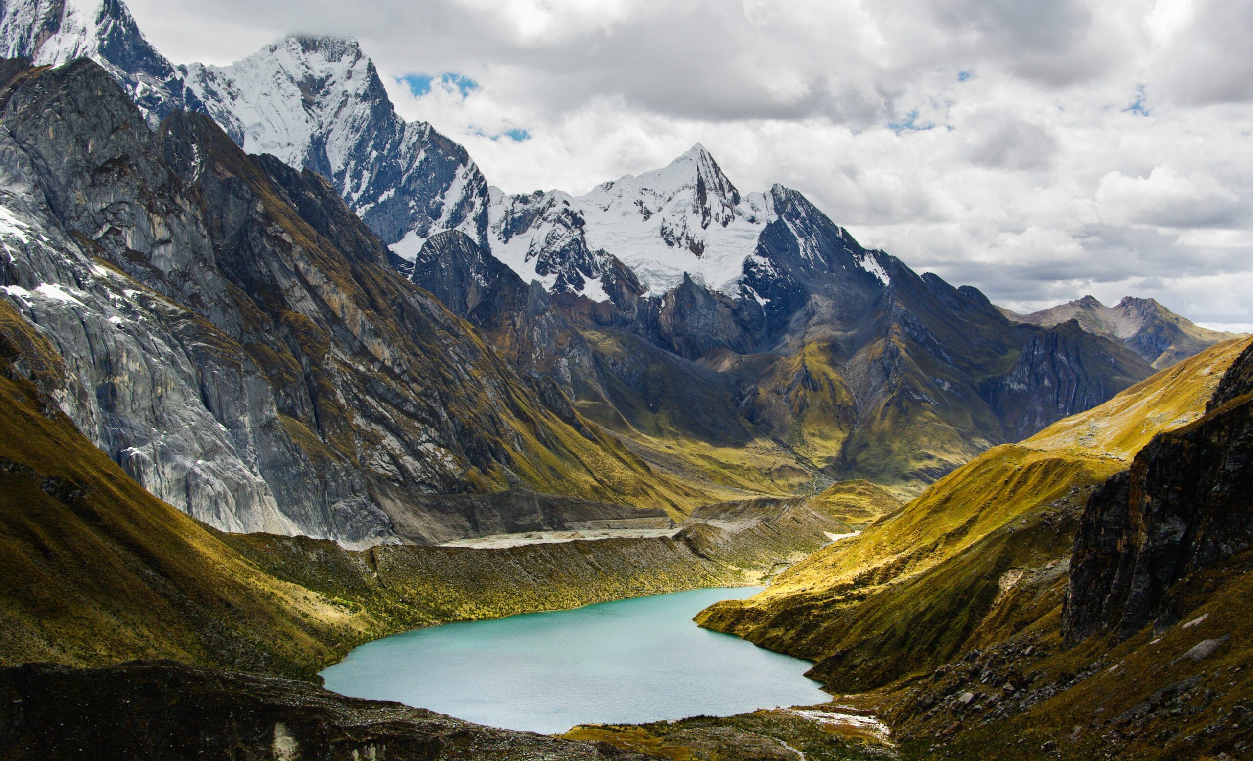
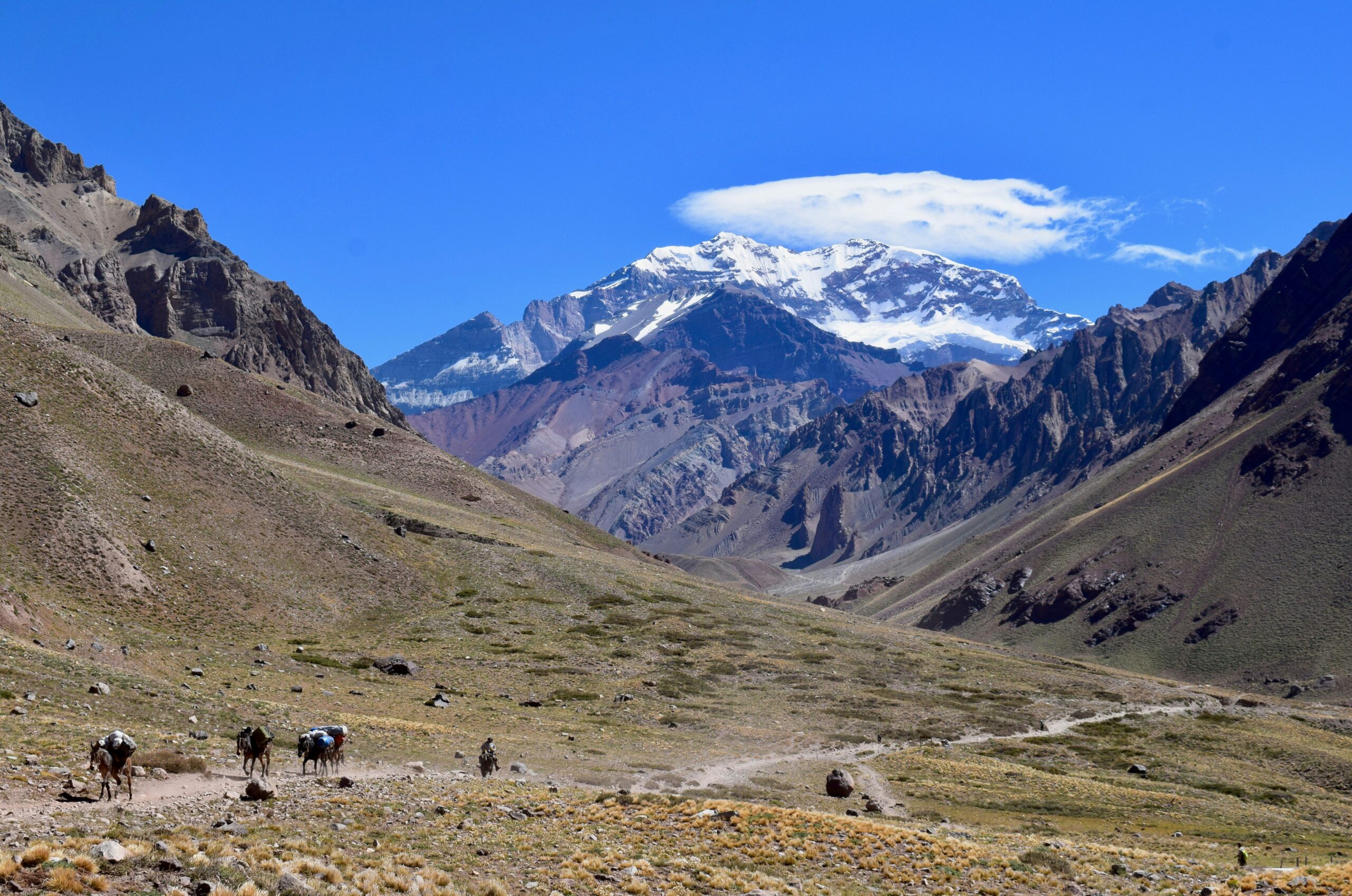
    The approach: Penitentes to Plaza de Mulas

    Day 03 · Approach

    Penitentes to Confluencia (3,400m)

    Start: 2,700mEnd: 3,400mDistance: 14 kmTime: 5 to 6 hr

    The bus drops you at Punta de Vacas. You shoulder a daypack, hand your duffels to the mule team, and start walking up the Horcones Valley. The first day is gentle. Wide open valley, the Vacas River alongside the trail, occasional llamas grazing in the distance. We reached Confluencia camp by mid-afternoon and pitched tents in the operator’s allocated zone. There’s a permanent ranger station here. They check your permit, check your insurance, and ask how you’re feeling.

    The acclimatization day at Confluencia is non-negotiable. We did the standard hike up to Plaza Francia (4,200m) the next morning, returning to Confluencia to sleep. This is climb-high-sleep-low protocol applied early, and it pays off three weeks later when summit night is the only night above 6,000m.

    Day 05 · Approach

    Confluencia to Plaza de Mulas (4,300m)

    Start: 3,400mEnd: 4,300mDistance: 17 kmTime: 8 to 9 hr

    The long approach day. You walk for nine hours through a barren, rocky, increasingly thin-aired landscape, climbing roughly 900m of net elevation across switchbacks and boulder fields. Most of it is exposed to direct sun and the Andean wind. You arrive at Plaza de Mulas tired, dusty, and slightly headachy. This is where the expedition starts in earnest.

    Plaza de Mulas in season is essentially a small city. There are 8-12 operator camps, a permanent ranger station, a high-altitude medical post, communal dining tents, and at certain operators hot showers. The internet works most of the time. There is a small store where you can buy candy bars and Nesquik and lukewarm beer for prices that would horrify you at sea level. The mules walk freely through camp.

    The acclimatization rotations: where most climbs are won

    Day 06 · Rest at base

    First rest day at Plaza de Mulas

    Camp: Plaza de Mulas, 4,300mActivity: Rest, gear sort

    You have to resist the urge to do something. The brain wants to climb higher, faster. The body needs to adjust. We slept 11 hours, drank water until our cheeks hurt, ate everything the dining tent put in front of us, and did almost nothing physical. By evening the headaches that some of us had on arrival had faded. Pulse oximeter readings ranged 78-86% across the team, which is normal at this altitude.

    Day 07 · Acclim rotation 1

    Carry to Camp Canada (5,050m), descend to base

    Climb to: 5,050mSleep at: 4,300mLoad: 35 lb

    The first carry day. You take a 35-pound load up to Camp Canada, leave it cached, and descend back to Plaza de Mulas to sleep. Carry-high, sleep-low again. The full physiology of why this protocol works is in our altitude acclimatization explainer. The altitude hits at Camp Canada in a way it didn’t at Plaza de Mulas. Your breathing is fast. Your heart rate is high even when you stop. You think about whether you really need everything you packed. Spoiler: you don’t, and shaving 5 lb off your high-camp kit between Plaza de Mulas and the actual carry days is something experienced climbers do quietly while their first-time partners pack everything.

    Day 08 · Rest day

    Second rest at Plaza de Mulas

    You sleep, eat, and force water. The mules outside the tent are louder than you expect. The medical staff make their rounds and check pulse-ox readings. One person on our team had readings dropping into the low 70s and was placed on Diamox at higher dose. The medical infrastructure at Plaza de Mulas is genuinely good, run by experienced high-altitude doctors. Our altitude acclimatization explainer covers the physiology of why these rotation rest days matter so much.

    Day 09 · Move up

    Plaza de Mulas to Camp Canada (5,050m), sleep there

    Up to Camp Canada with the rest of our gear. This is the first night above 5,000m for the trip. Sleep was rough. Heart rates stayed elevated, breathing was light and frequent, and several team members reported the strange dreams that come with altitude. By morning everyone was functional but no one felt rested.

    Day 10 · Acclim rotation 2

    Carry to Nido de Cóndores (5,560m), return to Camp Canada

    Climb to: 5,560mSleep at: 5,050m

    The second carry day. Climbing 500m above Camp Canada, dropping the load at Nido de Cóndores, then descending. The route is straightforward terrain but the altitude is doing things to your body that you can feel. Headaches return mid-afternoon. Appetite continues to fade. Two team members had mild AMS symptoms that evening and dosed extra hydration with Diamox unchanged. Standard protocol. Detailed symptom progression sits in our altitude sickness guide.

    Day 11 · Move up

    Camp Canada to Nido de Cóndores (5,560m)

    Moving up with our remaining gear. We slept at Nido that night. The wind picked up around 6 p.m. and pushed past 50 mph by midnight. The tent walls hammered. Sleep was effectively zero. By 4 a.m. the wind dropped, and by 7 we were able to cook breakfast and reassess. Aconcagua weather doesn’t broadcast itself politely. It announces.

    Day 12 · Rest day

    Rest at Nido de Cóndores

    A rest day at 5,560m is not really a rest day. Your body is working at maximum just to maintain itself. We ate, drank, slept in fits, and waited for the next weather forecast from base camp radio check. The forecast called for a possible summit window in 3 days, with a marginal day in 5. Our guides started talking about contingencies.

    By day 12 you stop counting the days. You count the meters above sea level you can sleep at without your heart rate spiking. The mountain has become a series of breathing problems to solve.

    Day 13 · Move up

    Nido de Cóndores to Camp Cólera (5,970m)

    The push to high camp. Camp Cólera sits just below 6,000m and is the staging point for summit night. The terrain is straightforward but the altitude is brutal. Each step requires a deliberate breath. We carried lighter loads up, having cached at Nido, but everyone arrived spent. The wind at Cólera was constant, the temperatures had dropped past freezing during the day, and the night ahead was the coldest we’d faced.

    Day 14 · Rest before push

    Resting at Camp Cólera, summit attempt tomorrow

    The day before summit night. You can’t sleep, you can’t eat much, you can’t really do anything productive. You melt snow. You sort gear. You re-pack your summit pack four times. The forecast is now firmly green for tomorrow. Wind under 30 mph, temperatures of -25°C at the summit, light cloud expected by mid-afternoon. Our guides briefed us on the timeline and turn-around protocols. Wake up at 5 a.m., depart at 6, summit by 1-2 p.m., back at Cólera by 6 p.m. Anything outside that envelope and we descend.

    Summit day

    Day 15 · Summit attempt

    Camp Cólera to Aconcagua summit (6,961m), and back

    Start: 5,970mSummit: 6,961mTotal time: 12 hours

    The 5 a.m. wake-up was rougher than expected. Sleep was maybe 90 minutes total. The vestibule of the tent was glazed in ice. The water bottle next to the sleeping bag had partially frozen overnight despite being inside the tent. We boiled water for instant oatmeal nobody really wanted, drank as much as we could force down, and were on the trail by 6:10 a.m.

    The first three hours climb steady switchbacks above Cólera, gaining 400m to a feature called Independencia (6,400m), where there’s a wrecked emergency shelter. The wind here was around 25 mph, biting through every layer of the system covered in our layering systems for mountaineering guide. Hands cycled between cold and warm depending on whether they were buried in mittens or holding a trekking pole. We did not stop long. The traverse from Independencia to the base of the Canaleta is a long, rising, exposed slope above 6,500m. You can see the summit pyramid the entire time. It does not get visibly closer for what feels like an hour. Cold-injury risk at this altitude in this wind is real, and our frostbite prevention guide covers the specific signs to watch for.

    And then the Canaleta. The final 200m up Aconcagua is a steep gully of loose scree and snow, frequently described as the hardest hour of any of the 7 Summits’ standard routes. You take three steps, you slide back one. Your lungs are operating at 40% of their normal effective oxygen. The slope is around 35-40 degrees and your body weight is fighting you the whole way. Two members of the team shifted to a step-and-rest pattern: 10 steps, then breathe for 15 seconds. The guides did not. They moved at a pace that seemed inhuman. They were not fitter than us. They were just acclimatized differently and had done this 18 times.

    We summited at 1:42 p.m., behind schedule but inside the turn-around envelope. The summit itself is small. There’s a Catholic cross. There’s a worn metal box with summit register cards. The view across the Andes runs in every direction and is genuinely stunning, though by then the cognitive bandwidth to appreciate it is limited. We took photos. We hugged. We started down within 20 minutes because that’s the rule and because the team understood that the summit isn’t the goal. The descent is the goal.

    The descent of the Canaleta was almost as difficult as the ascent. Loose scree under tired legs, fading cognition, the body just wants to sit down. By the time we reached Cólera at 6:30 p.m., we’d been moving for 12 hours straight at altitude. We ate, drank, and crawled into sleeping bags. Whether we slept or not, no one is sure.

    The descent

    You descend Aconcagua fast once the summit is done. We went Cólera to Plaza de Mulas the next day, a 1,700m drop in five hours. Your body recovers visibly with each elevation step down. By the evening at base camp you can eat real food again. Plaza de Mulas to Penitentes the day after is another long walk but at lower altitude, and the bus to Mendoza puts you back in restaurants and beds within 36 hours of the summit. The whiplash from 6,961m to a sidewalk café is psychologically strange.

    What worked, what we’d change

    Looking back, three things worked. The acclimatization rotation profile was conservative and paid off. Every team member who summited had used carry-high-sleep-low protocols across all three rotations. The gear was right. Double boots, a good parka, mittens with hand warmers, and a -20°F bag let us function in summit-night cold that would have ended a lighter kit. Our gear breakdown lives in the complete climbing gear list, with detailed boot guidance in the mountaineering boots guide. And the team had honest conversations about turn-around criteria before the summit attempt, which made the actual day calmer than it could have been.

    What we’d change. Pack lighter for the upper mountain. We carried 5-7 lb more gear than necessary above Camp Canada and paid for it on summit day. The right pack-selection framework is laid out in our expedition pack guide, and our sleeping bags for altitude guide covers the bag rating tradeoffs that matter at Aconcagua high camps. Train more for the Canaleta specifically. The slog at the top was the section we were least prepared for, and the only training that simulates it is sustained uphill scree-work at altitude. And spend an extra rest day at Plaza de Mulas. We had a 2-day rest at base camp; we’d take 3 next time. The cumulative deficit of inadequate sleep at 4,300m amplified everything that came later. Detailed Aconcagua-specific training adjustments live in our high-altitude training program, and the master hub indexes related guides.

    The honest summary

    Aconcagua is the hardest non-technical climb most recreational mountaineers will ever do. It is not technically demanding the way Everest or Denali are. It is logistically demanding, weather-dependent, cold, and long. The summit success rate of 30-40% is not an accident. It reflects what the mountain actually requires. Anyone walking into an Aconcagua expedition expecting it to be a bigger Kilimanjaro is going to find themselves at Camp Cólera wondering what they got themselves into.

    That said, it is summittable. The single most common failure point for first-time Aconcagua climbers is detailed in our Camp 2 mistake guide, with cost reality in our Aconcagua cost breakdown. With the right preparation, the right operator, the right gear, and a willingness to turn around when conditions don’t cooperate, the success rate climbs to 50-60%. Our January 2024 expedition put 4 of 4 climbers on the summit. The mountain doesn’t owe you that, but the preparation puts the odds in the right place. The complete operator-selection and expedition-planning framework lives in the master mountaineering hub, with peak-specific costs in our complete mountain climbing costs reference.

    ★ Master Resource

    Plan your Aconcagua expedition with the full guide

    The complete reference covers operator selection, training timelines, gear lists, permit logistics, and the full 7-Summits progression framework all in one hub.

    Visit the Master Hub →

    Common questions about climbing Aconcagua

    Is January a good time to climb Aconcagua?

    January is the second-best month behind December. Days are long, temperatures at high camps run -10°C to -20°C rather than the -30°C of November or February shoulder weeks, and summit windows tend to come every 4-6 days. The tradeoff is crowding. Plaza de Mulas runs at full capacity in January, permit costs are at peak season rates, and the upper camps can feel busy. Climbers seeking quieter conditions go in late February, accepting colder weather and fewer summit windows.

    How long does an Aconcagua expedition take?

    A standard Normal Route expedition runs 18-21 days door-to-door. The breakdown looks like 2 days approach trek to Plaza de Mulas, 6-9 days of acclimatization rotations, 2-4 day weather window for the summit attempt, and 2 days descent and exit. Add 2-3 days on each side for Mendoza logistics and recovery. The trip rarely runs short. It often runs long when weather windows close.

    What’s the success rate on Aconcagua?

    Aconcagua’s overall summit success rate runs 30-40% across all climbers. Quality guided expeditions push that to 50-60%. Independent climbers without local support and previous high-altitude experience often see rates below 25%. The mountain’s success rate is a function of altitude exposure, weather windows, and the willingness to turn around when conditions don’t cooperate.

    What was the hardest part of the climb?

    Summit night, by a wide margin. The day starts around 5 a.m. at Camp Cólera (5,970m), runs roughly 9-12 hours of climbing in temperatures of -20°C to -30°C with wind, includes the steep Canaleta scree gully in the final 200m, and ends with a long descent in oxygen-starved exhaustion. The Canaleta itself is the section most climbers describe as the hardest single hour of any 7-Summits climb.

    Did you carry your own gear?

    Yes, above Plaza de Mulas. The mules carry duffels to base camp at 4,300m. Above that, climbers carry their own loads of 35-50 lb between camps in coordinated team rotations. Most climbers cache gear at Camp 1 or Camp 2 on a carry day, descend to a lower camp for an extra acclimatization night, then return to the higher camp the next day with the next load.

    What was the food like?

    At Plaza de Mulas, the operator dining tent serves three hot meals a day cooked by base camp staff. Pasta, rice, soups, fresh meat, vegetables, fresh bread. The food is a real morale boost. Above base camp, the food shifts to dehydrated meals, oatmeal, soups, instant noodles, candy bars, and whatever each climber packed for snacks. Appetite collapses above 5,500m.

    What gear made the biggest difference?

    Three items stood out. The double mountaineering boots (La Sportiva G2 Evo in our case) kept feet warm through summit night when single boots would have frozen. The expedition mittens with hand warmers were the only thing that prevented cold-injury risk on the Canaleta. The -20°F sleeping bag made the difference between sleeping at high camps and shivering through nights.

    Should I climb Aconcagua before or after Kilimanjaro?

    After. Kilimanjaro is the introduction to high-altitude climbing. Aconcagua is the test of whether your body works at expedition altitudes for 3 weeks at a time. Climbers who do Kilimanjaro first arrive at Aconcagua with the altitude tolerance already proven and the camp craft skills already developed.

  • Andes Expedition Planning: High-Altitude Logistics

    Andes Expedition Planning: High-Altitude Logistics

    Andes Expedition Planning: High-Altitude Logistics Complete Guide (2026) | Global Summit Guide
    Cluster 08 · Altitude, Training & Physiology · Updated April 2026

    Andes Expedition Planning: High-Altitude Logistics for South America

    Country-by-country logistics for Peru, Bolivia, Chile, and Argentina — staging cities, seasonal patterns, permit systems, iconic peaks from Aconcagua to Alpamayo, and how altitude strategy adapts to South America’s dry continental climate. Where Himalayan/Karakoram physiology principles meet distinctly Andean logistics.

    4
    Major
    countries
    6,961m
    Aconcagua
    high point
    2 / 2
    Climbing
    seasons
    $800–8K
    Expedition
    cost range
    Global Summit Guide A guide in Cluster 08 · Altitude, Training & Physiology View master hub →

    The Andes are the world’s longest continental mountain range — nearly 7,000 km from Venezuela to Patagonia — and they differ from Himalayan/Karakoram expeditions in ways that matter for planning. The climate is continental and dry rather than monsoonal. The highest peak (Aconcagua, 6,961 m) is lower than dozens of Himalayan objectives. The climbing seasons run opposite the Northern Hemisphere (austral summer Dec-Feb for southern Andes, dry season May-Aug for northern Andes). Infrastructure is generally more developed, with paved roads reaching many base camps and commercial operators well-established. This guide walks through country-by-country logistics, staging cities, iconic peaks, and Andes-specific acclimatization considerations. For the underlying altitude physiology, see our acclimatization science guide; for Aconcagua specifically, see our complete Aconcagua routes guide.

    How this guide was built

    Expedition logistics drawn from commercial operators including Aconcagua Provincial Park, Skyline Adventures (Peru), Bolivia Climbs, Condoriri Travel, and Alpine Ascents International published itineraries. Country-specific permit and seasonal information verified against official government sources: Argentina’s Provincia de Mendoza, Peru’s SERNANP, Bolivia’s SERNAP, Chile’s CONAF. Cultural guidance from ethnographic sources and local climbing communities. Cost data compiled from current commercial expedition pricing (2025-2026 season). Reviewed by IFMGA-certified guides with extensive Andes expedition experience across all four primary climbing countries. Fact-check date: April 19, 2026.

    What Makes the Andes Distinctive

    Climbers accustomed to Himalayan expeditions often discover that Andes strategy requires different thinking. The core differences:

    • Continental climate, not monsoonal. Andes weather is driven by Pacific moisture and continental high-pressure systems rather than Indian Ocean monsoons. This produces drier, more predictable conditions with shorter but more frequent weather windows.
    • Lower absolute ceiling. The highest Andean peak (Aconcagua, 6,961 m) is lower than dozens of Himalayan objectives. No 7,000 m+ or 8,000 m peaks exist in the Andes.
    • Better road infrastructure. Most Andean base camps can be reached by vehicle, with minimal trekking approaches. This shortens expeditions dramatically compared to Nepal or Pakistan.
    • Urban staging at altitude. Cities like Cusco (3,399 m) and La Paz (3,640 m) are permanent high-altitude populations, offering developed infrastructure at altitudes that would be base camps elsewhere.
    • Two opposite seasons. Southern Andes (Argentina, Chile) climb December-February. Northern Andes (Peru, Bolivia) climb May-August. Ecuador’s equatorial peaks climb in two shorter windows.
    • Lower costs. A complete Aconcagua commercial expedition can cost less than an Everest permit alone.
    The “compressed” Andes expedition

    A 6,000 m Andes expedition typically takes 2-4 weeks compared to 4-8 weeks for equivalent Himalayan objectives. Road access to base camps eliminates long approach treks. Staging at 3,000-3,600 m in urban environments (Cusco, La Paz) provides immediate altitude exposure with full infrastructure. The result is a more intense, compressed expedition experience — less time at altitude overall, faster ascent rates, more aggressive acclimatization schedules. This works because Andean peaks max out below 7,000 m, so the absolute altitude stress is lower even with faster ascent. Climbers need to understand: this isn’t easier, it’s different. The same physiological rules apply, just applied on a shorter timeline.


    The Four Major Andes Climbing Countries

    Each country offers distinct climbing opportunities, infrastructure levels, and expedition styles:

    Country
    Peru
    May–Aug
    Technical & Varied

    Cordillera Blanca & Beyond

    Peru is the technical climbing heart of the Andes, dominated by the Cordillera Blanca — a 200 km stretch of granite-and-ice peaks with Huascarán (6,768 m) as its high point. Huaraz serves as the gateway city, with Cordillera Huayhuash and Cordillera Vilcanota offering remote alternatives. Best suited to climbers seeking technical challenge rather than altitude prestige. Famous for Alpamayo’s razor-edge aesthetic — “most beautiful mountain in the world” — and affordable, accessible climbing culture.

    Huascarán · 6,768 m Alpamayo · 5,947 m Artesonraju · 6,025 m Chopicalqui · 6,354 m Pisco · 5,752 m
    Gateway CityHuaraz (3,052m)
    Peak SeasonJune-July
    Cost Range$800-4K
    Country
    Bolivia
    May–Sep
    High Altitude & Accessible

    Cordillera Real Glaciated Peaks

    Bolivia offers the most accessible high-altitude climbing in the Andes. La Paz (3,640 m) provides instant high-altitude staging, with multiple 6,000 m peaks reachable on single-day expeditions. Huayna Potosí has become the world’s most popular “entry-level 6,000 m” — 5-7 day expeditions suitable for fit trekkers with minimal technical experience. Illimani (6,438 m) looms over La Paz as the cultural icon. Best for climbers seeking altitude experience without extreme technical demand or logistical complexity.

    Illimani · 6,438 m Huayna Potosí · 6,088 m Sajama · 6,542 m Ancohuma · 6,430 m Condoriri · 5,648 m
    Gateway CityLa Paz (3,640m)
    Peak SeasonJuly-August
    Cost Range$200-3.5K
    Country
    Argentina
    Dec–Feb
    Aconcagua & Patagonia

    Highest Peak Outside Asia

    Argentina owns Aconcagua (6,961 m) — the highest peak outside Asia and one of the Seven Summits. Mendoza serves as the gateway with exceptional commercial infrastructure, well-established permit systems, and the most developed base camp services in South America. Argentina also shares Patagonia with Chile, hosting Cerro Torre, Fitz Roy, and other technical alpine objectives. Best for Seven Summit collectors pursuing Aconcagua, or for Patagonian alpinists. The normal Aconcagua route requires no technical climbing — altitude is the challenge.

    Aconcagua · 6,961 m Tupungato · 6,570 m Cerro Torre · 3,102 m Fitz Roy · 3,359 m Nevado Juncal · 6,110 m
    Gateway CityMendoza (770m)
    Peak SeasonJanuary
    Cost Range$1.5-8K
    Country
    Chile
    Dec–Mar
    Volcanoes & Desert Peaks

    Ojos del Salado & Patagonia

    Chile offers the world’s highest volcano (Ojos del Salado, 6,893 m) and some of South America’s most distinctive climbing — dry Atacama Desert peaks, volcanic summits, and shared Patagonian peaks with Argentina. The desert approach to Ojos del Salado crosses one of the driest places on Earth before reaching glaciated summit terrain. Santiago serves as the modern, cosmopolitan gateway with excellent infrastructure. Best for climbers seeking unusual environments — volcano summits, desert approaches, and dramatic Patagonian fjords.

    Ojos del Salado · 6,893 m Llullaillaco · 6,739 m Volcán San José · 5,856 m Monte San Valentín · 4,058 m
    Gateway CitySantiago (543m)
    Peak SeasonJanuary-February
    Cost Range$1.2-5K

    Staging Cities: Your Acclimatization Base

    Every Andes expedition depends on its staging city — the urban base where you arrive, acclimatize, organize logistics, and (often) return for rest between peaks. The key staging cities each have distinct characters:

    Peru

    Cusco

    3,399 m

    Former Incan capital, UNESCO heritage, and the region’s richest cultural staging environment. Good infrastructure, extensive tourism services, and 2-3 day acclimatization is standard. Access to Cordillera Vilcanota and Vilcabamba peaks, though Cordillera Blanca peaks use Huaraz instead.

    Acclim2-3 days
    AirportInt’l
    StrengthCulture
    Bolivia

    La Paz

    3,640 m

    Highest administrative capital in the world. Arrival means immediate altitude exposure at levels exceeding many Himalayan base camps. 3-5 day acclimatization recommended. Primary gateway to Cordillera Real — Illimani looms over the city. Developed climbing services but more chaotic than Cusco.

    Acclim3-5 days
    AirportInt’l
    StrengthAltitude
    Peru

    Huaraz

    3,052 m

    Dedicated climbing town — more focused on mountaineering than tourism. Gateway to Cordillera Blanca technical peaks. Strong local climbing community, specialized gear shops, and experienced local guides. 2-4 day acclimatization typical. Less glamorous than Cusco but better for serious climbers.

    Acclim2-4 days
    AirportDomestic
    StrengthClimbing
    Argentina

    Mendoza

    770 m

    Wine region and Aconcagua gateway. Low altitude means no pre-expedition acclimatization benefit — climbers must build altitude on the mountain itself. Exceptional commercial infrastructure for Aconcagua, extensive expedition company options, permit office centralized. 1-2 days for gear prep and briefings before transferring to trailhead.

    Acclim1-2 days prep
    AirportInt’l
    StrengthLogistics
    Chile

    Santiago

    543 m

    Modern cosmopolitan capital with excellent international connections. Primary transit point for Central Chilean peaks and Ojos del Salado expeditions. Low altitude, so acclimatization happens on the mountain. Strong service economy, high-quality medical facilities, and good gear availability.

    AcclimTransit only
    AirportInt’l
    StrengthServices
    Ecuador

    Quito

    2,850 m

    Equatorial capital at near-3,000 m. Ecuador’s volcanoes (Cotopaxi, Chimborazo) are reached from Quito on short expeditions. UNESCO heritage city. Equatorial climate means two shorter climbing seasons (Dec-Feb and Jun-Sep) rather than Peru/Bolivia’s extended dry season.

    Acclim2-3 days
    AirportInt’l
    StrengthVolcanoes

    Iconic Andean Peaks: A Climber’s Menu

    Andes climbing spans from accessible high-altitude introductions (Huayna Potosí, 5-7 day expedition) to elite technical objectives (Cerro Torre, big-wall alpinism). Here’s how the flagship peaks compare:

    PeakCountryHeightDurationDifficultyBest For
    AconcaguaArgentina6,961 m18-21 daysAltitude (non-technical)Seven Summits, highest outside Asia
    Ojos del SaladoChile/Arg6,893 m10-14 daysAltitude + desertWorld’s highest volcano
    HuascaránPeru6,768 m7-14 daysTechnical moderatePeru’s highest, glaciated
    SajamaBolivia6,542 m7-10 daysAltitude (non-technical)Bolivia’s highest, volcanic
    IllimaniBolivia6,438 m7-14 daysTechnical moderateCultural icon above La Paz
    ChopicalquiPeru6,354 m7-10 daysTechnical moderateBeautiful Cordillera Blanca peak
    Huayna PotosíBolivia6,088 m5-7 daysEasy (accessible)Beginner high-altitude
    ArtesonrajuPeru6,025 m7-10 daysTechnical hardParamount Pictures peak
    AlpamayoPeru5,947 m7-14 daysHighly technical“Most beautiful mountain”
    PiscoPeru5,752 m4-5 daysEasy (non-technical)Introduction to 5,000 m+

    Andes Acclimatization: Compressed Strategy

    Andean acclimatization follows the same physiology as any altitude work (see our acclimatization science guide), but the logistics produce compressed strategies:

    Standard Andean approach

    1. Arrive at staging city (3,000-3,700 m for northern Andes). 2-3 days rest with light activity.
    2. Day hikes from staging city to 4,000-4,500 m without sleeping high. Classic climb-high-sleep-low.
    3. Warm-up peak — climb a 5,000-5,500 m peak (Pisco in Peru, Condoriri or Huayna Potosí in Bolivia) over 3-4 days.
    4. Return to staging city for 2-3 days recovery.
    5. Main objective — proceed to target peak with 1-3 camps.
    6. Descent and return — generally 1-2 days from summit to urban staging.

    Diamox usage is more common in Andes

    Because Andean expeditions compress the altitude timeline, acetazolamide (Diamox) prophylaxis is more common than on Himalayan expeditions. Typical dosing: 125 mg twice daily starting 1-2 days before altitude gain, continuing until well-acclimatized. This isn’t strictly necessary for everyone but is standard practice on guided Andean expeditions where schedules don’t allow extended natural acclimatization.

    Altitude risks specific to Andes

    • Rapid ascent rates — getting from sea level (Lima, Buenos Aires) to 3,500+ m in a day via commercial flight, followed by quick movement to higher altitudes.
    • Permanent residents misleading — locals in Cusco or La Paz are born adapted. Tourists arriving to live their normal pace at 3,600 m often develop AMS.
    • Desert dehydration — Atacama Desert and arid Andean approaches mean rapid fluid loss. Water discipline matters more than in wetter Himalaya.
    • Compressed schedules — commercial itineraries often push pace harder than Himalayan equivalents. Consider extending independently.
    Don’t let the “easier” reputation fool you

    Because Andes peaks are shorter and logistics simpler, climbers sometimes treat them as less serious. This causes real problems. Aconcagua’s summit success rate is 30-40% despite being “non-technical” — altitude kills motivation, motivation kills summits. HAPE and HACE still happen on Andean peaks, particularly on compressed schedules. Individuals still die on Aconcagua regularly, often from missed altitude illness signs. The mountain’s reputation as “accessible” doesn’t make its physiology gentler. Apply all the altitude principles from our altitude sickness guide — they work the same way at 6,500 m in Argentina as they do at 6,500 m in Nepal.


    Andes Expedition FAQ: Your Common Questions Answered

    What makes the Andes different from the Himalaya for climbing?

    The Andes differ significantly from the Himalaya in climate, altitude profile, infrastructure, and expedition style — Andean peaks feature drier continental weather, generally lower absolute elevations (max 6,961 m vs 8,849 m), austral summer climbing season, and more accessible logistics than remote Himalayan peaks. Climate differences: Andes continental climate drier more predictable, Himalaya monsoonal wet seasons extreme variability, Andean winds consistent from west (Pacific), Himalayan weather driven by monsoon patterns, Andean temperatures generally milder at equivalent altitudes, snow conditions more reliable in Andes, rain less common during climbing season. Altitude profile differences: Andes peak Aconcagua 6,961 m, Himalaya peaks 8,850 m (Everest), Andean 6,000m peaks abundant, Himalayan 7,000m+ peaks common, Andes starts lower altitude, less progression time in Andes, shorter expedition durations typical. Seasonal differences: Andes November-March (austral summer), Himalaya April-June (pre-monsoon) or Sept-Nov, Andes peak season December-February, Himalaya peak season May or October, Andes drier weather windows, Himalaya weather more unpredictable. Infrastructure comparisons: Andes multiple developed countries, Himalaya remote Nepal Pakistan Tibet India, Andes good road access to many peaks, Himalaya long approaches common, Andes helicopter rescue more available, Himalaya limited rescue infrastructure, Andes urban staging areas, Himalaya remote staging points. Expedition style: Andes shorter expeditions (2-4 weeks typical), Himalaya longer expeditions (4-8 weeks), Andes self-supported more common, Himalaya porter-supported mostly, Andes more technical climbing per peak, Himalaya more altitude per peak. Cultural factors: Andes Spanish-speaking regions, Himalaya multiple languages, Andes Catholic/Incan cultural blend, Himalaya Buddhist/Hindu cultures, Andes tourism infrastructure developed, Himalaya developing tourism in some areas. Technical considerations: Andes volcanic peaks common, Himalaya granite and ice peaks, Andes steep snow/ice climbing typical, Himalaya mixed terrain variety, Andes shorter climbing durations, Himalaya longer summit days. Cost comparisons: Andes generally less expensive per peak, Himalaya higher costs for 8,000m peaks. Each mountain range has unique characteristics that affect climbing strategy. The Andes offer excellent opportunities for high-altitude climbers who want varied terrain, accessible logistics, and diverse peak options. See our altitude acclimatization guide.

    Which countries have the best Andes climbing?

    Peru, Bolivia, Chile, and Argentina each offer distinct Andes climbing opportunities — Peru’s Cordillera Blanca for technical peaks, Argentina for Aconcagua and commercial infrastructure, Bolivia for high-altitude glaciers, Chile for volcanic peaks and desert Andes. Peru Cordillera Blanca: technical climbing paradise, famous peaks Huascarán (6,768 m) Alpamayo (5,947 m) Artesonraju, access from Huaraz (3,052 m), expedition duration 2-4 weeks typical, climbing season May-August (dry season), cost moderate compared to other Andes, infrastructure well-developed for climbing, permits Huascarán National Park fees. Peru other ranges: Cordillera Huayhuash (more remote), Cordillera Vilcanota (technical), Cordillera Vilcabamba (Incan heritage), Cordillera Urubamba (accessible), individual peak characteristics. Argentina Aconcagua region: Aconcagua (6,961 m) highest peak outside Asia, access from Mendoza (770 m), Cerro Tupungato (6,570 m), Nevado Juncal (6,110 m), excellent commercial infrastructure, permit systems well-established, climbing season December-February. Argentina Patagonian Andes: Cerro Torre (3,102 m) technical, Fitz Roy range, Paine National Park, challenging weather, shorter climbing seasons. Bolivia Cordillera Real: Illimani (6,438 m) iconic peak, Huayna Potosí (6,088 m) popular, Ancohuma (6,430 m), access from La Paz (3,640 m), glaciated high-altitude climbing, climbing season May-September, cultural significance important. Bolivia other areas: Cordillera Apolobamba (remote), Sajama volcano (6,542 m), Tunari area, unique Bolivian cultural context. Chile Northern Andes: Atacama Desert peaks, Ojos del Salado (6,893 m) world’s highest volcano, Llullaillaco (6,739 m), Volcán San José (5,856 m), volcanic peaks abundant, dry stable weather, climbing season December-March. Chile Patagonian: Paine National Park, Monte San Valentín (4,058 m), Chilean fjords climbing, challenging weather, unique wilderness. Best country by objective: technical climbing Peru (Cordillera Blanca), high altitude Argentina (Aconcagua), commercial climbing Argentina, cost-conscious Peru or Bolivia. Each country offers unique experiences and climbing opportunities.

    What are the iconic Andes peaks to climb?

    The iconic Andes peaks span from Aconcagua (highest outside Asia) to Alpamayo (one of the world’s most beautiful), offering diverse technical challenges, altitudes, and cultural settings. Aconcagua (Argentina 6,961 m): highest peak in Western and Southern Hemispheres, Seven Summit peak, non-technical normal route, altitude main challenge, commercial infrastructure excellent, expedition duration 18-21 days, climbing season December-February, cost $3,000-8,000 commercial. Huascarán (Peru 6,768 m): highest peak in Peru, technical challenge moderate, Cordillera Blanca icon, access from Huaraz, climbing season May-August, expedition duration 7-14 days, multiple technical variations, challenging icefall sections. Ojos del Salado (Chile/Argentina 6,893 m): second highest Andes peak, world’s highest volcano, desert approach, technical elements moderate, altitude primary challenge, climbing season December-March. Alpamayo (Peru 5,947 m): ‘most beautiful mountain in world’ (UNESCO recognition), highly technical, pyramid-shaped summit, Class 5 climbing on main faces, climbing season May-August, advanced mountaineering required. Illimani (Bolivia 6,438 m): iconic Bolivian peak, views from La Paz, technical challenges moderate, glaciated route, climbing season May-September, cultural significance important. Huayna Potosí (Bolivia 6,088 m): popular beginner high-altitude peak, technical challenge minimal, access from La Paz, rapid acclimatization possible, climbing season May-September, expedition duration 5-7 days, excellent for first-time high altitude. Artesonraju (Peru 6,025 m): known as ‘Paramount mountain’ (film inspiration), technical climbing, beautiful pyramid form, Cordillera Blanca. Chopicalqui (Peru 6,354 m): beautiful Andean peak, technical challenges moderate, glaciated approach. Pisco (Peru 5,752 m): popular beginner peak, non-technical normal route, high altitude experience, access from Huaraz, 4-5 day expedition. Sajama (Bolivia 6,542 m): highest peak in Bolivia, volcanic peak, non-technical, remote location. Each peak offers unique experiences and challenges. See our Aconcagua routes guide.

    When is the best time for Andes climbing?

    Andes climbing seasons vary by latitude and country — Argentina/Chile climb in austral summer (December-February), while Peru/Bolivia climb in dry season (May-August). Southern Andes austral summer (December-February): peak climbing season, stable weather patterns, longer daylight hours, higher temperatures, reduced snowfall risk, most commercial expeditions. Specific Argentina timing: Aconcagua December-February prime, Tupungato December-February, Cerro Plomo December-January, Patagonian peaks December-February, expedition planning October-November departures. Chilean timing: Ojos del Salado December-March, Llullaillaco December-March, Volcán San José December-March, Atacama peaks December-March, Patagonian peaks November-February. Northern Andes dry season (May-August): peak climbing season, stable high pressure systems, clear skies predominate, snow consolidation, good weather windows, most technical climbs. Specific Peru timing: Cordillera Blanca May-August, Cordillera Huayhuash May-August, Huascarán June-July peak, Alpamayo June-August optimal, technical routes best mid-season. Bolivian timing: Cordillera Real May-September, Illimani May-September, Huayna Potosí May-September, Sajama May-September, Apolobamba range May-September. Ecuador (equatorial): December-February dry season, June-September second dry season, Cotopaxi both seasons good, Chimborazo both seasons good, equatorial weather less seasonal. Peak performance months: Argentina January (mid-summer), Chile January-February, Peru June-July (dry heart), Bolivia July-August (stable), Ecuador December-January. Individual peak optimal times: Aconcagua mid-December to mid-February, Ojos del Salado December-February, Huascarán June-July, Alpamayo June-July-August, Illimani June-July, Huayna Potosí June-July, Pisco June-August. Weather pattern considerations: Southern Hemisphere patterns jet stream affects peak weather El Niño/La Niña cycles Pacific moisture sources Andes rain shadow effects desert vs tropical boundaries. Successful Andes climbing depends heavily on choosing the right time of year.

    How do staging cities affect Andes acclimatization?

    Staging cities play a crucial role in Andes acclimatization, providing intermediate altitudes between sea level and peak elevations — the most important being Cusco (Peru 3,399m), La Paz (Bolivia 3,640m), Huaraz (Peru 3,052m), Mendoza (Argentina 770m), and Santiago (Chile 543m). Cusco Peru: ancient Incan capital, altitude starting point, expedition infrastructure, cultural immersion, 2-3 day acclimatization typical, guide networks extensive, equipment available, international airport. La Paz Bolivia: highest administrative capital, direct altitude exposure, 3-5 day acclimatization, cultural significance, comprehensive services, high-altitude experience, Bolivia’s climbing hub, international flights. Huaraz Peru: Cordillera Blanca gateway, technical climbing hub, 2-4 day acclimatization, specialized guides, climbing-focused town, multiple peak access, climbing community, local expertise. Mendoza Argentina: Aconcagua gateway, low altitude starting point, wine region, expedition companies, cultural experience, good infrastructure, business services, international access. Santiago Chile: central Chile climbing, low altitude start, modern infrastructure, diverse climbing options, urban cosmopolitan, services comprehensive, international airport, transit hub. Quito Ecuador: Ecuadorian capital, volcano country access, cultural blend, 2-3 day acclimatization, good services, variety of peaks. Cities by altitude gain approach: sea-level start cities Mendoza (Aconcagua trip) Santiago (Chilean peaks) Buenos Aires (transit), large altitude gain needed. Moderate altitude starts: Quito (Ecuador), Huaraz (Peru), direct mid-altitude exposure, good acclimatization start. High altitude starts: Cusco (Peru), La Paz (Bolivia), direct high-altitude exposure, quick acclimatization possible. Acclimatization strategies by city vary: Cusco approach 1 day rest after arrival short day hikes gradual altitude increase hydration emphasis altitude medication consideration. La Paz approach 2-3 days acclimatization short hikes around city gradually higher day trips altitude effects monitoring. Huaraz approach 2-3 days acclimatization short hikes near city valley exploration gradual altitude increase. Mendoza approach 1-2 days business/cultural pre-trip preparation equipment checks final arrangements low-altitude rest.

    What permits do you need for Andes climbing?

    Andes climbing permits vary significantly by country and peak, ranging from simple park entry fees to complex commercial climbing permits. Argentina permits — Aconcagua permits: required for all Aconcagua climbers, cost $800-1,200 USD (peak season), includes park entry rescue services waste management, available online or in Mendoza, climbing season availability, waste management fees mandatory, rescue insurance included. Other Argentine peaks: park entry fees vary, some require climbing registration, few peaks need formal permits, commercial expeditions handle paperwork, individual permits easier. Peru permits — national park fees: Huascarán National Park $25-35 USD, Cordillera Huayhuash $30-40 USD, other park fees $15-25 USD, Peruvian Alpine Club membership helpful. Climbing permits: most peaks no specific climbing permit, restricted areas special permits needed, commercial expeditions business permits, professional guides preferred. Bolivia permits: most peaks no formal permits, national park entry fees $5-15 USD, commercial permits for operators, individual climbers typically okay, local registration sometimes needed. Chile permits — Aconcagua side: Chilean permits for border areas, Aconcagua base camp access, park permits needed, commercial operators handle. Northern Chile peaks: Ojos del Salado Chilean permit required, park entry fees, border area considerations. Patagonian Chile: Paine National Park $20-30 USD, climbing permits for some areas. Commercial vs independent considerations: commercial expeditions permits typically included simpler paperwork higher costs overall experienced operators emergency response. Independent climbing self-acquired permits research required lower costs more logistics work better local contacts needed. Permit application process — timeline considerations 2-6 months ahead typical peak season early application commercial permits easier individual permits variable. Required documentation passport information insurance verification medical clearance sometimes experience documentation guide certifications. Insurance requirements: evacuation coverage mandatory most peaks, medical insurance required, climbing-specific coverage important, rescue services included some permits, emergency contact required. See our mountain climbing costs guide.

    How does Andes acclimatization differ from Himalayan?

    Andes acclimatization differs significantly from Himalayan due to altitude profiles, approach styles, climate patterns, and infrastructure — Andean climbers often start from lower elevations with faster ascent rates, while Himalayan climbers have more gradual progression but longer total expedition times. Altitude profile differences — Andes starting altitudes: sea level to moderate altitude common, Mendoza (770 m) Aconcagua start, Cusco (3,399 m) Peru peaks, La Paz (3,640 m) Bolivian peaks, quick altitude gain possible, less progressive approach. Himalayan starting altitudes: Katmandu (1,400 m) Nepal, Skardu (2,450 m) Pakistan, Lhasa (3,650 m) Tibet, gradual altitude progression, longer approach times, built-in acclimatization. Approach differences — Andes approaches: road access common, short trek times, vehicle support available, less porter dependency, urban staging, commercial infrastructure. Himalayan approaches: foot approaches predominant, multi-day treks common, porter support essential, remote staging points, limited road access, traditional expedition style. Expedition duration: Andes 2-4 weeks total compressed acclimatization shorter summit pushes faster recovery needed multiple peaks possible flexible scheduling. Himalayan 4-8 weeks typical extended acclimatization longer summit pushes gradual fitness building single-peak focus fixed schedules. Acclimatization strategies: Andes approach rapid altitude gain intensive day trips strategic staging medication often used shorter acclimatization peak-specific preparation. Himalayan approach gradual progression extended camp rotations long acclimatization periods natural progression longer recovery traditional patterns. Climate differences: Andes continental climate predominant drier conditions overall stable high pressure reliable weather patterns shorter weather windows temperature extremes. Himalayan monsoon-influenced weather wet seasons extreme complex weather systems long weather windows sometimes seasonal variations dramatic moisture patterns. Infrastructure impact: Andes medical facilities available communication infrastructure transportation access commercial support emergency response rescue capabilities. Himalayan limited medical access satellite communication needed remote locations porter-dependent logistics limited rescue expedition-style support. Oxygen and altitude drugs: Andes oxygen optional most peaks medications commonly used Diamox prevalent short-term use typical. Himalayan oxygen essential above 7,500m extended medication use specialized protocols long-term altitude drugs. Both ranges require excellent preparation and acclimatization understanding. See our altitude acclimatization guide.

    How much does an Andes expedition cost?

    Andes expedition costs vary significantly by country, peak, style, and duration — ranging from $2,000-8,000 for commercial programs to $800-3,000 for independent climbs. Commercial expeditions: Aconcagua (Argentina) $3,000-8,000, Cordillera Blanca peaks (Peru) $1,500-4,000, Illimani (Bolivia) $1,200-3,500, Ojos del Salado (Chile) $2,500-5,000, Huayna Potosí (Bolivia) $500-1,500. Independent expeditions: Aconcagua $1,500-3,500, Cordillera Blanca $800-2,500, Illimani $500-1,800, Ojos del Salado $1,200-3,000, Huayna Potosí $200-800. Major cost components — international travel: US to Andes $400-800, Europe to Andes $600-1,200, Asia to Andes $1,000-2,000, peak season premium, advance booking savings. Internal transportation: domestic flights $100-400, long-distance buses $20-80, private transfers $50-200, 4WD vehicle rentals $80-200/day, local transportation $10-50/day. Accommodation pre-expedition: budget hostels $10-30/night, mid-range hotels $40-80/night, luxury hotels $100-300/night, climbing lodges $30-100/night, apartment rentals $40-120/night. Guide services: IFMGA guides $200-500/day, local guides $100-300/day, group rates available, multi-day discounts, insurance costs included. Porter services: high-altitude porters $50-150/day, trekking porters $20-80/day, load limits vary, cultural considerations, fair wage importance. Equipment costs — rental options: climbing gear rental $20-50/day, specialized equipment $30-80/day, high-altitude boots $10-25/day, clothing systems $15-40/day. Purchase alternatives: complete equipment $3,000-8,000, selected rental items $500-1,500, local purchases $200-800, international shipping $200-500. Permits and fees: Argentina Aconcagua $800-1,200 peak season, Peru Huascarán $25-35, Bolivia park entries $5-15, Chile Ojos del Salado $50-100. Insurance requirements: basic travel insurance $50-200, climbing-specific $200-800, evacuation coverage $200-600, high-altitude coverage $300-1,000. Cost comparison by country — most affordable: Bolivia (lowest overall), Peru (moderate costs), Ecuador (moderate costs). Higher costs: Argentina (moderate-high), Chile (higher costs), specialized expeditions. Seasonal variations: peak season premium 20-40% higher costs, shoulder season savings 20-30% lower costs. Andes expeditions offer excellent value compared to other major mountain ranges. See our complete mountain climbing costs guide.


    Authoritative Sources & Further Reading

    Content reflects expedition practice and official government sources:

    • Aconcagua Provincial Park (Argentina) — Official permits and expedition protocols
    • SERNANP (Peru) — National protected areas and climbing permits
    • SERNAP (Bolivia) — National parks and protected areas
    • CONAF (Chile) — National forestry and parks service
    • Federación Argentina de Montañismo — Climbing registration and services
    • Peruvian Alpine Club — Member services and climbing resources
    • American Alpine Club — Andes expedition reports and history
    • Commercial operators: Alpine Ascents International, Skyline Adventures, Bolivia Climbs, Condoriri Travel, Aventuras Patagónicas
    • IFMGA-certified guides with multi-country Andes expedition experience
    • Reference texts: Aconcagua: A Climbing Guide (R.J. Secor); The Andes: A Trekker’s Guide (Kathy Jarvis); Classic Climbs of the Cordillera Blanca (Brad Johnson)
    Published: April 19, 2026
    Last updated: April 19, 2026
    Next review: July 2026
    Part of the Global Summit Guide

    Back to the Master Hub

    This guide is one of 70 across 12 thematic clusters on Global Summit Guide. The master hub organizes every guide by experience tier, specific peak, skill area, and region.

    View the Hub →
Language »