
Last updated July 18, 2026
Nanga Parbat route comparison: Diamir, Rupal & Rakhiot faces
The “Killer Mountain” has 12 documented routes across three radically different faces – but only one is a real commercial climb. Here they are side by side: the Diamir Face Kinshofer standard, the Rupal Face (the highest wall on earth, elite-only), and the historic, largely abandoned Rakhiot line where Hermann Buhl made the 1953 first ascent.
One commercial route, one elite wall, one museum piece.
For nearly every 2026 climber, Nanga Parbat means the Diamir Face Kinshofer Route – the 1962 line that carries all the commercial infrastructure (fixed ropes, operator base camps, Sherpa or Hunza support), sometimes swapped for the parallel Messner 1978 line when Kinshofer Wall rockfall forces operators off the standard wall. The Rupal Face – the highest wall on earth, climbed only about five times – is elite alpinism, not a booking. The Rakhiot Face, home to Buhl’s 1953 first ascent, is essentially abandoned.
So the “route choice” here is really a face choice, and for commercial climbers it collapses to one system. What it does not collapse is the risk: this is a Killer Mountain with a roughly 21% historical fatality rate, and even the standard line rewards no complacency.
Where it is
Gilgit-Baltistan, northern Pakistan – the westernmost 8,000er, standing alone at the western anchor of the Himalaya.
Find Hotels, Flights & Trips for the World’s Best Hiking Destinations
The Global Summit Guide Travel Shop on Expedia — curated for outdoor adventurers, mountaineers, and serious hikers. Patagonia to the Alps. Nepal to the Rockies. Curated lodging for every region we cover.
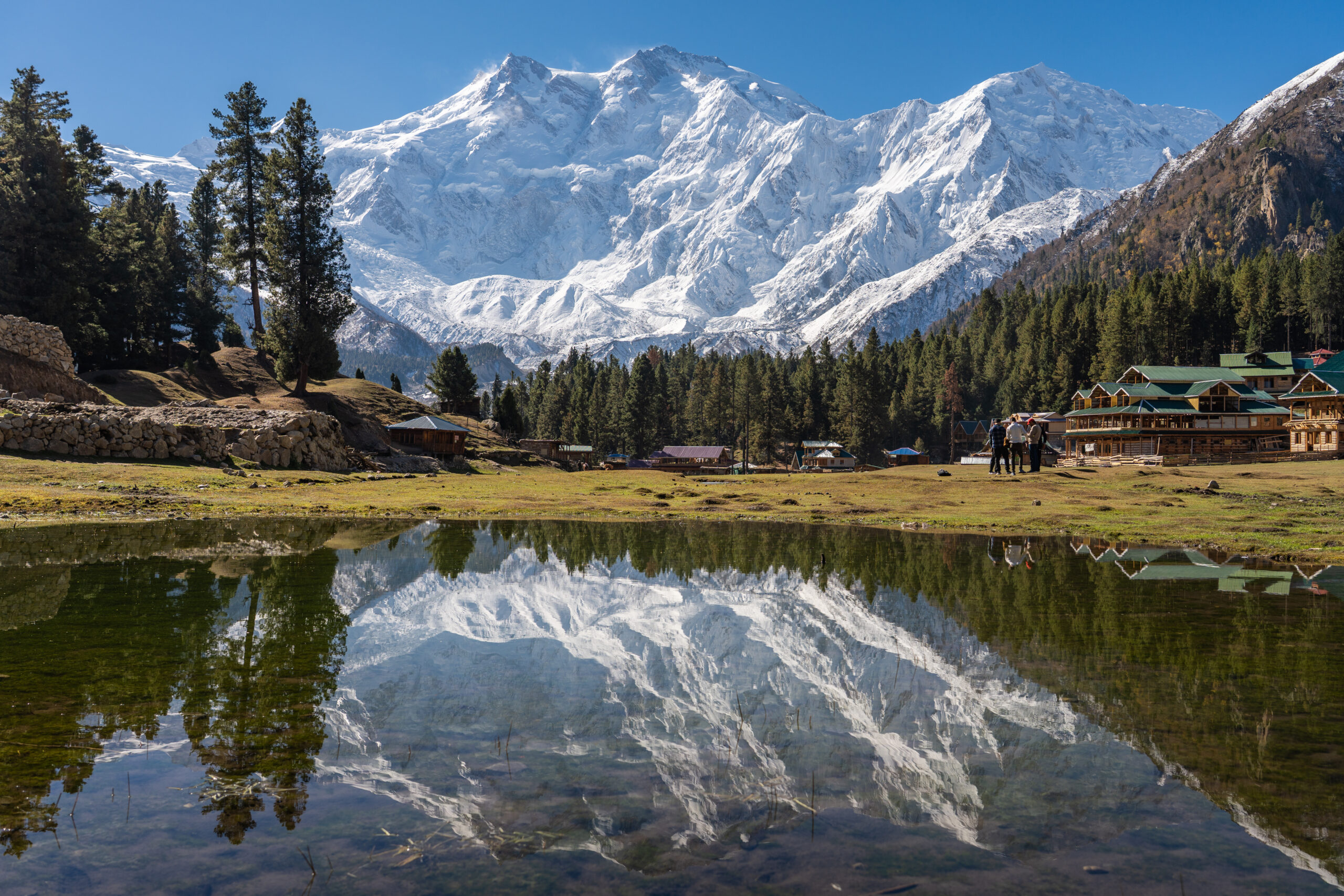
Explore Travel Shop on Expedia →Nanga Parbat (the “Naked Mountain,” from the Sanskrit; locally Diamer) is an 8,126 m (26,660 ft) peak in Gilgit-Baltistan, Pakistan – the ninth-highest mountain on Earth and the westernmost of the fourteen eight-thousanders, rising in isolation above the Indus. The commercial Diamir Face is reached from the Karakoram Highway via the Bunar Valley; the Rupal Face from Chilas and the Rupal Valley. See the full Nanga Parbat climb guide and how it ranks among the most dangerous mountains and the 14 eight-thousanders by difficulty.
The 3 faces
Three sides, three completely different climbs – and three different climbing communities.
Nanga Parbat’s geography produces three radically different faces, and they are not equally viable options – they are different sports. The Diamir Face is modern commercial climbing; the Rupal Face is elite alpine objective climbing; the Rakhiot Face is historic first-ascent climbing. For a 2026 expedition, the commercial path is nearly always the Diamir.
Diamir Face – the commercial standard
The Diamir is the only side with established commercial infrastructure – fixed-rope teams, multiple operator base camps, and Sherpa or Hunza guide support. Nearly all 2026 expeditions climb the Kinshofer Route, with operator-driven switches to alternative lines (chiefly the Messner 1978 line) when conditions demand. Its six documented routes include the Kinshofer (1962), the modern Kinshofer variant, the Messner Brothers descent (1970), Messner’s 1978 solo line, the Slovenian Route (2011), and minor variants.
Why commercial climbers choose Diamir
- Only face with commercial infrastructure and operators
- Shortest vertical from base camp to summit
- Established fixed ropes and route maintenance
- 60+ years of Kinshofer route knowledge
Persistent Diamir hazards
- Kinshofer Wall rockfall between Camps 1 and 2 (worsening)
- Weather instability at the upper camps
- Early-season avalanche risk on the lower glaciers
- Crowding pressure in summit windows
Rupal Face – the highest wall on earth
The Rupal is recognized as the highest wall on earth – about 4,600 vertical metres base to summit, exceeding the south faces of Annapurna I and Dhaulagiri. It has been climbed only around five times across all routes: the Messner Brothers SSE Spur (1970, first Rupal ascent), the Schell Route (1976), the South East Pillar (1982), Lafaille’s “Tom and Martina” (2003), and Schell variants. No operator runs Rupal programs – the technical demand, length, and objective hazard put it firmly in first-ascent-class alpinism.
Why elite alpinists target Rupal
- The highest wall on earth – a landmark achievement
- Multiple unrepeated variants for new-route climbing
- Pure alpine character, few climbers
- Shorter base-camp approach from Chilas
Why Rupal is not commercial
- No operator infrastructure or fixed ropes
- Technical demand beyond commercial clients
- ~5 ascents means minimal accumulated route knowledge
- No commercial guide support
Rakhiot Face – the 1953 first-ascent side
The Rakhiot is where Hermann Buhl made the mountain’s first ascent in 1953 – solo, without supplementary oxygen, after 31 climbers had already died trying. Its two routes are Buhl’s line (via the Rakhiot Glacier and East Ridge, over Rakhiot Peak at 7,070 m and through the Silberzacken “Silver Saddle” to the summit) and the 1996 Japanese Route. Both are essentially abandoned today: extreme avalanche risk on the glacier, long exposed upper ridge, and route length make them far less attractive than the Diamir Kinshofer. They keep their historical and cultural weight, but modern climbers overwhelmingly choose the Diamir.
The Kinshofer Route, section by section
The de facto standard – five sections from Diamir Base Camp (~4,000 m) to the 8,126 m summit.
Established as the mountain’s second-ascent line in 1962 by an Austrian team (Toni Kinshofer, Anderl Mannhardt, Sigi Low), the Kinshofer has become the practical default through six decades of route development and operator commitment. The modern line breaks into five climbing sections – and its continued rockfall problem is why operators actively manage it.
Base Camp to Camp 1 – glacier and lower slopes
Crossing the Diamir Glacier and climbing lower slopes to Camp 1 – basic crampon work, glacier rope-team travel, and fixed-rope on the steeper transitions. Used for acclimatization rotations; early-season avalanche risk is highest here.
Camp 1 to Camp 2 – the Kinshofer Wall (crux)
The defining section: a sustained steep wall of mixed rock and snow climbed on fixed ropes with jumars. This is the rockfall zone that pushed operators (Imagine Nepal and others) off the standard wall in 2022 onto an alternative near Messner’s 1978 line. Ask your operator about current-season status.
Camp 2 to Camp 3 – upper glacier plateau
Moderate-angle snow and ice on fixed ropes through the upper Diamir glacier system – the main high-altitude acclimatization zone, with multiple rotations before the summit push. Weather can force retreats to base camp for extended waits.
Camp 3 to Camp 4 – upper mountain setup
Steeper mixed snow, ice, and rock to the final pre-summit camp at ~7,300 m. Rest and oxygen use become the limiting factors; summit-day decision-making – weather, condition, oxygen reserves – typically begins here.
Camp 4 to summit and back – the Death Zone
A 10-14 hour round trip above 8,000 m, leaving around midnight up the upper Diamir ridge – exposed snow and ice with crevasse and rock-step hazards. The descent is the highest-fatality phase: the technical Wall waits at the end of an exhausting day.
Elite alpine routes
Reference points for the mountain’s climbing culture – not booking options.
Schell Route – Rupal Face
The most accessible Rupal line – via the Bazlin and Menge glaciers to the Mazeno Col, then the Upper Southwest Ridge. “Less technical” is relative on a wall climbed about five times; it is still far harder than the Kinshofer, and the elite alpinist’s usual introduction to the Rupal.
Messner Brothers South-South-East Spur – Rupal Face
The first ascent of the Rupal Face, ending in tragedy when Gunther Messner died on descent. A direct line up the south face to the summit ridge, 4,600 m of vertical, firmly elite territory – no commercial expedition has attempted it.
South East Pillar – Rupal Face
One of the most technically demanding routes ever climbed on Nanga Parbat, put up by Jerzy Kukuczka’s team – a sustained rock-and-ice pillar to the upper Southeast Ridge, with minimal repeat ascents. Significance is historical, not commercial.
Messner 1978 Route – Diamir Face variant
Messner’s solo line runs roughly parallel to the standard Kinshofer Wall and has gained new practical relevance: in 2022 operators fixed Camp 1 at 5,100 m along approximately this route to dodge Wall rockfall. Many modern climbers use it without realizing they are on the historic solo line.
Buhl Route – Rakhiot Face (historical reference)
The 1953 first-ascent line via the Rakhiot Glacier and East Ridge – one of climbing’s greatest feats, no longer climbed commercially because of avalanche risk, weather exposure, and length.
Mazeno Ridge – south-southwest (incomplete)
The longest ridge on any 8,000er, linking eight 7,000 m peaks. Every attempt has traversed the Mazeno Peaks but stopped short of continuing to Nanga Parbat’s main summit – the ultimate unfinished objective on the mountain.
Route comparison matrix
All the documented lines, by face, first ascent, 2026 status, and who they are for.
| Route | Face | First ascent | Status 2026 | Best for |
|---|---|---|---|---|
| Kinshofer Route | Diamir (W) | 1962 | Modern commercial standard | All commercial climbers |
| Messner 1978 Route | Diamir (W) | 1978 | Operator alternative to the Wall | When operators switch off Kinshofer |
| Slovenian Route | Diamir (W) | 2011 | Elite objective | Experienced alpinists |
| Messner Brothers descent | Diamir (W) | 1970 | Historical / rare | Historical reference |
| Schell Route | Rupal (S) | 1976 | Elite objective | Elite alpinists, “easier” Rupal |
| Messner Brothers SSE Spur | Rupal (S) | 1970 | Historical / elite repeats | First-ascent-class alpinism |
| South East Pillar | Rupal (S) | 1982 | Elite objective | First-ascent-class alpinism |
| Lafaille “Tom and Martina” | Rupal (S) | 2003 | Historical / unrepeated | Historical reference |
| Buhl Route | Rakhiot (N) | 1953 | Essentially abandoned | Historical reference |
| Japanese Route | Rakhiot (N) | 1996 | Essentially abandoned | Historical reference |
| Mazeno Ridge (incomplete) | SSW | Unclimbed in full | Attempted x5, never finished | The ultimate elite objective |
Which route is right for you
For almost everyone, the decision collapses to one face and one route system.
| Climber profile | Route | Reasoning |
|---|---|---|
| Commercial 8,000 m climber, first Nanga Parbat | Kinshofer (Diamir) | The only viable commercial option, with established operator support |
| Veteran 8,000 m climber, Nanga Parbat focus | Kinshofer / Messner 1978 | Route flexibility based on current-season Wall conditions |
| Elite alpinist, Rupal Face interest | Schell Route | The most accessible Rupal line – still elite-only |
| First-ascent-class climber | South East Pillar / Mazeno | Where new first-ascent lines are still possible |
| Historical research interest | Buhl Route (Rakhiot) | Not climbable commercially; a reference, not a booking |
Season & 2026 cost
A long Karakoram expedition with short, unreliable weather windows.
The season is June to August, with mid-July producing the highest concentration of summits. A standard commercial Kinshofer expedition runs 45-60 days from arrival in Pakistan through summit and descent – a few days in Islamabad, travel to Chilas or Gilgit, an approach trek up the Bunar Valley to Diamir Base Camp (~4,000 m), then 30-40 days of acclimatization rotations and a 5-7 day summit-window push. Build in buffer days: Karakoram windows are shorter and less reliable than the Nepal Himalaya, and teams sometimes wait weeks for a window that never opens.
| Item | Typical range | Notes |
|---|---|---|
| Commercial Kinshofer expedition (2026) | $25,000-50,000 USD | Seven Summit Treks, Imagine Nepal, Pioneer Adventure, Adventure Pakistan |
| Expedition length | 45-60 days | June-August; peak summits mid-July |
| Rupal / Rakhiot faces | No commercial programs | Elite alpine or historical only |
Planning a Nanga Parbat expedition?
Start with the full Nanga Parbat climb guide for permits and logistics, compare guides in the Nanga Parbat operators list, and carry comprehensive 8,000 m cover (insurance above 6,000 m). For flights into Islamabad and pre/post-expedition lodging, compare options through the Global Summit Guide Expedia travel shop.
Disclosure: the Expedia link is an affiliate link; we may earn a small commission at no extra cost to you, and it never affects our recommendations.
Nanga Parbat Climb Guide All Route ComparisonsNanga Parbat route FAQ
The questions climbers search most.
What is the easiest route?
The Kinshofer Route on the Diamir Face – the 1962 standard for nearly all commercial expeditions. Easiest is relative on a peak with a ~21% historical fatality rate: even the Kinshofer has persistent rockfall on the Wall between Camps 1 and 2 and weeks-long weather closures.
How many routes are there?
Twelve documented across three faces – Diamir (6, commercial), Rupal (4, elite), Rakhiot (2, historic). The Mazeno Ridge remains unclimbed in its entirety despite attempts in 1979, 1992, 1993, 1995, and 2004.
Diamir Face vs Rupal Face?
Opposite sides. Diamir (west) is the commercial side – ~4,100 m of vertical, fixed ropes, the Kinshofer. Rupal (south) is the highest wall on earth at ~4,600 m, climbed only ~5 times – elite alpinism with no commercial programs.
Why did Buhl climb the Rakhiot Face?
Pre-war German reconnaissance had marked the Rakhiot Glacier and East Ridge as the most viable line. Buhl summited solo, without oxygen, in 1953 after 31 climbers had died on the mountain. The route is abandoned today for avalanche risk, exposure, and length.
What is the Schell Route?
A 1976 Rupal Face line via the Bazlin and Menge glaciers to the Mazeno Col and the Upper Southwest Ridge. The most accessible Rupal route – but still elite-only and far harder than the Kinshofer.
Is the Kinshofer safe in 2026?
It is the safest route on the mountain, but not “safe” – ~21% historical fatality. Persistent Wall rockfall (operators switched off the standard Wall in 2022), weeks-long weather closures, and full altitude exposure. Its advantage is the commercial infrastructure the elite routes lack.
How long does it take?
About 45-60 days for a commercial Kinshofer expedition – Islamabad, travel to Chilas/Gilgit, approach to Diamir Base Camp (~4,000 m), 30-40 days of rotations, and a 5-7 day summit push. Season June-August, peak mid-July.
What is the highest wall on earth?
The Rupal Face of Nanga Parbat – about 4,600 vertical metres from base to summit, exceeding the south faces of Annapurna I and Dhaulagiri. Climbed only ~5 times; an elite objective, not a commercial climb.
How we built this comparison
- Built from American Alpine Journal route topos, SummitPost route documentation, ExplorersWeb expedition reporting (including the 2022 Imagine Nepal Kinshofer Wall switch), published climbing histories (Buhl 1953, Messner 1970 and 1978), and 2026 operator programs (Seven Summit Treks, Imagine Nepal, Pioneer Adventure, Adventure Pakistan), cross-checked for route status, season, and cost.
- The ~21% fatality rate is a historical estimate; route conditions (especially the Kinshofer Wall) shift in-season, so the standard commercial line is not a fixed, predictable route.
- The “12 routes” count reflects a common consolidation of major variants; some references count minor variants separately. The three-face structure and the commercial-vs-elite distinction matter more than the exact tally.
- Pakistan security in Gilgit-Baltistan is a real, changeable planning factor – verify current government travel advisories and operator security briefings before committing.
- Research-based, reviewed quarterly. Route review by Dawson Ludlow. Our team has not climbed this mountain.
Last updated: July 17, 2026 · Editor: Travis Ludlow · Route review: Dawson Ludlow. Verify current route status, operator pricing, and travel advisories before booking or climbing.
Confidence: Medium – three-face structure and route history stable; in-season Kinshofer routing and security status change.One mountain, three answers
For a 2026 commercial climb, Nanga Parbat is the Diamir Face Kinshofer – or the Messner 1978 line when the Wall closes. The Rupal is the highest wall on earth and elite-only; the Rakhiot is history. Whatever draws you, respect the Killer Mountain’s record and plan for the objective hazard on every line.
Nanga Parbat Climb Guide All Route ComparisonsWas this helpful?
🏔Related peaks nearby
🧭Explore & compare
Global Summit Guide is an independent mountaineering resource founded in 2026. The team combines first-hand trekking and climbing experience with in-depth research and professional health and nutrition review to help climbers choose objectives, prepare properly, and stay safe.
Health, altitude, and nutrition content is reviewed by Taylor Ludlow (Registered Nurse) and Brigg Hoopes (Nutritionist).
What We Don't Know Yet
Mountain information changes quickly. This box explains the limits of what this page can responsibly promise.
- Weather, snowpack, avalanche risk, road access, and route conditions can change quickly and may be different on your climbing dates.
- Route conditions, trailhead access, crevasse exposure, stream crossings, and rescue access may vary from published planning guidance.
- Fitness and altitude response vary by person; no guide, itinerary, or training plan can guarantee acclimatization or summit success.
- Comparisons simplify complex decisions; the better mountain depends on current conditions, skills, timing, budget, and risk tolerance.
Verify current conditions with official land managers, guide services, local forecasts, and current route reports before booking or climbing.
Part of this Global Summit Guide cluster
Explore the complete Mountains guide for more context, routes, planning links, and related resources.
Mountaineering, rock and ice climbing, glacier travel, and high-altitude activity are inherently dangerous and can result in serious injury or death. The information on Global Summit Guide is provided for general informational and educational purposes only and is not a substitute for professional instruction, qualified guiding, proper equipment, or your own judgment and experience.
Route conditions, weather, snowpack, permits, regulations, and hazards change constantly and may differ from what is described here. Details may be incomplete, out of date, or contain errors. Always verify current information with local authorities, certified guides, and official sources before making any decision in the mountains.
Nothing on this site is medical, legal, or financial advice. Our fitness, acclimatization, altitude, and nutrition content is general in nature; consult a qualified physician before beginning any strenuous exercise program or exposing yourself to high altitude.
You are solely responsible for your own safety and decisions. To the fullest extent permitted by law, Global Summit Guide and its team accept no liability for any loss, injury, damage, or expense arising from use of, or reliance on, this information. By using this site you acknowledge these risks and accept these terms.
Some links on this site may be affiliate links. If you buy through them we may earn a small commission at no extra cost to you; this never affects our recommendations.
Global Summit Guide recommendation path
Next Best Mountain to Research
Use these recommendations to continue the right planning path instead of stopping on one page.
Use current permit, weather, route, and operator information before booking or climbing.