
Kilimanjaro in 7 Days: A Complete Summit Diary on the Lemosho Route
What the 7-day Lemosho route actually feels like — from the first rainforest footsteps at Lemosho Glades to the dawn breaking over Uhuru Peak. Seven chapters covering every camp, every view, every moment that separates the operational guides from the lived experience of climbing Africa’s highest peak.
distance
ascent
reached
length
The planning guides tell you what Kilimanjaro demands — routes, costs, success rates, training plans, acclimatization math. This trip report tells you what Kilimanjaro is. Seven daily chapters from a 7-day Lemosho climb in February 2026 — the rainforest waking up on Day 1, the first dramatic view of Kibo on Day 3, the Barranco Wall scramble in morning mist, the 7-hour climb to Stella Point through darkness, the exact moment the sun broke over the Tanzanian plains while standing on Uhuru Peak. Not everything that happens on a mountain fits into a comparison table.
This report documents a 7-day Lemosho route climb completed in February 2026 with a KPAP-partnered operator. Group of 6 climbers (4 Americans, 2 Germans), 3 guides, 1 cook, 18 porters. Total cost per climber: $3,400 operator fee plus tips of $380. Fitness: moderate to strong; group summited 5 of 6 climbers on Uhuru. Report captures the sensory experience and daily rhythm that complements the operational guidance in our other Kilimanjaro Climbing Guide posts. Fact-check and editorial review: April 19, 2026.
The 7-Day Lemosho Itinerary at a Glance
Before the chapters, here’s the elevation and distance arc of the entire route — the bones of what the narrative flesh hangs on:
| Day | From → To | Elevation Gain | Distance | Hours |
|---|---|---|---|---|
| Day 1 | Londorossi Gate → Mti Mkubwa | 2,385 → 2,820 m | 7 km | 4–5 hrs |
| Day 2 | Mti Mkubwa → Shira 1 | 2,820 → 3,505 m | 8 km | 6–7 hrs |
| Day 3 | Shira 1 → Shira 2 | 3,505 → 3,900 m | 11 km | 6–7 hrs |
| Day 4 | Shira 2 → Lava Tower → Barranco | 3,900 → 4,630 → 3,940 m | 15 km | 7–8 hrs |
| Day 5 | Barranco → Karanga | 3,940 → 4,035 m | 5 km | 4–5 hrs |
| Day 6 | Karanga → Barafu → Uhuru → Mweka | 4,035 → 5,895 → 3,100 m | 22 km | 13–15 hrs |
| Day 7 | Mweka → Mweka Gate | 3,100 → 1,640 m | 10 km | 4–5 hrs |
The crucial pattern: the first three days are gentle ascent. Day 4 — the Lava Tower detour — is the first genuine altitude test. Day 5 is short by design (acclimatization). Day 6 is summit day and descent combined. Day 7 is the long descent through the final ecosystem zone back to warm air.
Day 1: Into the Rainforest
Londorossi Gate → Mti Mkubwa Camp
The morning begins with a three-hour drive from Moshi to Londorossi Gate, winding through Tanzanian countryside — coffee plantations, banana trees, villages with children waving at the safari trucks. The gate itself is anti-climactic: a weathered sign, registration clerks moving papers, dozens of porters organizing gear in the dust. Our operator leader introduces the crew — Emmanuel (head guide), Joseph and Ibrahim (assistants), and 18 porters whose names blur in the introductions. Everyone wears KPAP porter IDs on their shoulders.
From Londorossi we drive another hour further to Lemosho Glades at 2,385m — the actual trailhead. The rainforest here feels otherworldly. Thick canopy overhead. Moss-hung branches. Occasional colobus monkeys flashing black and white through the trees. It’s early afternoon when we start walking, packs adjusted, trekking poles extended, Emmanuel setting a deliberately slow pace that the fastest members of our group resist until he repeats pole pole for the fourth time.
The rainforest trail is gentle ascent — occasional muddy sections, roots, fallen branches. Birds call above us in species we can’t identify. A brief rainshower finds us at the 3-hour mark, reminding us to finally unpack rain jackets. The shower lasts 20 minutes, then sun cuts through the canopy in dramatic shafts. Porters pass us carrying impossible loads — 15kg balanced on heads, tents strapped across shoulders — and they’re all moving twice our speed while smiling and greeting us in Swahili.
Mti Mkubwa Camp (“Big Tree Camp”) appears through the forest just after 16:00 — tents already pitched by the porters who left Lemosho Glades 90 minutes after us. Our mess tent is set up with camping chairs and a table. Hot tea and popcorn appear as welcome gifts. The smell of cooking from the porter tent makes us instantly hungry. Dinner is soup, pasta, fresh vegetables that somehow survived the drive from Moshi, fresh fruit — the best meal we’ll eat on the entire mountain because everything after this is harder to transport and cook well.
After dinner, our first pulse oximeter check: everyone reads 94-97% oxygen saturation, normal at this modest altitude. By 20:00 we’re in sleeping bags, listening to night sounds of the rainforest — the occasional hyrax call, distant birds, wind moving through the canopy high above. Tomorrow we leave the forest forever until the descent.
- First time seeing “pole pole” actually written on a sign at the gate — the Kilimanjaro motto
- Watching a young porter balance a 15kg duffel on his head while hiking faster than we do with daypacks
- The smell of cooking fires mixing with rainforest humidity at Mti Mkubwa
- Emmanuel pronouncing our names in his accent — “Michael” becoming “MEE-kel”
- Realizing how dark true wilderness darkness actually gets
Day 2: Emerging from Forest
Mti Mkubwa → Shira 1 Camp
Wake-up is 06:00 with hot water delivered to our tents in metal bowls — washing water that somehow feels luxurious. Breakfast in the mess tent: porridge, eggs, toast, banana. Emmanuel briefs us on the day ahead — 7 hours of hiking, breaking through the treeline, first taste of the moorland zone. Most importantly: first altitude where some people start feeling effects.
The rainforest persists for the first 90 minutes. Then suddenly, dramatically, the trees end. One minute you’re under canopy; the next minute you’re in open landscape with giant heather bushes — plants that look like small trees until you realize they’re flowering heath. The trail climbs steadily through this transitional zone. The sky is enormous after the closed rainforest. We can see Mount Meru 80 kilometers to the southwest, its characteristic profile emerging from clouds.
By mid-morning we’re in classic moorland — giant lobelia plants rising two meters tall, looking like something out of science fiction. Senecio trees (giant groundsels) dot the landscape. The trail passes through tussock grasslands that remind me of Patagonia except warmer. Emmanuel points out wildlife tracks — buffalo have been here recently, he says. Occasional elephant tracks on the Lemosho route, though sightings are rare.
We stop for lunch at 11:30 — the porters have leap-frogged ahead and set up a lunch station with hot soup, sandwiches, fresh fruit. The food quality on day 2 is still excellent. Jackson, our cook, has figured out each of our dietary preferences already. Germans in our group request less spice; Americans want more coffee. Everyone gets accommodation.
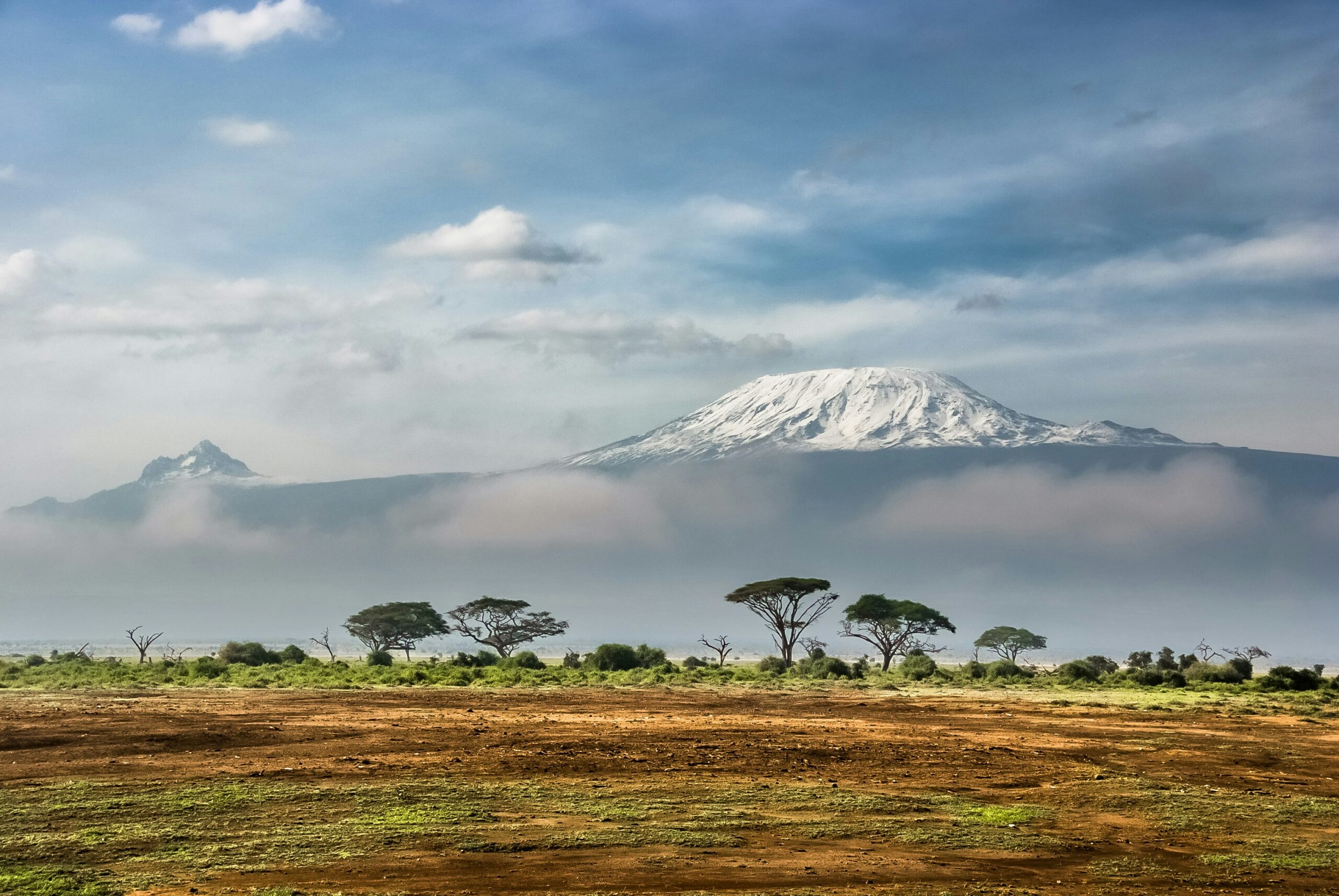
Shira 1 Camp sits on the eastern edge of the Shira Plateau at 3,505m. We arrive around 15:30 to tents already set up. The air feels different here — thinner, cleaner, cooler. Sunset views are spectacular: the entire Shira Plateau spread westward, Kibo’s summit visible to the east behind cloud layers. The mountain that seemed abstract in the rainforest is now unmistakably present.
One of our group — Rachel, 52, from Minnesota — develops a mild headache during dinner. Emmanuel reassures her it’s normal at this elevation and suggests extra water. Not everyone will have symptoms this early, but many do. She drinks three liters before bed and wakes up fine. Altitude revealing itself in small ways for the first time.
- Walking out of the rainforest into moorland — a literal border crossing in the landscape
- Seeing Mount Meru across the plains, 80km distant but clearly visible
- Giant lobelias standing taller than humans, otherworldly vegetation
- The sudden temperature drop when sun goes behind clouds at 3,500m
- First view of Kibo’s summit through cloud gaps at dinner
Day 3: Crossing the Shira Plateau
Shira 1 → Shira 2 Camp
Shira Plateau is a vast, windswept, mostly-flat expanse at nearly 3,500m, the bottom of what was once Kilimanjaro’s third volcanic cone (now collapsed). Walking across it feels like hiking on another planet. The ground is volcanic ash and rock. Vegetation is sparse and hardy. The plateau stretches for kilometers ahead with Kibo rising directly east, visible now in full glory through the clear morning air.
The trail gently climbs across the plateau rather than steeply ascending. This is deliberate — we’re gaining altitude slowly to allow acclimatization. Emmanuel stops regularly to point out specific plants: everlasting flowers (helichrysum) that bloom year-round in this climate. Senecio kilimanjari — the giant groundsel that only exists on Kilimanjaro and a few neighboring peaks. Protea kilimandscharica — endemic protea with massive pink flowers.
Mid-morning Rachel’s headache returns — mild but noticeable. Emmanuel pulls out the pulse oximeter: 88% oxygen saturation, normal for this altitude but approaching the lower range. He adjusts her pace, insists on more water, switches her snacks to include more salt. The Kilimanjaro guides are half medical team, half coaches. She rallies by lunch.
Lunch at Shira Cave (3,850m) — a natural formation where climbers have been resting for decades. Porters set up the lunch station with characteristic efficiency. Hot soup (cream of vegetable), sandwich wraps with hummus and vegetables, fruit, hot tea. At this altitude, hunger starts becoming variable. Some of us eat normally; two members of our group eat less than they’d like, appetite suppression being an early altitude symptom.
We arrive at Shira 2 Camp around 14:00. The camp is nestled at 3,900m with absolutely panoramic views. Kibo is now directly east and looking enormous — the glaciers visible even without binoculars, the summit crater visible against the sky. Sunset is spectacular: alpenglow turns Kibo’s snow-capped peaks golden, then pink, then deep red before the mountain fades into silhouette against twilight.
Dinner conversation focuses on tomorrow. Day 4 is the big one — climbing to Lava Tower at 4,630m for lunch, then descending to Barranco. This is the first true altitude test, the classic “climb high, sleep low” day that makes Lemosho successful. Emmanuel reviews symptoms to watch for. Everyone listens carefully. The mountain’s reality is starting to feel tangible.
Day 4: Lava Tower — The First Altitude Test
Shira 2 → Lava Tower → Barranco Camp
This is the day the mountain gets serious. The morning starts with a strong pace out of Shira 2, crossing increasingly barren alpine desert terrain — volcanic rock, sparse vegetation, thin air. The ascent is steady rather than steep, winding through a landscape that feels more like Mars than Africa. We can see our destination — Lava Tower — rising as a dark volcanic plug against the sky, perhaps four hours away.
The altitude starts affecting us noticeably now. Mild headaches appear in several members of the group. Breathing becomes conscious work — slower, deeper breaths than feels natural at sea level. Steven, the strongest athlete in our group, develops the worst symptoms of anyone — he’s pushing pace unconsciously despite Emmanuel’s repeated pole pole reminders. Fit climbers often suffer most on this day because they resist the required slow pace.
Three hours in we reach Lava Tower at 4,630m — a 300-foot volcanic spire where climbers rest for lunch. The air feels thin and I can feel my heart working harder just standing still. Emmanuel pulls out the pulse oximeter: readings across our group show 82-88% saturation. Three of us have minor headaches. One climber (Rachel) is nauseated and can barely eat. This is where altitude declares itself.
Lunch is simpler today by necessity — sandwiches, cookies, fruit, hot tea. No one eats much; appetite suppression is normal at this altitude. We rest for 90 minutes, letting our bodies taste 4,630m before descending. Emmanuel talks with each of us individually, gauging symptoms. He’s done this thousands of times and reads bodies better than they read themselves.
Then we descend — 700 vertical meters down to Barranco Camp at 3,940m. The descent on loose volcanic rock feels longer than expected. Our trekking poles earn their keep. The scenery changes dramatically as we drop — from bare alpine desert back into zones where senecio and lobelia can grow. The Great Barranco Valley opens before us, with the famous Barranco Wall visible ahead — tomorrow’s morning obstacle.
Barranco Camp is magical. We arrive at 16:00 with the sun setting directly behind the Barranco Wall, creating dramatic silhouettes against orange-red sky. The camp is the largest we’ve seen — perhaps 100 tents clustered on terraces built into the hillside. Climbers from Machame route converge here too, since Lemosho and Machame merge at Barranco. We meet climbers from a dozen countries. The international community sharing this experience creates instant camaraderie.
Headaches ease as we lose altitude. Rachel’s nausea resolves by dinner. Steven feels better but is quieter than usual — the altitude has humbled him. Pulse ox readings improve across the group. The climb-high-sleep-low principle is working exactly as designed — our bodies got a taste of 4,630m then retreat to a recovery altitude, and all night long they’re producing the adaptations we’ll need to summit.
- The strange quiet at Lava Tower — no birds, no insects, just wind
- Watching Steven (our strongest athlete) finally slow down when altitude humbled him
- Alpine flowers growing in cracks between lava rocks at 4,500m
- The Great Barranco Valley opening below as we descended — cinematic
- Meeting Kiwi climbers at Barranco who had just come down from Machame
Day 5: The Barranco Wall
Barranco → Barranco Wall → Karanga Camp
We wake early deliberately — starting the Barranco Wall at 07:00 rather than 09:00 means encountering fewer groups ahead of us on the wall. Looking up at the wall from camp is genuinely intimidating. It rises 257 meters in what appears to be a vertical face. From Barranco Camp it looks like something requiring ropes. Our fears are reinforced by sleepy pre-breakfast anxiety.
Breakfast is quick. By 07:15 we’re at the wall’s base, packs secured, trekking poles stowed (you need both hands free for parts of the scramble). Emmanuel leads, calling out which foot goes where, demonstrating holds and moves for the steeper sections. Behind us, a line of climbers from Barranco starts to form. We’re lucky to be ahead of the crowd.
The actual wall is dramatically less technical than it appears from below. It’s a Class 2-3 scramble — hiking with occasional hands-on moves. The steepest sections require three points of contact (two feet and one hand, or two hands and one foot). Most of it is simply steep hiking on rocky terrain. The exposure feels modest — there are plenty of ledges and gentle angles interspersed with the steeper bits.
The famous “Kissing Rock” is a specific passage where you hug a rock face to pass through a narrow section. Everyone photographs it. The moment becomes a shared joke — “who kissed the rock best?” — that persists through the rest of the climb. By 08:30 we’re at the top of the wall, 257 meters higher, with panoramic views down the Great Barranco Valley.
After the wall, the trail rolls through a series of valleys and ridges toward Karanga Camp. This is a deliberately short day — designed for rest, not distance. We arrive at Karanga (4,035m) around 11:30. Tents are barely set up; we wait for lunch. The afternoon is rest, journaling, conversations about tomorrow.
The group dynamic has solidified by now. We know each other’s stories — the Germans run a gardening business together; Rachel is a retired teacher celebrating 60 with this climb; Steven is training for Everest and using this as a warmup; Maria is climbing for her deceased mother who always wanted to see Kilimanjaro. Shared adversity creates fast friendships. We’ll stay in touch for years, exchange photos, some of us might climb together again.
Dinner at Karanga includes a specific briefing for tomorrow — summit day logistics. Emmanuel reviews the full 13-15 hour push ahead. We’ll reach Barafu (4,640m) tomorrow afternoon, rest until midnight, then begin the summit attempt. He describes Stella Point, the crater rim, the final walk to Uhuru. Everyone takes notes mentally. Sleep comes hard tonight — a mix of altitude, anticipation, and nerves.
Day 6: Summit Day — 15 Hours That Change You
Karanga → Barafu → Uhuru Peak → Mweka
The day starts at Karanga with a 4-hour walk to Barafu High Camp at 4,640m. The landscape is now genuinely alpine — volcanic rock, scree, almost no vegetation. We arrive at 12:30, eat lunch, then try to sleep from 14:00 to 22:30. Almost no one actually sleeps — anticipation is too high. I doze maybe 90 minutes total.
23:00 wake-up in darkness. Porridge, tea, biscuits that no one can finish. Full layering begins — the temperature at Barafu is already -5°C. Down jacket, hardshell, fleece pants, hardshell pants, mittens, balaclava. My pack is heavy with water, extra layers, camera, headlamp batteries. Pulse ox check shows everyone around 85-90% — acceptable for the push.
23:45: departure. We step out of Barafu into complete darkness with only headlamps and the first visible stars. Looking up the slope, a line of lights extends upward — other groups started earlier, their headlamps creating a dotted line reaching toward the sky. We join the procession, pole pole, one step at a time.
The first 2 hours (23:45-01:45) are steep scree. The trail switchbacks relentlessly upward. We walk slowly enough that talking isn’t possible — breathing is the only focus. The temperature drops as we climb. -10°C by 01:00. Then -12°C. Occasionally one of us stops to drink water from insulated bottles before continuing. No long rests — the cold would seize muscles. Emmanuel maintains unwavering pace.
By 03:00 we’re at about 5,200m and the altitude fully asserts itself. Every step requires conscious effort. Breathing feels shallow. My legs feel weighted. Psychologically this is the darkest hour — darkness outside, exhaustion inside, no sunrise yet visible. One of our group, Maria, starts vomiting from altitude. Emmanuel assesses her — she chooses to continue. Altitude affects people unpredictably. Some of our fittest members are suffering worst.
04:30: first hints of dawn. A faint light appears on the eastern horizon. The temperature feels its coldest — body heat low, sun not yet providing warmth. But hope enters as light grows. We can see the ridge above us for the first time. Stella Point is visible ahead, perhaps 45 minutes of climbing remaining.
05:15: Stella Point reached at 5,756m. On the crater rim for the first time. Hot tea from thermoses. Brief rest. Everyone can see Uhuru Peak now — the final 139 meters of elevation, perhaps 1 hour of walking along the rim. The sun is cresting the horizon now, painting the African plains in oranges and golds 80 kilometers below us. Mount Meru in silhouette to the southwest.
The walk from Stella to Uhuru is the emotional peak of the entire climb. Glaciers rise on our right — the shrinking Furtwängler glaciers, the remnants of a once-vast ice cap. The crater floor lies below us to the north. We can see other climbers ahead. Everyone is moving slowly but purposefully. Some are crying. The sun fully rises and temperature starts to moderate. The African plains stretch endlessly southward, cloudlayers visible below us.
06:20: Uhuru Peak reached. The famous wooden sign. “Congratulations! You are now at Uhuru Peak, 5,895m AMSL. Africa’s highest point.” Group hug. Photos with the sign. Maria — who was vomiting 3 hours ago — reaches the top smiling. Rachel (60-year-old retired teacher) summits. Steven (fast athlete) summits. The Germans summit. One of our group, Tom, has turned back at 5,500m due to severe altitude symptoms and is descending with Joseph. Five of six of us stand on the roof of Africa.
15 minutes at the summit. Emotional. Overwhelming. Too cold to stay longer. Then the descent begins — down to Barafu (3 hours on loose scree), then continuing to Mweka Camp (another 3-4 hours). By the time we reach Mweka at 3,100m, it’s 15:00. We’ve been active for 16 hours. I fall asleep during dinner at 19:30, head on the mess tent table. No one blames me.
- The line of headlamps ahead of us, extending upward like a string of pearls in the black sky
- Realizing at 3 AM that I hadn’t felt my toes for an hour
- The exact moment the sun crested the eastern horizon and I could see Kenya’s plains 80km away
- Rachel (60) reaching the summit with both hands in the air
- Maria vomiting at 5,400m, then summiting at 5,895m two hours later
- The Furtwängler glacier’s dying beauty — ice that won’t exist by 2050
- The crater floor visible below us, a lunar landscape of ash and snow
Day 7: The Long Descent
Mweka Camp → Mweka Gate
Wake-up at 07:00 — luxurious after yesterday’s 23:00 start. The camp feels festive. Everyone is slightly wrecked but buzzing with accomplishment. Jackson prepares a celebration breakfast with everything we’ve missed for a week — real eggs, pancakes, fresh fruit, bacon, coffee. We eat seriously for the first time in days.
Before departing, the crew gathers for the traditional tipping ceremony. We present envelopes by role — head guide, assistants, cook, porters — with small thank-you speeches. The crew responds with the Jambo Bwana song, a Swahili welcome-and-farewell song that porters sing at this ceremony across Kilimanjaro. Everyone is emotional. These people have carried our gear, cooked our food, monitored our health, and literally walked us to the summit. The tips — $380 per climber distributed — represent substantial income for them.
The descent begins. The trail drops steeply through moorland that transitions quickly into rainforest — ecosystems in reverse. By the second hour we’re back in thick canopy, tropical humidity, bird calls overhead. The temperature rises dramatically. Down jackets come off, then fleeces. By the end we’re in t-shirts sweating in rainforest warmth.
Mweka Gate appears at 13:00. A simple sign, a few vendors selling certificates and beer. We drop packs. Local guides and porters from our operator gather around a celebration table. Cold Kilimanjaro beer (brewed locally) appears. The German couple finally smiles broadly. Rachel calls her husband crying happily on a borrowed phone. Emmanuel distributes summit certificates — mine says “Climbed Successfully to Uhuru Peak, 5,895m, 15 February 2026.”
The 2-hour drive back to Moshi feels surreal. We pass villages we drove through a week ago without understanding where we were going. Now we’ve been there. Now we’ve been to the top. The hotel in Moshi feels like a palace after camping for 7 nights. Hot shower. Real bed. Dinner that doesn’t require porter delivery.
That evening, we sit on the hotel terrace watching Kilimanjaro’s summit in the distance. It seems impossible that we were up there 30 hours ago. The mountain rises above the town, summit clear against the evening sky. We order local beer and raise glasses. Emails exchanged. Instagram handles shared. Everyone promises to stay in touch.
Most don’t, over time. But every February 15 for years afterward, my phone buzzes with messages from 3 strangers I climbed with — “one year”, “two years”, “three years”. We remember exactly what we did. We remember what it cost and what it gave. Kilimanjaro stops being a mountain and becomes a verb — something we did. Something we’ll always have done.
- Jackson’s final breakfast — real eggs, pancakes, somehow tasting better than any restaurant
- The Jambo Bwana song at the tipping ceremony — porter voices in harmony
- Descending back into warm air and realizing how cold we’d been
- Emmanuel’s handshake at Mweka Gate, quiet and meaningful
- The first hot shower in Moshi — sitting on the floor laughing
- Watching Kilimanjaro from the hotel terrace and not recognizing myself in the person who had done that
What I’d Tell Future 7-Day Lemosho Climbers
After completing the route, several observations and recommendations emerge for anyone planning this climb:
- Train for the descent as much as the ascent. Summit day is 1,255m up then 2,730m down. My quads hurt worse from the descent than my lungs from the ascent. Single-leg strength work matters.
- Pole pole is not advice — it’s physics. Fit climbers suffered most because they resisted the required slow pace. Trust your guide’s pace from Day 1.
- Your boots will determine your comfort. Bring fully broken-in boots. I had zero blisters; one climber had 6 blisters by Day 3 because her boots were new.
- The Barranco Wall is easier than it looks. Don’t waste anxiety. It’s fun, photogenic, safe with guides, and over in 90 minutes.
- Summit day is exactly as hard as they say. 13-15 hours in the cold and dark is real. Mental preparation matters.
- KPAP-partnered operator was worth every dollar. Watching well-treated porters vs. exploited porters on neighboring operators — the ethical difference is visible on the mountain.
- Consider 8-day Lemosho instead of 7-day. We succeeded at 83% (5 of 6), but 8-day improves odds to 90-95%. The extra $200-400 is cheap insurance on a trip costing $5,000+.
- Bring a journal. These moments fade faster than expected. Write something each evening at camp. You’ll thank yourself later.
Yes — but next time I’d choose the 9-day Northern Circuit for its higher success rate and quieter trails. The 7-day Lemosho is achievable and memorable, but the extra days on longer routes dramatically reduce suffering on summit day while improving summit odds. If returning for Crater Camp or photography, I’d add time. Kilimanjaro is a mountain you can climb multiple times with different experiences each time. Some climbers return every few years. Now I understand why. See our duration guide for the full success-by-days breakdown.
Kilimanjaro Trip Report FAQ: Your Common Questions Answered
What does a 7-day Lemosho climb actually look like?
A 7-day Lemosho climb covers approximately 70 kilometers with 4,085 meters of elevation gain from start to summit, followed by 4,035 meters of descent. Day-by-day breakdown: (1) Day 1: Arrival at Londorossi Gate (2,385m), drive to Lemosho Glades, hike 4-5 hours through rainforest to Mti Mkubwa camp (2,820m). (2) Day 2: Climb 6-7 hours through moorland to Shira 1 Camp (3,505m) on the Shira Plateau. (3) Day 3: Cross the Shira Plateau, climb 6-7 hours to Shira 2 Camp (3,900m) with first dramatic views of Kibo. (4) Day 4: Major acclimatization day — climb to Lava Tower (4,630m) for lunch, then descend to Barranco Camp (3,940m). 7-8 hours. Classic climb high, sleep low. (5) Day 5: Scale the Barranco Wall (the famous morning scramble), traverse to Karanga Camp (4,035m). 4-5 hours. (6) Day 6: Push to Barafu High Camp (4,640m), 4-5 hours. Rest until midnight. Midnight: begin summit attempt. Reach Uhuru Peak (5,895m) around dawn, descend to Mweka Camp (3,100m). 13-15 hour day. (7) Day 7: Descend through rainforest to Mweka Gate (1,640m), 4-5 hours. Driving back to Moshi. Total elevation change across 7 days: 8,120 meters combined ascent and descent. Daily walking time averages 5-7 hours except summit day’s 13-15 hours.
What is the Barranco Wall like?
The Barranco Wall is a 257-meter cliff-face scramble that climbers ascend on Day 5 of the Lemosho route (or equivalent day on Machame). Despite its intimidating first impression — from Barranco Camp looking up it appears vertical — the actual climb is a Class 2-3 scramble (hiking with occasional hands-on sections), not technical climbing. Details: (1) Time to climb: 1-1.5 hours typical pace. (2) Height gained: 257 meters from camp base to top. (3) Technical grade: YDS Class 2-3 / UIAA I-II. (4) Gear needed: none beyond trekking poles (which are stowed during the wall itself) and hands for a few specific moves. (5) Famous moments: The Kissing Rock — a rock section that requires hugging the stone to pass a narrow section. The Hug — a photo-op rock that climbers embrace for balance. Key things to know: (1) Start early — camps below the wall fill morning trails; departing at 07:00 avoids the worst crowds. (2) Watch for scree — some sections have loose rock. Trust your boots’ edges. (3) Follow your guide’s line — they know the easiest path. (4) Take breaks — 3-4 stops during the ascent is normal. (5) Don’t look down nervously — the exposure is actually minimal though it feels dramatic. (6) Porter traffic — porters move fast carrying loads; step aside politely to let them pass. Most climbers find the Barranco Wall significantly easier than they feared. It’s memorable and photogenic but not technically dangerous with proper guides and reasonable fitness. Many climbers cite it as their favorite day on Kilimanjaro.
What happens on Kilimanjaro summit day?
Kilimanjaro summit day is the longest and most demanding day of the climb. Timeline from Barafu Camp (4,640m) to Uhuru Peak (5,895m) and back to Mweka Camp (3,100m): (1) 22:00-23:00: Wake-up at Barafu after 2-3 hours of light sleep. Breakfast (tea, biscuits, porridge typically). Final gear check. (2) 23:30: Headlamps on, departure into darkness. Line of climbers visible ahead on switchbacks. (3) 00:30-01:00: First hour complete, pace established. Cold building — summit temperatures around -15°C. (4) 02:00-03:00: Most challenging hours psychologically. Dark, cold, sustained climbing. Some climbers develop altitude headaches. (5) 04:00-04:30: Approaching Stella Point (5,756m) — on the crater rim. Short stop for hot tea. (6) 05:00-05:30: Stella Point reached for most climbers. Sunrise beginning to color eastern horizon. Mount Meru visible 80km south. (7) 05:30-06:30: Final push along crater rim to Uhuru Peak (5,895m). Gradual terrain, just 139m additional gain but feels hard at altitude. (8) 06:00-07:00: Summit at Uhuru. The famous sign — Africa’s highest point. Emotional moment for many climbers. 15-30 minutes at summit typical before cold drives descent. (9) 07:00-10:00: Descent to Barafu on loose scree. Climbers often slide/run down — fast but tiring. Approximately 3 hours. (10) 10:00-12:00: Rest, pack up, have real food at Barafu. Some climbers nap briefly. (11) 12:00-16:00: Descent continues to Mweka Camp (3,100m). Final 3-4 hours through progressively warmer air. Total summit day: 13-15 hours active from wake-up to tent. Emotional peak for most climbers — exhaustion combined with accomplishment.
How cold is it on Kilimanjaro summit?
Kilimanjaro summit temperatures range from -15°C to -20°C (5°F to -4°F) during the critical 00:00-07:00 summit attempt period. Temperature breakdown across the climb: (1) Lower rainforest (800-2,800m): 15-25°C daytime, 10-18°C night. Often humid and rainy. (2) Moorland zone (2,800-4,000m): 10-20°C daytime, 0-10°C night. Temperature swings dramatic. (3) Alpine desert (4,000-5,000m): 5-15°C daytime sun, -5 to +5°C night. Intense UV. (4) Summit zone (5,000-5,895m): -5 to +5°C in sunshine, -15 to -25°C during pre-dawn summit hours. What makes summit cold feel extreme: (1) You arrive exhausted after 6 hours of climbing. (2) Body temperature drops during rest at Stella Point. (3) Windchill often reduces apparent temperature another 5-10°C. (4) Sweat from ascent evaporates, adding cooling effect. (5) Dehydration at altitude impairs temperature regulation. Essential summit day clothing: (1) Base layer (wool or synthetic). (2) Mid-layer fleece or wool shirt. (3) Heavy down jacket rated -15°C minimum. (4) Waterproof hardshell jacket over down. (5) Hardshell pants over fleece-lined pants. (6) Heavy insulated mittens — finger gloves alone are inadequate. (7) Balaclava covering nose and cheeks. (8) Warm beanie under hood. (9) Wool socks with vapor barrier option. (10) Insulated mountaineering boots. Properly layered, summit cold is uncomfortable but safe. Inadequately layered climbers experience dangerous cold exposure symptoms.
Is Lemosho better than Machame?
Yes, the Lemosho route is generally preferred over Machame for first-time Kilimanjaro climbers, despite being slightly longer and more expensive. Lemosho advantages: (1) Scenery — Lemosho’s western approach offers stunning views of Shira Plateau and northern wilderness, widely considered the most beautiful starting zone on Kilimanjaro. (2) Lower crowds early — first 3 days are less crowded than Machame, which is the most popular route. Lemosho joins Machame on Day 4 at Barranco. (3) Better acclimatization — Lemosho’s slightly longer approach provides marginally better time at altitude before summit attempt. (4) Less hurried feel — the extra kilometers spread across the full week mean less rushed daily sections. Machame advantages: (1) Lower cost — typically $150-$400 cheaper than comparable Lemosho. (2) Shorter total distance — 62km vs Lemosho’s 70km. (3) Classic experience — Machame’s ‘Whiskey Route’ status attracts many climbers. (4) Faster access — Londorossi Gate (Lemosho start) is 3-hour drive from Moshi; Machame Gate is 45 minutes. The verdict: For first-time Kilimanjaro climbers with moderate budget flexibility, Lemosho 8-day is the gold standard recommendation with 90-95% success. Lemosho 7-day (this trip report) achieves 85% success matching Machame 7-day. Choose based on preferences: Lemosho for scenery and lower crowds, Machame for cost and classic experience. Both routes merge at Barranco Camp Day 4 and share the same summit approach. The final summit experience is identical on both routes.
What should I bring in my daypack on Kilimanjaro?
Kilimanjaro daypack (25-35 liter) should weigh 15-18 pounds fully loaded and contain everything needed for the day’s hiking. Essential daypack contents: (1) Hydration — 3 liters total (mix of water bottles and hydration bladder). Water purification tablets as backup. (2) Snacks — 400-500 calories for between-meal energy. Energy bars, nuts, dried fruit, chocolate. (3) Layers for temperature changes — light fleece, rain jacket, rain pants, sun hat, warm hat. (4) Sun protection — SPF 50 sunscreen, UV 400 sunglasses (glacier-rated), lip balm with SPF. (5) Personal medication — Diamox if using, ibuprofen, personal prescriptions, blister treatment. (6) Camera and phone — fully charged. Phones work in some areas. (7) Headlamp — for early starts and any emergency. (8) Gloves — light for cool mornings, warm for high altitude. (9) Buff or neck gaiter — dust protection. (10) Toilet paper and hand sanitizer — critical comfort items. (11) Trekking poles — essential, even if not usually a pole user. (12) Small first aid essentials. (13) Passport and cash (carry these with you, not in porter bags). Summit day additions: (14) Heavy down jacket in pack or on body. (15) Insulated mittens. (16) Thermos with hot water. (17) Extra camera batteries (cold drains them fast). (18) Emergency space blanket. Things porters carry (not in daypack): sleeping bag, clothing changes, main gear, food supplies, tent. Your daypack weight should feel sustainable for 5-8 hours daily. Too heavy = early fatigue; too light = unprepared for weather changes.
How much do the porters carry on Kilimanjaro?
Kilimanjaro porters carry loads up to 15 kilograms (33 pounds) of client and expedition gear, plus an additional 5-7 kg of their personal items — approximately 20-22 kg (44-48 lb) total per porter. The KPAP (Kilimanjaro Porters Assistance Project) standard maximum is 20 kg total, but enforcement varies by operator. Typical porter distribution per climber: (1) Primary gear bag (duffle) — 15 kg limit containing your sleeping bag, clothing, extra gear. (2) Group equipment distributed across porters — tents, cooking equipment, food for 7 days, fuel, mess tent, table. (3) Each climber typically has 2-3 porters assigned (varies by operator and group size). Porter reality on the mountain: (1) Porters carry loads on heads, shoulders, or backs depending on load type. (2) Pace is often faster than climbers — porters rush ahead to set up camps. (3) Porters climb in regular clothing with basic footwear compared to climbers’ high-tech gear. (4) KPAP-partnered operators provide proper cold-weather gear for porter safety. (5) Porter schedules are physically demanding — hours of carrying plus setting up tents plus cooking. Porter welfare standards (from KPAP): (1) Maximum 20 kg total load. (2) Daily wages $10-$20 minimum. (3) Three meals daily provided by operator. (4) Proper gear for altitude conditions. (5) Shelter at camp (tent, not open-air sleeping). (6) Clean drinking water. (7) Health insurance and fair working hours. Choosing KPAP-partnered operators ensures ethical porter treatment. The $200-$500 cost difference between budget and KPAP operators directly funds fair wages and safety for approximately 10,000 Tanzanians working annually on the mountain.
What is life at Kilimanjaro camps like?
Kilimanjaro camp life centers around shared meals, rest, and acclimatization walks, with a predictable daily rhythm across all tented camps. Typical camp schedule: (1) 15:00-16:00 arrival — porters have set up camp, tents ready, hot drinks waiting. (2) 16:00-17:00 — rest, journaling, brief acclimatization walks to higher elevation if camp location permits. (3) 17:00-18:00 — pulse oximeter check by guide (monitors oxygen saturation twice daily). (4) 18:00-19:00 — dinner. Soups, stews, pasta, rice, bread, fresh vegetables when available. Lower camps get better food than high camps. (5) 19:00-20:30 — socializing, card games, briefing on next day. (6) 20:30-21:00 — lights out. Most climbers sleep early due to fatigue and next morning’s early start. (7) 06:00-07:00 — wake-up (later on acclimatization days). (8) 07:00-07:45 — breakfast. Porridge, eggs, toast, tea/coffee, fresh fruit. (9) 07:45-08:30 — pack gear, porter organization, departure prep. (10) 08:30 — start day’s hiking. Physical camp details: (1) Tents are 2-person and carried by porters. Most operators provide quality tents for client use. (2) Ground is rocky/sandy at most camps — sleeping pads essential. (3) Mess tent — shared dining space with table and chairs. (4) Toilet tents — separate privacy tents with portable toilet systems. Budget operators use pit toilets; mid/premium offer portable toilets. (5) Water supply — porters carry water from streams, boil and treat. Bring bottle for personal use. (6) No showers on mountain — wet wipes are your friend. Camp atmosphere: friendly international community. Climbers chat with people from different countries, share food, exchange stories. Porter crews sing traditional songs at some camps, particularly before summit and at celebration moments. Evenings are often the emotional highlight of the climb.
Authoritative Sources & Further Reading
Factual details verified against authoritative Kilimanjaro sources:
- KINAPA (Kilimanjaro National Park Authority) — Official route distances and camp elevations
- KPAP (Kilimanjaro Porters Assistance Project) — kiliporters.org — Porter welfare standards
- UIAA (International Climbing and Mountaineering Federation) — Technical grade standards for Barranco Wall
- Tanzania Meteorological Agency — February 2026 climate data for trip dates
- Operator itinerary references from: Altezza Travel, Climbing Kilimanjaro, Mount Kilimanjaro Climb, Tusker Trail, Alpine Ascents
- Reference texts: Kilimanjaro: The Trekking Guide (Henry Stedman), Kilimanjaro and Mount Kenya Climbing and Trekking Guide (Cameron Burns)
- Personal accounts and trip reports from Kilimanjaro summit success studies
Related Guides Across the Hub
Companion guides that provide the operational planning behind the narrative above.
Back to the Master Hub
This guide is one of 71 across 12 thematic clusters on Global Summit Guide. The master hub organizes every guide by experience tier, specific peak, skill area, and region.