
Last updated May 25, 2026
Climbing Maroon Peak 2026: The South Bell of Colorado’s Deadly Bells, the South Ridge Route & the Famous Bells Traverse
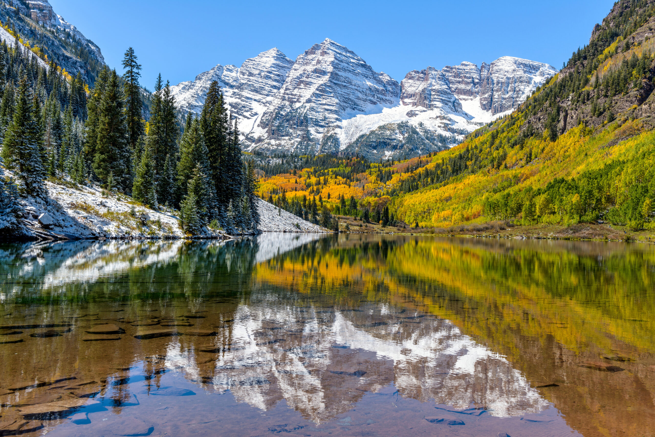
At 14,163 feet, Maroon Peak forms the south half of the Maroon Bells — the most photographed scene in Colorado and one of the most iconic mountain compositions in North America. The White River National Forest Service calls these peaks the “Deadly Bells” for their loose, unstable maroon-colored mudstone rock. The Class 3 South Ridge standard route, the Bells Traverse “Ringing the Bells” link-up to North Maroon, the rotten rock that demands testing every hold — the complete 2026 climbing guide.
Maroon Peak occupies a singular position in Colorado mountaineering culture. The mountain isn’t the highest in Colorado — Mount Elbert claims that title at 14,440 feet, 277 feet taller. It isn’t even the highest in the Elk Mountains — Castle Peak takes that distinction at 14,279 ft. What Maroon Peak holds, definitively, is iconic status as the southern half of the Maroon Bells. The peaks are widely considered the most photographed scene in Colorado. They form one of the most recognizable mountain compositions in North America. The Maroon Bells viewed from Maroon Lake’s u-shaped valley appear on countless calendars, postcards, social media posts, and tourism marketing. The peak’s profile is genuinely familiar to millions of people who have never set foot in the Elk Mountains.
The mountain stands in the Elk Mountains of central Colorado, within the Maroon Bells-Snowmass Wilderness Area of White River National Forest. The peak sits approximately 11 miles southwest of Aspen in Gunnison and Pitkin counties. Maroon Peak is also called South Maroon Peak to distinguish it from North Maroon Peak (14,019 ft) — the two summits separated by approximately 0.3 miles of dramatic ridgeline. Maroon Peak is the higher of the two Bells and the 24th highest of Colorado’s 58 fourteeners. The mountain has 712 meters of prominence and 12.97 km of isolation. From the south, west, and north, the peak presents the iconic pyramid profile that defines the Maroon Bells photography. From the east — the side photographers don’t see — the mountain reveals its dramatic technical climbing character.
The climbing itself sets Maroon Peak apart from other Class 3 Colorado 14ers. The White River National Forest Service formally calls the Maroon Bells the “Deadly Bells” because of the loose, unstable, maroon-colored mudstone rock found on all routes. The Colorado Fourteeners Initiative classifies the Maroon Bells as “among the most difficult and dangerous fourteeners” that “only experienced and knowledgeable climbers should attempt.” The peak’s standard South Ridge route is rated Class 3 — but it’s widely considered one of Colorado’s most demanding Class 3 fourteeners due to extensive loose rotten rock throughout the upper route. Every handhold and foothold must be tested before weighting it. The rotten red mudstone (the rock that gives the Bells their distinctive color) creates genuine objective hazards that distinguish these peaks from solid-rock Class 3 fourteeners elsewhere.
Find Hotels, Flights & Trips for the World’s Best Hiking Destinations
The Global Summit Guide Travel Shop on Expedia — curated for outdoor adventurers, mountaineers, and serious hikers. Patagonia to the Alps. Nepal to the Rockies. Curated lodging for every region we cover.
Explore Travel Shop on Expedia →This guide covers what you need to attempt Maroon Peak in 2026. The South Ridge standard route in detail, including the famous “Green Monster” 2,000-foot vertical climb through loose dirt and the upper Class 3 climbing through rotten rock gullies. The Bells Traverse “Ringing the Bells” low Class 5 link-up to North Maroon Peak — one of Colorado’s four great 14er traverses. Maroon Lake reservation logistics and Crater Lake’s bear-driven 2014 camping closure. Gear, season analysis, and safety considerations. And honest assessment of who should attempt this peak. Despite its Class 3 standard rating, Maroon Peak demands more careful climbing technique than most Class 3 fourteeners. The unique character of its rotten rock creates the elevated demand.
Maroon Peak At a Glance
The essential reference facts for Maroon Peak. Detailed sections follow below.
| Summit elevation | 14,163 ft (4,317 m) |
|---|---|
| Alternative name | South Maroon Peak (distinguishing from North Maroon Peak) |
| Location | Elk Mountains, central Colorado, USA |
| Coordinates | 39.0708°N, 106.9890°W |
| Colorado rank | 24th highest 14er in Colorado |
| North America rank | 49th highest peak |
| Prominence | 712 m (2,336 ft) |
| Isolation | 12.97 km (8.06 mi) |
| Counties | Gunnison and Pitkin counties |
| Mountain range | Elk Mountains |
| Wilderness area | Maroon Bells-Snowmass Wilderness |
| National forest | White River National Forest |
| The two Bells | Maroon Peak (14,163 ft) + North Maroon Peak (14,019 ft), separated by ~0.3 miles |
| Dangerous reputation | “Deadly Bells” — Forest Service nickname for loose rotten rock that has claimed lives |
| Famous viewpoint | Most photographed scene in Colorado (Maroon Lake u-shaped valley) |
| Standard route | South Ridge (Class 3, sustained) |
| Bells Traverse | “Ringing the Bells” — low Class 5, one of four great Colorado 14er traverses; 1-2 hours between peaks in good weather |
| First ascent | 1890s by C. Wilson |
| Famous route feature | “The Green Monster” — 2,000 ft vertical climb through loose dirt to south ridge |
| Trailhead | Maroon Lake Trailhead (9,580 ft) |
| Trail distance | ~12 miles round trip |
| Total elevation gain | ~4,800 ft |
| Crater Lake camping | CLOSED since 2014 due to bear activity |
| Best season | Late June to mid-September (peak window mid-July to August) |
| Maroon Lake access | Vehicle reservation $10-$16 OR Aspen Highlands shuttle $16-$20 round trip (peak season) |
| 2026 guided cost | $1,000-$2,000 for 2-day guided programs |
| Gateway towns | Aspen (11 miles); Carbondale; Snowmass Village |
The Maroon Bells are among the most difficult and dangerous Colorado fourteeners. The Colorado Fourteeners Initiative classifies the Maroon Bells — both Maroon Peak and North Maroon Peak — as “among the most difficult and dangerous Fourteeners.” CFI states “only experienced and knowledgeable climbers should attempt” these peaks. The White River National Forest Service calls them the “Deadly Bells” for loose, unstable maroon-colored rock found on all routes. The rotten red mudstone composition creates conditions where holds break unexpectedly — every handhold and foothold must be tested before weighting it. Rock falls present serious risks to both the climber and people below on the route. Multiple fatalities and rescues occur on these peaks regularly. Climbers approaching Maroon Peak should respect its serious nature despite its Class 3 standard rating — this isn’t a typical Class 3 fourteener.
Why Maroon Peak Earns Its Iconic Reputation
Maroon Peak holds a precise position in Colorado mountaineering culture that few other peaks match. The mountain combines four distinguishing elements. First, status as the most photographed scene in Colorado alongside North Maroon Peak. Second, the “Deadly Bells” reputation for genuinely dangerous loose rotten rock. Third, the Bells Traverse as one of Colorado’s four great 14er traverses. Finally, the famous “Green Monster” approach that defines the South Ridge route. The combination creates a peak that’s simultaneously aesthetically beloved and genuinely demanding to climb.
The Most Photographed Scene in Colorado
The view of the Maroon Bells from Maroon Lake is widely reputed to be the most photographed scene in Colorado. The composition — twin pyramidal peaks framed within the gorgeous u-shaped Maroon Lake valley — appears on countless calendars, postcards, social media posts, and tourism marketing materials. The peaks’ distinctive maroon color comes from the red mudstone that defines the Elk Mountains’ geology. The color combines with the lake reflection during calm mornings. The result is what many consider Colorado’s most iconic image. In spring, summer, fall, and winter, the Maroon Bells remain visually compelling. Legions of vacationers visit the Maroon Lake area each year for the photography alone, with peak summer days drawing thousands of visitors. Climbing Maroon Peak means becoming part of this iconic visual landscape — standing on the south summit of one of the most photographed mountains in North America.
The “Deadly Bells” Reality
The White River National Forest Service formally calls the Maroon Bells the “Deadly Bells” — a nickname based on the loose, unstable maroon-colored mudstone rock found on all routes. The rock composition isn’t just visually distinctive; it creates genuine objective hazards. The red mudstone is rotten, loose, downsloping, and unstable. Every handhold and foothold must be tested before weighting it because rock that looks solid often isn’t. Rockfall hazards present serious risks to both the climber and anyone below on the route. Helmets aren’t optional — they’re essential. Recent climbing seasons have seen multiple fatalities and helicopter rescues on the peaks. One 2025 trip report describes a climber falling from the summit during a recent attempt. Only quick action by another hiker saved his life despite severe spinal injury. A few days later a woman fell and broke her leg requiring another helicopter rescue. The “Deadly Bells” name isn’t marketing — it’s earned.
The Bells Traverse — “Ringing the Bells”
The traverse between Maroon Peak and North Maroon Peak — known as “Ringing the Bells” when both summits are climbed in one day — ranks among Colorado’s four great 14er traverses. The traverse is rated low Class 5 with sustained Class 3-4 ridge scrambling and route-finding through what one climber describes as “a rock climber’s playground” with multiple variations. Experienced climbers complete the traverse in 1-2 hours between peaks during good weather. Many parties choose to bring ropes for protection during the few Class 5 moves, though gear placement on the rotten rock can be difficult. The traverse can be done in either direction, with south-to-north (from Maroon Peak to North Maroon Peak) being the more popular direction. The achievement of completing the full Bells Traverse represents one of the more prestigious Colorado 14er accomplishments — combining two summits, sustained difficulty, and the iconic Bells aesthetic in a single day.
The Famous “Green Monster”
The South Ridge route on Maroon Peak features a famous section called the “Green Monster.” The section is a 2,000-foot vertical climb through loose dirt and rotten rock. It ascends from the West Maroon Creek drainage up to the south ridge. The section gains its name from the green-tinged loose dirt that climbers ascend, though “monster” refers more to the suffering than the appearance. The Green Monster represents the route’s primary fitness challenge — sustained climbing on poor footing that demands patience and energy management. The climb is loose enough that climbers ahead of you can dislodge rock. The section becomes increasingly demanding as climbers fatigue during the morning’s first hours. Most climbers describe the Green Monster as the route’s psychological crux — the section where the day’s commitment becomes serious. The summit ridge climbing that follows is more technically demanding but more enjoyable than the unrelenting Green Monster grind.
Crater Lake camping has been closed since 2014. All campsites in the Crater Lake area have been closed by the White River National Forest since August 2014 due to bear activity. This closure significantly affects Maroon Peak climbing logistics — most climbers historically used Crater Lake (10,076 ft) as a high camp for early morning departures, but this option no longer exists. Modern climbers must approach Maroon Peak as a long day trip from the Maroon Lake Trailhead (9,580 ft) — typically starting at 02:00-04:00 and returning 12-16 hours later. The closure adds significant logistical pressure: the full 12-mile round trip with 4,800 feet of elevation gain must be completed in a single day. Climbers who’d planned for Crater Lake camping need to revise their expedition planning. Alternative options exist. Climbers can arrive at the Maroon Lake area very early and start from the parking lot. Alternatively, climbers stay in Aspen or Carbondale the night before with a very early morning drive to the trailhead.
Who Should Climb Maroon Peak?
Maroon Peak sits at a demanding position in standard route 14er difficulty. The peak is appropriate only for climbers who have completed multiple Class 3 fourteeners and can demonstrate competence with sustained exposure on loose rock. Honest pre-trip self-assessment matters considerably here — the “Class 3” rating significantly understates the route’s serious nature compared to typical Class 3 fourteeners.
Maroon Peak Is Appropriate For:
Climbers with multiple Class 3 14er ascents. Climbers who’ve successfully completed Wetterhorn Peak, Mount Sneffels, Longs Peak Keyhole, Crestone Peak, and similar Class 3 fourteeners have the technical foundation. Maroon Peak demands more sustained route attention than easier Class 3 peaks — it builds on rather than introduces Class 3 climbing.
Climbers comfortable with genuinely loose rock. The mudstone rock composition demands constant skepticism about every hold. Climbers who’ve experienced loose rock on Pyramid Peak, North Maroon Peak, or similar Elk Range peaks have the foundation. Climbers used to solid Sangre de Cristo rock find Maroon Peak unsettling at first.
Climbers preparing for Capitol Peak or Bells Traverse. Maroon Peak serves as ideal preparation for harder Elk Mountains objectives. Climbers building toward Capitol Peak or the Bells Traverse benefit from Maroon Peak experience. Most climbers complete Maroon Peak before attempting the Bells Traverse.
Strong day-hike capability. The 12-mile round trip with 4,800 feet of elevation gain combined with the Crater Lake camping closure demands serious day-hike fitness. Climbers must be able to maintain steady pace for 12-15 hours.
Pre-dawn departure commitment. The pre-dawn 02:00-04:00 departure from the Maroon Lake Trailhead isn’t optional. Climbers must commit to the early start to manage afternoon thunderstorms — the South Ridge route’s extensive time above treeline creates serious lightning exposure.
Climbers with route-finding ability. The South Ridge route demands navigation through complex ledges, gullies, and ridge sections. Climbers who’ve completed routes with route-finding complexity (Crestone Needle, North Maroon Peak) have the relevant experience.
Maroon Peak Is Not Appropriate For:
Climbers without Class 3 experience. The Class 3 climbing demands real competence. Climbers without prior Class 3 fourteener experience should build skills on easier peaks first. The route’s loose rock character amplifies the technical challenge beyond pure difficulty grade.
First-time 14er climbers. Maroon Peak isn’t a first 14er, second 14er, or even fifth 14er for most climbers. Complete progression through Class 1-2 and easier Class 3 peaks first.
Climbers without lightning awareness. The South Ridge route’s extensive above-treeline travel creates serious lightning exposure. Climbers who don’t understand mountain lightning danger or won’t commit to pre-dawn starts face elevated risk.
Climbers expecting solid rock. The rotten mudstone is genuinely unlike most Colorado 14er rock. Climbers expecting Sangre de Cristo-style solid conglomerate find Maroon Peak demands different technique and mindset.
Climbers on rigid schedules. Weather windows and route conditions demand flexibility. Climbers locked into specific summit dates face pressure to climb in marginal conditions. Build buffer days into the schedule.
Solo climbers. The complex route, loose rock hazards, and remote setting make solo attempts genuinely dangerous. Plan in teams of 3-4 partners with strong group dynamics.
Where Maroon Peak Fits in Your Colorado 14er Progression
| Stage | Peak / Experience | Difficulty | What it builds |
|---|---|---|---|
| Foundation | Mount Bierstadt, Mount Sherman, Mount Elbert | Class 1 walk-ups | Altitude exposure, basic 14er fitness |
| Class 2 scrambles | Quandary Peak, Mount Massive, Grays Peak | Class 2 | Off-trail navigation, talus hopping |
| First Class 3 challenges | Mount Sneffels, Wetterhorn Peak, Longs Peak Keyhole | Class 3 brief | Brief technical sections; exposed terrain |
| Sustained Class 3 | Crestone Peak via Red Gully | Class 3 sustained | Longer Class 3 climbing; loose-rock introduction |
| The Maroon Peak step | Maroon Peak via South Ridge | Class 3 + rotten rock | Sustained Class 3 on genuinely loose rock; Elk Mountains experience |
| Loose-rock Class 4 | North Maroon Peak, Pyramid Peak | Class 4 loose | Pure Class 4 with rotten rock; sustained exposure |
| Great Colorado traverses | Bells Traverse “Ringing the Bells” | Low Class 5 | Combined Maroon + North Maroon in one day |
| The Class 4 final step | Capitol Peak via Knife Edge | Class 4 sustained | Most demanding standard 14er route in Colorado |
| Beyond 14ers | Alaska Range; Canadian Rockies | Class 5+ | Where Maroon’s lessons apply outside Colorado |
The Standard Routes Up Maroon Peak
Three routes exist on Maroon Peak. The South Ridge handles approximately 85% of climbers as the standard line. The Bells Traverse from North Maroon provides a famous link-up option. The East Face routes are reserved for technical climbers.
| Route | Side | Difficulty | Round trip | Usage |
|---|---|---|---|---|
| South Ridge (Standard) | South | Class 3 sustained | ~12 mi | ~85% of climbers |
| Bells Traverse from North Maroon | North ridge connection | Low Class 5 | ~14 mi total | ~10% of climbers |
| East Face Routes (multiple) | East | Class 5 technical | ~10 mi | ~5% of climbers |
Route 1: South Ridge (Standard — 85% of climbers)
The South Ridge is the standard climbing line on Maroon Peak and the only Class 3 route to the summit. The route starts at the Maroon Lake Trailhead (9,580 ft). The trail goes southwest to Crater Lake (10,076 ft) at 1.7 miles. Then it heads south along West Maroon Creek before heading west up Maroon Peak. The famous “Green Monster” 2,000-foot vertical climb gains the south ridge near 13,300 feet. From there, the route traverses ledges and ascends through gullies with exposed Class 3 climbing to the summit at 14,163 ft. Most parties complete the climb as a long day trip due to the Crater Lake camping closure (2014).
The Full Route Progression
- Maroon Lake Trailhead (9,580 ft): Standard starting point. Vehicle reservation system in effect during peak season (May-October) — $10-$16 vehicle parking OR Aspen Highlands shuttle bus $16-$20 round trip. Trailhead has restrooms but no other facilities.
- Approach to Crater Lake (9,580-10,076 ft): 1.7-mile hike via the well-maintained Maroon Lake Trail. Approximately 1-1.5 hours. The trail climbs through aspen and conifer forest with stunning Maroon Bells views throughout. Crater Lake has NO camping (closed since 2014 due to bear activity).
- West Maroon Creek (10,076-11,500 ft): Continue south along West Maroon Creek for approximately 2 miles. The trail begins climbing more steadily through alpine meadows. Pause at obvious cairns marking the turn toward Maroon Peak — easy to miss in low light.
- The Green Monster (11,500-13,300 ft): The infamous 2,000-foot vertical climb through loose dirt and rotten rock to the south ridge. Approximately 3-4 hours of demanding climbing on poor footing. Pace steady — pushing too fast on the loose dirt wastes energy. Multiple route variations exist through the broken terrain.
- Gain south ridge (13,300 ft): The ridge crest. Pause for water, food, and final gear check. The technical climbing begins here. Helmets essential from this point forward.
- Traverse ledges (13,300-13,550 ft): Follow ledges along the south ridge. Route-finding through cairns. The terrain is exposed Class 3 with significant drops. Test every hold.
- The “robot-shaped rock” exit (13,550 ft): A distinctive rock formation marks an important route-finding point. Continue along ledges past this landmark.
- The broad gully (13,550-13,800 ft): A broad gully separating Point 13,753′ and the summit. Enter the gully, turn right, and ascend. The route turns left at the top to a notch in the south ridge.
- Final summit climbing (13,800-14,163 ft): Climb onto ledges, continuing to a small slope with exposed ledges. This section includes some of the most exposed and challenging climbing on the route. Pass below cliffs to reach a corner. Turn right around the corner, scramble briefly to the ridge crest, and follow the ridge to the summit.
- Summit at 14,163 ft: Maroon Peak’s summit. Stunning views of the Elk Mountains, the Bells Traverse ridge to North Maroon Peak, and across to Pyramid Peak and other Elk 14ers. Stay 20-30 minutes for photos and absorption before beginning the descent.
- Descent: Reverse the route exactly — DO NOT attempt alternative descents. The Green Monster descent demands patience due to the loose dirt. Most parties take 4-5 hours to descend from summit to the Maroon Lake Trailhead. Total day from trailhead: 12-15 hours.
Strengths
- Most iconic Colorado mountain setting
- Only Class 3 route up the Bells (others are Class 4+)
- Spectacular alpine scenery throughout
- Builds toward Bells Traverse capability
- Strong sense of achievement on summit
- Less technical than North Maroon Peak
Considerations
- “Deadly Bells” — genuinely loose rotten rock
- 12-mile round trip is long
- The Green Monster wears climbers down
- Crater Lake camping closed since 2014
- Significant lightning exposure above treeline
- Multiple fatalities and rescues annually
Route 2: Bells Traverse from North Maroon — “Ringing the Bells”
The Maroon Bells Traverse — known as “Ringing the Bells” when both summits are climbed in one day — ranks among Colorado’s four great 14er traverses. The traverse covers the 0.3-mile ridge between North Maroon Peak (14,019 ft) and Maroon Peak (14,163 ft) with sustained Class 3-4 ridge scrambling and a few low Class 5 moves. Experienced climbers complete the traverse in 1-2 hours between peaks during good weather. The more popular direction is south-to-north (from Maroon Peak to North Maroon), descending North Maroon’s Northeast Ridge route (Class 4). Many parties carry rope for protection during the Class 5 moves, though gear placement on the rotten rock can be difficult. The traverse can be done in either direction depending on partner preferences and energy management. The achievement of completing the full Bells Traverse represents one of the more prestigious Colorado 14er accomplishments — combining two summits in a single day on iconic peaks.
Route 3: East Face Routes (Technical Alternatives)
The dramatic east face of Maroon Peak presents technical rock climbing well beyond standard 14er scrambling. Multiple route variations exist at Class 5 and harder grades. The face requires roped climbing with full protection and rock climbing competence. Commercial guiding doesn’t typically operate on these routes. Climbers attempting east face routes are typically experienced rock climbers seeking technical variety beyond the standard South Ridge. The face provides genuine alpine rock climbing in a setting unique to the Elk Mountains. Few documented modern ascents exist on these routes. Most parties seeking technical Maroon Peak climbing combine Class 5 sections within the standard South Ridge route. They rarely commit to pure east face climbing.
Maroon Peak Climbing History: From 1890 to 2026
The Elk Mountains region was home to Ute peoples for centuries before European contact. The Northern Ute and various other indigenous groups maintained extensive territorial and spiritual connections to the Roaring Fork Valley and surrounding mountains. The peaks now called the Maroon Bells held significance in indigenous traditions long before European-American climbing activity. Modern recognition of this heritage is increasingly part of cultural acknowledgment surrounding the Elk Mountains.
The Hayden Geological Survey and subsequent expeditions surveyed the Elk Mountains during the 1870s and 1880s. The peaks took their name “Maroon Bells” from their distinctive maroon color (the red mudstone composition that defines the Elk Mountains’ geology) and their dual bell-shaped profile. Early surveyors measured the peaks’ heights and established their place in early Colorado geographic knowledge. The mining boom in Aspen during this era brought increased attention to the surrounding mountains but most early visitors focused on resource extraction rather than climbing.
The first recorded ascent of Maroon Peak occurred in the 1890s by C. Wilson. The achievement was significant because the Maroon Bells were widely considered dangerous to climb due to the loose rotten rock found on all routes. Wilson’s ascent established the basic line that became the modern South Ridge standard route. The first ascent came during a period when many Colorado fourteeners were being climbed for the first time, with the Maroon Bells among the more technically demanding objectives accessible to early climbers. The North Maroon Peak first ascent followed in a similar timeframe.
Through the early 20th century, the Maroon Bells saw few ascents. The peaks’ technical demands and the loose rock character deterred most early climbers. Colorado Mountain Club members and small parties of experienced climbers made occasional ascents. The peaks’ reputation as some of Colorado’s most dangerous fourteeners began establishing itself during this era. The “Deadly Bells” nickname from the White River National Forest Service emerged as accidents and fatalities accumulated.
The mid-20th century brought systematic interest in completing all of Colorado’s 14ers. Maroon Peak became part of standard 14er progression for serious climbers. Simultaneously, the Maroon Bells viewed from Maroon Lake became one of Colorado’s iconic photographic scenes — appearing in countless postcards, magazines, and tourism marketing throughout the era. The combination of climbing prestige and photographic fame established the peaks’ modern reputation. Carl Blaurock, Bill Ervin, and other early “all 14ers” climbers had to complete Maroon Peak as part of their pursuit.
Congress designated the Maroon Bells-Snowmass Wilderness in 1964 with significant expansion in 1980. The wilderness protected the area including the Maroon Bells, Capitol Peak, Snowmass Mountain, and the surrounding peaks. The wilderness designation prohibited mechanical access while preserving the wild character of the region. Maroon Peak became firmly established as a wilderness climbing objective requiring approach hiking and respect for backcountry travel ethics. The wilderness status added regulatory framework for managing the increasing visitor pressure on the famous Maroon Lake area.
The 2000s saw rapid growth in Colorado 14er climbing as a recreational pursuit. Lists, guidebooks, and online resources (14ers.com launched in 2001) drove tens of thousands of climbers to attempt all 54-58 Colorado peaks above 14,000 feet. Maroon Peak’s annual ascent numbers grew dramatically during this period. The increased climbing traffic brought increased accident numbers and rescues, though the peaks’ character — and the loose rock reality — remained unchanged. Mountain Rescue Aspen became increasingly active on the Maroon Bells.
The 2010s brought dramatically increased visitor pressure on the Maroon Lake area. The “most photographed scene in Colorado” reputation, combined with social media amplification, drove millions of visitors to the area annually. Aspen Highlands shuttle bus service expanded to handle increased traffic. Vehicle reservations became necessary for parking management. The Maroon Lake corridor became one of Colorado’s most-visited backcountry destinations. The increased traffic also brought increased climbing attempts and proportional increases in rescues and fatalities.
The White River National Forest closed all campsites in the Crater Lake area in August 2014 due to bear activity. The closure significantly changed Maroon Peak climbing logistics — climbers had historically used Crater Lake (10,076 ft) as a high camp for early morning departures, but this option no longer existed. Modern climbers must approach Maroon Peak as a long day trip from the Maroon Lake Trailhead. The closure added significant logistical pressure to an already demanding climb. The bear activity that prompted the closure has continued through subsequent years, maintaining the camping prohibition.
The 2017 Capitol Peak season — with its five fatalities in six weeks — drew increased attention to the broader Elk Mountains safety challenges. The Maroon Bells received increased safety messaging from Mountain Rescue Aspen and the Colorado Fourteeners Initiative. CFI formally classified the Maroon Bells as “among the most difficult and dangerous Fourteeners” requiring only experienced and knowledgeable climbers. Annual fatality numbers on the Maroon Bells continued at typical levels — single-digit fatalities and helicopter rescues most seasons.
The COVID-19 pandemic initially reduced 14er climbing traffic in 2020 but quickly reversed as climbers sought outdoor activities during pandemic restrictions. The 2021 and 2022 seasons saw return to peak visitor numbers. The Maroon Bells continued seeing accidents and rescues at typical rates throughout the era. The vehicle reservation system was refined to manage post-pandemic visitor pressure on the Maroon Lake area. Bear activity remained sufficient to maintain the Crater Lake camping closure throughout the era.
The 2025 climbing season saw multiple documented accidents on the Maroon Bells. One trip report described a climber falling from the summit during a recent attempt — only quick action by another hiker saved his life despite severe spinal injury. A few days later a woman fell and broke her leg requiring helicopter rescue. The 2025 season reinforced the peaks’ continued hazardous character despite increased awareness of the dangers. The pattern across recent years remains consistent — the rotten rock and complex route-finding create conditions where accidents continue occurring at meaningful rates.
The 2026 climbing season is currently active with the late June through mid-September window. Maroon Lake vehicle reservations and Aspen Highlands shuttle bus service operate as in recent seasons. The Crater Lake camping closure remains in effect. The Maroon Bells continue serving as one of Colorado’s most iconic and demanding fourteener destinations. Climbers approaching the peaks in 2026 benefit from extensive online route documentation, CFI safety messaging, and improved understanding of the rotten rock character — but the underlying route hazards remain unchanged. Maroon Peak demands the same level of respect and competence today as it has across its climbing history.
The Deadly Bells Safety Lessons: What the Rotten Rock Demands
The Maroon Bells’ reputation as the “Deadly Bells” reflects specific safety patterns that climbers must understand before attempting the peaks. The rotten red mudstone composition creates conditions unlike most Colorado 14ers. Understanding these patterns and adapting climbing technique accordingly is essential pre-trip preparation.
The Rotten Red Mudstone Reality
The Maroon Bells’ distinctive maroon color comes from red mudstone — a sedimentary rock that’s loose, rotten, downsloping, and unstable. The rock isn’t just visually different from typical Colorado 14er geology; it behaves differently under climbing weight. Holds that look solid often aren’t. Rock that appears bedded into the slope can pull out as a single block when weighted. The downsloping character means rock tends to slide downhill rather than break cleanly. Climbers used to solid Sangre de Cristo conglomerate, Front Range granite, or other typical Colorado 14er rock find the Maroon Bells genuinely unsettling at first. The transition isn’t just technical — it’s psychological. Building trust in your hold-testing technique while accepting that some “good” holds will still fail is part of climbing competence on these peaks.
The Five Critical Safety Rules
| Rule | Why It Matters | How to Apply |
|---|---|---|
| Test every hold | Rock that looks solid often isn’t. Holds that seem bedded in pull out as blocks. The rotten mudstone deceives experienced climbers used to solid rock. | Tap each hold before weighting. Push or kick gently to feel for movement. When in doubt, find another hold. |
| Push down, don’t pull out | The downsloping character of the rock means pulling out on holds is much more likely to release them than pushing down. The 14ers.com Bells Traverse guide explicitly states: “push down on rocks rather than pull out on them.” | Choose handholds you can push down on rather than pull outward against. Use feet to drive movement rather than upper body pulling. |
| Wear a helmet | Rockfall is genuinely common on the Maroon Bells. Climbers above you can dislodge rock onto you. Your own movement can release rocks. Helmets are essential, not optional. | Helmets on from the Green Monster or Class 3 terrain through descent to treeline. No exceptions. |
| Watch climbers above and below | Rockfall affects everyone on the route. Climbers above can release rock onto you. Your own movement can endanger climbers below. Spatial awareness matters. | Communicate “ROCK!” if you dislodge anything. Avoid climbing directly above or below other parties. Wait for clearance through narrow sections. |
| Manage lightning timing | The South Ridge route requires extensive time above treeline where lightning poses serious risk during summer monsoon. Multiple lightning incidents documented on these peaks. | Pre-dawn 02:00-04:00 departure. Plan to be above treeline only during stable morning conditions. Off the upper mountain by 12:00-13:00. |
The “push down, don’t pull out” rule explained in detail. The fundamental difference between climbing on the Maroon Bells and climbing on most other Colorado 14ers comes down to rock orientation and composition. The maroon mudstone is downsloping — meaning the rock layers slope downward away from the mountain. When you pull outward on a hold, you’re pulling against the direction the rock wants to move. When the bonds holding the rock break, it pulls toward you. When you push down on a hold, you’re driving the rock back into the slope. The bonds may still break, but the rock tends to stay roughly in place. This principle is most important when transitioning across loose terrain. Choose handholds you can push down on rather than pull against. Use your feet to drive movement rather than your upper body pulling you up. The technique feels unfamiliar to climbers used to typical Class 3 fourteener pulling, but it’s essential on the Bells.
Maroon Peak Summit Day Timeline: Hour-by-Hour from Maroon Lake Trailhead
Summit day on Maroon Peak typically runs 12-15 hours round trip from the Maroon Lake Trailhead (9,580 ft) to the summit at 14,163 ft and back. Strong, well-conditioned teams complete the round trip in 11-13 hours. Slower parties may take 15-17 hours. The Crater Lake camping closure forces day-trip logistics that make this one of the longer Colorado 14er climbing days.
Standard Maroon Peak Summit Day — Maroon Lake Trailhead (9,580 ft) to Summit (14,163 ft) and Return
Which Maroon Peak Approach Fits Your Situation?
The choice on Maroon Peak involves preparation level, partner selection, weather strategy, and whether to combine with North Maroon. Use this matrix to match yourself — recognizing this peak is appropriate only for experienced Class 3 14er climbers.
Match Yourself to a Maroon Peak Approach
When to Climb Maroon Peak: Season-by-Season Analysis
Mid-July to Mid-August: Peak Season
The prime Maroon Peak climbing window. The route is generally snow-free, the Maroon Lake area operates at full capacity, and the trail conditions are excellent. Trade-off: afternoon thunderstorms are most aggressive during the summer monsoon. Pre-dawn 02:00-04:00 starts essential. Crowds peak during weekend days — weekday attempts offer significantly fewer climbers on the route. Most successful Maroon Peak summits occur during this window. Photography conditions are best with consistent morning blue skies before afternoon convection.
Late August to Mid-September: Sweet Spot
Many experienced climbers consider this the optimal Maroon Peak window. Conditions remain excellent with slightly less aggressive afternoon weather as monsoon season ends. Crowds drop noticeably from peak summer. Daylight begins shortening but remains adequate. September photography opportunities are exceptional with autumn aspens turning gold in the lower approach. The Maroon Bells aspen colors are among Colorado’s most famous fall foliage displays.
Mid-September to Early October: Autumn Window
The autumn window brings stable weather, golden aspen colors in the lower approach valley, and significantly reduced crowds. The Maroon Lake area becomes particularly beautiful with the gold aspens reflecting in the lake. Temperatures drop noticeably — start with warmer layers than summer. Early October may bring first snow on the upper mountain. Conditions remain achievable but transition rapidly toward winter as the season progresses.
Late June to Early July: Early Season
Early July sometimes has remnant snow in upper gullies and on the south ridge. Climbers attempting in this window may need ice axe and crampons for snow-packed sections. The Green Monster typically has less remnant snow than the upper route. Daylight is at its longest — useful for the long day. The Maroon Lake area can have snow patches in the approach trail.
October-June: Off-Season
Winter ascents of Maroon Peak become extreme alpine mountaineering objectives requiring full winter mountaineering experience. Avalanche risk in the Elk Mountains is genuine throughout winter. The rotten rock combined with snow and ice creates conditions far more demanding than summer climbing. Most parties don’t attempt Maroon Peak in winter. Climbers attempting winter conditions face genuinely elevated risks far beyond the summer route’s already serious nature.
Climbing Maroon Peak in 2026: Cost Breakdown
Maroon Peak offers strong value among Colorado 14er climbing destinations. Free wilderness access combined with modest vehicle/shuttle reservation costs make independent climbing affordable. Guided climbing pricing reflects the route’s serious nature and demanding logistics.
Independent Climbing Costs
| Cost Component | 2026 Amount (USD) | Notes |
|---|---|---|
| Forest Service / Wilderness entry | $0 | Free wilderness access |
| Maroon Lake vehicle reservation | $10-$16 | Required during peak season (May-October) for vehicle parking |
| Aspen Highlands shuttle bus (alternative) | $16-$20 | Round trip from Aspen Highlands to Maroon Lake; required when parking full |
| Camping permits | $0 | N/A — Crater Lake camping closed since 2014; day-trip only |
| Aspen accommodation (per night) | $150-$500 | Hotels, motels, B&Bs; peak season especially expensive |
| Carbondale accommodation (per night) | $100-$250 | Alternative gateway; more affordable than Aspen |
| Snowmass Village accommodation | $150-$400 | Closer than Aspen for some trailhead access |
| Meals (Aspen/Carbondale restaurants) | $40-$120/day | Higher pricing in Aspen than Carbondale |
| Fuel (Denver to trailhead round trip) | $80-$140 | ~400 miles each way depending on vehicle |
| Technical climbing gear | $0-$300 | Helmet required; trekking poles recommended; satellite communicator advised |
| Total 2-day independent budget | $300-$700 | Excluding international travel and existing gear |
Guided Climbing Costs
| Program Type | 2026 Cost (USD) | What’s Included |
|---|---|---|
| 2-day guided Maroon Peak program | $1,000-$2,000 per person | Certified Colorado guide, summit day support; 2 climbers per guide typical |
| Private 1:1 or 1:2 guiding | $2,000-$3,500 per person | Custom dates, dedicated guide attention, flexible itinerary |
| Combined Maroon Peak + North Maroon Peak | $2,500-$4,500 per person | 3-4 day program with both peaks (separate ascents, not traverse) |
| Bells Traverse “Ringing the Bells” | $2,500-$5,000 per person | Guided traverse for experienced climbers; one of four great Colorado 14er traverses |
| Elk Mountains multi-peak program | $3,500-$6,000 per person | 7-10 day program with multiple Elk 14ers including Maroon Peak |
Why Maroon Peak guided pricing reflects route seriousness. Guided pricing on Maroon Peak runs higher per day than for easier Class 3 fourteeners. The reasons reflect actual program complexity. First, the route’s serious nature demands more experienced guides commanding higher fees. Second, the long 12-mile round trip with 4,800 feet of elevation gain requires considerable guide time commitment. Third, smaller client-to-guide ratios (typically 2:1 or 3:1) are essential for safety on the loose rock. Fourth, the loose rock character of the Maroon Bells means guides accept more responsibility for client safety than on solid-rock routes. Climbers wanting Maroon Peak guided experiences should book 4-6 months ahead, particularly for August 2026 dates. Operators including American Alpine Institute, Colorado Mountain School, and various Colorado-based independent guides offer programs. Two-day programs provide the right balance between safety margin and pricing efficiency.
Gear Checklist for Maroon Peak
Maroon Peak gear requirements emphasize loose-rock climbing equipment combined with summer alpine day-hike kit. The 12-mile round trip with 4,800 feet of elevation gain demands serious day-hike fitness with full equipment. Helmet is non-negotiable given the loose rock hazards.
Summit Day Climbing Gear
- Helmet (REQUIRED) — non-negotiable given loose rock hazards throughout the route
- Daypack 30-40L — for full-day kit including water, food, layers
- Sturdy hiking boots — high-cut leather or synthetic with aggressive lugs
- Approach shoes — alternative for trail sections (some climbers use lightweight footwear)
- Trekking poles — essential for the Green Monster descent
- Gaiters — for early-season snow or loose dirt sections
- Climbing harness (optional) — some parties carry harness for Bells Traverse or comfort on exposed ledges; rarely required for standard South Ridge
- 30m climbing rope (optional) — for Bells Traverse parties; most South Ridge climbers don’t use
Clothing System
- Base layer top and bottom — merino or synthetic; pre-dawn temperatures cold
- Hiking pants — quick-drying synthetic; convertible pants useful
- Mid-layer fleece or light insulated jacket — for cool starts and summit stops
- Light insulated jacket — for summit stops and weather changes
- Hardshell jacket — Gore-Tex or equivalent; thunderstorm protection essential
- Hardshell pants — for wet conditions or wind
- Warm hat / beanie
- Sun hat or visor
- Light gloves and warm gloves
- Trekking socks (2 pairs) — merino wool
Food, Water, and Safety
- Water capacity 3-4L for the day — limited water sources on upper route
- Trail meals and snacks for 12-15 hours
- Energy gels and bars
- Electrolyte supplements
- Sunscreen SPF 50+ and lip balm with SPF
- Glacier glasses or quality sunglasses (Cat 3)
- Personal first aid kit — blisters, ibuprofen, basic supplies
- Headlamp with spare batteries — ESSENTIAL for pre-dawn 03:00-04:00 starts
- Emergency bivy — for unexpected weather or injury
- Satellite communicator (Garmin inReach, Zoleo, ACR) — STRONGLY RECOMMENDED given limited cell service
- Map and compass — for route-finding
- GPS with route loaded (Caltopo or Gaia) — STRONGLY RECOMMENDED for upper mountain navigation
- Whistle — for emergency signaling
Early-Season Snow Equipment (Late June-Early July)
- Crampons — for snow-packed upper gullies — see our Crampons Buyer’s Guide
- Ice axe — straight-shaft general mountaineering axe — see our Ice Axe Guide
- Mountaineering boots — for crampon use in early season
Frequently Asked Questions About Climbing Maroon Peak
How tall is Maroon Peak and where is it located?
Maroon Peak (also called South Maroon Peak) rises to 14,163 feet (4,317 meters) in the Elk Mountains of central Colorado. The coordinates are 39.0708°N, 106.9890°W. The peak sits within the Maroon Bells-Snowmass Wilderness Area in White River National Forest, in Gunnison and Pitkin counties. Maroon Peak is the higher of the two Maroon Bells (the other being North Maroon Peak at 14,019 feet), separated by approximately 0.3 miles. The mountain is the 24th highest of Colorado’s 58 fourteeners with 712 meters of prominence. The standard climbing approach is from the Maroon Lake Trailhead via Crater Lake and West Maroon Creek.
How difficult is climbing Maroon Peak?
Maroon Peak’s standard South Ridge route is rated Class 3 — but it’s widely considered one of Colorado’s most demanding Class 3 fourteeners due to extensive loose rotten rock throughout the route. The White River National Forest Service calls the Maroon Bells the “Deadly Bells” for the loose, unstable maroon-colored mudstone rock that’s found on all routes. The Colorado Fourteeners Initiative classifies the Maroon Bells as “among the most difficult and dangerous fourteeners.” The CFI states “only experienced and knowledgeable climbers should attempt” the peaks. The route demands testing every handhold and foothold before weighting it. Total round trip from Maroon Lake Trailhead is approximately 12 miles with 4,800 feet of elevation gain.
What’s the standard route up Maroon Peak?
The standard route is the South Ridge from the Maroon Lake Trailhead. Climbers start at the Maroon Lake Trailhead (9,580 ft), hike approximately 1.7 miles to Crater Lake (10,076 ft), then continue south along West Maroon Creek before heading west up the mountain. The route includes the famous “Green Monster” — a 2,000-foot vertical climb through loose dirt to the south ridge near 13,300 feet. From the ridge, climbers traverse ledges and ascend through gullies with exposed Class 3 climbing to the summit at 14,163 ft. Total round trip is approximately 12 miles with 4,800 feet of elevation gain. Most parties complete the climb as a long day trip — Crater Lake camping has been closed since 2014.
When is the best time to climb Maroon Peak?
The Maroon Peak climbing season runs from late June through mid-September, with the optimal window being mid-July through August. July can have remnant snow in upper gullies. The summer monsoon brings daily afternoon thunderstorms that demand pre-dawn starts — most parties depart the Maroon Lake Trailhead between 02:00 and 04:00. September brings cooler temperatures, more stable weather, and reduced crowds. The Maroon Bells are notorious for lightning — the South Ridge route requires extensive time above treeline where lightning poses serious risk. Early October can bring first snow. The route is not climbed in winter conditions due to extreme avalanche risk.
How much does climbing Maroon Peak cost in 2026?
Climbing Maroon Peak is essentially free for independent climbers. The Maroon Bells-Snowmass Wilderness is free to enter. However, Maroon Lake area has a reservation system during peak season. Vehicle reservations cost $10-$16 for parking. Alternatively, shuttle bus service from Aspen Highlands runs $16-$20 round trip. Crater Lake camping has been closed since 2014, so most climbers do Maroon Peak as a long day trip. Independent climbers should budget approximately $40-$100 per day for fuel and food, plus accommodation in Aspen ($150-$500 per night during peak season) or Carbondale ($100-$250). Guided ascents are available, typically running $500-$800 per person per day. Two-day guided programs run $1,000-$2,000 per person.
Why are the Maroon Bells called the “Deadly Bells”?
The White River National Forest Service formally calls the Maroon Bells the “Deadly Bells” because of the loose, unstable, maroon-colored mudstone rock found on all routes. The rotten red mudstone composition creates conditions where holds break unexpectedly — every handhold and foothold must be tested before weighting it. Rock that looks solid often isn’t. Rockfall hazards present serious risks to both the climber and anyone below on the route. The peaks have claimed multiple lives historically and continue seeing fatalities and helicopter rescues in modern climbing seasons. The Colorado Fourteeners Initiative classifies the Maroon Bells as “among the most difficult and dangerous Fourteeners” requiring only experienced and knowledgeable climbers.
What’s the Bells Traverse “Ringing the Bells”?
The Maroon Bells Traverse — known as “Ringing the Bells” when both summits are climbed in one day — ranks among Colorado’s four great 14er traverses. The traverse covers the 0.3-mile ridge between North Maroon Peak (14,019 ft) and Maroon Peak (14,163 ft) with sustained Class 3-4 ridge scrambling and a few low Class 5 moves. Experienced climbers complete the traverse in 1-2 hours between peaks during good weather. The more popular direction is south-to-north (from Maroon Peak to North Maroon), descending North Maroon’s Northeast Ridge route (Class 4). Many parties carry rope for protection during the Class 5 moves, though gear placement on the rotten rock can be difficult.
What’s the “Green Monster”?
The “Green Monster” is the famous 2,000-foot vertical climb on Maroon Peak’s South Ridge route — gaining the south ridge from the West Maroon Creek drainage. The section earns its name from the green-tinged loose dirt that climbers ascend, though “monster” refers more to the suffering than the appearance. The Green Monster represents the route’s primary fitness challenge — sustained climbing on poor footing that demands patience and energy management. The climb is loose enough that climbers ahead of you can dislodge rock. Most climbers describe the Green Monster as the route’s psychological crux — the section where the day’s commitment becomes serious. The summit ridge climbing that follows is more technically demanding but more enjoyable than the unrelenting Green Monster grind.
Can I camp at Crater Lake during a Maroon Peak attempt?
No — all campsites in the Crater Lake area have been closed by the White River National Forest since August 2014 due to bear activity. The closure significantly affects Maroon Peak climbing logistics. Modern climbers must approach Maroon Peak as a long day trip from the Maroon Lake Trailhead. Most parties drive to the trailhead from Aspen or Carbondale very early on summit day. Some parties choose to stay in Aspen the night before with a pre-dawn departure. The closure adds significant logistical pressure: the full 12-mile round trip with 4,800 feet of elevation gain must be completed in a single day. Climbers should plan for a 12-15 hour day from trailhead.
Should I climb Maroon Peak before North Maroon Peak?
Yes — most climbers should complete Maroon Peak (South Maroon, Class 3 standard route) before attempting North Maroon Peak (Class 4 standard route). Maroon Peak’s South Ridge serves as ideal preparation for North Maroon Peak’s harder Northeast Ridge. Climbers experience the rotten rock character on the easier of the two peaks before facing the technical Class 4 climbing on North Maroon. Once both peaks are completed individually, climbers can then attempt the Bells Traverse “Ringing the Bells” — combining both peaks in one day via the low Class 5 ridge connection. The progression of Maroon Peak first, North Maroon Peak second, and Bells Traverse third represents the standard approach to the Maroon Bells objectives.
Maroon Peak Planning Resources
Sources & Further Reading
- Colorado Fourteeners Initiative (CFI) — Maroon Peak / South Maroon Peak route information (April 2026)
- 14ers.com — Maroon Peak South Ridge route description and Bells Traverse documentation
- SummitPost — South Maroon Peak climbing and hiking reference
- Wikipedia — Maroon Bells reference for elevation, geography, and first ascent
- Roaming Together — Climbing the Maroon Traverse: Colorado’s Most Notorious 14er Link-Up (November 2025)
- Peakery — Maroon Peak Colorado profile and Bells Traverse documentation
- U.S. Forest Service — White River National Forest and Maroon Bells-Snowmass Wilderness information
- Mountain Rescue Aspen — incident reports and safety messaging on Elk Mountains 14ers
- Alan Arnette — Maroon Bells Traverse documentation and climbing photography
- C. Wilson — 1890s first ascent historical documentation
Last updated: May 25, 2026. Next scheduled update: April 2027 (pre-season verification of Maroon Lake reservation system, vehicle/shuttle access, and any recent accident reports).
Planning a Colorado 14er Climbing Trip?
Maroon Peak is among Colorado’s most iconic fourteeners and one of the most demanding Class 3 standard routes — appropriate only for experienced Class 3 climbers. Ideally pursued as preparation for Capitol Peak, North Maroon Peak, or the Bells Traverse. See our complete Colorado 14ers guide for the full Rocky Mountain climbing picture.
View Colorado 14ers Guide →Was this helpful?
🏔Related peaks nearby
🧭Explore & compare
Global Summit Guide is an independent mountaineering resource founded in 2026. The team combines first-hand trekking and climbing experience with in-depth research and professional health and nutrition review to help climbers choose objectives, prepare properly, and stay safe.
Health, altitude, and nutrition content is reviewed by Taylor Ludlow (Registered Nurse) and Brigg Hoopes (Nutritionist).
What We Don't Know Yet
Mountain information changes quickly. This box explains the limits of what this page can responsibly promise.
- Route conditions, trailhead access, crevasse exposure, stream crossings, and rescue access may vary from published planning guidance.
- Visa, passport, vaccination, border, insurance, and local transportation rules may change before your trip.
- Route conditions, snowpack, closures, and weather can change quickly after this page is updated.
- Permit rules, fees, quotas, and reservation windows may change between review cycles.
- Operator availability, pricing, guide ratios, and cancellation terms can change by season.
Verify current conditions with official land managers, guide services, local forecasts, and current route reports before booking or climbing.
Mountaineering, rock and ice climbing, glacier travel, and high-altitude activity are inherently dangerous and can result in serious injury or death. The information on Global Summit Guide is provided for general informational and educational purposes only and is not a substitute for professional instruction, qualified guiding, proper equipment, or your own judgment and experience.
Route conditions, weather, snowpack, permits, regulations, and hazards change constantly and may differ from what is described here. Details may be incomplete, out of date, or contain errors. Always verify current information with local authorities, certified guides, and official sources before making any decision in the mountains.
Nothing on this site is medical, legal, or financial advice. Our fitness, acclimatization, altitude, and nutrition content is general in nature; consult a qualified physician before beginning any strenuous exercise program or exposing yourself to high altitude.
You are solely responsible for your own safety and decisions. To the fullest extent permitted by law, Global Summit Guide and its team accept no liability for any loss, injury, damage, or expense arising from use of, or reliance on, this information. By using this site you acknowledge these risks and accept these terms.
Some links on this site may be affiliate links. If you buy through them we may earn a small commission at no extra cost to you; this never affects our recommendations.
Global Summit Guide recommendation path
Next Best Mountain to Research
Use these recommendations to continue the right planning path instead of stopping on one page.
Use current permit, weather, route, and operator information before booking or climbing.