web analytics

Tag: Torres del Paine O Circuit

  • Torres del Paine: W Circuit vs O Circuit

    Home · Mountains · Torres del Paine W vs O Circuit

    Torres del Paine: W Circuit vs O Circuit — Complete 2026 Comparison with Day-by-Day Itineraries, CONAF Permits, Refugio Booking, Costs, and Which Patagonia Trek to Choose

    The definitive 2026 comparison of Chilean Patagonia’s two legendary trekking circuits. Generally, the W Circuit is the popular classic — roughly 80 km over 4-5 days hitting the three main highlights (Mirador Las Torres, the French Valley, and Grey Glacier). Specifically, the O Circuit is the complete circumnavigation of the Paine Massif — roughly 130 km over 7-10 days. It adds the remote backside wilderness loop and the dramatic Paso John Gardner crossing with views over the Southern Patagonian Ice Field. Notably, both treks share the same iconic landmarks but deliver fundamentally different experiences. This guide gives you day-by-day itineraries, verified 2026 CONAF fees, the current refugio booking system, full cost breakdowns, and a clear decision framework.

    80 / 130 km
    W / O Distance
    4-5 / 7-10
    W / O Days
    $39-55
    2026 CONAF Entry
    Dec-Mar
    Best Season
    Chilean Patagonia · Magallanes Region · W Circuit (Classic) vs O Circuit (Full Loop) · Patagonia Trekking Overview →
    Last updated May 27, 2026 — verified 2026 CONAF park entry fees ($39 / $55 USD), current Las Torres Patagonia (formerly Fantastico Sur) and Vertice refugio booking system, and December-March season logistics

    Torres del Paine National Park sits in Chilean Patagonia’s Magallanes Region. It is home to two of the world’s most famous multi-day trekking routes — the W Circuit and the O Circuit. Generally, they share the same iconic destinations (the three granite towers, the French Valley amphitheater, Grey Glacier) but differ fundamentally in scope, duration, and character. Specifically, the W Circuit is the popular classic at roughly 80 km in 4-5 days. The O Circuit is the complete experience at roughly 130 km in 7-10 days, adding the remote backside wilderness loop. Notably, choosing between them is the single most important decision a first-time Patagonia trekker makes.

    This guide answers every question first-time Patagonia trekkers ask. How do the two circuits actually compare day by day? What does the 2026 CONAF permit cost and how do you book the refugios? Notably, we cover several concrete topics. First, a master side-by-side comparison of both circuits. Then day-by-day itineraries for the standard W (5 days) and O (8 days). Also the 2026 permit and refugio booking system through Las Torres Patagonia and Vertice. Plus full cost breakdowns from budget camping through guided expeditions. Plus the December-March season analysis and Patagonian weather realities. Finally, a clear decision framework for choosing your circuit.

    Torres del Paine at a Glance

    DetailInformation
    LocationMagallanes Region, Chilean Patagonia (southernmost Chile)
    Park size227,298 hectares (UNESCO Biosphere Reserve, 1978)
    Annual visitors~250,000 (all activities)
    Highest peakPaine Grande (3,050 m / 10,007 ft)
    The three towersTorre Central 2,850 m · Torre Norte 2,248 m · Torre Sur 2,500 m
    W Circuit~80 km · 4-5 days · ~90% of trekkers
    O Circuit~130 km · 7-10 days · ~10% of trekkers
    Best seasonDecember – March (Patagonian summer)
    Gateway townPuerto Natales (2.5 hr bus to park)
    Closest airportPunta Arenas (PUQ), 3 hr bus to Puerto Natales
    2026 park entry$39 USD (under 3 days) · $55 USD (3+ days)
    Refugio operatorsLas Torres Patagonia (formerly Fantastico Sur) + Vertice
    WildlifeGuanacos, pumas, Andean condors, foxes, rheas

    W vs O Circuit — The Master Comparison

    Before the day-by-day detail, here is the head-to-head comparison that answers most trekkers’ core question. Generally, the W Circuit wins on accessibility, schedule, and success rate, while the O Circuit wins on wilderness, solitude, and the complete-loop experience. Specifically, the table below summarizes every decisive factor. Notably, both circuits hit the same three marquee highlights — the O simply adds the backside wilderness around them.

    AttributeW CircuitO Circuit
    Total distance~80 km (50 miles)~130 km (80 miles)
    Standard duration4-5 days7-10 days (standard 8)
    Daily hiking15-20 km · 5-8 hours15-20 km · 6-11 hours (pass day longest)
    Maximum altitude~1,000 m at viewpoints1,241 m at Paso John Gardner
    Cumulative gain~3,000-4,000 m~4,500-5,500 m
    Signature highlightsTorres base, French Valley, Grey GlacierAll W highlights + Paso John Gardner + backside
    InfrastructureWell-developed refugios + campsW-side refugios + basic backside camps
    CrowdsModerate-heavy peak seasonHeavy on W section, light on backside
    Weather exposureModerateHigh (Paso crossing)
    Booking lead time6-9 months for peak9-12 months (backside limited)
    Typical cost$800-$2,500$1,200-$3,800
    DirectionEast-to-West or West-to-EastCounter-clockwise only
    Success rate85-90%75-80%
    Share of trekkers~90%~10%
    Ideal forFirst-time Patagonia, 5-7 daysExperienced trekkers, 8-12 days
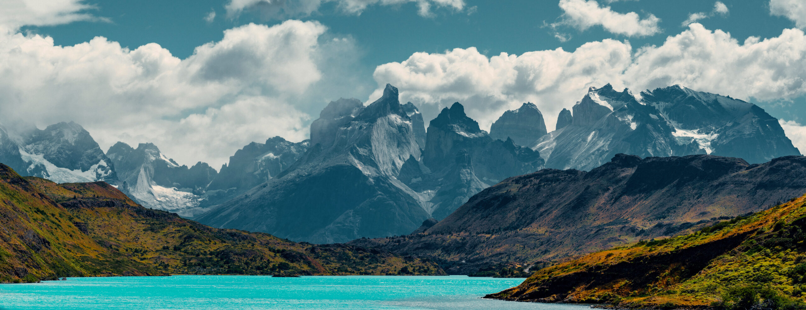
    Torres del Paine National Park Chilean Patagonia three granite towers turquoise lake dramatic peaks W Circuit O Circuit trekking Magallanes Region
    Torres del Paine National Park in Chilean Patagonia centers on the Paine Massif — a dramatic granite range dominated by the three signature towers that give the park its name. Generally, the W Circuit (80 km, 4-5 days) and O Circuit (130 km, 7-10 days) both traverse this 227,298-hectare UNESCO Biosphere Reserve. Notably, the iconic three-tower sunrise at Mirador Las Torres remains one of trekking’s most photographed moments, shared by both routes.

    The W Circuit — The Classic Route

    W Circuit — 80 km Over 4-5 Days

    All three main highlights · well-developed infrastructure · ~90% of trekkers · 85-90% success
    ~80 km
    Distance
    4-5 days
    Duration
    ~1,000 m
    Max Altitude
    85-90%
    Success Rate

    The W Circuit follows a W-shaped ground plan that connects Torres del Paine’s three main valleys. Generally, these are three valleys. The Ascencio Valley leads to Mirador Las Torres, the iconic three granite towers. The French Valley holds the dramatic Mirador Britanico amphitheater, and the Grey Valley ends at Glacier Grey. Specifically, each leg of the W requires hiking in and out of its respective valley, with connecting sections along Lake Nordenskjold and Lake Pehoe. Notably, this is Patagonia’s most accessible major multi-day trek.

    Several features make the W Circuit achievable for fit first-time Patagonia trekkers. These include well-developed refugios with dormitory beds and meals, clearly marked trails, catamaran service across Lake Pehoe, and abundant guided tour options. Generally, around 90% of Torres del Paine multi-day hikers choose the W, and it is overwhelmingly the right choice for most international visitors. Specifically, the main downsides are crowds during peak season (December-February) and the feeling of being on a popular route. Notably, the W hits all three marquee features, and for most trekkers the iconic three-towers sunrise makes any crowd worthwhile.

    W Circuit Day-by-Day Itinerary (Standard 5 Days)

    The standard 5-day W itinerary runs west-to-east or east-to-west. Generally, the east-to-west direction below starts at the Las Torres sector and finishes at the Lake Pehoe catamaran. Specifically, the towers sunrise hike happens early to maximize the chance of clear weather. Notably, daily distances and times assume moderate fitness and typical Patagonian conditions.

    DayRouteDistance / TimeHighlight
    Day 1Puerto Natales bus to park, hike to Las Torres sector~7 km · 2-3 hrsArrival, settle into Central/Chileno
    Day 2Pre-dawn hike to Mirador Las Torres, then transfer to Los Cuernos/Frances~22 km · 8-9 hrsThree granite towers at sunrise
    Day 3French Valley to Mirador Britanico, move to Paine Grande~25 km · 8-9 hrsFrench Valley amphitheater
    Day 4Hike to Grey Glacier viewpoint, stay Paine Grande/Refugio Grey~22 km · 6-7 hrsGrey Glacier and icebergs
    Day 5Catamaran across Lake Pehoe, bus to Puerto Natales~4 km + ferryDeparture

    W Circuit itinerary variations. Generally, the W flexes from 3 to 6 days. Specifically, a compressed 4-day W skips a rest stop, the standard 5-day W is most common, and a comfortable 6-day W adds a buffer/rest day for weather. Notably, a minimal 3-day W covers only the Torres Base Camp and French Valley, skipping Grey Glacier. The three-towers sunrise is weather-dependent — only 30-50% of trekkers get a clear sunrise on the first attempt, so building in flexibility helps. Compare the W’s difficulty to other classic treks in our Tour du Mont Blanc guide.

    The O Circuit — The Full Loop

    O Circuit — 130 km Over 7-10 Days

    Complete circumnavigation · backside wilderness + Paso John Gardner · ~10% of trekkers · 75-80% success
    ~130 km
    Distance
    7-10 days
    Duration
    1,241 m
    Paso John Gardner
    75-80%
    Success Rate

    The O Circuit is a complete circumnavigation of the Paine Massif. Generally, it includes all W Circuit highlights plus a backside wilderness loop. The loop runs through Seron, Dickson, and Los Perros camps before crossing the dramatic Paso John Gardner (1,241 m). Specifically, the pass offers sweeping views of the Southern Patagonian Ice Field. It then descends to rejoin the Grey Glacier area. From there you complete the standard W route back to the start. Notably, this backside section sees maybe 10% of park visitors, meaning long stretches of solitude through glaciated valleys and lenga forests.

    Paso John Gardner’s crossing day is the trek’s physical and emotional climax. Generally, it is 9-11 hours of hiking culminating in the panoramic ice field view that has become one of Patagonia’s most famous vistas. Specifically, the O Circuit delivers the complete Torres del Paine experience but requires significantly more time, fitness, and advance planning. Notably, the backside camps (Seron, Dickson, Los Perros) are more basic than W Circuit refugios. Weather can close Paso John Gardner for days. Reservations are tighter because of the limited capacity on the backside.

    O Circuit Day-by-Day Itinerary (Standard 8 Days)

    The O Circuit is hiked counter-clockwise, starting with the backside wilderness loop and finishing on the W section. Generally, this direction is mandatory — park rules require the O to start from Seron and proceed counter-clockwise. Specifically, the standard 8-day itinerary below front-loads the remote camps and saves the iconic towers for the final morning. Notably, Day 4 (the Paso John Gardner crossing) is the longest and hardest day of either circuit.

    DayRouteDistance / TimeHighlight
    Day 1Laguna Amarga entrance to Seron camp~15 km · 6-7 hrsEnter the quiet backside
    Day 2Seron to Dickson camp~18 km · 7-8 hrsRemote Lake Dickson
    Day 3Dickson to Los Perros camp~12 km · 5-6 hrsPerros Glacier
    Day 4Los Perros to Grey via Paso John Gardner (1,241 m)~15 km · 9-11 hrsIce Field view — longest, hardest day
    Day 5Grey to Paine Grande (now on W section)~11 km · 4-5 hrsGrey Glacier
    Day 6Paine Grande to French Valley and Los Cuernos~6-7 hrsFrench Valley amphitheater
    Day 7Los Cuernos to Chileno~6-8 hrsPosition for towers sunrise
    Day 8Pre-dawn Torres Base viewpoint, descend to exit, bus to Puerto NatalesFull dayThree towers at sunrise, departure

    Paso John Gardner weather warning. Generally, the Paso John Gardner crossing is the O Circuit’s crux and its biggest weather risk. Specifically, the 1,241 m pass can close for days when high winds or snow hit — Patagonian wind regularly exceeds 100 km/h at exposed elevations. Notably, the remote Dickson and Los Perros camps have limited exit options, so trekkers caught by weather may need to wait it out. Always build buffer days into an O Circuit plan, and review our mountain weather guide for reading Patagonian forecasts. The O Circuit’s lower 75-80% success rate compared to the W’s 85-90% largely reflects pass closures and the longer, more committing route.

    Torres del Paine Paso John Gardner pass O Circuit Southern Patagonian Ice Field backside wilderness Dickson Los Perros camps glaciated valleys trekking
    The O Circuit’s backside wilderness loop crosses Paso John Gardner (1,241 m), the trek’s physical climax with sweeping views over the Southern Patagonian Ice Field. Generally, this backside section through Seron, Dickson, and Los Perros camps sees only about 10% of park visitors. Notably, the pass crossing is a 9-11 hour day that can close for days in bad weather, contributing to the O Circuit’s lower 75-80% success rate.

    2026 Permits & Refugio Booking

    Torres del Paine requires two separate things: a CONAF park entry permit and advance reservations for every overnight refugio or campsite. Generally, dispersed camping is prohibited and advance reservations have been mandatory since October 2016. Specifically, you cannot simply show up and improvise — park rangers check that you are booked at the correct camp for each night. Notably, the booking system involves multiple operators, which makes Torres del Paine’s logistics more complex than the trekking itself.

    Requirement2026 DetailHow to Book
    CONAF park entry (under 3 days)$39 USD foreignersOnline or added to refugio booking
    CONAF park entry (3+ days)$55 USD foreignersOnline or added to refugio booking
    W/O camp + refugio reservationsMandatory for every nightLas Torres Patagonia + Vertice (two operators)
    Lake Pehoe catamaran$30-$40 one wayBook ahead in peak season
    Puerto Natales to park bus$15-$25 each wayBus companies in Puerto Natales

    The Two Refugio Operators (2026)

    Two private companies operate all the bookable refugios and campsites along the circuits. Generally, knowing which operator runs which camp is essential because you book directly with each. Specifically, Las Torres Patagonia (formerly named Fantastico Sur) runs the eastern and central camps, while Vertice runs the western and backside camps. Notably, the formerly free CONAF campsites (Paso, Italiano, and the old Torres site) have remained closed since the COVID-19 pandemic with no announced reopening. This closure affects O Circuit itinerary planning.

    OperatorCamps / Refugios RunBooking Site
    Las Torres Patagonia (formerly Fantastico Sur)Central, Seron, Frances, Cuernos, Chilenolastorres.com
    Vertice PatagoniaDickson, Los Perros, Grey, Paine Grandevertice.travel
    CONAF (closed)Paso, Italiano, old Torres — closed since COVIDNot currently bookable
    Aggregator optionCombines both operators’ availabilityBooking Patagonia Travel / TorresHike

    How to book for 2026. Generally, reservations for each season typically open in late May or early June, though the 2025/2026 season opened as early as April 1. Specifically, you can book in two ways. Make two separate bookings directly through Vertice and Las Torres for lower cost and more control. Or make one combined booking through an aggregator like Booking Patagonia Travel or TorresHike for convenience, but with a markup. Notably, the O Circuit’s backside camps (Dickson, Los Perros) have limited capacity and fill first. Book the O 9-12 months ahead and the W 6-9 months ahead for peak-season dates. The park entry fee is usually added automatically when booking through an aggregator.

    Torres del Paine Costs in 2026

    Torres del Paine trek costs vary widely by route, accommodation style, and whether you go self-guided or with a tour. Generally, self-guided camping is the budget approach while guided refugio tours are the premium. Specifically, the largest variables are accommodation choice (camping versus refugio with meals) and guided versus independent. Notably, the table below breaks down realistic 2026 total budgets including the major cost components.

    Trek Style2026 Total CostWhat’s Included
    Self-guided W — camping$800-$1,200Park entry + camping + bus/ferry + self-cooked food (with flights)
    Self-guided W — refugios + meals$1,800-$2,800Park entry + refugio half-board + transport + flights
    Self-guided O — camping$1,200-$1,800Park entry + camping + transport + self-cooked food
    Self-guided O — refugios + meals$2,500-$3,800Park entry + refugio half-board + transport
    Guided W tour$1,500-$3,000Reservations, meals, guide, transport from Puerto Natales
    Guided O tour$2,500-$4,500All logistics, guide, meals, transport
    Premium guided (either)$4,000-$6,500Private guide, premium refugios, full service

    Cost Component Detail

    Component2026 CostNotes
    CONAF park entry$39 (under 3 days) / $55 (3+ days)Foreigner multi-day rate
    Vertice camping~$10-$15 / person / nightDickson, Los Perros, Grey, Paine Grande
    Las Torres camping~$37-$50 / nightCentral, Seron, Frances, Cuernos, Chileno
    Refugio dorm bed$60-$125 / nightHigher with meals
    Refugio with half-board$120-$250 / nightBed plus breakfast and dinner
    Refugio meals (a la carte)$20-$35 / mealSelf-cooking saves ~$10-$15 per meal
    Bus Puerto Natales to park$15-$25 each way2.5 hour ride
    Lake Pehoe catamaran$30-$40 one wayW Circuit west end
    Bus Punta Arenas to Puerto Natales$25-$40 each way3 hour ride
    Flight Santiago to Punta Arenas$100-$250LATAM, Sky Airline
    Gear rental (Puerto Natales)$15-$30 / dayTent, sleeping bag, stove available
    Torres del Paine season weather Patagonian summer December March wind guanacos refugios Puerto Natales gateway trekking conditions best time to hike
    The Torres del Paine trekking season runs December through March during the Patagonian summer. Generally, this window offers the warmest temperatures, the longest daylight (17+ hours in December), and full operation of refugios, camps, and transport. Notably, Patagonian wind is a constant factor year-round and can exceed 100 km/h on any given day, especially on the exposed Paso John Gardner crossing.

    Season & Weather Analysis

    The Torres del Paine trekking calendar runs December through March — Chilean Patagonia’s summer. Generally, this window offers the warmest temperatures, the longest daylight, and full operation of all refugios, camps, catamarans, and bus transfers. Specifically, from May through September the refugios and camps close, and the full O Circuit plus parts of the W become inaccessible without a certified guide. Notably, Patagonian wind is the defining weather factor and can exceed 100 km/h on any day regardless of season.

    PeriodConditionsTrekking Notes
    DecemberSummer begins · PEAK season · 17+ hr daylightLong days · advance reservations essential
    JanuaryPeak summer · warmest · most crowdedHighest demand · book months ahead
    FebruaryContinued peak · similar to JanuaryBusy on W · backside still quiet
    MarchLate summer · fewer crowds · coolerGood balance of weather and quiet
    NovemberSpring · wildflowers · refugios openingFewer crowds · some camps still closed
    OctoberSpring beginning · some refugios openingVariable · limited services
    AprilFall · temperatures droppingShoulder · services winding down
    May – SeptemberWinter · refugios and camps closedGuided winter W only · O Circuit closed

    Temperature and Daylight Reference

    FactorSummer (Dec-Feb)Late Summer (Mar)
    Daytime high60-75°F (15-24°C)Cooler · 50-65°F
    Valley lows40-55°F (4-13°C)Colder nights
    Daylight17+ hours (December)13-14 hours
    WindConstant · gusts to 100+ km/hCan be calmer
    RainPossible any dayPossible any day

    Which Circuit Should You Choose?

    The decision between W and O comes down to time available, experience, and what you want from Patagonia. Generally, the W is the right answer for most trekkers, while the O rewards those with more time and experience. Specifically, the decision cards below map common trekker profiles to the recommended circuit. Notably, a realistic progression for many travelers is to do the W first and return for the O on a second Patagonia trip.

    Choose W

    First Patagonia Trek

    The W Circuit is correct for a first visit. Generally, it includes all three main highlights, offers established infrastructure, has a higher success rate, and requires easier reservations. Specifically, it is a far less intimidating first experience than the remote O Circuit backside.

    Choose W

    5-7 Day Schedule

    The W fits tight schedules. Generally, a 4-5 day trek plus Puerto Natales travel totals 6-7 days. Specifically, the O Circuit requires a minimum 10-11 day window including travel buffers, which does not fit a one-week trip.

    Choose W

    Moderate Fitness

    The W suits reasonably fit hikers. Generally, it involves 15-20 km per day over 5-8 hour days with no major pass crossings. Specifically, it is achievable without expedition-level fitness, unlike the O’s 9-11 hour Paso John Gardner day.

    Choose O

    Experienced Multi-Day Trekker

    The O rewards experience. Generally, prior multi-day treks like Everest Base Camp, the Tour du Mont Blanc, or long Appalachian sections build the right foundation. Specifically, the remote sections and the Paso crossing demand maturity and self-sufficiency.

    Choose O

    Wilderness Priority

    The O delivers solitude and backside wilderness. Generally, the Dickson and Los Perros camps see only about 10% of park visitors. Specifically, the Paso John Gardner ice field view is a genuine life-list moment that W-only trekkers never experience.

    Do W, then O

    Return Patagonia Visitors

    The best approach for repeat visitors is sequential. Generally, do the W first on an initial visit, then return for the O on a second Patagonia trip. Specifically, choosing different seasons (one summer, one shoulder) adds variety to the two experiences.

    The first-timer recommendation. Generally, if this is your first Patagonia experience, the W Circuit is almost certainly the right choice. Specifically, it delivers all three of Torres del Paine’s iconic destinations — the three towers, French Valley, and Grey Glacier — with manageable difficulty and well-developed infrastructure. Notably, the O Circuit’s backside adds genuine wilderness character but demands significantly more time, fitness, and planning. Most trekkers return for the O on a second Patagonia trip after building confidence on the W. The W’s popularity should not deter you — it is a world-class trek by any measure, and the three-towers sunrise alone justifies the trip. For the wider Patagonia picture including Argentine options like Fitz Roy, see our Patagonia trekking overview.

    Torres del Paine FAQ

    Which is better, the W Circuit or O Circuit in Torres del Paine?

    The choice depends on available time, fitness, and desired experience. The W Circuit suits first-timers and shorter schedules. The O Circuit suits experienced trekkers wanting the full wilderness experience. The W Circuit works for most trekkers. Its 4-5 days fit tight schedules and its 80 km is manageable. It hits all three main highlights — Mirador Las Torres, French Valley, and Grey Glacier. Roughly 90% of Torres del Paine trekkers choose it. The O Circuit rewards experienced hikers with 7-10 days of deeper immersion across 130 km. It adds the backside wilderness and the Paso John Gardner (1,241 m) crossing with its Southern Patagonian Ice Field view. Only about 10% of visitors attempt it. A practical decision matrix: 5 days available means W, 7-10 days means O; first-timers choose W, experienced trekkers seeking wilderness choose O. A realistic progression is to do the W first and return for the O on a second Patagonia trip.

    How long is the W Circuit in Torres del Paine?

    The W Circuit is approximately 80 km (50 miles) and typically takes 4-5 days, with variations from 3 to 6 days. The standard 5-day itinerary covers a W-shaped ground plan connecting the three main valleys. Day 1 reaches the Las Torres sector. Day 2 makes the pre-dawn hike to Mirador Las Torres, the three granite towers. Day 3 explores the French Valley to Mirador Britanico. Day 4 reaches the Grey Glacier area. Day 5 returns via the catamaran across Lake Pehoe to Puerto Natales. Maximum altitude is around 1,000 m at the viewpoints, daily hiking runs 4-9 hours, and cumulative elevation gain is approximately 3,000-4,000 m. The trek is moderate — not altitude-challenging but endurance-demanding. Conservative planning budgets 6-7 days total including Puerto Natales arrival and departure, with refugios or camps booked 6-9 months ahead for peak season.

    How long is the O Circuit in Torres del Paine?

    The O Circuit is approximately 130 km (80 miles) and typically takes 7-10 days, with 8 days standard. It includes all W Circuit landmarks plus the backside wilderness loop, hiked counter-clockwise. The standard 8-day itinerary front-loads the backside. It runs Laguna Amarga to Seron (Day 1), Seron to Dickson (Day 2), and Dickson to Los Perros (Day 3). Day 4 crosses Paso John Gardner at 1,241 m — the longest and hardest day at 9-11 hours. The W section then fills Days 5-8, ending with the pre-dawn Torres Base viewpoint. Maximum altitude is 1,241 m at Paso John Gardner, cumulative elevation gain is approximately 4,500-5,500 m, and the pass can close for days in bad weather. The remote Dickson and Los Perros camps have limited exits, so trekkers should plan a 10-11 day total trip window and book 6-9 months in advance.

    How much does the Torres del Paine trek cost in 2026?

    Torres del Paine treks cost roughly $500-$2,500 for self-guided trekking depending on route and accommodation, or $1,500-$6,500 for guided tours. The 2026 CONAF park entry fee is $39 USD for visits under 3 days or $55 USD for 3 or more days. Accommodation spans a wide range. Vertice camping runs around $10-$15 per person per night and Las Torres camping around $37-$50. Refugio dormitory beds with half-board reach $120-$250 per night. Transport adds cost. The bus from Puerto Natales to the park runs $15-$25 each way. The Lake Pehoe catamaran is $30-$40 one way, and the bus from Punta Arenas to Puerto Natales is $25-$40. Realistic total budgets: self-guided W camping $800-$1,200 with flights, mid-range W with refugios $1,800-$2,800, self-guided O camping $1,200-$1,800, mid-range O $2,500-$3,800, and premium guided trips $4,000-$6,500.

    When is the best time to hike Torres del Paine?

    The best time is December through March — Chilean Patagonia’s summer. This window offers the warmest temperatures, the longest daylight (17+ hours in December), and full operation of all refugios, camps, catamarans, and bus transfers. December begins peak season, January and February are the warmest and most crowded months, and March is late summer with fewer crowds and cooler temperatures. From May to September the refugios and camps close and the full O Circuit and parts of the W become inaccessible without a certified guide. Patagonian wind is a constant factor and can exceed 100 km/h any day, especially on the Paso John Gardner crossing on the O Circuit. The iconic three-towers sunrise requires calm pre-dawn weather and sometimes takes 2-3 attempts. Book the W Circuit 6-9 months ahead and the O Circuit 9-12 months ahead for peak-season dates.

    How hard is the Torres del Paine trek?

    Torres del Paine treks are moderately strenuous — not technically difficult but physically demanding. The W Circuit covers 80 km over 4-5 days, around 16-20 km per day. Maximum altitude is about 1,000 m, so altitude illness is not a concern. Cumulative elevation is 3,000-4,000 m, with daily hiking of 5-9 hours on well-maintained paths. Its success rate is 85-90%. The O Circuit covers 130 km over 7-10 days. Maximum altitude is 1,241 m at Paso John Gardner, with cumulative elevation of 4,500-5,500 m. Daily hiking runs 6-11 hours, and the pass-crossing day stretches to 9-11 hours. Its success rate is 75-80%. Both circuits share Patagonia’s defining physical challenge — wind that regularly exceeds 100 km/h. They also share weather exposure, cumulative fatigue, and steep descents hard on the knees. The W is comparable to the Tour du Mont Blanc in distance but easier in altitude and infrastructure. Three to six months of regular hiking with a weighted pack is good preparation for either circuit.

    Do I need a guide for Torres del Paine?

    No, you do not legally need a guide for Torres del Paine. Both the W and O Circuits can be hiked independently with proper planning. Roughly 70-80% of trekkers go self-guided. Self-guided trekking works because trails are well-marked, the infrastructure is established for international hikers, English is widely spoken at refugios, and maps and GPS apps are available. Self-guided trekking does require planning. You need advance reservation of refugios and camps 6-12 months ahead for peak season, plus park entry, catamaran, and bus bookings. You also need basic navigation skills and comfort with variable weather. Consider a guided tour if it is your first Patagonia trek, you prefer group travel, you want logistics handled, you have limited Spanish, or you are traveling with family. Guided tours pre-book all reservations, plan meals, provide professional guides and transport, and handle emergency response. Baggage transfer services between refugios are also available for an extra cost. For most trekkers, self-guided Torres del Paine is feasible with 3-6 months of advance reservation planning.

    What are the best viewpoints on the W Circuit?

    The W Circuit’s three definitive viewpoints are Mirador Las Torres (the iconic three granite towers), Mirador Britanico in the French Valley, and Grey Glacier. Mirador Las Torres sits at about 890 m. It requires a pre-dawn hike from Chileno or Torres Base Camp, 4-5 hours round trip. The three granite towers (Torre Central, Norte, and Sur) glow pink and orange at sunrise. Only 30-50% of trekkers get a clear sunrise on the first attempt. Mirador Britanico in the French Valley is a 5-7 hour round-trip day hike. It enters an amphitheater of the Paine Grande glacier face and hanging glaciers. It is less visited than the towers but equally spectacular. The Grey Glacier area offers views of the 28 km long, 1,200 m deep glacier flowing from the Southern Patagonian Ice Field. Blue icebergs fill Lago Grey, with optional kayaking or boat tours. By trekker consensus, the towers are most photographed, the French Valley most immersive, and Grey Glacier most serene — all three are essential for the complete W experience.

    How do I book the Torres del Paine refugios and campsites?

    You book Torres del Paine refugios and campsites through two private operators plus the CONAF park entry. Las Torres Patagonia (formerly named Fantastico Sur) runs the Central, Seron, Frances, Cuernos, and Chileno camps. Vertice Patagonia runs the Dickson, Los Perros, Grey, and Paine Grande camps. You can make two separate direct bookings through both operators’ websites for lower cost and more control. Alternatively, use an aggregator like Booking Patagonia Travel or TorresHike that combines availability across both, which is easier but adds a markup. The formerly free CONAF campsites (Paso, Italiano, and the old Torres site) have remained closed since the COVID-19 pandemic. Reservations typically open in late May or early June, though the 2025/2026 season opened as early as April 1. Book the O Circuit 9-12 months ahead because its limited-capacity backside camps fill first, and book the W Circuit 6-9 months ahead for peak-season dates. Advance reservations have been mandatory for every overnight since October 2016, and dispersed camping is prohibited.

    Torres del Paine Related Guides

    Sources & Verified References

    • CONAF (Chile’s National Forest Corporation), conaf.cl — Official park management and 2026 entry fees
    • Las Torres Patagonia (formerly Fantastico Sur), lastorres.com — W Circuit east/central refugio operator
    • Vertice Patagonia, vertice.travel — W Circuit west side and O Circuit backside operator (2025/26 rates)
    • Booking Patagonia Travel / TorresHike — Aggregated reservation platforms and 2026 entry fee data
    • Rudolf Abraham, “Torres del Paine: Trekking in Chile’s Premier National Park” (Cicerone) — Authoritative English reference
    • Lonely Planet, “Trekking in the Patagonian Andes” — Regional reference
    • Chilean Alpine Club (Club Andino de Chile) — Patagonia trekking protocols
    • Guide services: Chile Nativo, Quetralahue, Knowmad Adventures, REI Adventures (2026 rates)
    • Park reservation regulations effective October 15, 2016 — Mandatory advance reservations and camping rules

    Last updated: May 27, 2026. Next scheduled update: September 2026 (pre-season update incorporating 2026/2027 CONAF fees, refugio rates, and booking-window opening dates).

    Plan Your Torres del Paine Trek

    The W Circuit and O Circuit both deliver Patagonia’s iconic granite towers, French Valley, and Grey Glacier. Generally, the W is the accessible 4-5 day classic for first-timers, while the O adds the wild backside loop and Paso John Gardner for experienced trekkers with 8-10 days. Notably, whichever you choose, book the refugios early and build in buffer days for Patagonian weather.

    Explore All Patagonia Routes →

    Was this helpful?

    Yes
    No
    Thanks for your feedback!
  • Patagonia Hiking: Guide to Trekking in Torres del Paine

    Patagonia Hiking: Complete Guide to Trekking in Torres del Paine (2026) | Global Summit Guide
    Cluster 04 · Non-Technical Treks · Updated April 2026

    Patagonia Hiking: Complete Guide to Trekking in Torres del Paine

    The definitive 2026 destination guide to hiking Torres del Paine National Park — beyond just the W and O Circuits. Wildlife encounters, day-hike options, photography strategy, Puerto Natales as base, Patagonian cuisine, seasonal planning, and the cultural context that makes Chilean Patagonia one of the world's great hiking destinations.

    227K ha
    Park
    size
    ~250K
    Annual
    visitors
    50–100
    Pumas in
    park
    3,050 m
    Paine Grande
    summit
    Global Summit Guide A guide in Cluster 04 · Non-Technical Treks View master hub →

    Torres del Paine is more than just two trekking circuits. It's a 227,298-hectare UNESCO Biosphere Reserve at the southern edge of Chilean Patagonia, where granite spires rise from azure lakes, guanacos and pumas share the steppe, and Andean condors soar along ridges against a sky that changes four times an hour. Most guides focus on the W and O Circuit route decisions — but for visitors who treat Torres del Paine as a destination rather than just a trek, there's far more to experience. Wildlife encounters that rival African safari destinations. Day hikes that deliver the park's highlights without multi-day commitment. A remarkable food culture in Puerto Natales. Photography opportunities that have made this landscape globally iconic. This guide covers the complete Torres del Paine experience — wildlife, day hikes, seasons, logistics, cuisine, and everything you need to understand the place beyond the trail. For the route comparison, see our W Circuit vs O Circuit guide.

    How this guide was built

    Ecological and wildlife data verified against CONAF (Chile's National Forest Corporation) park management records and Torres del Paine National Park ranger documentation. Wildlife population estimates from park census studies and the Wildlife Conservation Society. Cultural and historical context cross-referenced with Patagonian Tales by Bruce Chatwin and Chilean Patagonia ethnographic research. Restaurant and logistics information confirmed with Puerto Natales tourism board and multiple independent reviews. Puma viewing data from Awasi Patagonia, Pumas Chile, and Fantastico Sur specialized tour operators. Photography recommendations from practicing Patagonia landscape photographers with 2024-2025 season experience. Fact-check date: April 19, 2026.

    Torres del Paine as a Destination: More Than a Trek

    Torres del Paine National Park sits in Chile's Magallanes Region — the country's southernmost — at approximately 51° South latitude, placing it among the most dramatically sub-Antarctic ecosystems accessible to tourism. Designated a national park in 1959 and a UNESCO Biosphere Reserve in 1978, it protects 227,298 hectares (561,662 acres) of one of the world's most distinctive landscapes: the Paine Massif.

    The Paine Massif geology

    • Paine Grande: 3,050 m (10,007 ft) — highest peak in park
    • The Torres (three towers): Torre Central 2,850 m, Torre Norte 2,248 m, Torre Sur 2,500 m — iconic granite spires
    • Los Cuernos (the Horns): Distinctive two-tone peaks — dark metamorphic rock cap over light granite base, created by 12 million-year-old geological events
    • Geologic origin: Granite intrusion ~12 million years ago, then glacially sculpted during multiple ice ages
    • Glaciers: Grey Glacier (28 km long, 6 km wide) and Tyndall Glacier part of Southern Patagonian Ice Field — 13,000 km² glaciated area
    • Lakes: Lago Grey, Lago Pehoé, Lago Sarmiento, Lago Nordenskjöld — turquoise glacial meltwater

    Why the destination matters

    • UNESCO designation: Biosphere Reserve (1978) — global conservation significance.
    • Endemic ecosystems: Patagonian steppe, sub-Antarctic forests, glacial terrain converging.
    • Wildlife density: Highest puma density in Chile — ~50-100 individuals in park.
    • Cultural heritage: Tehuelche indigenous peoples hunted guanacos here for thousands of years before European contact.
    • Conservation success: Park management has restored guanaco populations to ~3,000-5,000 from post-colonial lows.
    • Tourism impact: ~250,000 annual visitors contribute significantly to regional Chilean economy.
    Understanding "Torres del Paine"

    The name "Torres del Paine" means "Blue Towers" in Tehuelche, the language of Patagonia's indigenous inhabitants. "Paine" (pronounced pai-nee) refers to the distinctive blue-gray color of the granite. The three towers give the park its name and symbol, but the park itself encompasses vastly more: lenga forests, steppe grasslands, turquoise lakes, calving glaciers, and the dramatic amphitheaters formed by millions of years of glacial sculpting. Treating Torres del Paine as merely a destination for the W Circuit means missing much of what makes this place significant — both ecologically and culturally. For broader Patagonia context, see our Patagonia trekking guide.


    Wildlife: What You'll See (and Where)

    Torres del Paine offers some of South America's richest wildlife viewing. Understanding what lives here and where to find it elevates the hiking experience from scenic to genuinely immersive.

    The iconic species

    Mammal · Common

    GuanacoLama guanicoe

    ~3,000-5,000 individuals in park. Cousin of the llama, wild camelid native to Patagonia. Seen in herds of 10-50 on open steppe. Prime habitat near Laguna Amarga. Essential prey for pumas. Often first wildlife trekkers encounter.

    Mammal · Rare Sighting

    PumaPuma concolor

    ~50-100 individuals — highest density in Chile. Specialized puma tracking tours offer 60-80% sighting success. Hunts guanacos primarily. Rarely seen on standard W/O Circuit. Dedicated trips cost $2,000-$4,000 but near-guaranteed viewing.

    Bird · Iconic

    Andean CondorVultur gryphus

    South America's largest bird, 3-meter wingspan. Commonly soars along ridgetops on thermal updrafts. Best viewed at French Valley and along Paine Massif cliffs. Watch for small black specks against sky — they grow large as they spiral closer.

    Mammal · Common

    Culpeo FoxLycalopex culpaeus

    Red-coated Patagonian fox. Frequently visits refugios and campsites at dawn and dusk seeking scraps. Photogenic and relatively habituated. Do not feed — keeps them wild. Smaller gray fox also present but less common.

    Bird · Flightless

    Lesser RheaRhea pennata

    Patagonia's ostrich-like flightless bird. Darwin's subspecies (ñandú). Often seen in groups on steppe. Males care for eggs and young — can see fathers with chick groups in spring. Eastern park sections best.

    Mammal · Endangered

    Huemul DeerHippocamelus bisulcus

    Endangered Patagonian deer — Chile's national animal (appears on coat of arms). Occasional sightings in Valle del Francés and Valle del Toro. Park population ~30-50. Rare encounter worth celebrating.

    Where to see wildlife

    • Guanacos: Portería Sarmiento near park entrance — open steppe habitat. Often visible from bus on approach road.
    • Pumas: Laguna Amarga sector, Torres area at dawn/dusk. Specialized tracking tours for reliable viewing.
    • Condors: French Valley ridges, cliffs near Grey Glacier. Afternoon thermal flights.
    • Foxes: All refugios at dawn/dusk. Chileno and Paine Grande especially.
    • Huemul: Valle del Francés forest sections. Quiet approach essential.
    • Rheas: Steppe sections near entrance. Rare on main trek routes.

    Puma tracking tours

    Torres del Paine has become one of the world's premier puma viewing destinations. Specialized tours use experienced trackers to locate pumas, often with near-guaranteed sightings:

    • Awasi Patagonia: Premium all-inclusive lodge with puma tracking. $1,200-$2,000 per night.
    • Pumas Chile (Jorge Cárdenas): Dedicated puma tracking specialists. Multi-day photography tours $2,500-$4,500.
    • Fantastico Sur Lodge: Hotel Las Torres package combining trekking and puma tracking.
    • Best season for tracking: May-October (winter) when guanacos concentrate on lower pastures. Summer viewing less reliable.
    • Success rate: 70-90% on specialized multi-day tours; ~10-20% for day trips.

    Day Hikes: Torres del Paine Without Multi-Day Commitment

    Not every visitor has 5-10 days for the W or O Circuit. Torres del Paine's day-hike options deliver exceptional Patagonian experiences within single-day windows:

    01
    Challenging · All-Day Commitment

    Base Torres Viewpoint Day Hike

    The classic Torres del Paine day hike. From Hotel Las Torres parking to the iconic three granite towers viewpoint. 850 m elevation gain. Pre-dawn start recommended for sunrise alpenglow on towers.

    19 km round trip
    6-8 hours
    890 m viewpoint
    02
    Moderate · Half-Day

    Mirador Cuernos Day Hike

    Shorter hike to panoramic viewpoint of Paine Massif "Horns" — the distinctive two-tone peaks. Great for older hikers, families with teens, or photography focused days. Strong winds common.

    5 km round trip
    2-3 hours
    Los Cuernos views
    03
    Moderate · Full Day

    Grey Glacier Viewpoint

    Catamaran to Paine Grande, then hike to Grey Glacier viewpoint. Witness 28 km-long glacier calving into Lago Grey. Optional kayak tour among icebergs ($80-$150) or boat tour to glacier face.

    5-20 km variable
    4-8 hours
    Grey Glacier face
    04
    Easy · Short Walk

    Salto Grande Waterfall

    Short walk to dramatic waterfall where Lake Nordenskjöld spills into Lake Pehoé. Accessible to all fitness levels. Stunning waterfall with Paine Massif backdrop. Good first park experience.

    2 km round trip
    1-2 hours
    All ages
    05
    Easy · Half Day

    Laguna Azul Alternative Viewpoint

    Drive + 1-hour walk for different angle on Torres. Less crowded. Blue alpine lake in foreground with granite towers behind. Good for photography without the sunrise climb crowd.

    ~3 km walk
    2-3 hours
    Alt. Torres view
    The 3-day day-hiker itinerary

    Visitors with only 3 days in Torres del Paine can see all three main highlights without camping. Day 1: Arrive from Puerto Natales, Salto Grande + Mirador Cuernos. Hotel overnight. Day 2: Base Torres Viewpoint day hike (pre-dawn start from Hotel Las Torres for sunrise). Hotel overnight. Day 3: Catamaran to Paine Grande, Grey Glacier day visit, return to Puerto Natales. This approach hits all three main W Circuit highlights without the multi-day trek commitment — ideal for visitors whose primary travel is elsewhere in South America.


    Seasons: When to Visit for What Experience

    Torres del Paine experiences dramatic seasonal variation. Understanding what each season offers helps plan for specific experiences:

    December-February

    Summer (Peak)

    All refugios open. Long daylight (17+ hours). Strongest winds. Most crowded. Best for first-time visitors wanting infrastructure. Book 6-9 months ahead for W, 9-12 for O.

    March-May

    Fall (Shoulder)

    Lenga forests turn gold/red. Fewer crowds. Cooler temperatures. Some refugios closing. Excellent photography — lower tourist volume, changing colors, puma tracking season beginning.

    June-August

    Winter

    Snow-covered landscapes. Most refugios closed. Dramatic monochrome scenery. Peak puma tracking season. For experienced winter trekkers only. Daylight short 8-10 hours.

    September-November

    Spring (Shoulder)

    Wildflowers emerging. Baby guanacos and rheas. Weather unpredictable. Refugios gradually opening. Growing crowds toward November. Good for wildlife photography focus.

    Seasonal activities matrix

    ActivitySummerFallWinterSpring
    W Circuit hiking★★★ Ideal★★ Good✗ Closed★ Limited
    O Circuit hiking★★★ Ideal★ Marginal✗ Closed✗ Not recommended
    Day hikes★★★ All open★★ Most open★ Some★★ Opening
    Puma tracking★ Harder★★ Good★★★ Peak★★ Good
    Torres sunrise★★★ Best★★ Possible✗ Limited★★ Possible
    Wildlife variety★★ Good★★ Good★ Limited★★★ Newborns
    Photography★★ Crowded★★★ Best★★ Unique★★ Variable
    ReservationsMonths aheadWeeks aheadDays aheadWeeks ahead

    Puerto Natales: The Gateway Experience

    Most visitors pass through Puerto Natales en route to Torres del Paine — but the gateway town deserves its own attention. A small port city of 22,000 on the Last Hope Sound (Seno Última Esperanza), Puerto Natales has evolved into one of Chilean Patagonia's most distinctive destinations in its own right.

    What makes Puerto Natales worth time

    • Remarkable cuisine: King crab (centolla), Patagonian lamb (cordero), fresh seafood, regional wines. Food quality rivals Santiago.
    • Gear infrastructure: Rental and purchase shops (Yamana, Erratic Rock, Patagonic) equip trekkers at reasonable prices.
    • Craft beer scene: Local breweries produce excellent Patagonian-influenced beers.
    • Patagonian character: Colorful corrugated-iron buildings, working fishing port, rustic-modern blend.
    • Tourism scale: Small enough for character, developed enough for comfort.
    • Fjord setting: Last Hope Sound offers dramatic water-land views.

    Must-do activities in Puerto Natales

    • Milodon Cave (Cueva del Milodón): 10 minutes from town. Ancient ground sloth cave, paleontological site. 1-2 hour visit.
    • Puerto Bories: Historic wool industry warehouse converted to restaurants, hotels. Architectural interest.
    • Waterfront promenade (Costanera): Walk along fjord at sunset. Flamingos often visible.
    • Boat tour on Last Hope Sound: Half-day excursions ($60-$100) visit glaciers and sea lions.
    • Plaza de Armas: Central square with artisan crafts, local atmosphere.

    Restaurants to prioritize

    • El Asador Patagónico: Traditional cordero al palo — lamb roasted 4-6 hours over open fire. The iconic Patagonian dining experience.
    • Aldea: Refined Patagonian cuisine, small plates featuring regional ingredients. Higher-end option.
    • Afrigonia: Fusion blending African and Patagonian influences. Distinctive flavor profiles.
    • La Mesita Grande: Wood-fired pizza, casual atmosphere. Popular with backpackers.
    • The Coffeemaker: Specialty coffee for pre-trek mornings. Regional touch.
    • Last Hope Distillery: Local gin and whiskey. Tasting room visit worthwhile.
    Allow real time in Puerto Natales

    Many visitors treat Puerto Natales as pure logistics — arrive, sleep, depart to park. This misses significant Patagonian value. Recommended minimum: 1 full day pre-park (arrival, gear prep, exploration) and 1 day post-park (celebration dinner, rest, reflection). Two days each direction is better. The cuisine alone justifies time here — Patagonian lamb and king crab aren't available everywhere, and Puerto Natales restaurants prepare these specialties exceptionally well. Treat Puerto Natales as part of the Torres del Paine experience, not just transit.


    Photography: Capturing Torres del Paine

    Torres del Paine is one of the world's premier landscape photography destinations — but the famous weather variability, strong winds, and tourist crowds create specific challenges. Strategic planning around light, weather, and timing makes the difference between snapshot tourists and compelling photographs.

    Iconic photography locations

    • Mirador Las Torres: Pre-dawn sunrise alpenglow on three granite towers. The signature shot.
    • French Valley (Mirador Britanico): Dramatic granite amphitheater, afternoon/evening light best.
    • Grey Glacier: Glacier front and iceberg-filled lake. Golden hour excellent.
    • Mirador Cuernos: Paine Massif "Horns" from east. Morning light optimal.
    • Lago Pehoé: Turquoise lake with Paine Massif backdrop. Sunset dramatic.
    • Salto Grande: Waterfall with Torres del Paine backdrop.
    • Laguna Amarga: Guanaco herds with mountain backdrop. Wildlife-landscape combination.

    Lighting strategy

    • Golden hour sunrise: Torres glowing pink/orange — the classic "amanecer" moment.
    • Golden hour sunset: Later light on west-facing faces.
    • Blue hour post-sunset: Dramatic mood shots with residual light.
    • Midday avoidance: Harsh light, strong contrasts. Use for water features or abstracts.
    • Weather windows: 30-50% sunrise success on first attempt — plan multiple mornings.

    Equipment recommendations

    • Wide-angle (14-35mm): Essential for towers, valley scenes, landscapes.
    • Telephoto (70-200mm): Wildlife and compressed mountain perspectives.
    • Tripod: Sturdy but travel-friendly. Hang bag on hook for wind stability.
    • Filters: ND graduated for skies, polarizer for water.
    • Extra batteries: Cold drains faster than expected.
    • Weatherproofing: Rain covers, camera towels — essential.

    Photography tours

    For serious photographers, dedicated photo tours maximize time and conditions:

    • Muench Workshops: Multi-day photo-focused trips. $3,500-$5,500.
    • Awasi Patagonia: All-inclusive lodge with photography coordination.
    • Visionary Wild: Professional photographer-led workshops.
    • Advantages: Weather-optimal timing, expert locations, transport flexibility.

    Torres del Paine Destination FAQ

    What wildlife can you see hiking Torres del Paine?

    Torres del Paine hosts rich Patagonian wildlife — pumas, guanacos, Andean condors, culpeo foxes, and rheas. Large mammals: Guanaco (~3,000-5,000 individuals, herds of 10-50 on open steppe), Puma (~50-100 individuals, one of best wild puma viewing places on Earth), South Andean huemul deer (endangered, occasional sightings in Valle del Francés), culpeo fox (visible near refugios at dawn and dusk), gray fox (less common), Geoffroy's cat (very rarely seen). Birds: Andean condor (3 m wingspan, commonly soars along ridges), rhea (ostrich-like flightless bird on steppe), Magellanic woodpecker (large red-headed woodpecker in lenga forests), upland goose, black-chested buzzard-eagle, austral parakeet (only parrot in Patagonia). Where to see wildlife: guanacos at Portería Sarmiento near park entrance, pumas via tracking tours from Hotel Las Torres, condors above French Valley, foxes near all refugios especially at dawn/dusk, huemul in Valle del Francés quiet forest sections. Wildlife tips: dawn and dusk (crepuscular activity) best for most species, puma tracking requires specialized tour guides, keep distance from all animals especially guanacos with young, condors best viewed at high viewpoints during thermal updrafts, wildlife photography excellent year-round but December-February best for variety. Torres del Paine offers South America's best combination of dramatic landscape and diverse wildlife.

    What are the best day hikes in Torres del Paine?

    Torres del Paine's best day hikes deliver exceptional Patagonian scenery without requiring full W or O Circuit. Top 5 day hikes: Base Torres Viewpoint Day Hike — 19 km round trip, 6-8 hours, from Hotel Las Torres to iconic three granite towers. Mirador Cuernos Day Hike — 5 km round trip, 2-3 hours, panoramic viewpoint of Paine Massif Horns. Grey Glacier Viewpoint — variable 5-20 km, catamaran to Paine Grande then hike, optional kayak among icebergs. Salto Grande Waterfall — 2 km round trip, 1-2 hours, dramatic waterfall from Lake Nordenskjöld. Pudeto to Condor Lookout — 4 km round trip, 2-3 hours, Andean condor viewing. Alternative options: Laguna Azul drive + 1-hour walk for alternative Torres views, Lago Sarmiento southern park less-visited section, Rio Paine suspension bridge good for families. Multi-day hikers' day options: rest day hikes near refugios, kayak tours on Lake Grey among icebergs ($80-$150). Planning: bus from Puerto Natales 2.5 hours each way plus park shuttles, day hikers can complete 'three viewpoints' (Torres Base, Cuernos, Grey Glacier) in 3 days without camping, day tour operators offer full-day packages, weather-dependent, park entry $35 for multi-day foreign visitors. Day hikes ideal for visitors with time constraints. See our W vs O Circuit comparison for multi-day options.

    How do you get to Torres del Paine?

    Getting to Torres del Paine requires multi-stage journey: international flight to Santiago, domestic flight to Punta Arenas (PUQ), bus to Puerto Natales, then bus to park. Stage 1: Fly to Santiago de Chile (SCL) — 15-24 hours from North America/Europe. Airlines LATAM, Aerolíneas Argentinas, Copa. Stage 2: Domestic flight Santiago to Punta Arenas (PUQ) — 3.5 hours. Airlines LATAM, Sky Airline, JetSmart. Cost $100-$250 one way. Stage 3: Bus Punta Arenas to Puerto Natales — 3 hours, $25-$40 one way. Bus Sur, Pacheco, Transfer Austral. Alternative rental car 3 hours via Route 9. Puerto Natales is gateway town. Stage 4: Bus Puerto Natales to Torres del Paine — 2.5 hours, $15-$25 each way. Two park entrance options: Laguna Amarga (O Circuit start), Pudeto (W Circuit west end via catamaran). Buses depart 7:00-7:30 AM typically. Return buses 14:00-17:00 from park. Alternative routes: El Calafate (Argentina, FTE) cross border from El Calafate to Puerto Natales, bus 5-6 hours, good for combining with Perito Moreno Glacier visit. Ushuaia connection for combining Patagonia destinations. Private transfers $200-$400 each way. Accommodation pre/post park: Puerto Natales hostels $15-$40, mid-range $60-$150, boutique $150-$350. Punta Arenas hotels $60-$200. Travel timing: allow 1-2 buffer days for weather/flight delays, peak season book flights 3-6 months ahead. Minimum travel time 3 days transit each direction.

    What is the weather like in Torres del Paine?

    Torres del Paine weather is famously variable — 'four seasons in one day' — with strong winds, sudden rain, rapid temperature changes. Seasonal patterns: Summer (December-February) warmest temperatures 50-75°F daytime, 40-55°F overnight, longest daylight 17+ hours, strongest winds, highest chance clear sunrise Torres views, peak crowds. Fall (March-May) cooling temperatures, changing leaf colors in lenga forests, fewer crowds, some refugios closing, April-May too cold for most hiking. Winter (June-August) cold with regular snow, most refugios closed, short daylight, accessible only for experienced winter trekkers. Spring (September-November) transitional, unpredictable, refugios opening gradually, wildflowers emerging, fewer crowds than summer. Famous wind: Patagonia signature element, regularly exceed 100 km/h (60 mph), can knock hikers over on exposed sections, Paso John Gardner on O regularly closed by winds, even summer months experience daily gusts, direction predominantly from west. Weather variability: precipitation possible any day regardless of season, sunshine and rain often alternate in single day, temperature swings 20+°F between noon and overnight, clouds can obscure Torres peaks for days then clear suddenly. Weather strategy: dress in layers with wind-proof shells, waterproof everything, book multiple sunrise attempts for Torres Base viewpoint, be prepared to change plans, shelter planning important for O Circuit. Monthly: December-January peak stable, February continued peak, March transitioning cooler, April significantly cooler, September-November variable. Sunrise Torres view requires calm weather — some trekkers try 3+ mornings.

    What is Puerto Natales like and how long should I stay?

    Puerto Natales is Torres del Paine's gateway — small port city of 22,000 on Last Hope Sound (Seno Última Esperanza) with character, excellent restaurants, gear shops. Most visitors stay 1-2 nights pre-park and 1-2 nights post-park. About Puerto Natales: population ~22,000, Chilean Patagonia location, on Last Hope Sound fjord, founded 1911 as wool shipping port, economy tourism and fishing, sea level altitude, 2.5 hours by bus to park, rustic Patagonian port town atmosphere with modernization. What Puerto Natales offers: primary gateway for Torres del Paine, Perito Moreno (Argentina), Cerro Castillo. Excellent restaurants: fresh seafood (king crab, cod), lamb (asado), Patagonian specialties. Gear rental/purchase shops Yamana, Erratic Rock, Patagonic. Tour operators for W/O Circuit bookings, puma tracking, boat tours. Pre/post-park hotels $15 hostels to $350 boutique. Notable spots: Milodon Cave 10 minutes from town (ancient ground sloth cave, paleontological interest), Puerto Bories historic industrial warehouse converted to restaurants and hotels, waterfront promenade Costanera with Patagonian flamingos, Plaza de Armas with artisan craft vendors, Last Hope Sound boat tours half-day for $60-$100. Recommended stay: pre-park 1-2 days, post-park 1 day, total 2-3 days. Day activities: boat tours Last Hope Sound, Milodon Cave, gear shopping, restaurant exploration, wildlife watching, laguna hikes. Restaurants: El Asador Patagónico (traditional asado), The Coffeemaker (specialty coffee), Aldea (refined cuisine), Mesita Grande (pizza and casual). Spanish dominant, English widely understood. Puerto Natales is more than transit — it's a worthwhile Patagonian destination.

    When is the best time to see pumas in Torres del Paine?

    Torres del Paine is considered one of the best places on Earth to see pumas in the wild. Best time for puma viewing is May through October — Patagonian winter when guanaco prey is concentrated and pumas more active in open terrain. Peak puma viewing season: Winter (May-September) best tracking success, snow makes tracking easier, guanacos concentrated in open areas, puma activity higher, tours operate with specialized guides. Spring (October-November) continued good viewing. Summer (December-February) possible but more challenging, pumas in higher elevations, most tourists visit without seeing pumas. Fall (March-April) transitional period. Why Torres del Paine for pumas: ~50-100 pumas estimated in park (highest density in Chile), guanaco population ~3,000-5,000 provides abundant prey, open Patagonian steppe makes sightings possible, park conservation protects population. Puma tracking tour details: specialized operators Awasi Patagonia, Pumas Chile, Fantastico Sur Lodge. Tour format 3-7 day specialized tracking trips. Cost $2,000-$4,000 multi-day. Includes accommodation. Experienced guide/tracker ratio 1:2. Dawn/dusk prime viewing times. Photography-focused options available. Where pumas live: eastern sector Laguna Amarga, Portería Sarmiento, Río Paine. Open steppe with guanaco-rich zones. Lenga forest edges transition areas. Rarely seen near refugios. Encountering while hiking: rare but possible, estimated <1% of trekkers see pumas on W/O. Attacks on humans extremely rare. Stay calm if encountered, do not run, give space, report to park rangers. Realistic expectations: most first-time visitors don't see pumas on standard treks. For guaranteed viewing, book specialized tracking tour.

    What food should I try in Torres del Paine and Puerto Natales?

    Patagonian cuisine combines Chilean dishes, Argentine influences, regional specialties — exceptional lamb, seafood, wines. Traditional dishes: cordero al palo (lamb roasted on wooden cross over open fire, 4-6 hours), cordero Magellanico (Magellanic lamb wild herb-grazed), centolla (king crab December-March), milcao (Chilean Patagonia potato pancake), curanto (traditional Chilean seafood/meat stew in earth oven), Pisco Sour (Chilean/Peruvian cocktail). Seafood: centolla king crab, congrio (cusk eel Neruda's favorite), ostion (scallops), merluza austral (southern hake), salmón. Best restaurants Puerto Natales: El Asador Patagónico (traditional cordero al palo — iconic experience, reserve ahead), Aldea (refined Patagonian small plates), Mesa del Sur (waterfront seafood), La Mesita Grande (wood-fired pizza casual), Afrigonia (African-Patagonian fusion), The Coffeemaker (specialty coffee great breakfast), Last Hope Distillery (local gin and whiskey tasting). Chilean wine regions Central Valley (Cabernet, Merlot, Carmenère), Casablanca Valley (Sauvignon Blanc, Pinot Noir), Maipo Valley (premium Cabernet). Patagonia lager beers increasing quality. Trek food vs restaurant: trek refugios offer half-board meals varies by operator, bring high-calorie energy foods for day hikes, Chilean refugio food quality better than some international. Food safety: water purification recommended for backcountry, restaurant food generally safe, fresh seafood some of best in South America. Patagonian food culture: dining is social, meals long and communal, lunch often main meal, dinner late 8:30 PM onwards, tipping 10% standard. Torres del Paine visits should include significant Puerto Natales time for food culture.

    How do you photograph Torres del Paine effectively?

    Torres del Paine is one of world's premier landscape photography destinations. Best locations: Mirador Las Torres pre-dawn sunrise alpenglow on three granite towers (iconic shot), French Valley (Mirador Britanico) dramatic granite amphitheater afternoon/evening light, Grey Glacier golden hour excellent, Mirador Cuernos Paine Massif Horns morning light, Lago Pehoé turquoise lake with Paine Massif backdrop sunset, Salto Grande waterfall with backdrop, wildlife locations Laguna Amarga for guanacos condor flights along ridges. Lighting: golden hour sunrise Torres glowing pink/orange (amanecer moment), golden hour sunset later light on west-facing faces, blue hour post-sunset dramatic mood shots, midday avoidance harsh light. Weather: plan multiple sunrise attempts 30-50% success rate first attempt, weather forecast unreliable, wind affects tripod stability (use heavy bag on hook), rain gear for camera essential, lenses fog in humidity changes. Equipment: wide-angle 14-35mm essential, telephoto 70-200mm wildlife and compressed mountain, sturdy but light tripod, ND graduated and polarizer filters, extra batteries (cold drains faster), weatherproofing (rain covers, camera towels), backup SD cards. Photography tours: dedicated photo tours with photographer-guides, cost $2,500-$4,500 multi-day, advantages weather-optimal timing expert locations. Wildlife photography: guanacos open steppe longer lenses, condors thermal updraft locations telephoto, pumas specialized tracking tours $2,000-$4,000, foxes dawn/dusk at refugios. Social considerations: arrive early to viewpoints, respect other hikers, tripod etiquette. Strategy: day hikers focus Mirador Cuernos short panoramic, W Circuit plan Torres sunrise from Chileno, O Circuit unique ice field views Paso John Gardner, dedicated photography trips multiple viewpoints flexible timing.


    Authoritative Sources & Further Reading

    Content reflects authoritative Torres del Paine destination sources:

    • CONAF (Chile's National Forest Corporation) — conaf.cl — Official park management
    • Torres del Paine National Park — Park rangers and visitor information
    • Wildlife Conservation Society — Puma and guanaco population studies
    • Chilean Alpine Club (Club Andino de Chile) — Regional trekking protocols
    • Bruce Chatwin, In Patagonia — Classic Patagonia travel writing
    • Awasi Patagonia, Pumas Chile, Fantastico Sur Lodge — Puma tracking specialists
    • Puerto Natales tourism board — Local destination information
    • Guide services: Chile Nativo, Quetralahue, Knowmad Adventures, REI Adventures
    • Reference texts: Rudolf Abraham's Torres del Paine Cicerone guide, Lonely Planet Chile & Easter Island
    Published: March 7, 2026
    Last updated: April 19, 2026
    Next review: July 2026
    Part of the Global Summit Guide

    Back to the Master Hub

    This guide is one of 71 across 12 thematic clusters on Global Summit Guide. The master hub organizes every guide by experience tier, specific peak, skill area, and region.

    View the Hub →

    Was this helpful?

    Yes
    No
    Thanks for your feedback!
Language »