
Last updated May 23, 2026
Kangchenjunga Climb Guide: Routes, $3,000 Permit & 15% Fatality Rate (2026)
The world’s third-highest peak straddles the Nepal–India border in the eastern Himalaya. Four climbing routes (three open from Nepal, one closed in Sikkim since 2000), a 15.14% historical fatality rate, and one of the most remote and serious 8,000-meter expeditions on the planet. Here’s the verified planning data for a Kangchenjunga attempt.
The History of Kangchenjunga
Until 1852, Kangchenjunga was believed to be the highest mountain in the world. Precise calculations and meticulous measurements by the Great Trigonometrical Survey of India in 1849 showed that Mount Everest, known as Peak XV at the time, was higher. After further verification, it was officially announced in 1856 that Kangchenjunga was the third-highest mountain in the world after Everest and K2.
The mountain’s name comes from Tibetan: gangs-chen-mdzod-lnga — the “Five Treasures of the High Snow.” The Lhopo people of Sikkim believe those five treasures (salt, gold, turquoise and precious stones, sacred scriptures, invincible armor, grain, and medicine — symbolized by the massif’s five summits) are hidden but reveal themselves to the devout when the world is in peril.
1905: The Crowley Expedition
The first serious attempt was the 1905 expedition led by British occultist Aleister Crowley, who had been part of the 1902 attempt on K2. His team reached an estimated 6,500 m on the southwest side before tragedy: during a mutinous late-day descent from Camp 5, climber Alexis Pache and three local porters were killed in an avalanche. Crowley aborted the expedition.
Find Hotels, Flights & Trips for the World’s Best Hiking Destinations
The Global Summit Guide Travel Shop on Expedia — curated for outdoor adventurers, mountaineers, and serious hikers. Patagonia to the Alps. Nepal to the Rockies. Curated lodging for every region we cover.
Explore Travel Shop on Expedia →1955: First Ascent — and Stopping Five Feet Short
On 25 May 1955, British climbers Joe Brown and George Band reached the summit via the Yalung Face, becoming the first to climb Kangchenjunga. In keeping with a promise made to Tashi Namgyal, the Chogyal (king) of Sikkim, they deliberately stopped about five feet below the true summit — leaving the highest point untrodden. The team’s leader Charles Evans called it “a successful failure that succeeded.” Every subsequent expedition following the same protocol has stopped just below the summit out of respect for the Sikkimese religious belief.
Following Everest’s 1953 ascent and K2 in 1954, Kangchenjunga had become the highest unclimbed mountain on Earth. Many in mountaineering circles regarded the climb as a greater technical achievement than Everest two years earlier.
1986: First Winter Ascent
On 11 January 1986, Polish climbers Jerzy Kukuczka and Krzysztof Wielicki completed the first winter ascent of Kangchenjunga — one of the most punishing winter climbs in 8,000-meter history.
Post-2000: Sikkim Side Closed
The Indian government banned expeditions on the northeastern (Sikkim) route in 2000 due to its religious significance. To this day, the Sikkim approach remains officially closed. In 2016, the Khangchendzonga National Park on the Indian side was declared a UNESCO World Heritage Site.
The Kangchenjunga Massif: Five Peaks, Four Glaciers
Kangchenjunga is not a single peak but a massif containing five summits, three of which exceed 8,000 meters. The main ridge runs north-northeast to south-southwest and intersects east-west ridges to form a giant cross containing 16 peaks over 7,000 m. Four major glaciers radiate from the central peak:
Yalung Glacier (SW) — feeds the Arun and Kosi Rivers; the approach to the standard route. Kangchen Glacier (NW) — drains via the Ghunsa Valley. Zemu Glacier (NE) — drains east into the Teesta River; sits in Sikkim. Talung Glacier (SE) — also drains east. The total glaciated area of the Kangchenjunga Himal is approximately 314 km², with 120 glaciers — more than half of which have retreated since 1958.
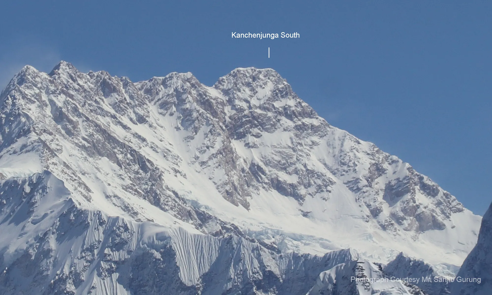
The five summits: Main 8,586 m · Yalung Kang (West) 8,505 m · South 8,494 m · Central 8,482 m · Kangbachen 7,903 m.
The Four Climbing Routes
There are four climbing routes to reach the summit of Kangchenjunga, three of which are in Nepal (from the southwest, northwest, and northeast) and one from northeastern Sikkim in India. The Indian government has banned expeditions on the Sikkim route since 2000, so in practice climbers today have three options — all from Nepal.
| Route | Side | Status | Notes |
|---|---|---|---|
| Southwest Face (Yalung) | Nepal | ● Open · Standard | The 1955 first-ascent route. ~95% of modern commercial expeditions use this line. |
| Northwest Face | Nepal | ● Open · Rare | Approached via Kangchen Glacier from the Ghunsa Valley. Less commercial traffic. |
| North Face / Northeast Spur | Nepal | ● Open · Rare | Used by the 1979 British North Ridge expedition. Technical and committing. |
| Northeast Route (Sikkim) | India | ○ Closed since 2000 | Used successfully only three times. Banned by the Indian government for religious reasons. |
Southwest Face / Yalung Face — The Standard Route
Approach: Fly Kathmandu → Bhadrapur → drive or fly to Taplejung / Suketar airstrip → trek 7–10 days through the Tamur Valley villages (Mitlung, Chiruwa, Sekathum, Amjilosa, Gyabla, Ghunsa, Khambachen) to Yalung Base Camp at approximately 5,500 m.
Route character: A 1955 line up the Yalung Glacier and the great rib that defines the southwest face. The route passes the Talung Saddle area and climbs onto the upper ramps below the summit pyramid. Mixed snow, ice, and rock at the higher camps.
Key challenge: Sustained exposure above Camp 4 (~7,500 m). The summit ridge traverse is long and the descent from the south summit area back to high camp is widely reported as one of the most fatiguing on any 8,000-meter peak. Many of the 43 recorded fatalities have occurred on this descent.
Used by: The 1955 first-ascent team, all commercial 8000-meter teams today (Madison Mountaineering, Seven Summit Treks, SummitClimb, Pioneer Adventures, Imagine Nepal).
Northwest Face — Kangchen Glacier Approach
Approach: Same trekking approach as the standard route via Ghunsa, but the climbing route ascends the Kangchen Glacier on the northwest side of the massif.
Route character: Technical mixed terrain with significant serac and avalanche exposure on the lower slopes. Higher camps follow snow ramps to the summit ridge.
Key challenge: Fewer fixed lines than the Yalung side; teams typically operate with greater self-sufficiency. Suitable only for expeditions with strong technical experience.
North Face / Northeast Spur
Approach: Nepal-side trek through the Ghunsa Valley with longer approach time to high base camp positions on the north side.
Route character: Used by the celebrated 1979 British North Ridge expedition (Doug Scott, Joe Tasker, Peter Boardman, Georges Bettembourg). Technical alpine-style climbing on committing mixed terrain.
Key challenge: Length, complexity, and the difficulty of retreat. Rarely attempted commercially.
Standard Route Camp Structure (Southwest Face)
Commercial expeditions typically establish four high camps above base camp. Exact elevations vary by team and conditions; the figures below reflect commonly reported positions.
Why the descent kills: Multiple fatalities on Kangchenjunga have occurred not on the summit push but on the descent from C4 to C2. Summit day on the southwest face typically takes 18–22 hours round trip, and climbers descend the long upper face in deteriorating weather and depleted physical state. Plan summit day energy for the return, not the top.
Permits, Fees & Logistics
Kangchenjunga falls under Nepal’s Department of Tourism expedition permit system. Permit fees were increased significantly effective September 1, 2025, with most 8,000-meter peaks (Kangchenjunga, Lhotse, Makalu) jumping from $1,800 to $3,000 in spring season.
| Item | Cost (USD) | Notes |
|---|---|---|
| Climbing permit — Spring (March–May) | $3,000 per climber | Most popular season; permit valid 55 days from issue |
| Climbing permit — Autumn (Sep–Nov) | ~$1,500 per climber | 50% discount vs. spring |
| Climbing permit — Winter (Dec–Feb) | ~$750 per climber | 75% discount; rarely attempted |
| Climbing permit — Monsoon (June–Aug) | ~$750 per climber | Effectively unclimbable in monsoon |
| Kanchenjunga Conservation Area permit | $25–30 per person | Issued by NPR; covers the trekking approach |
| Garbage deposit | $300–500 (refundable) | Refunded on proof of waste-out |
| Liaison officer | $2,500–5,800 per expedition | Government-assigned; mandatory above 8,000 m |
| NMA service fee (foreign) | NPR 2,000 | ~$15 USD |
| Insurance (climber + staff) | Variable | High-altitude rescue + medical mandatory |
| Full expedition cost (guided) | $25,000–55,000+ | Depends on operator, oxygen strategy, support level |
2025 regulation changes: Effective September 1, 2025, Nepal requires one guide per two climbers on all peaks above 8,000 m. Solo and alpine-style expeditions are no longer permitted. GPS tracking and biodegradable waste bags are mandatory. Death repatriation insurance with minimum NPR 5 million (~$37,500) coverage is required.
Best Time to Climb & Weather Windows
Kangchenjunga’s eastern Himalaya location makes its weather different from Everest. The mountain catches more eastern moisture and storms cycles can be longer. Spring remains the dominant climbing season.
| Season | Window | Conditions | Watch For |
|---|---|---|---|
| Spring | Late April – End of May | Best stable windows; ~95% of attempts | Storm cycles, heavy snowfall, serac risk on Yalung Face |
| Autumn | September – October | Fewer teams; shorter weather windows | Earlier winter storms, cold descents |
| Winter | December – February | Brutal cold and wind | Only experts attempt; Kukuczka/Wielicki style |
| Monsoon | June – August | Effectively unclimbable | Heavy snow, avalanche, low visibility |
The summit window on Kangchenjunga is typically narrower than Everest’s. Many expeditions get only a single 3–5 day window in late May, and teams that miss it often return empty-handed despite full base camp efforts.
Essential Gear Checklist
Kangchenjunga gear requirements match standard 8,000-meter expedition kit, but with extra emphasis on warmth (the eastern Himalaya is colder than Everest in equivalent positions) and on self-sufficiency given the remote setting.
High-Altitude Clothing
- 8000m down suit OR expedition parka + down pants (-40°C rated)
- Base layers (3 sets), heavyweight fleece, windproof shell
- Expedition mitts + liner gloves (3 pairs)
- Balaclava + buff + goggles (2 pairs, one summit-clear)
- Glacier sunglasses (Category 4)
Boots & Foot Systems
- 8000m triple boots (La Sportiva Olympus Mons, Millet Everest, Scarpa Phantom 8000)
- Mid-altitude double boots for rotations
- Crampons (anti-balling plates essential)
- Multiple sock systems with vapor barrier
- Insulated overgaiters
Technical Hardware
- Harness (full strength, large size for over down suit)
- Helmet (essential — serac fall on Yalung face)
- Ice axe + Whippet for descent
- Ascender + descender + 4 locking carabiners
- Prusik cords + 2 slings
Expedition & Comms
- Headlamp + 3 spare batteries (cold-rated)
- Personal first-aid + frostbite prevention
- Garmin inReach or satellite phone
- Power bank + solar panel for base camp
- GPS device (now mandatory per 2025 regulations)
Difficulty & Danger: Why Kangchenjunga Is So Serious
According to fatality data compiled by Alan Arnette, Kangchenjunga has recorded approximately 284 summits and 43 deaths — a 15.14% fatality rate. That places it firmly among the most dangerous 8,000-meter peaks alongside K2, Annapurna I, and Nanga Parbat. The risks compound from four factors:
1. Remoteness. The trekking approach from Suketar takes 7–10 days. There is no road, no village above Ghunsa, and no helicopter rescue option above ~6,500 m in poor weather. Rescue timelines can be 24–72 hours.
2. Length of summit day. 18–22 hour round trips from C4 are common. The summit ridge traverse is long and exposed. Many fatalities occur on the descent when fatigue and altitude impair decision-making.
3. Objective hazard. The Yalung face has significant serac and avalanche exposure between C2 and C3. The 1905 Crowley expedition lost climbers to an avalanche; recent seasons continue to see serac calving and slab releases.
4. Weather variability. Eastern Himalayan storm cycles can shut the mountain down for weeks. Summit windows are often 3–5 days versus Everest’s 7–10. Many teams come home without a summit.
Featured Expedition Operators
The list below covers established operators who advertise Kangchenjunga programs. Compare support ratios, oxygen strategy, rescue planning, and the operator’s record on the mountain (not just other 8000ers) before committing.
Madison Mountaineering
U.S.-based guiding company founded by Garrett Madison, with extensive 8000-meter operations. Madison runs full-service expeditions with experienced Western lead guides and Sherpa support. Their Kangchenjunga programs typically include oxygen, fixed lines, and full base camp logistics. madisonmountaineering.com
Seven Summit Treks
Kathmandu-based operator known for large-scale Himalayan logistics across all 14 eight-thousanders. They coordinate fixed-rope work on Kangchenjunga in spring season and offer multiple service tiers. Often the most operationally present team on the mountain. sevensummittreks.com
Imagine Nepal
Nepali-owned expedition operator that has run several successful Kangchenjunga programs in recent seasons. Strong reputation for high-altitude staffing and weather-window management. imaginenepaltreks.com
SummitClimb
International mountaineering company offering guided expeditions on major peaks worldwide. Smaller team sizes and structured itineraries; commonly compared on service inclusions and per-climber Sherpa ratios. summitclimb.com
Frequently Asked Questions
The permit alone is $3,000 in spring (post September 2025 fees). A guided commercial expedition typically costs $25,000–$55,000+ depending on operator, oxygen strategy, and support level. Add international flights, gear, insurance, and visa costs on top.
The historical fatality rate is approximately 15.14% (284 summits / 43 deaths per Alan Arnette’s data). That places Kangchenjunga among the most dangerous 8,000-meter peaks alongside K2, Annapurna I, and Nanga Parbat. Most fatalities occur on the descent, not the summit push.
6–8 weeks total. The trekking approach from Suketar to base camp takes 7–10 days. Acclimatization rotations and weather waits add 3–5 weeks at base camp. Summit pushes happen in late April through late May, and descent + trek out takes another week.
No — the Indian government banned all expeditions on the Sikkim (northeastern) route in 2000 for religious reasons. The Kangchenjunga massif on the Indian side is considered sacred, and the route remains closed today. The Khangchendzonga National Park became a UNESCO World Heritage Site in 2016.
When the British first-ascent team climbed in 1955, they agreed with Tashi Namgyal — the Chogyal (king) of Sikkim — that the highest point of the mountain would remain untrodden out of respect for its religious significance. Joe Brown and George Band stopped about 5 feet below the summit on 25 May 1955, and subsequent expeditions have continued this tradition.
Late April through end of May. Spring offers the most stable weather windows and is when ~95% of all attempts occur. Autumn (September–October) is possible but the windows are shorter and colder. Winter (December–February) and monsoon (June–August) are effectively reserved for elite alpinists.
The name comes from Tibetan: gangs-chen-mdzod-lnga. The Kangchenjunga massif’s five summits are said to represent five sacred treasures: salt; gold, turquoise and precious stones; sacred scriptures; invincible armor or ammunition; and grain and medicine. According to the Lhopo people of Sikkim, these treasures are hidden but reveal themselves to the devout when the world is in peril.
No. Kangchenjunga requires substantial prior 8000-meter experience. As of January 2025 regulations, Nepal increasingly requires climbers attempting peaks above 8,000 m to have previously summited a 7,000-meter peak in Nepal. Most operators require demonstrated experience on at least one prior 8000er (Everest, Manaslu, or Cho Oyu) plus serious technical credentials before considering Kangchenjunga.
Kangchenjunga Map & Live Weather
Kangchenjunga’s summit coordinates: 27°42’09″N 88°08’48″E (27.7025°N, 88.1467°E). The map below shows the summit location and the surrounding Kangchenjunga Himal — the Yalung Glacier feeds south into Nepal, while the Zemu Glacier drains east into Sikkim.
Was this helpful?
🏔Related peaks nearby
🧭Explore & compare
Global Summit Guide is an independent mountaineering resource founded in 2026. The team combines first-hand trekking and climbing experience with in-depth research and professional health and nutrition review to help climbers choose objectives, prepare properly, and stay safe.
Health, altitude, and nutrition content is reviewed by Taylor Ludlow (Registered Nurse) and Brigg Hoopes (Nutritionist).
What We Don't Know Yet
Mountain information changes quickly. This box explains the limits of what this page can responsibly promise.
- Permit availability, reservation windows, quotas, and official fee rules may change after this page is updated.
- Weather, snowpack, avalanche risk, road access, and route conditions can change quickly and may be different on your climbing dates.
- Route conditions, trailhead access, crevasse exposure, stream crossings, and rescue access may vary from published planning guidance.
- Gear requirements can change by season, route variation, weather window, personal cold tolerance, and guide-service requirements.
- Visa, passport, vaccination, border, insurance, and local transportation rules may change before your trip.
Verify current conditions with official land managers, guide services, local forecasts, and current route reports before booking or climbing.
Mountaineering, rock and ice climbing, glacier travel, and high-altitude activity are inherently dangerous and can result in serious injury or death. The information on Global Summit Guide is provided for general informational and educational purposes only and is not a substitute for professional instruction, qualified guiding, proper equipment, or your own judgment and experience.
Route conditions, weather, snowpack, permits, regulations, and hazards change constantly and may differ from what is described here. Details may be incomplete, out of date, or contain errors. Always verify current information with local authorities, certified guides, and official sources before making any decision in the mountains.
Nothing on this site is medical, legal, or financial advice. Our fitness, acclimatization, altitude, and nutrition content is general in nature; consult a qualified physician before beginning any strenuous exercise program or exposing yourself to high altitude.
You are solely responsible for your own safety and decisions. To the fullest extent permitted by law, Global Summit Guide and its team accept no liability for any loss, injury, damage, or expense arising from use of, or reliance on, this information. By using this site you acknowledge these risks and accept these terms.
Some links on this site may be affiliate links. If you buy through them we may earn a small commission at no extra cost to you; this never affects our recommendations.
Global Summit Guide recommendation path
Next Best Mountain to Research
Use these recommendations to continue the right planning path instead of stopping on one page.
Use current permit, weather, route, and operator information before booking or climbing.