<

Category: Regional Guides

  • Mountaineering in Mexico: a climber’s guide to the high volcanoes of the Trans-Mexican Volcanic Belt

    Mountaineering in Mexico: A Climber’s Guide to the High Volcanoes of the Trans-Mexican Volcanic Belt | Global Summit Guide
    Regional Climbing Guides / Mexico

    Mountaineering in Mexico: a climber’s guide to the high volcanoes of the Trans-Mexican Volcanic Belt

    5,636 m
    Pico de Orizaba (highest)
    4 peaks
    Climbable major volcanoes
    $800-$3.5K
    Trip cost range
    Nov-Mar
    Best season
    Part of the Mexico volcanoes series This regional guide supports our Mexico volcanoes master collection and connects all major Mexican peaks. Master guide →

    Mountaineering in Mexico is one of the most underrated high-altitude climbing experiences in the Americas. The country contains five major stratovolcanoes above 4,000 meters, with Pico de Orizaba at 5,636 m ranking as the third-highest peak in North America and the highest in Mexico. The volcanoes sit along the Trans-Mexican Volcanic Belt, all within a few hours’ drive of Mexico City — which makes Mexico one of the most logistically accessible high-altitude climbing destinations in the world. This guide covers the major peaks, when to climb them, costs, and the natural progression sequence that climbers actually use. For broader context see our Mexico volcanoes master collection.

    Why Mexico for mountaineering the underrated case

    Most international mountaineers headed for high-altitude experience in the Americas go directly to the Andes — Aconcagua, Cotopaxi, Huascarán, the Peruvian Cordillera Blanca. Mexico gets overlooked despite having mountains in the same elevation tier with several distinct advantages:

    • Direct access from major North American cities. Mexico City is a 3-5 hour flight from most US gateway cities. Compare this to 10-15 hours to Aconcagua’s gateway in Mendoza, Argentina.
    • No major permit costs. Mexican peaks have minimal park fees ($5-$20 per climber) compared to Aconcagua’s $800-$1,200 or Denali’s $400+ permits.
    • Compact peak cluster. The four climbable major peaks all sit within 2-3 hours of each other. Multi-peak trips are practical in 7-14 days.
    • Cost-effective guided climbing. Quality Mexican guide services charge $500-$1,500 for a 3-5 day Pico de Orizaba expedition — a fraction of equivalent guided trips in Argentina or Nepal.
    • Excellent acclimatization for harder peaks. The natural progression from La Malinche (4,461m) to Iztaccíhuatl (5,230m) to Pico de Orizaba (5,636m) provides world-class altitude preparation for Aconcagua, Denali, or Himalayan trekking peaks.
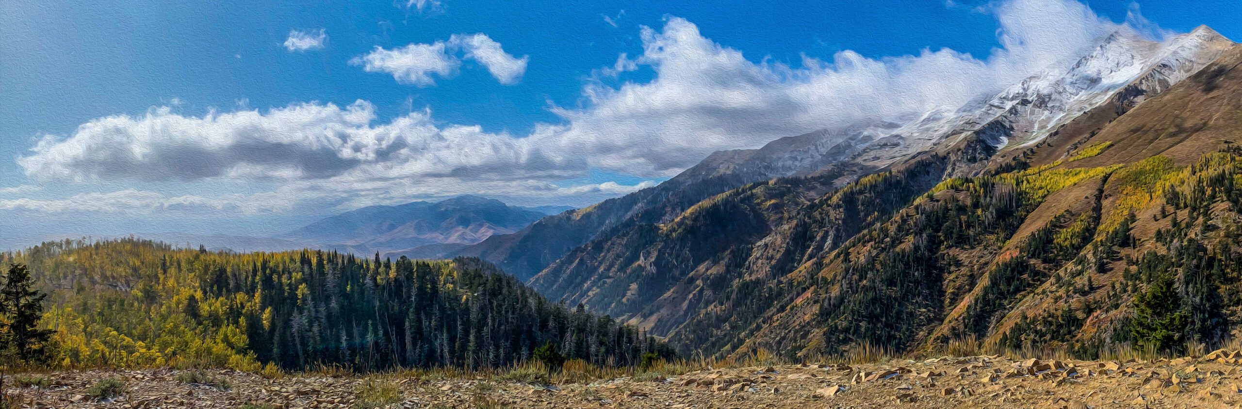
    • Dramatic volcanic terrain. The Trans-Mexican Volcanic Belt produces some of the most distinctive mountain scenery in the Americas — perfectly conical stratovolcanoes rising directly from agricultural plains.
    The use case that explains the Mexico volcanoes

    Mexico is where North American climbers go to graduate from intermediate to advanced. The progression from a Colorado 14er or Mount Rainier to Pico de Orizaba is the natural next step before Aconcagua or Denali. Mexican operators have built their entire industry around this progression — the climbing infrastructure is designed for North American mountaineers building skills, not for the casual hiker tourism that dominates Kilimanjaro or the trekking-focused industry of Nepal.

    The Trans-Mexican Volcanic Belt geography and geology

    Mexico’s high mountains are all volcanoes — specifically stratovolcanoes formed by the subduction of the Cocos Plate under the North American Plate along Mexico’s Pacific coast. The volcanoes are concentrated in a 900-kilometer east-west belt that crosses central Mexico from the Pacific Ocean near Puerto Vallarta to the Gulf of Mexico near Veracruz. This is the Trans-Mexican Volcanic Belt or Cordillera Neovolcánica — geologically distinct from the Sierra Madre ranges to the north and south.

    Geographic feature Detail
    Belt length~900 km east-west
    Highest pointPico de Orizaba (5,636 m)
    Number of major volcanoes5+ above 4,000 m
    Active eruptionsPopocatépetl (currently active)
    Tectonic originCocos Plate subduction
    Climbing access hubMexico City + Puebla + Tlachichuca
    Best seasonNovember – March (dry season)
    Climate typeTropical alpine

    The major climbable volcanoes peak by peak

    1

    Pico de Orizaba (Citlaltépetl)

    State: Puebla / Veracruz · Route: Jamapa Glacier (Normal) · Grade: PD · Duration: 3-5 days
    5,636 m

    The crown peak of Mexican mountaineering and the third-highest mountain in North America after Denali and Mount Logan. Pico de Orizaba is a perfect stratovolcano cone visible from much of central and eastern Mexico, with a permanent ice cap and the Jamapa Glacier on the upper mountain. The standard Normal Route via the Jamapa Glacier involves glacier travel with crampons and rope team, moderate elevation gain over 3-5 days, and requires full mountaineering equipment.

    Most climbers stage from Tlachichuca, the small town at the base of the mountain that has served as the climbing hub for over a century. From Tlachichuca, 4WD transport delivers climbers to the Piedra Grande hut at 4,260 m, with the summit attempt typically starting between midnight and 3 AM. The full Pico de Orizaba framework is in our Orizaba progression plan, with the route-specific detail in our Pico de Orizaba routes guide, gear list at Pico gear list, and difficulty assessment in our Pico difficulty and safety guide.

    2

    Iztaccíhuatl (Izta)

    State: México / Puebla · Route: Arista del Sol / La Joya · Grade: F+ / PD · Duration: 2-3 days
    5,230 m

    The “Sleeping Woman” volcano sits between Mexico City and Puebla, paired with the actively erupting Popocatépetl across a narrow valley. Iztaccíhuatl is a dormant volcano with five distinct summits along its long ridgeline, the highest being El Pecho (the chest). Unlike Pico de Orizaba, Iztaccíhuatl no longer has a true active glacier — climbers traverse rocky terrain and seasonal snow patches.

    The standard Arista del Sol route from La Joya trailhead involves moderate scrambling on volcanic rock and a long summit ridge traverse. Most climbers use the route as preparation for Pico de Orizaba, either climbing it directly before Orizaba for acclimatization or as a standalone introduction to 5,000-meter Mexican mountaineering. The route requires basic mountaineering skills but no technical climbing.

    ×

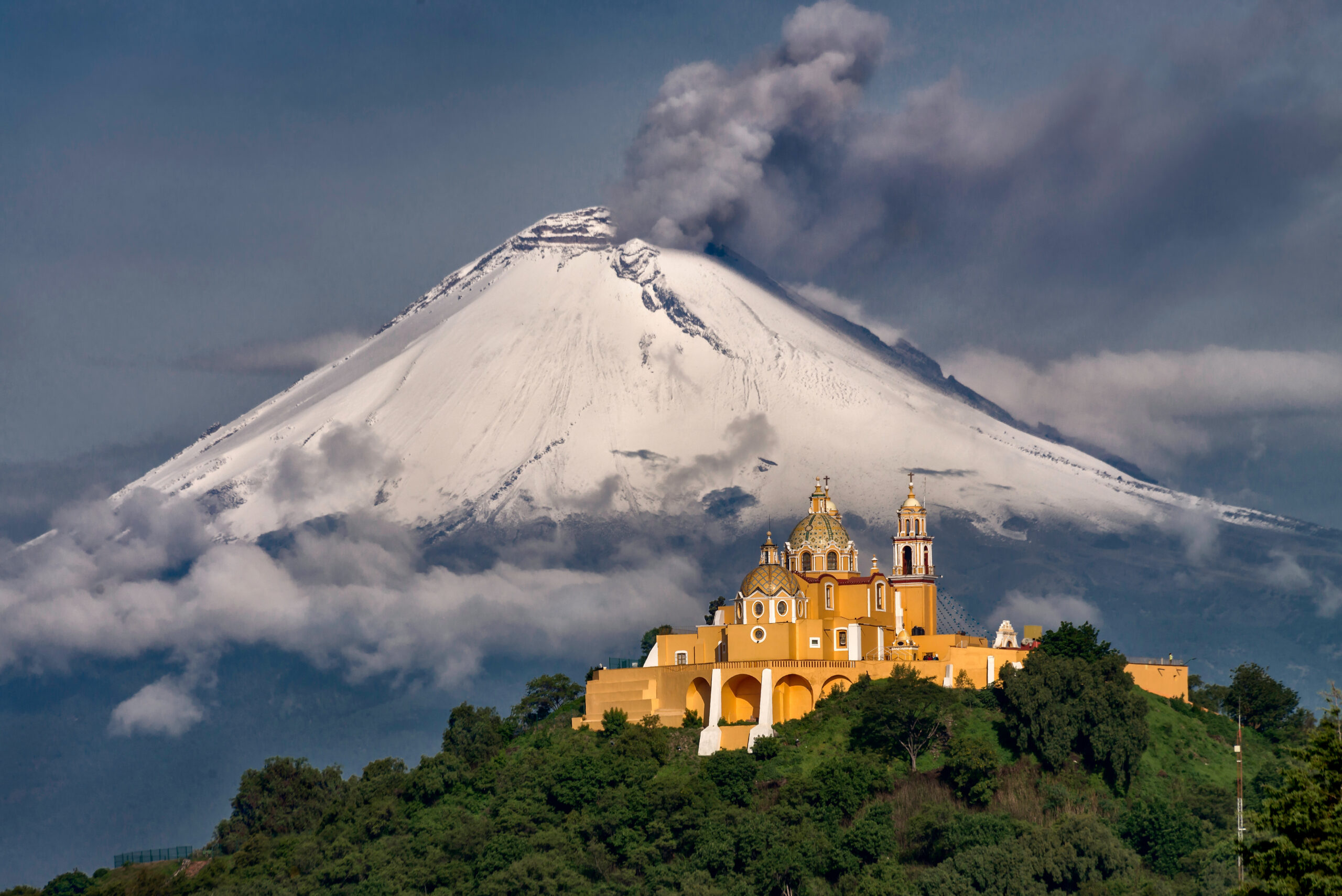
    Popocatépetl (Closed to Climbing)

    Status: Active eruption since 1994 · Currently: Climbing prohibited · Threat level: CENAPRED Yellow Phase 2
    5,426 m

    The second-highest peak in Mexico is currently closed to climbing due to ongoing volcanic activity. Popocatépetl (“Don Goyo” to locals) has been actively erupting since 1994 with regular ash emissions, occasional larger explosions, and sustained gas venting. CENAPRED, Mexico’s national emergency response center, maintains a 12-kilometer exclusion radius around the summit that explicitly prohibits climbing.

    The closure has been in effect for over three decades and shows no signs of being lifted. Climbers who research “Popocatépetl climbing” historically should understand that this is a closed objective — the mountain was a popular climb in the 1970s and 1980s but has not been open for legal climbing since the eruption activity began. Mexican authorities take the closure seriously; climbers caught inside the exclusion zone face fines and removal.

    3

    Nevado de Toluca (Xinantécatl)

    State: México · Route: Crater rim walk · Grade: F · Duration: Day hike
    4,680 m

    Nevado de Toluca is the fourth-highest peak in Mexico and one of the most accessible 4,000-meter volcanoes in the country. The volcano has a dramatic crater containing two lakes (Laguna del Sol and Laguna de la Luna) and a complete crater rim that can be walked in a long day. The road climbs to about 4,200 m, leaving only 480 m of vertical to the summit.

    The peak is technically non-technical hiking but the high altitude and exposed crater rim require fitness and weather awareness. Most climbers use Nevado de Toluca as a one-day acclimatization peak before Iztaccíhuatl or Pico de Orizaba. The volcano sits west of Mexico City and is closer to Toluca city, making it easy to combine with cultural visits to the Toluca area.

    4

    La Malinche (Matlalcuéyetl)

    State: Tlaxcala / Puebla · Route: Standard south slope · Grade: F · Duration: Day hike
    4,461 m

    La Malinche is the entry-level Mexican volcano and the standard first acclimatization peak for climbers preparing for the higher mountains. The volcano sits in the small state of Tlaxcala east of Mexico City and is climbed entirely as a day hike from the IMSS lodge at about 3,000 m. The standard route is a non-technical class 1-2 walk on a clear trail that takes 5-8 hours round trip.

    Most climbers use La Malinche as the first peak in a multi-volcano progression — typically arriving in Mexico, doing 1-2 acclimatization nights in Mexico City, then climbing La Malinche on day 3-4 before moving to higher peaks. The mountain is also climbed extensively by Mexican hikers from the surrounding region as a weekend objective.

    The Mexican high volcanoes of the Trans-Mexican Volcanic Belt showing the dramatic stratovolcano peaks that climbers attempt during the November to March climbing season including Pico de Orizaba Iztaccíhuatl La Malinche and Nevado de Toluca
    The Trans-Mexican Volcanic Belt produces some of the most distinctive mountain scenery in North America — perfectly conical stratovolcanoes rising directly from the central Mexican plains.

    The natural progression sequence how to actually structure a Mexico trip

    For climbers building toward Pico de Orizaba or just exploring Mexican mountaineering seriously, the typical progression spans 10-14 days and looks like this:

    Day Peak / Activity Elevation
    1-2Arrive Mexico City, acclimatization at 2,200-2,400 m2,200 m
    3-4La Malinche (acclimatization)4,461 m
    5Rest day in Cholula or Puebla2,100 m
    6-7Iztaccíhuatl (acclimatization + skills)5,230 m
    8-9Rest days in Tlachichuca or Mexico City2,400 m
    10-12Pico de Orizaba (summit attempt)5,636 m
    13-14Descent, return travelSea level

    This progression provides ideal altitude acclimatization for Orizaba and produces the highest summit success rates. Shorter trips (5-7 days) targeting Orizaba alone are possible but have meaningfully lower success rates because climbers arrive at the mountain inadequately acclimatized. Most experienced Mexico operators offer the full 10-14 day progression as their standard package.

    Cost framework for Mexico mountaineering honest budgeting

    Mexico is dramatically cheaper than equivalent peaks elsewhere in the Americas. The cost structure breaks down as follows:

    Trip type Typical cost (USD) What it includes
    La Malinche day climb (self-guided)$50-$150Park fee, transport, lodging
    La Malinche guided$150-$300Local guide, transport, lodging
    Iztaccíhuatl 2-day guided$300-$800Guide, lodge, summit attempt
    Pico de Orizaba 3-5 day guided$800-$2,500Guide, Piedra Grande hut, 4WD transport, summit attempt
    Full progression (10-14 days, guided)$2,500-$5,000All three peaks, lodging, transport, guides
    International flights to Mexico City$400-$1,500From US/Canada gateway cities
    Personal mountaineering gear$1,500-$3,000If buying new for Orizaba climb
    Total full trip cost$3,000-$7,50010-14 day expedition including flights
    The cost comparison that gets attention

    A full Mexican volcanoes expedition with three major peaks and English-speaking guide services costs roughly the same as Aconcagua’s permit fee alone. For climbers wanting high-altitude experience without expedition-tier budgets, Mexico is the answer.

    When to climb Mexican volcanoes season by season

    Period Conditions Recommendation
    November-DecemberExcellent — dry, stable, coolOptimal early season
    JanuaryBest window — coldest, driest, most stablePeak season for Orizaba
    FebruaryExcellent — late dry seasonOptimal continuing window
    MarchGood — last reliable dry monthExcellent end of season
    AprilTransitional — increasing stormsPossible but riskier
    May-OctoberRainy season — afternoon storms dailyAvoid for major peaks

    The Mexican rainy season from May through October produces near-daily afternoon thunderstorms in the mountains. While early-morning climbing is sometimes possible, the conditions are dramatically less reliable than the dry season. Lower peaks (La Malinche, lower Iztaccíhuatl) are sometimes climbed in summer, but Pico de Orizaba’s Jamapa Glacier becomes hazardous due to soft snow and increased rockfall during the rainy months.

    Logistics and access how to actually get there

    Mexico City International Airport (MEX) is the standard arrival point, served by direct flights from most US gateway cities. Some climbers fly into Puebla International Airport (PBC) which is closer to the eastern volcanoes (Orizaba, La Malinche) but has fewer flight options.

    Hub city Best for Distance from peaks
    Mexico CityAll peaks, main gateway2-3 hours to Izta, 4-5 hours to Orizaba
    PueblaOrizaba, Malinche, Izta1.5-3 hours to all peaks
    TlachichucaOrizaba (essential base)3-4 hours from base camp
    TolucaNevado de Toluca1 hour to summit road

    Major operators

    • Servimont Tlachichuca: the legendary Reyes family operation. Multi-generational guide service that has run Pico de Orizaba expeditions for decades. The original Pico Orizaba climbing base.
    • Summit Climb Mexico: international operator running scheduled departures with English-speaking guides.
    • Mountain Madness: US-based operator with established Mexican volcanoes programs.
    • Alpenglow Expeditions: California-based operator with periodic Mexican volcanoes trips.
    • Pico de Orizaba Tours: local Veracruz-based operator focused on the eastern approach.

    Safety considerations honest assessment

    • Altitude is the primary risk. Climbers move from Mexico City (2,400 m) to summits above 5,000 m within days. Proper acclimatization through the multi-peak progression is essential.
    • Volcanic activity at Popocatépetl. While Popocatépetl is closed to climbing, its proximity to Iztaccíhuatl means climbers should monitor CENAPRED alerts. Ash deposition can affect Izta climbs during eruptive episodes.
    • Glacier hazards on Pico de Orizaba. The Jamapa Glacier has crevasses and seasonal serac fall risk. Rope team travel is essential.
    • Weather windows can collapse quickly. Pacific moisture can produce unexpected storms even during the dry season. Early starts and weather awareness matter.
    • Driving safety in central Mexico. Standard precautions apply — daytime driving on main highways, avoid driving in rural areas after dark, use established operators for transport rather than self-driving rental cars to remote trailheads.
    • Travel insurance: the framework for high-altitude trekking insurance is in our mountain climbing insurance decision framework.

    Mexico vs the Andes honest comparison

    Dimension Mexican volcanoes Andean equivalents (Ecuador/Peru/Bolivia)
    Highest peakPico de Orizaba 5,636 mChimborazo 6,263 m / Huascarán 6,768 m
    Number of major peaks4 (climbable)15+ above 5,500 m
    Access from North America3-5 hour flight8-12 hour flight + connections
    Permit costsMinimal ($5-$20)Variable, often $100-$300
    Guide service cost$500-$1,500 (Orizaba)$1,500-$3,500 (Chimborazo)
    Total expedition cost$3,000-$7,500$4,000-$10,000
    Cultural environmentMexico City, Puebla, TlachichucaQuito, Cusco, La Paz
    Acclimatization for Aconcagua/DenaliExcellent foundationSlightly better (higher peaks)
    Technical climbing varietyLimited (mostly snow plods)Wider variety, technical options

    Mexico wins on access, cost, and convenience. The Andes win on peak variety, technical options, and absolute altitude. For climbers prioritizing efficient progression and cost-effective acclimatization, Mexico is the right choice. For climbers wanting the deepest possible high-altitude experience or technical objectives, the Andes still hold the advantage.

    Who should climb the Mexican volcanoes honest fit assessment

    Mexico is excellent for you if…

    • You’re a North American climber wanting high-altitude experience without long international travel
    • You’re preparing for Aconcagua, Denali, or Himalayan trekking peaks and need acclimatization
    • You want to graduate from US 14ers / Mount Rainier to international expeditions
    • You appreciate cost-effective guided climbing without sacrificing safety
    • You enjoy multi-peak progressions in a compact geographic area
    • You’re interested in Mexican culture and want to combine climbing with cultural travel

    Mexico might not fit if…

    • You want technical climbing — Mexican volcanoes are mostly snow plods, not technical objectives
    • You want extreme altitude (6,000+ m) — only Aconcagua, Andes, or Himalaya provide this
    • You strongly prefer Spanish/cultural immersion in South America specifically
    • You want the absolute highest peaks in the Americas — Aconcagua and Denali are higher
    ★ Mexico Volcanoes Master Resources

    The complete Mexico mountaineering framework

    Detailed peak profiles, route guides, costs, and the broader Trans-Mexican Volcanic Belt context.

    Master collection →

    The bottom line on mountaineering in Mexico

    Mountaineering in Mexico is one of the most underrated high-altitude climbing experiences in the Americas. The Trans-Mexican Volcanic Belt contains four climbable major volcanoes ranging from La Malinche at 4,461 m (entry-level day hike) to Pico de Orizaba at 5,636 m (the third-highest peak in North America requiring full mountaineering equipment). Popocatépetl at 5,426 m is closed due to ongoing volcanic activity. The country offers exceptional value compared to Andean alternatives: dramatically lower costs, easier access from North America, no major permit fees, and a compact peak cluster that allows efficient multi-peak progressions in 10-14 days. The natural sequence — La Malinche to Iztaccíhuatl to Pico de Orizaba — provides world-class acclimatization for climbers preparing for Aconcagua, Denali, or Himalayan trekking peaks. Best season is November through March, with December-February producing the most stable conditions for Orizaba’s Jamapa Glacier. For North American climbers building toward serious mountaineering, Mexico is the natural next step after Mount Rainier or Colorado 14ers. The full Mexico mountaineering framework is in our Mexico volcanoes master collection, with detailed Pico de Orizaba content in our Orizaba progression plan, routes guide, gear list, and difficulty assessment.

    Frequently asked questions

    What are the highest mountains in Mexico?

    The highest mountains in Mexico are all stratovolcanoes located along the Trans-Mexican Volcanic Belt that crosses central Mexico east to west. Pico de Orizaba (Citlaltépetl) at 5,636 meters is the highest peak in Mexico and the third-highest in North America. Popocatépetl at 5,426 meters is the second-highest, but is closed to climbing due to active eruptions. Iztaccíhuatl at 5,230 meters is the third-highest and the most-climbed major volcano. Nevado de Toluca at 4,680 meters and La Malinche at 4,461 meters round out the major Mexican peaks for climbers.

    Is mountaineering popular in Mexico?

    Mountaineering in Mexico has a strong domestic following and an emerging international following. Mexican climbers have used the high volcanoes as training grounds for major expeditions for decades, and the country has produced notable mountaineers. International mountaineering tourism is smaller than in Peru or Ecuador but growing, driven primarily by climbers seeking high-altitude acclimatization for Aconcagua or Denali. The volcanoes are increasingly popular as cost-effective alternatives to Andean peaks of similar elevation, with lower permit costs and easier logistics for North American climbers.

    How difficult are the Mexican volcanoes to climb?

    The Mexican volcanoes range from easy hiking peaks to serious high-altitude mountaineering objectives. La Malinche at 4,461 meters is a non-technical day hike accessible to fit hikers. Nevado de Toluca at 4,680 meters is also non-technical but at higher altitude. Iztaccíhuatl at 5,230 meters involves moderate scrambling and route-finding plus high-altitude acclimatization. Pico de Orizaba at 5,636 meters requires full mountaineering equipment, glacier travel skills, and serious acclimatization – it is comparable in difficulty to a guided Aconcagua attempt or the standard Denali route in summer conditions. Popocatépetl is closed to climbing due to active volcanic activity.

    What is the best time to climb Mexican volcanoes?

    The best season for climbing Mexican volcanoes is from November through March, with December and January being the most stable months. This is the dry season in central Mexico, producing the most reliable weather and the most consistent snow conditions on the highest peaks. The rainy season from May through October produces frequent afternoon thunderstorms that make summit attempts risky. Pico de Orizaba in particular has its strongest conditions from December through February. April and October are shoulder seasons that can be excellent but unpredictable. Most international expeditions schedule trips for December through February for maximum success probability.

    How much does it cost to climb in Mexico?

    Mountaineering in Mexico is dramatically cheaper than equivalent peaks in the Andes or Alps. A typical Pico de Orizaba expedition costs 1,200 to 3,500 USD including local guide service, transport, and accommodation, plus international flights. Iztaccíhuatl trips cost 800 to 2,000 USD. Combination trips climbing multiple peaks (Malinche + Iztaccíhuatl + Orizaba over 10-14 days) cost 2,500 to 5,000 USD typically. International flights to Mexico City add 400 to 1,500 USD depending on origin. There are no significant permit fees for Mexican peaks – only basic park access fees of a few dollars per climber per day.

    Do I need a guide to climb Mexican volcanoes?

    You technically do not need a guide for most Mexican volcanoes, but most international climbers use one. La Malinche and Nevado de Toluca are commonly climbed without guides by experienced hikers. Iztaccíhuatl is often climbed self-guided by experienced mountaineers, though guides improve safety and success rate. Pico de Orizaba is almost universally climbed with a guide due to glacier travel requirements, altitude, and route-finding complexity on the Jamapa Glacier. Local Mexican guide services in Tlachichuca and Hidalgo offer excellent value at 500 to 1,500 USD for a 3-5 day Orizaba expedition – significantly less than equivalent guided services elsewhere.

    Are Mexican volcanoes good for acclimatization?

    Yes, the Mexican volcanoes are widely used as acclimatization for major Andean and Alaskan peaks. The progression from La Malinche (4,461m) to Nevado de Toluca (4,680m) to Iztaccíhuatl (5,230m) to Pico de Orizaba (5,636m) provides a structured altitude progression in a compact 10-14 day trip. Climbers preparing for Aconcagua, Denali, or Himalayan trekking peaks often use this Mexican volcanoes sequence as a final pre-expedition acclimatization. The combination of accessible altitude, cost-effective logistics, and the variety of peaks makes Mexico one of the best acclimatization regions in the Americas.

  • Mountains in Utah: a climber’s guide to the Wasatch, Uintas, and Utah’s greatest peaks

    Mountains in Utah: A Climber’s Guide to the Wasatch, Uintas, and Utah’s Greatest Peaks | Global Summit Guide
    Regional Guides / Utah

    Mountains in Utah: a climber’s guide to the Wasatch, Uintas, and Utah’s greatest peaks

    13,528 ft
    Kings Peak (highest)
    7+
    Major ranges
    200+
    Named peaks 11K ft+
    Jul-Sep
    Best climbing season
    Part of the Utah mountains series This climber’s guide supports our best mountains in Utah master guide and connects to our Utah-specific peak content. Master guide →

    Utah is one of the most underrated mountain states in the US. The state has over 200 named peaks above 11,000 feet distributed across 7+ major ranges, the highest summit (Kings Peak) reaching 13,528 feet, and a combination of Wasatch alpine terrain, Uinta high country, and southern Utah desert peaks that no other state matches. Despite this, Utah’s mountains attract less national attention than Colorado’s 14ers or California’s Sierra Nevada — which is exactly what makes them appealing for climbers seeking fewer crowds and more variety. This guide covers the major Utah ranges, the most important peaks in each, and the order most climbers approach them. For broader context see our best mountains in Utah master guide.

    Utah’s mountain geography an overview

    Utah sits at the intersection of the Rocky Mountains, the Colorado Plateau, and the Great Basin, producing one of the most geologically diverse mountain landscapes in the United States. The state has three distinct mountain regions:

    • The Wasatch Front and Range: the north-south spine running from southern Idaho through Salt Lake City to central Utah. Contains the most-climbed peaks due to population proximity.
    • The Uinta Mountains: the unusual east-west range in northeastern Utah. Contains all of Utah’s highest peaks and the state’s only “13ers” (peaks above 13,000 feet).
    • The southern Utah ranges: the La Sal Mountains near Moab, the Henry Mountains, the Abajo Mountains, the Tushar Mountains, and others. Desert mountain character with dramatic views and lower visitor numbers.
    The mountains of Utah showing the Wasatch Range and Uinta Mountains landscape with high alpine terrain dramatic ridges and the diverse mountain geography that defines Utah climbing
    Utah’s diverse mountain landscape spans the Wasatch Front, the Uinta high country, and the southern desert ranges — over 200 named peaks above 11,000 feet across seven major mountain ranges.

    The diversity is what makes Utah unique. A climber based in Salt Lake City can spend the morning on a Wasatch Range scramble, drive 90 minutes east to backpack into the Uintas for a multi-day high peak, or drive 4 hours south to climb a desert mountain in the La Sals — all without leaving the state. No other state has this range of mountain experience packed so close together.

    Utah’s highest peaks the headline mountains

    1

    Kings Peak

    Uinta Mountains · Highest point in Utah · 28-mile backpack round trip · Class 2 scrambling at summit
    13,528 ft

    Kings Peak in the Uinta Mountains is the high point of Utah and one of the more unusual US state high points — it requires a 28-mile round-trip backpacking trip rather than a single-day hike. The peak sits deep in the High Uintas Wilderness with no road access closer than the Henrys Fork trailhead, 14 miles from the summit. Most climbers complete Kings Peak as a 3-day backpack, though strong parties can complete it in 2 days. The summit ridge involves class 2 scrambling on talus and is the highest peak in the entire Uinta Mountains range.

    2

    Mount Peale

    La Sal Mountains · Highest peak in southern Utah · Near Moab · Class 2 scramble
    12,726 ft

    Mount Peale in the La Sal Mountains is the highest peak in southern Utah and the second-highest peak in the state. The mountain sits in the La Sals range east of Moab, providing dramatic high alpine terrain rising from the surrounding red rock desert. Most climbers approach via the standard route from the La Sal Loop Road. The peak is class 2 with talus scrambling at the summit ridge and is meaningfully easier than Kings Peak due to a shorter approach and better trailhead access.

    3

    Mount Nebo

    Southern Wasatch Range · Highest peak in Wasatch · Multi-summit massif · Class 2 standard
    11,933 ft

    Mount Nebo is the highest peak in the Wasatch Range and the southernmost peak of the main Wasatch chain. The mountain is technically a three-summit massif with the south summit being the highest, though the north summit and middle summit are also recognized peaks. The standard route is class 2 with a long approach hike from the Wasatch foothills. Mount Nebo’s location makes it less visited than the Salt Lake City peaks but the dramatic three-summit profile and high elevation make it one of the iconic Utah objectives.

    The Wasatch Range the iconic peaks

    The Wasatch Range is Utah’s most visited mountain range, running north-south through northern Utah from the Idaho border to central Utah. The Wasatch Front (the western edge of the range visible from Salt Lake City and Provo) is one of the most populated mountain edges in the US. The peaks east of Salt Lake City — Mount Olympus, Twin Peaks, Lone Peak — are climbed by tens of thousands of locals each year.

    Mount Timpanogos is the most-climbed mountain in Utah, with over 100,000 attempts annually on the standard Aspen Grove and Timpooneke trails. The mountain dominates the skyline above Utah Valley and produces dramatic views from Provo, American Fork, and Lehi. The hike is a long day (14 miles round trip) with significant elevation gain but is class 2 throughout and accessible to fit hikers. The mountain has a small glacier (the “Timpanogos Glacier” — actually more accurately a permanent snowfield) near the summit.

    Mount Olympus is the most prominent peak in the Salt Lake Valley, rising directly above the city’s east bench. Despite being lower than many Utah peaks (9,026 ft), it is one of the steepest hikes in Utah — 4,100 feet of gain in just 4 miles round trip. The upper section includes class 3 scrambling on rock. Mount Olympus is the standard “test piece” for new Salt Lake hikers and the most-summited Wasatch peak by per-capita measure.

    Lone Peak is one of the most technically demanding Wasatch peaks accessible from Salt Lake. The standard hike to the summit involves a long approach through the granite cirque, with class 3-4 scrambling on the upper mountain. The cirque itself contains some of the best granite climbing in the Wasatch and is a popular technical climbing destination. The hike to the summit is widely considered one of the hardest day hikes in Utah.

    Twin Peaks (also called Broads Fork Twin Peaks) is one of the most dramatic-looking peaks visible from Salt Lake City. The standard route via Broads Fork involves a long approach hike with class 3 scrambling on the upper section. The summit views encompass the entire Salt Lake Valley to the west and the Cottonwood Canyons high country to the east.

    Utah mountain peaks in the Wasatch and Uinta ranges showing the alpine terrain dramatic ridgelines and high country that defines Utah's climbing landscape from Mount Timpanogos to Kings Peak
    From Mount Timpanogos in the Wasatch to Kings Peak in the Uintas, Utah’s peaks span dramatic alpine terrain accessible within driving distance of Salt Lake City and Provo.

    The Uinta Mountains Utah’s high country

    The Uinta Mountains are one of the most unusual major ranges in the contiguous United States — they run east-west rather than north-south, which is unique among major American ranges. The Uintas contain all of Utah’s 13ers (peaks above 13,000 feet), and the High Uintas Wilderness is one of the largest wilderness areas in the lower 48 states. Most Uinta peaks require multi-day backpacking trips due to limited road access into the range.

    1

    Kings Peak

    Henrys Fork trailhead · Utah’s state high point · 28-mile round trip backpack
    13,528 ft
    2

    South Kings Peak

    Adjacent to Kings Peak · Combined climbing day · Class 2
    13,512 ft
    3

    Gilbert Peak

    Western Uintas · Long approach · Class 2 scramble
    13,442 ft
    4

    Mount Emmons

    Central Uintas · Multi-day backpack · Class 2
    13,440 ft
    5

    Mount Lovenia

    Central Uintas · Remote · Class 2-3
    13,219 ft

    The Uintas have 17-19 named peaks above 13,000 feet depending on how subsidiary summits are counted. Climbing all of them is a multi-year project for serious Utah climbers — the remote access and limited windows of good weather make Uinta peak bagging a significantly different undertaking than Wasatch hiking. The full Kings Peak detail is in our existing Utah content.

    The Uintas character

    The High Uintas have a feel unlike anywhere else in Utah — broad alpine basins, hundreds of lakes, vast tundra plateaus, and peaks rising from already-high terrain. The trade-off is that the range is genuinely remote. You will not see another person for days in many parts of the High Uintas Wilderness, but you also cannot rely on rescue capability anywhere comparable to the Wasatch or Colorado 14ers.

    Southern Utah ranges desert mountain country

    The southern half of Utah contains several smaller but visually dramatic mountain ranges that contrast sharply with the surrounding red rock desert. These are the most photogenic mountains in Utah and produce some of the most striking landscapes anywhere in the American West.

    1

    Mount Peale

    La Sal Mountains, near Moab · Class 2 · High alpine terrain over red rock desert
    12,726 ft
    2

    Mount Mellenthin

    La Sal Mountains · Adjacent to Mount Peale · Combined climbing day · Class 2
    12,646 ft
    3

    Mount Tukuhnikivatz

    La Sal Mountains · Iconic Moab skyline peak · Class 2-3
    12,482 ft
    4

    Mount Ellen

    Henry Mountains · Most remote major peak in the lower 48 · Class 2
    11,522 ft
    5

    Delano Peak

    Tushar Mountains · South-central Utah · Class 1-2
    12,174 ft

    The Henry Mountains deserve special mention — they were the last named mountain range in the lower 48 United States, mapped only in the 1870s. Mount Ellen and the rest of the Henry Mountains are among the most remote major peaks in the country and offer climbers a meaningfully different experience than the more developed Wasatch and La Sals.

    Utah mountains compared to other Western states

    State Highest peak Named 14ers vs Utah character
    UtahKings Peak 13,528 ft0Diverse — Wasatch + Uintas + desert
    ColoradoMt Elbert 14,440 ft58Higher concentration of major peaks, but less variety
    CaliforniaMt Whitney 14,505 ft12Higher peaks, longer approaches, Sierra Nevada granite
    WyomingGannett Peak 13,810 ft0Wind River Range, more remote
    New MexicoWheeler Peak 13,167 ft0Sangre de Cristo southern terminus
    ArizonaHumphreys Peak 12,633 ft0Single major range (San Francisco Peaks)
    NevadaBoundary Peak 13,140 ft0Basin and Range character

    Utah does not have the highest peaks (Colorado, California, Wyoming all have higher summits) and does not have 14ers. But Utah’s combination of accessible Wasatch peaks, remote Uinta high country, and southern Utah desert mountains provides a variety of mountain experience that no other state matches. The full broader Western state context is in our best mountains in the USA guide.

    When to climb Utah mountains seasonal framework

    Season Wasatch peaks Uinta peaks Southern Utah ranges
    March-AprilSnow on high terrainClosed (deep snow)Approaching season
    MaySnow lingers above 9,000 ftStill closedExcellent (cool desert)
    JuneSnow patches retreatingSnow still extensiveHot in lower elevations
    JulyPrime seasonStandard season opensHot but accessible
    AugustPrime seasonPrime seasonBest for high La Sals/Henrys
    SeptemberExcellent — fewer crowdsExcellent — best windowExcellent
    OctoberFirst snow possibleSnow returnsCooler, excellent
    Nov-FebWinter mountaineeringClosedWinter desert climbing

    The single biggest seasonal factor in Utah is the Uintas — they have a meaningfully shorter climbing season than the Wasatch or southern ranges because of the higher base elevation and east-west orientation that holds snow longer. Late July through mid-September is the reliable window for Uinta high peaks. The Wasatch can be climbed earlier and later, and southern Utah peaks are often best in spring and fall when high-country routes are too snowy. The full Wasatch winter context is in our existing Kings Peak content.

    Who Utah mountains are good for honest fit assessment

    Utah is excellent for you if…

    • You live in or visit Salt Lake City, Provo, or the Wasatch Front and want frequent mountain access
    • You enjoy mountain variety — alpine, high country, desert peaks all within driving distance
    • You appreciate less crowded peaks than Colorado 14ers or California Sierras
    • You can backpack for multi-day Uinta objectives
    • You want to combine mountain trips with Utah’s national parks (Zion, Bryce, Arches, Canyonlands)
    • You are interested in winter mountaineering — the Wasatch has world-class backcountry skiing and ski mountaineering

    Utah might not fit if…

    • Your primary goal is 14ers — go to Colorado instead
    • You want technical alpine climbing — California Sierra granite or Cascade volcanoes are better matches
    • You strongly prefer single-day peak access without multi-day trips
    • You want lots of guided commercial expedition options — Utah’s guide service density is lower than Colorado or California

    A Utah mountain progression how climbers typically approach the state

    For climbers building toward Utah peak bagging or just exploring Utah’s mountains seriously, the typical progression looks like this:

    1. Year 1 — Wasatch Front intro: Mount Olympus, Mount Wire, Twin Peaks (the Pfeifferhorn variant). Build comfort with Wasatch-style steep hiking.
    2. Year 1-2 — Mount Timpanogos: the standard Utah peak. Test fitness on a long Wasatch day.
    3. Year 2 — Lone Peak and Mount Nebo: harder Wasatch objectives. Class 3-4 scrambling, longer days, real route-finding.
    4. Year 2-3 — First Uinta backpack: Kings Peak as the introduction to multi-day Uinta climbing. The state high point in 2-3 days.
    5. Year 3+ — Uinta 13er project: systematic Uinta high peaks. Most climbers complete this over 3-5 years of summer backpacking trips.
    6. Year 3+ — Southern Utah peaks: Mount Peale, Mount Mellenthin, Mount Ellen. Combine with national park trips.
    7. Winter mountaineering: Wasatch backcountry skiing and ski mountaineering as a winter complement to summer hiking.
    A note on Utah technical climbing

    Beyond hiking and peak bagging, Utah is one of the best technical climbing destinations in the world. Indian Creek splitter cracks, Zion big walls, Wasatch granite cirques, and the Castle Valley desert towers near Moab represent some of the best rock climbing anywhere. Climbers seriously building toward technical alpinism often spend time in Utah for the rock climbing as well as the peak bagging.

    Getting to Utah mountains practical access

    Destination Driving from Time
    Wasatch Front peaksSalt Lake City15-45 min
    Mount TimpanogosSalt Lake City1 hour
    Mount NeboSalt Lake City1.5 hours
    Uintas (Henrys Fork)Salt Lake City2.5-3 hours
    La Sal MountainsMoab30-45 min
    La Sals from Salt LakeSalt Lake City4 hours
    Henry MountainsSalt Lake City4.5 hours
    Tushar MountainsSalt Lake City3 hours

    Salt Lake City International Airport (SLC) is the standard arrival point for Utah climbing trips, with rental cars and direct access to the Wasatch Front. Many Utah peaks can be climbed as day trips from Salt Lake, though the Uintas and southern ranges typically require longer trips. The Utah Department of Transportation maintains good road access to most major trailheads year-round, though high-elevation roads close in winter.

    ★ Utah Mountains Master Guide

    The full Utah mountain framework

    Detailed peak profiles, route guides, and the complete framework for climbing in Utah.

    Master guide →

    The bottom line on Utah mountains

    Utah has over 200 named peaks above 11,000 feet distributed across seven major mountain ranges, including all 17-19 of the state’s “13ers” in the Uinta Mountains and the iconic Wasatch peaks accessible from Salt Lake City and Provo. Kings Peak at 13,528 feet is the state high point. Mount Timpanogos is the most-climbed peak. Mount Olympus is the most visible from population centers. The state combines Wasatch alpine terrain, Uinta high country, and southern Utah desert peaks in a way no other state matches. While Utah lacks 14ers and the absolute highest peaks belong to Colorado and California, the variety, accessibility, and lower visitor numbers make Utah one of the most rewarding mountain states for climbers who appreciate diverse mountain experience over pure altitude. The full peak-by-peak framework is in our best mountains in Utah master guide.

    Frequently asked questions

    What is the highest mountain in Utah?

    Kings Peak in the Uinta Mountains is the highest mountain in Utah at 13,528 feet (4,123 meters). Kings Peak is the high point of the entire Uinta Mountains range and one of only a handful of US state high points that requires a multi-day backpacking trip rather than a single-day hike. Mount Peale in the La Sal Mountains near Moab at 12,726 feet is the second-highest peak in Utah. The Uinta Mountains contain Utah’s highest peaks while the Wasatch Range contains the most-visited peaks due to proximity to Salt Lake City.

    What are the main mountain ranges in Utah?

    Utah has several major mountain ranges: the Wasatch Range (running north-south through northern Utah, containing peaks like Mount Timpanogos and Mount Nebo and the Salt Lake City area mountains), the Uinta Mountains (running east-west in northeastern Utah, containing Kings Peak), the La Sal Mountains (near Moab in southeast Utah), the Henry Mountains (south-central Utah), the Abajo Mountains (southeastern Utah), the Tushar Mountains (south-central Utah), and several smaller ranges. The Wasatch is the most populated and accessed, while the Uintas contain the highest peaks.

    What is the most famous mountain in Utah?

    Mount Timpanogos in the Wasatch Range at 11,752 feet is widely considered the most famous mountain in Utah, with over 100,000 hikers attempting it annually. The mountain is visible from much of Utah Valley and is the dominant peak in the Provo area. Mount Olympus near Salt Lake City is also extremely well known due to its prominence above the Salt Lake Valley. Kings Peak is famous as the state high point but is less visited due to its remote location. Mount Nebo at 11,933 feet is the highest peak in the Wasatch Range and a popular climbing objective.

    How many mountain peaks are in Utah?

    Utah has thousands of named mountain peaks across its various ranges. Counts depend on the inclusion criteria, but Utah has approximately 18 named peaks above 13,000 feet (all in the Uinta Mountains) and over 200 named peaks above 11,000 feet across the Wasatch, Uintas, and other ranges. The Wasatch Range alone contains over 50 named peaks above 10,000 feet. Mountain peak counts in Utah are dominated by the Uinta Mountains for highest elevation peaks and the Wasatch for total number of significant climbing objectives.

    Are there 14ers in Utah?

    No, Utah does not have any 14ers (peaks above 14,000 feet). The highest peak in Utah, Kings Peak in the Uinta Mountains, is 13,528 feet — just shy of the 14,000-foot threshold. Utah does have 13ers (peaks above 13,000 feet) — all of them located in the Uinta Mountains. The 14er distinction belongs primarily to Colorado (58 peaks), California (12 peaks), and Alaska. Utah’s high peaks are typically classified as 13ers and 12ers, with the Uintas containing all the 13ers and the Wasatch and southern ranges containing most of the 12ers.

    What is the best mountain to climb in Utah?

    The best mountain to climb in Utah depends on your goals. For most hikers, Mount Timpanogos in the Wasatch Range is the best Utah peak — accessible from Salt Lake City and Provo, dramatic terrain, and good views. For peak baggers, Kings Peak as the state high point is the iconic Utah objective. For a quick mountain day near Salt Lake City, Mount Olympus offers steep accessible hiking. For technical climbers, the granite walls of Lone Peak and the Cottonwood Canyons offer significant climbing. Each peak serves different climber profiles.

    When is the best time to climb mountains in Utah?

    The best time to climb most Utah mountains is July through early October. Snow lingers in the high country (Uintas, upper Wasatch) until late June or July in most years. The peak hiking season is July-August with stable weather and mostly dry conditions, though afternoon thunderstorms are common. September often produces the most stable weather and fewer crowds. Lower-elevation peaks in southern Utah (La Sals, Henry Mountains) have longer seasons. Winter mountaineering in Utah is significant, particularly in the Wasatch Range backcountry.

  • Mountains near Denver: a hiker’s guide to the Front Range and closest peaks

    Mountains Near Denver: The Hiker’s Guide to the Front Range and Closest Peaks | Global Summit Guide
    Regional Guides / Colorado

    Mountains near Denver: a hiker’s guide to the Front Range and closest peaks

    14,265 ft
    Mount Evans / Blue Sky
    ~75 min
    Closest 14er drive
    200 mi
    Front Range length
    10+
    14ers within 2 hrs
    Part of the Colorado mountains series This Denver-area guide supports our best mountains near Denver master guide and our complete Colorado 14ers guide. Master guide →

    Denver sits at 5,280 feet, calls itself the Mile High City, and looks out on roughly 200 miles of Front Range mountains visible on most clear days. That kind of access is unusual — no other major US city has dozens of named peaks, multiple 14ers, and a national park all within a two-hour drive. This guide answers the questions Denver-area hikers and visitors actually ask: which mountains can you see from the city, what is the closest 14er, where do you start if you are new to Colorado peaks, and what are the best day-hike objectives within 2 hours of downtown. For the deeper deep-dive on individual peaks, see our best mountains near Denver master guide and our complete Colorado 14ers guide.

    What mountains can you see from Denver

    On any clear day, the western horizon from Denver shows a continuous wall of mountains stretching from north to south, technically the Front Range of the Rocky Mountains. From downtown you can identify roughly 30 named peaks if you know what you are looking for. The most prominent visible peaks, north to south:

    The best Denver-area viewpoints for seeing the mountains are Lookout Mountain in Golden (a 30-minute drive from downtown that puts you directly above the city looking west), Sloan Lake just northwest of downtown, Mount Falcon Park, and the upper floors of downtown buildings facing west. The clearest viewing days are typically after weather systems pass through and clear the air, particularly the morning after rain or snow when haze drops to near zero.

    The viewing reality from downtown

    The peaks visible from Denver are not as close as they look. Mount Evans appears to loom right over the city but is actually 35 miles west. Longs Peak is 50 miles northwest. The apparent closeness is an optical effect of the dry mountain air and the height of the peaks above the surrounding terrain. The mountains are real, they are accessible, but they take 1 to 2 hours of driving to actually reach.

    The closest mountains to Denver

    Different definitions of “closest” produce different answers. If you mean closest named mountain by drive time, Lookout Mountain wins. If you mean closest meaningful mountain experience, the foothills peaks west of Golden and Evergreen are 30-45 minutes from downtown. If you mean closest 14er (peak above 14,000 feet), Mount Bierstadt and Mount Evans tie at roughly 75 minutes. Here are the closest peaks in each category:

    1

    Lookout Mountain (Golden)

    The closest named mountain · Drive-up via Lariat Loop · Easy walking trails · Buffalo Bill Museum and grave site at summit
    7,377 ft
    ~30 minutes from downtown
    2

    Mount Falcon Park

    The closest hiking-only mountain · Multi-trail park · 3-7 mile loops · Castle ruins and Denver views
    7,851 ft
    ~35 minutes from downtown
    3

    Bergen Peak

    The closest substantial summit · 9.4 mile round trip · 1,900 ft gain · Real mountain feel close to the city
    9,708 ft
    ~45 minutes from downtown
    4

    Chief Mountain

    Short summit hike with big views · 3 mile round trip · 985 ft gain · Excellent intro to higher altitude
    11,709 ft
    ~1 hour from downtown
    5

    Mount Bierstadt

    The closest 14er · 7 mile round trip from Guanella Pass · 2,850 ft gain · The standard Denver-area first 14er
    14,065 ft
    ~75 minutes from downtown
    6

    Mount Evans / Mount Blue Sky

    Closest 14er by car · Drive-up to ~14,130 ft via Mount Evans Scenic Byway · Final 100 ft on foot · Seasonal road (May-September)
    14,265 ft
    ~75 minutes from downtown

    The 14ers closest to Denver

    Colorado has 58 named peaks above 14,000 feet (or 53 depending on which counting convention you use). Most are far from Denver — the highest concentrations are in the Sawatch Range to the southwest near Leadville (Mount Elbert, Mount Massive, and others) and in the San Juan Range to the southwest near Lake City and Silverton. But several 14ers are within 1.5 to 2 hours of Denver and are the natural targets for Denver-based hikers building toward bigger objectives. The complete framework is in our Colorado 14ers guide.

    14er Elevation Drive from Denver Difficulty Notes
    Mount Bierstadt14,065 ft~75 minClass 2 (easy)The classic Denver first 14er
    Mount Evans / Blue Sky14,265 ft~75 minClass 1 (drive-up)Drive to ~14,130 ft, walk last 100 ft
    Grays Peak14,278 ft~90 minClass 1 (easy)Often combined with Torreys
    Torreys Peak14,267 ft~90 minClass 2 (moderate)Combined Grays+Torreys = single day
    Longs Peak14,259 ft~1.5 hrClass 3 (hard)The Keyhole Route, technical
    Pikes Peak14,115 ft~1.5 hrClass 1 (drive/cog)Drive, cog railway, or 13 mi trail
    Quandary Peak14,265 ft~1.75 hrClass 1 (easy)Near Breckenridge
    Mount Sherman14,036 ft~2 hrClass 2 (easy)One of Colorado’s easiest 14ers
    The standard Denver 14er progression

    Most Denver-area hikers build a Colorado 14er progression in this order: Mount Bierstadt (easy, accessible, classic first 14er) → Grays + Torreys (combo hike, two 14ers in one day) → Quandary Peak (easy class 1, near Breckenridge) → Longs Peak (the technical graduation peak with class 3 scrambling). This sequence builds altitude tolerance, navigation skills, and confidence on increasingly committing terrain across a single hiking season.

    The best day hikes not requiring 14er commitment

    Not every Denver-area mountain experience needs to be a 14er. The Front Range has dozens of excellent day hikes that deliver real mountain experience without the altitude exposure, distance, or technical commitment of 14er routes. These work well for visitors with limited time, hikers building fitness, families, and anyone wanting a meaningful mountain day without the full 14er undertaking.

    1

    Bear Peak (Boulder)

    5.5 mile loop · 2,500 ft gain · One of Boulder’s iconic summits · 360-degree views of Front Range
    8,461 ft
    ~45 min from Denver
    2

    Royal Arch (Boulder Flatirons)

    3.4 mile round trip · 1,400 ft gain · Natural sandstone arch and iconic Flatirons views
    6,920 ft
    ~45 min from Denver
    3

    Devils Head Lookout

    2.8 mile round trip · 940 ft gain · Last manned fire lookout in Colorado · Views from 9,748 ft
    9,748 ft
    ~1 hour from Denver
    4

    Mount Sanitas (Boulder)

    3.1 mile loop · 1,300 ft gain · Boulder’s most popular workout hike · Mountain views without long drive
    6,863 ft
    ~45 min from Denver
    5

    Twin Sisters Peaks (RMNP)

    7.4 mile round trip · 2,500 ft gain · Spectacular views of Longs Peak · Best Longs Peak viewing summit
    11,428 ft
    ~1.75 hr from Denver
    6

    St. Mary’s Glacier

    2 mile round trip · 700 ft gain · Year-round small glacier · Photogenic alpine lake at the base
    10,800 ft
    ~1 hour from Denver

    When to hike mountains near Denver

    Colorado mountain hiking is genuinely four-season but with sharp seasonal patterns. Understanding the seasons saves you wasted trips and improves your odds of finding the conditions you want.

    Season Conditions What’s open What to watch
    March – AprilFoothills clear, high country snowyFoothills, lower trailsMud season, road closures above 9,000 ft
    MaySnow lingers high, foothills greenLower 14ers, foothillsPostholing on high trails, lingering ice
    JuneSnow recedes, wildflowers startMost 14ers accessible mid-monthLingering snow on north-facing
    JulyPeak seasonEverything openAfternoon thunderstorms (start early!)
    AugustPeak season continuesEverything openMonsoon thunderstorms, crowds
    SeptemberStable weather, aspens turnEverything open, fewer crowdsFirst storms typically late month
    OctoberFirst snow, transitionalFoothills, some 14ersRoad closures begin (Mount Evans road)
    November – FebruaryWinter, snow on high trailsFoothills snowshoeing, lower trailsAvalanche risk on high terrain

    The single most important seasonal pattern is the afternoon thunderstorm that builds almost daily during July and August. Front Range 14ers and high peaks routinely produce lightning storms starting around 1 PM through 4 PM. Standard protocol is to start summit attempts at 4-6 AM and be off the high terrain by noon. Climbers and hikers who ignore this pattern have been struck by lightning every season. The mountain weather framework is in our mountain weather guide.

    Getting to the mountains from Denver

    Destination Route Drive time Best for
    Golden / Lookout MountainUS-6 or I-70 W to Exit 256~30 minQuick scenic drive, families
    Idaho Springs / Mount Evans areaI-70 W to Exit 240~45 minMount Evans road access
    Georgetown / Guanella PassI-70 W to Exit 228~75 minMount Bierstadt, Grays, Torreys
    Estes Park / RMNPUS-36 NW via Lyons~90 minLongs Peak, RMNP, Twin Sisters
    Pikes Peak / Colorado SpringsI-25 S~90 minPikes Peak, Manitou Incline
    Boulder Flatirons / Bear PeakUS-36 N~45 minBoulder hiking
    Breckenridge / QuandaryI-70 W to Exit 203~1.75 hrQuandary, Tenmile Range
    Aspen / Maroon Bells (further)I-70 W to CO-82~3.5 hrIconic photos, weekend trips

    I-70 west is the primary mountain corridor and gets congested on weekend mornings during summer and ski season. The local saying is “leave Denver by 5 AM or stay home” for weekend 14er trips. Returning to Denver Sunday afternoon eastbound on I-70 routinely takes 2-3 times the normal drive time due to weekend traffic. Many Denver hikers do Friday afternoon or early Saturday morning trips to avoid the worst congestion.

    The altitude reality for visitors

    Denver altitude affects visitors more than people expect

    Denver sits at 5,280 feet, which is meaningfully above sea level. Visitors arriving from coastal cities may feel mild altitude effects in Denver itself — headache, fatigue, shortness of breath on stairs. The 14ers and high peaks above Denver are at 11,000 to 14,300 feet, which is genuinely high altitude where altitude sickness becomes a real concern. Visitors planning a 14er attempt within their first 2-3 days in Colorado are at meaningfully higher risk of altitude sickness than acclimated locals. The altitude framework is in our altitude sickness guide.

    Practical altitude planning for visitors:

    • Day 1-2 in Colorado: stay below 9,000 ft. Drink water aggressively, avoid alcohol, walk around Denver and adjust.
    • Day 3-4: try a moderate altitude hike (Chief Mountain at 11,709 ft, or Twin Sisters at 11,428 ft) to test how your body responds.
    • Day 5+: 14er attempts become reasonable if you have not experienced altitude symptoms at moderate altitude.
    • Critical: if you feel headache, nausea, fatigue, or dizziness at moderate altitude, descend. Going higher will make it worse, not better. The acclimatization framework is in our altitude acclimatization explainer.

    What to wear and bring on Front Range hikes

    Colorado mountain weather changes fast. A warm sunny morning at the trailhead can be snow, hail, and lightning at the summit two hours later. The standard 10 essentials apply, but a few items matter more in Colorado than in other ranges:

    • Layers, not bulk: a base layer, mid-layer (fleece or puffy), and waterproof shell handle nearly all Colorado mountain weather. Pack all three even on hot July mornings.
    • Sun protection: Colorado sun at altitude burns fast. SPF 30+ sunscreen, sunglasses, and a brimmed hat are not optional.
    • Water: dry air at altitude dehydrates you faster than you notice. Carry 2-3 liters for any 14er day, more for longer hikes.
    • Trekking poles: the descents from 14ers destroy knees. Poles take 20-30% of the impact load off your knees.
    • Microspikes or crampons (off-season): from October through June, snow and ice on north-facing slopes persists. The framework for which to use is in our snow travel gear guide.
    • Headlamp: for early starts and unexpected late descents. Even on summer day hikes.
    • First aid kit: small but real — Band-Aids, ibuprofen, electrolytes, blister treatment.

    Safety in the Colorado mountains honest assessment

    The Colorado Front Range is generally safe for prepared hikers but produces several mountain-related deaths every year. The most common causes:

    1. Lightning strikes on exposed ridges during afternoon thunderstorms (Longs Peak, Mount Evans, Bierstadt, Grays/Torreys).
    2. Falls on steep technical terrain (Longs Peak Keyhole Route, off-trail scrambling).
    3. Hypothermia from unexpected weather (summer climbers caught in snow storms).
    4. Getting lost after dark on descents when fatigue compounds navigation errors.
    5. Altitude sickness escalating to high-altitude pulmonary edema (HAPE) or cerebral edema (HACE) in extreme cases.

    The five rules that prevent most Colorado mountain incidents:

    1. Start early — 4-6 AM trailhead departures for 14ers, off summit by noon.
    2. Check weather — Mountain-Forecast.com and NOAA point forecasts for specific peaks.
    3. Tell someone your plan — leave detailed plan with someone who will alert authorities if you do not check in.
    4. Turn around when needed — the mountain will be there next weekend. Bad weather, sickness, or fatigue all mean turn around.
    5. Carry the gear — water, layers, headlamp, first aid. Even on “easy” hikes.

    Where Front Range hiking fits in the broader progression

    For climbers building toward bigger mountains, the Colorado Front Range serves a specific and valuable role. The 14ers between Denver and Colorado Springs are accessible enough to climb several in a single hiking season, varied enough to build different skill sets (class 1 walking on Mount Evans, class 2 trails on Bierstadt, class 3 scrambling on Longs Peak), and altitude-rich enough to build genuine acclimatization tolerance. The standard progression that includes Colorado 14ers as a step:

    1. Build base fitness: Front Range day hikes, foothill peaks, and shorter trail running.
    2. First 14er: Mount Bierstadt as the introduction to 14,000-foot terrain.
    3. Build the 14er portfolio: Grays + Torreys, Quandary, Mount Sherman as additional easier 14ers.
    4. Technical 14er graduation: Longs Peak via the Keyhole Route — the standard “hardest accessible” 14er from Denver.
    5. Beyond Colorado: Rainier as the introduction to true expedition climbing. Framework in our Rainier progression plan.
    6. Major peaks: Denali and Aconcagua as the next-step expedition mountains.

    This progression works because Colorado 14ers build the foundational skills nearly any North American mountaineer needs: altitude tolerance, navigation, weather decision-making, multi-hour endurance, and confidence on increasingly committing terrain. Climbers who complete several Colorado 14ers are well-positioned for the broader Cascade and Alaska Range progression. The full framework is in our best mountains near Denver master guide and the broader Colorado-specific detail is in our Colorado 14ers guide.

    ★ Master Denver Mountains Guide

    The full Front Range climbing framework

    Detailed peak profiles, route guides, seasonal recommendations, and the complete Colorado 14ers progression from beginner to expert.

    Read the master guide →

    The bottom line on mountains near Denver

    Denver sits at the eastern edge of one of the most accessible high-altitude mountain regions in the United States. The Front Range stretches 200 miles north to south along the city’s western horizon, with dozens of named peaks, multiple 14ers, and Rocky Mountain National Park all within 1 to 2 hours of downtown. The closest 14er is Mount Bierstadt at roughly 75 minutes drive. The most accessible drive-up 14er is Mount Evans / Mount Blue Sky via the seasonal scenic byway. The technical graduation peak is Longs Peak with its class 3 Keyhole Route. Most Denver-area hikers progress from foothill day hikes through easier 14ers to harder objectives across multiple hiking seasons, building the foundation for bigger climbing objectives outside Colorado. Whether you are a Denver local building your local hiking portfolio or a visitor wanting one great mountain day, the Front Range has the right peak for nearly any fitness level. The full peak-by-peak detail is in our best mountains near Denver master guide, with the complete Colorado 14ers framework in our Colorado 14ers guide.

    Frequently asked questions

    What mountains can you see from Denver?

    From Denver you can see roughly 200 miles of the Front Range of the Rocky Mountains stretching north to south along the western horizon. The most prominent visible peaks are Longs Peak (14,259 ft) to the northwest in Rocky Mountain National Park, Mount Evans (14,265 ft, recently renamed Mount Blue Sky) directly west, Pikes Peak (14,115 ft) to the south near Colorado Springs, and Mount Bierstadt (14,065 ft) adjacent to Mount Evans. On a clear day you can identify dozens of named peaks from downtown Denver, with the best viewpoints being elevated locations like Lookout Mountain in Golden or Sloan Lake.

    What is the closest mountain to Denver?

    Lookout Mountain in Golden is the closest named mountain to Denver, at roughly 7,377 feet elevation and only 30 minutes drive from downtown. For a more substantial mountain, Mount Falcon at 7,851 feet and Bergen Peak at 9,708 feet are both within 45 minutes of Denver. The closest 14er (peak above 14,000 feet) is Mount Bierstadt at roughly 1 hour and 15 minutes drive from Denver via I-70 to Guanella Pass. Mount Evans (Mount Blue Sky) is similar distance via the Mount Evans Scenic Byway when seasonally open.

    What is the closest 14er to Denver?

    Mount Bierstadt at 14,065 feet is the closest 14er to Denver by drive time, taking roughly 1 hour and 15 minutes via I-70 west to Georgetown and then south on Guanella Pass Road. Mount Evans (Mount Blue Sky) at 14,265 feet is similar distance via the Mount Evans Scenic Byway when seasonally open (typically late May through September). Both peaks have established hiking trails and are climbable in a day from Denver. Grays Peak and Torreys Peak (both 14,278 ft and 14,267 ft respectively) are about 1.5 hours from Denver and can be combined in a single hike.

    How far are the mountains from Denver?

    The foothills of the Front Range begin roughly 15 to 30 minutes drive west of Denver, with Lookout Mountain in Golden at 30 minutes from downtown. The first 14ers (peaks above 14,000 feet) are 1 to 1.5 hours drive west via I-70. Rocky Mountain National Park (Longs Peak) is approximately 1.5 hours drive northwest. Pikes Peak near Colorado Springs is about 1.5 hours south. Most of the named Front Range mountains visible from Denver are within a 1 to 2 hour drive, making Denver one of the most mountain-accessible major US cities.

    What are the best mountains to climb near Denver?

    The best mountains to climb near Denver depend on your fitness and experience. For beginners, Mount Falcon (7,851 ft), Bergen Peak (9,708 ft), and Chief Mountain (11,709 ft) offer accessible day hikes. For experienced hikers seeking 14er objectives, Mount Bierstadt (14,065 ft) is the most accessible 14er near Denver, followed by Mount Evans/Blue Sky (14,265 ft), Grays and Torreys Peaks (combined 14er day at 14,278 and 14,267 ft), and Longs Peak (14,259 ft, the hardest of the close-to-Denver 14ers with class 3 climbing on the Keyhole Route).

    Can you see the mountains from downtown Denver?

    Yes, you can clearly see the Front Range mountains from downtown Denver on most days. The mountains run north-south along the entire western horizon and are visible from elevated locations like the upper floors of downtown buildings, Sloan Lake just northwest of downtown, and any westward-facing street with clear sight lines. The best viewing days are after weather systems clear the air, typically the day after rain or snow. The mountains appear roughly 30 to 60 miles away depending on which peaks you are looking at, with Mount Evans/Blue Sky being the most prominent from downtown views.

    What is the Front Range of Colorado?

    The Front Range is the easternmost range of the Rocky Mountains in Colorado, running approximately 200 miles north-south along the eastern edge of the Rockies adjacent to the high plains. The range is named for being the first mountains travelers encounter coming from the east. The Front Range includes Rocky Mountain National Park in the north, the peaks west of Denver including Mount Evans and Bierstadt, the Mount Evans wilderness, and Pikes Peak to the south near Colorado Springs. Multiple 14ers (peaks above 14,000 feet) are located in the Front Range, all accessible within 2 hours of Denver.

Language »