
Kings Peak (Utah): Complete Climbing Guide — Utah’s Highest Mountain
The complete 2026 guide to Kings Peak (13,528 ft / 4,123 m), Utah’s highest summit in the High Uintas Wilderness — standard Henrys Fork Trailhead route, alternative approaches, 2-3 day itinerary options, permits, best season, gear requirements, and how Kings Peak fits into the Utah 13ers list and the 50 State Highpoints challenge.
This guide synthesizes Utah-based field experience in the Uinta Mountains and adjacent ranges with official information from the U.S. Forest Service Ashley National Forest (managing the High Uintas Wilderness), USGS topographic and elevation data, and National Park Service wilderness management standards. Trail mileages, elevation figures, and access information are cross-referenced with multiple sources. No affiliate partnerships influence recommendations. See full methodology below.
📑 On This Page
- What Is Kings Peak?
- Location and Geography
- When to Hike Kings Peak
- Getting to the Trailhead
- Permits and Regulations
- The Standard Route (Henrys Fork)
- Day-by-Day Itinerary
- Alternative Routes
- Gear Requirements
- Difficulty and Fitness
- Safety Considerations
- Camping and Water
- Wildlife and Ecology
- Cost Breakdown
- Common Mistakes
- Related Utah Peaks
- FAQ
- Methodology + Sources
⚡ Quick Answer: Kings Peak Essentials
Elevation: 13,528 ft (4,123 m) — Utah’s highest peak. Location: Uinta Mountains, High Uintas Wilderness, northeastern Utah. Distance from SLC: ~4 hours / 215 miles.
Standard route: Henrys Fork Trailhead via Henrys Fork Basin, 28.8 miles round trip, ~4,300 ft elevation gain, 2-3 day backpack. Class 2 scramble on summit ridge — no technical climbing required. Permit: Free wilderness permit at trailhead.
Best season: July through September (snow-free). Camping: Dollar Lake (10,800 ft) or Henrys Fork Basin (10,900-11,200 ft). Required gear: Full backpacking kit including bear-resistant food storage.
How This Guide Was Built — Utah-Based Mountain Expertise
Global Summit Guide is a Utah-based mountaineering resource with substantial first-hand familiarity with the Uinta Mountains, the Wasatch Range, the Wasatch Front, and Utah’s broader high country. Specifically, our editorial team lives and operates in the same region as Kings Peak, allowing direct access to local knowledge, regional weather patterns, and the practical realities of Utah backpacking that distance-based content cannot match.
Notably, this guide combines Utah field experience with official wilderness management information from the U.S. Forest Service, USGS topographic data for elevation and route verification, and cross-referenced trip reports from regional hiking communities. The guide is reviewed and updated as access conditions, regulations, and trail status evolve in the High Uintas Wilderness.
🏔 The Kings Peak Trip Framework
A successful Kings Peak trip combines four decisions made in this order. First, timing: the trip is feasible only July through September; outside this window snow makes the route hazardous or impossible. Second, itinerary length: 2-day (fast), 3-day (standard), or 4+ day (relaxed) — the 3-day itinerary balances effort with weather contingency and is the most commonly successful choice.
Third, route choice: the Henrys Fork standard route is appropriate for nearly all hikers; alternative routes (Yellowstone Drainage, West Fork Blacks Fork) are longer and less-traveled. Fourth, summit day weather: target a pre-noon summit and descend below treeline by early afternoon to avoid lightning from common summer thunderstorms.
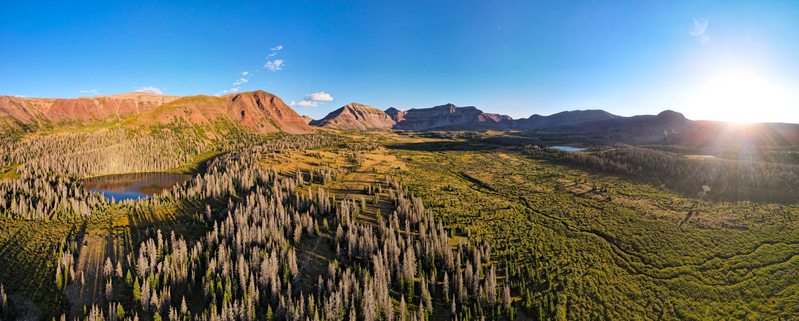
Kings Peak is the highest mountain in Utah at 13,528 feet (4,123 meters), located in the Uinta Mountains within the High Uintas Wilderness Area of northeastern Utah. Generally, the peak is named for Clarence King (1842-1901), the first director of the U.S. Geological Survey and a prominent 19th-century American geologist who led the U.S. Geological Exploration of the Fortieth Parallel. Specifically, Kings Peak is one of the more remote state highpoints in the continental United States, accessed via a 14.4-mile one-way approach through Henrys Fork Basin from the nearest trailhead. Notably, the Uinta Mountains containing Kings Peak are unique among major American ranges — they are the only large east-west running range in the continental United States, contrasting with the typical north-south orientation of most American ranges (Rockies, Cascades, Sierra Nevada, Appalachians).
Key Takeaways
- Utah’s highest peak: 13,528 ft (4,123 m) — the Utah state highpoint.
- Standard route is 28.8 miles round trip via Henrys Fork Trailhead.
- 2-3 day backpacking trip — not a day hike for most.
- Class 2 scramble on the summit ridge — no technical climbing.
- Best season July-September — snow-bound rest of year.
- Free wilderness permit required for overnight stays.
- ~4 hours from Salt Lake City — among the more remote state highpoints.
- Bear-resistant food storage required by wilderness regulations.
- Afternoon thunderstorms common — target pre-noon summit.
- The Uintas are the only major east-west range in the continental US.
📊 Kings Peak Quick Facts
- Elevation
- 13,528 ft (4,123 m)
- Prominence
- 6,348 ft
- Range
- Uinta Mountains
- State
- Utah (Duchesne County)
- Wilderness
- High Uintas Wilderness
- National Forest
- Ashley NF
- Coordinates
- 40.78°N, 110.37°W
- Named For
- Clarence King (USGS)
- State Highpoint
- Yes (Utah)
- Standard Route
- Henrys Fork TH
- Distance RT
- 28.8 miles
- Elevation Gain
- ~4,300 ft
- Difficulty
- Class 2 (scramble)
- Typical Duration
- 2-3 days
- Trailhead Elevation
- 9,400 ft
- Best Season
- July-September
- Permit Cost
- Free
- Group Size Limit
- 14 people
- Drive from SLC
- ~4 hours, 215 mi
- Wilderness Year
- Designated 1984
✓ Editorial Trust Signals
- Utah-based: Local mountain expertise
- Independent: No affiliate sponsorship
- Cross-referenced: USFS, USGS, NPS
- Last verified: June 9, 2026
- Review cycle: Quarterly
- Safety review: Dawson Ludlow (WFA)
- Gear review: Walker Ludlow
- 700+ source pages: Cross-linked
What Is Kings Peak?
Kings Peak is the highest mountain in Utah at 13,528 feet (4,123 meters), located in the Uinta Mountains within the High Uintas Wilderness Area of northeastern Utah. Generally, the peak is named for Clarence King (1842-1901), the first director of the U.S. Geological Survey and a prominent 19th-century American geologist who led the U.S. Geological Exploration of the Fortieth Parallel. Specifically, the peak is a Class 2 scramble objective accessed via a multi-day backpacking trip — not the kind of summit that can be car-camped or day-hiked from a roadside trailhead.
What makes Kings Peak particularly notable among American state highpoints is its remoteness. Generally, despite Utah’s substantial population concentrated in the Wasatch Front, Kings Peak sits in one of the more remote corners of the state — approximately 4 hours and 215 miles from Salt Lake City, accessed via Wyoming roads before re-entering Utah. Specifically, the Henrys Fork Trailhead is itself remote, located on gravel forest roads with limited services in the surrounding area. Notably, this remoteness contributes to the Kings Peak experience — climbers travel through some of the least-developed alpine terrain in the lower 48 states.
Where Is Kings Peak? Location and Geography
Kings Peak is located in northeastern Utah, Duchesne County, within the High Uintas Wilderness Area of Ashley National Forest. Generally, the peak sits roughly 100 miles east of Salt Lake City as the crow flies, but road access requires driving north through Wyoming before turning south back into Utah — making the practical driving distance approximately 215 miles via I-80 and US-191.
| Geographic Detail | Information |
|---|---|
| State | Utah |
| County | Duchesne County |
| Mountain Range | Uinta Mountains |
| National Forest | Ashley National Forest (USFS) |
| Wilderness Area | High Uintas Wilderness (designated 1984) |
| Coordinates | 40.7762°N, 110.3725°W |
| Summit Elevation | 13,528 ft (4,123 m) |
| Topographic Prominence | 6,348 ft (1,935 m) |
| Nearest Town (services) | Mountain View, Wyoming or Vernal, Utah |
| Distance from Salt Lake City | ~215 miles, ~4 hours drive |
When to Hike Kings Peak
The viable season for Kings Peak is July through September, with mid-July through mid-August being the optimal window. Generally, the standard route becomes snow-free by mid-July in average snow years (later in heavy snow years), remains generally accessible through August, and starts deteriorating with early storms by mid-September. Specifically, outside this window, snow conditions make the high-elevation portions of the route unsafe for standard backpacking and create avalanche risk in certain sections.
| Month | Conditions | Recommendation |
|---|---|---|
| October-May | Heavy snow, avalanche risk, frozen lakes, severe cold | Not recommended for non-mountaineers |
| June | Snow remaining at higher elevations, swollen creeks, muddy trails | Possible for experienced backpackers with snow gear |
| Early July | Late snow melt, mosquitoes peak, water sources strong | Possible but pack snow gear and mosquito protection |
| Late July – Early August | Optimal conditions, wildflower peak, stable weather | Best window — popular, book lodging early |
| August | Warm days, cool nights, generally stable; afternoon thunderstorms common | Excellent conditions, target pre-noon summit |
| September | Cooler temperatures, color change, early storms possible | Good conditions but watch forecasts carefully |
| October | First snows arrive, freezing nights, short days | Possible early month with proper gear; risky |
Mid-August is the sweet spot for Kings Peak. Generally, conditions are optimal: snow is fully melted, wildflowers are still abundant, mosquitoes have declined from July peak, weather remains relatively stable, and water sources are reliable. Specifically, August 10-25 typically offers the best balance of conditions and lighter crowds than the late July peak. Notably, weekend trips during this window benefit from arriving Thursday or Friday to secure the best campsites at Dollar Lake before weekend traffic.
Getting to the Henrys Fork Trailhead
The standard Kings Peak trailhead is Henrys Fork Trailhead at 9,400 feet elevation. Generally, access requires approximately 4 hours of driving from Salt Lake City via a route that goes through Wyoming. Specifically, the standard driving route:
- From Salt Lake City: Drive east on Interstate 80
- Through Wyoming: Continue east on I-80 to Fort Bridger, Wyoming (approximately 130 miles)
- South on US-191: Take US-191 south from Fort Bridger
- Final approach: Turn west on County Road 077, then onto National Forest Road 077 to reach Henrys Fork Trailhead
- Distance and time: Approximately 215 miles, 4 hours driving time depending on traffic
Vehicle considerations: The final approach to Henrys Fork Trailhead is on gravel forest road. Generally, standard cars can make the drive in dry conditions but a high-clearance vehicle is recommended after rain or in spring/late season when the road may be muddy. Specifically, the parking area at the trailhead is moderately sized and can fill during peak weekends — arrive early Friday afternoon for weekend trips.
Many Kings Peak hikers stay overnight in Mountain View, Wyoming before the hike. Generally, Mountain View is the closest substantial town to Henrys Fork Trailhead (approximately 1 hour drive). Specifically, the town offers basic services including motels, restaurants, gas stations, and a grocery store for last-minute supplies. Notably, this approach reduces day-of-hike driving fatigue and allows an earlier trail start.
Permits and Wilderness Regulations
The High Uintas Wilderness requires a free wilderness use permit for all overnight visitors. Generally, the permit is available via self-registration at the Henrys Fork Trailhead kiosk and at other High Uintas access trailheads. Specifically, the permit takes 2-5 minutes to complete and includes basic information about your group, planned route, and expected duration.
| Regulation | Detail |
|---|---|
| Permit cost | Free |
| Permit location | Self-register at trailhead kiosk |
| Day hikes | No permit required (but subject to wilderness regulations) |
| Group size limit | 14 people maximum |
| Stock limit | 15 head of livestock |
| Camping setbacks | 200 feet from water sources and trails |
| Campfires | Allowed but stoves recommended; check current fire restrictions |
| Food storage | Bear-resistant container required (black bears present in lower elevations) |
| Pets | Dogs allowed on leash (recommended for wildlife and livestock encounters) |
| Bicycles + motorized | Prohibited in wilderness (federal regulation) |
The Standard Route: Henrys Fork Trailhead via Henrys Fork Basin
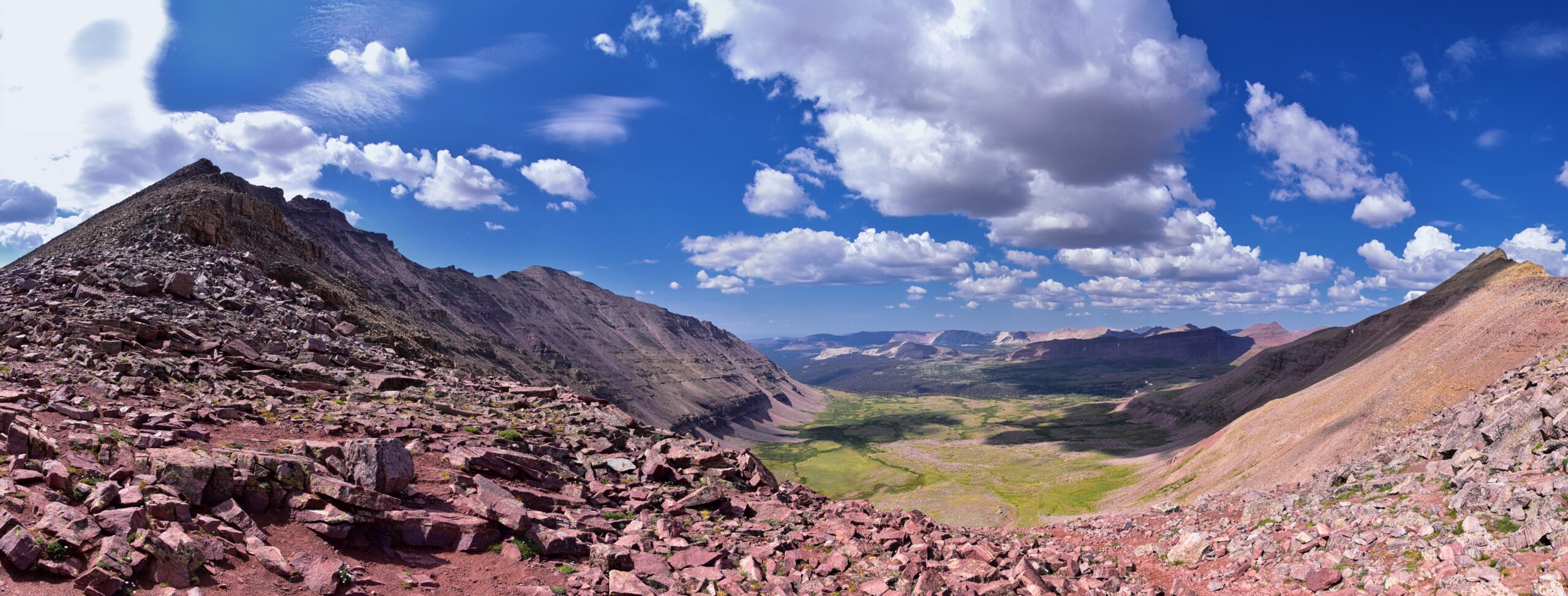
The standard Kings Peak route ascends from Henrys Fork Trailhead through Henrys Fork Basin, over Gunsight Pass, and to the summit ridge via a Class 2 scramble. Generally, this is the route used by 90%+ of Kings Peak ascents and is the most direct path. Specifically, the route covers 28.8 miles round trip with approximately 4,300 feet of total elevation gain.
| Trail Segment | Distance | Elevation | Notes |
|---|---|---|---|
| Trailhead | 0 miles | 9,400 ft | Self-register for permit, last vehicle access |
| Henrys Fork Basin entry | ~6 miles | ~10,400 ft | Forest opens to alpine basin |
| Dollar Lake | ~7 miles | 10,800 ft | Standard Day 1 camp |
| Henrys Fork Lake | ~8 miles | 10,900 ft | Alternative camp area |
| Upper Henrys Fork Basin | ~10 miles | 11,200 ft | Highest practical camp |
| Gunsight Pass | ~12 miles | 11,888 ft | Crossover into Painter Basin |
| Summit ridge base | ~13.5 miles | 12,700 ft | Class 2 scramble begins |
| Kings Peak summit | 14.4 miles one-way | 13,528 ft | Summit |
Day-by-Day Itinerary
The recommended itinerary for most hikers is the 3-day plan with two nights of camping. Generally, this allows for weather contingency and reduces the risk of summit-day failure if you arrive at the trailhead late. Specifically, here are the three standard itinerary options:
Day 1: Trailhead to Dollar Lake
Establish basecamp in Henrys Fork Basin with afternoon time to settle in.
Day 1 covers the approach hike from the Henrys Fork Trailhead through the lower forest section into Henrys Fork Basin. Generally, the trail follows Henrys Fork Creek for the first several miles through lodgepole pine and spruce forest before the terrain opens into the alpine basin. Specifically, the trail is well-maintained and easy to follow with no significant route-finding required.
- Start time: Plan to start by 10 AM or earlier to reach camp with afternoon time for setup
- Trail conditions: Well-maintained forest trail then open alpine basin
- Water sources: Henrys Fork Creek runs alongside the trail; multiple crossings provide reliable water
- Camp setup: Dollar Lake offers the most established campsites with good water access and scenic value
- Afternoon activities: Explore basin, fish, rest, hydrate, organize summit-day gear
Day 2: Summit Kings Peak (Round Trip from Camp)
The summit day — early start, Gunsight Pass, Class 2 scramble to 13,528 feet.
Day 2 is the summit day, ascending from camp to the summit and returning to the same camp. Generally, this is the most demanding day of the trip with approximately 6-7 miles of hiking and 2,700+ feet of elevation gain. Specifically, the route progresses through upper Henrys Fork Basin, over Gunsight Pass (11,888 ft), into Painter Basin, then onto the summit ridge.
- Start time: Pre-dawn start (4-5 AM) recommended to ensure pre-noon summit
- Gunsight Pass: 11,888 ft saddle crossing — the literal “gunsight” notch separating Henrys Fork from Painter Basin
- Painter Basin traverse: Cross the upper basin to reach the southwest ridge of Kings Peak
- Summit ridge: Class 2 scramble approximately 800 vertical feet over rocky terrain
- Summit time target: Reach summit by 11 AM, descend by 1 PM to avoid afternoon storms
- Return to camp: Reverse route to Dollar Lake camp; afternoon recovery
Summer afternoons in the Uinta Mountains commonly produce thunderstorms with significant lightning risk on the exposed summit ridge. Generally, target a pre-11 AM summit and begin descent immediately. Specifically, if any thunderstorm signs appear (building cumulus, darkening, rumbling), turn back immediately — the summit will be there next year. Notably, multiple Kings Peak hikers have been struck by lightning on the summit ridge over the decades.
Day 3: Return to Trailhead
Pack out, hike back to the trailhead, celebrate at a Wyoming or Utah burger spot.
Day 3 is the return hike from camp back to the Henrys Fork Trailhead. Generally, this is the easiest day of the trip with downhill or flat terrain dominating. Specifically, plan to break camp by 9 AM to ensure arrival at the trailhead with daylight remaining and time for the 4-hour drive home.
- Break camp: 8-9 AM start; ensure all gear packed and trash collected
- Trail conditions: Same route in reverse; well-maintained throughout
- Pace: Slightly faster than approach day due to downhill terrain
- Trailhead arrival: 1-3 PM typical, leaving time for drive to Mountain View or Salt Lake City
- Celebration meal: Mountain View, Wyoming, or Park City, Utah offer post-hike dining options
Alternative Routes
While the Henrys Fork standard route handles ~90% of Kings Peak ascents, several alternatives exist. Generally, alternatives are longer and less-traveled but offer different perspectives on the Uinta Mountains. Specifically, the main alternatives:
Yellowstone Drainage Approach (South Side)
From Swift Creek Campground on the south side of the Uintas, hikers can approach Kings Peak from the Yellowstone Drainage. Generally, this route is 32-36 miles round trip and offers a less-crowded experience but adds an additional pass. Specifically, this approach is better suited to experienced backpackers comfortable with longer trips and more route-finding.
West Fork Blacks Fork Approach
The West Fork Blacks Fork Trailhead provides another southern approach. Generally, this route is less commonly used and offers solitude but covers more distance. Specifically, this approach is recommended only for experienced wilderness backpackers seeking less-traveled terrain.
Single-Day Push (Not Recommended for Most)
Some experienced ultra-fit hikers attempt Kings Peak as a single-day round trip via the standard route. Generally, this requires approximately 12-16 hours of continuous hiking, 28.8 miles, and 4,300 feet of elevation gain in one push. Specifically, this approach is not recommended for most hikers due to weather exposure, fatigue-induced injury risk, and inability to handle weather contingency. Notably, even very fit hikers should attempt the single-day push only with extensive backpacking experience and bombproof weather forecast.
All Utah 13ers → 50 State Highpoints →Gear Requirements
Kings Peak requires full multi-day backpacking gear with allowance for cold nights, variable weather, and the need to carry everything for 2-3 days. Generally, this is not a day-pack objective — the standard route requires overnight equipment. Specifically, the essential gear list:
Big Three (Pack, Shelter, Sleep System)
- Backpack: 50-65 liter capacity, comfortable load up to 35-40 pounds
- 3-season tent: Free-standing preferred for varied campsite terrain
- Sleeping bag: Rated to 20°F (nights can drop to 30-40°F even in summer)
- Sleeping pad: R-value 3+ for ground insulation
Food and Water
- Bear-resistant food container: Required by wilderness regulations
- Water filter or purification: Sawyer Squeeze, Katadyn BeFree, or chemical (Aquatabs)
- Cooking system: Lightweight canister stove, fuel, pot, utensils
- Food: 2-2.5 lb per day per person (high calorie density)
- Snacks: Trail mix, bars, dried fruit accessible during hiking
Clothing (Layered System)
- Base layers: Merino wool or synthetic (avoid cotton)
- Insulation layer: Fleece or light down jacket
- Shell layer: Waterproof and breathable rain jacket and pants
- Hiking pants: Convertible or full-length, durable
- Warm hat and gloves: Even in summer
- Sun hat: Wide-brimmed for high-altitude UV exposure
- Hiking boots: Sturdy, broken-in, ankle support for rough terrain
- Camp shoes: Lightweight for around camp
Navigation and Safety
- Topographic map: USGS Kings Peak quadrangle or Trails Illustrated #704
- Compass: Even with GPS as backup
- Headlamp + spare batteries: Critical for early morning summit starts
- First aid kit: Basic kit with blister care, medications
- Emergency communication: Satellite messenger (Garmin inReach, ZOLEO) recommended in remote area
- Trekking poles: Highly recommended for stream crossings and downhill
- Sunscreen SPF 50+: UV exposure at altitude is severe
- Sunglasses: With UV protection
Difficulty and Fitness Required
Kings Peak is a moderate to strenuous backpacking objective rated as Class 2 with no technical climbing. Generally, the challenge is endurance rather than difficulty — 28.8 miles round trip with significant elevation gain over 2-3 days carrying overnight gear. Specifically, the fitness requirements:
- Backpacking experience: Comfortable with multi-day pack-supported trips
- Cardio fitness: Able to hike 8+ miles per day at altitude with a 25-35 lb pack
- Leg strength: Built up through training hikes with weight
- Altitude tolerance: Comfortable sleeping above 10,000 ft and climbing to 13,500 ft
- Class 2 scrambling: Comfortable on rocky terrain requiring occasional hands
Good preparation hikes for Kings Peak (in Utah) include: Mount Timpanogos (11,752 ft, day hike with significant elevation gain), Lone Peak (Wasatch front, technical wilderness day hike), Mount Nebo (11,933 ft, alternative high point in central Utah), and any overnight backpacking trip with 4,000+ feet of elevation gain. Specifically, complete at least 2-3 overnight trips with full pack weight before attempting Kings Peak. Notably, the cardiovascular demands at altitude are best prepared through prior altitude exposure.
Safety Considerations
(1) Lightning on exposed summit ridge — afternoon thunderstorms common; target pre-noon summit. (2) Altitude sickness — symptoms above 10,000 ft for unacclimatized hikers; sleep low if possible before summit day. (3) Hypothermia from sudden weather changes — temperatures can drop rapidly even in summer; always carry layers. (4) Stream crossings — Henrys Fork Creek can be high during early summer or after storms; use trekking poles. (5) Navigation in poor weather — basin and ridge are confusing in fog; carry map and compass. (6) Remote location — emergency services are hours away; carry satellite communication device. (7) Wildlife encounters — moose are common and can be aggressive when surprised; give them wide berth.
Camping and Water Sources
The standard camping areas are Dollar Lake and Henrys Fork Basin, both within 7-10 miles of the trailhead. Generally, established sites are present at both locations with minor variation in access and exposure.
| Campsite | Distance from TH | Elevation | Water | Notes |
|---|---|---|---|---|
| Lower Henrys Fork | 4-5 miles | ~10,200 ft | Henrys Fork Creek | Forested camping, lower altitude, longer summit day |
| Dollar Lake | 7 miles | 10,800 ft | Lake water | Most popular; multiple established sites |
| Henrys Fork Lake | 8 miles | 10,900 ft | Lake water | Slightly less crowded than Dollar Lake |
| Upper Basin | 9-10 miles | 11,000-11,200 ft | Creeks/snow | Highest camp, exposed, shortens summit day |
Camp regulations: All camping must be at least 200 feet from water sources, lakes, and trails. Generally, use established sites where available rather than creating new sites — alpine vegetation is fragile. Specifically, the High Uintas Wilderness has significant impact concerns due to popularity; respect for Leave No Trace principles is essential.
Wildlife and Ecology
The High Uintas Wilderness supports diverse alpine and subalpine wildlife. Generally, sightings vary by elevation and time of day. Specifically, common encounters include:
- Moose: Common in Henrys Fork Basin — give wide berth, especially cow-calf pairs
- Elk: Present at lower elevations, less common above treeline
- Mountain goats: Occasional sightings on summit ridges
- Bighorn sheep: Rare in the Uintas but present
- Black bears: Present at lower elevations; bear-resistant food storage required
- Marmots: Abundant in talus fields — watch packs and food
- Pikas: Common in alpine talus, indicator species for climate research
- Ground squirrels: Will raid food at camp if accessible
- Golden eagles: Soaring above ridges
- White-tailed ptarmigan: Alpine bird, well-camouflaged
Utah’s bear population is exclusively black bears — there are no grizzly bears in Utah. Generally, this reduces the safety concern relative to grizzly bear country (Wyoming, Montana, Idaho) but black bear food protection is still required. Specifically, bear-resistant food containers are mandated by wilderness regulations and protect both the bears and hikers. Notably, properly storing food also protects from rodents and other smaller wildlife.
Cost Breakdown
Kings Peak is a relatively budget-friendly summit objective compared to most major American mountains. Generally, costs are minimal beyond gear, food, and travel — there are no guide fees, permit costs, or commercial expenses required. Specifically, typical costs:
| Cost Item | Range (USD) | Notes |
|---|---|---|
| Wilderness permit | $0 | Free self-registration |
| Vehicle travel from SLC | $60-100 | Round-trip fuel, ~430 miles total |
| Mountain View, WY lodging | $80-150 | Optional pre-hike night |
| Food (3 days) | $30-60 | $10-20/day backpacking food |
| Total per person, owned gear | $100-300 | If you already have backpacking gear |
| Initial gear investment (if needed) | $800-2,500 | Tent, pack, bag, pad, stove, layers, boots |
Common Mistakes Kings Peak Hikers Make
(1) Summit day too late — climbers who reach summit after 12 PM expose themselves to afternoon thunderstorms. (2) Underestimating distance — 28.8 miles round trip is substantial; many beginners underestimate the effort. (3) Wrong shoes — running shoes or worn boots fail on rocky summit ridge terrain. (4) Inadequate water treatment — water is abundant but must be filtered/purified; giardia and other pathogens are present. (5) No bear-resistant storage — required by regulation and protects food from all wildlife. (6) Cotton clothing — fails when wet; pack only synthetic and wool layers. (7) Skipping pre-trip acclimatization — lowland hikers struggle without prior altitude exposure. (8) Single-day attempt unprepared — the 12-16 hour single-day push is for experienced ultrarunners only.
Related Utah Peaks
Kings Peak is the highest Utah peak, but Utah has many other significant mountains worth combining or considering. Generally, Utah is divided into several mountain regions:
| Mountain | Elevation | Region | Difficulty |
|---|---|---|---|
| Kings Peak | 13,528 ft | Uinta Mountains | Class 2 backpack (this guide) |
| Mount Peale | 12,727 ft | La Sal Mountains | Class 2 day hike |
| Mount Mellenthin | 12,645 ft | La Sal Mountains | Class 2 day hike |
| Delano Peak | 12,174 ft | Tushar Mountains | Class 1 hike (highpoint of Tushars) |
| Mount Nebo | 11,933 ft | Wasatch Range | Class 1-2 day hike |
| Mount Timpanogos | 11,752 ft | Wasatch Range | Class 1 day hike |
| Lone Peak | 11,253 ft | Wasatch Range | Class 3 day hike or 2-day |
| Mount Olympus | 9,026 ft | Wasatch Range | Class 1-2 day hike |
Frequently Asked Questions About Kings Peak Utah
What is the elevation of Kings Peak?
Kings Peak rises 13,528 feet (4,123 meters) above sea level, making it the highest mountain in Utah. The peak is located in the Uinta Mountains within the High Uintas Wilderness Area of Ashley National Forest in northeastern Utah. Coordinates are approximately 40.7762°N, 110.3725°W. Kings Peak is the state highpoint of Utah and ranks among the more challenging state highpoints due to its remote location and required multi-day backpacking access.
How long does it take to hike Kings Peak?
The standard Henrys Fork Trailhead route to Kings Peak is 28.8 miles round trip and typically requires 2-3 days. Most hikers complete the trip as a 2-night backpacking trip with summit on the middle day: Day 1 hike 7-8 miles to Dollar Lake or Henrys Fork Basin (~4-6 hours); Day 2 summit day with 6-7 mile round trip from camp (~4-6 hours); Day 3 return 7-8 miles to trailhead (~4-6 hours). Fit hikers can compress to a 2-day trip; some attempt the entire route as a single day push (12-16 hours) though this is not recommended due to weather risk and elevation gain.
Do you need a permit to hike Kings Peak?
Yes, a free wilderness use permit is required for all overnight visitors to the High Uintas Wilderness Area which contains Kings Peak. The permit is available via self-registration at the Henrys Fork Trailhead kiosk and at other access trailheads. There is no cost. Group size is limited to 14 people per Forest Service wilderness regulations. Day hikers are not required to obtain permits but are subject to the same wilderness regulations regarding pack-out trash, Leave No Trace practices, and group size limits.
When is the best time to hike Kings Peak?
July through September is the best season for Kings Peak. The standard route becomes generally snow-free by mid-July, weather remains relatively stable through August, and conditions begin deteriorating in September with potential early storms. October through June, the trail is typically snow-covered with significant avalanche risk and is not recommended for standard backpacking. Late July through mid-August offers the most stable weather. Wildflowers peak in late July and early August. Afternoon thunderstorms are common throughout summer; target pre-noon summit attempts.
How hard is Kings Peak to hike?
Kings Peak is a moderate to strenuous backpacking objective rated as a Class 2 hike with no technical climbing required. The challenge is endurance rather than technical difficulty: 28.8 miles round trip with approximately 4,300 feet of elevation gain over 2-3 days carrying overnight gear. The final summit ridge involves Class 2 scrambling on rocky terrain. The high altitude (camping above 10,000 feet, summit at 13,528 feet) requires acclimatization. Most hikers with basic backpacking experience and good fitness can complete the route; novice backpackers should attempt easier overnight trips first.
How far is Kings Peak from Salt Lake City?
Kings Peak is approximately 4 hours and 215 miles from Salt Lake City by road. The route goes east on I-80 through Wyoming, then south on US-191 back into Utah to the Henrys Fork Trailhead. The trailhead is in a remote area approximately 1-2 hours from the nearest substantial services in Mountain View, Wyoming, or Vernal, Utah. Despite Utah’s substantial population in the Wasatch Front, Kings Peak is one of the more remote state highpoints in the U.S. — accessible only via secondary roads and a long trailhead drive.
Where do you camp on Kings Peak?
The standard camping areas for Kings Peak are at Dollar Lake (10,800 ft) and in Henrys Fork Basin (10,900-11,200 ft). Dollar Lake is the most popular destination with established campsites, water access, and excellent scenery, located approximately 7 miles from the trailhead. Higher camps in Henrys Fork Basin reduce the summit day distance and elevation gain but offer less wind protection and reduced firewood. Wilderness regulations prohibit camping within 200 feet of water sources or trails. Use established sites where available to minimize impact on alpine vegetation.
Are there other routes to Kings Peak?
Yes, alternative routes exist though the Henrys Fork Trailhead is the standard and most popular approach. The Yellowstone Drainage approach from the south (via Swift Creek Campground) is approximately 32-36 miles round trip and adds an additional pass. The West Fork Blacks Fork approach offers a less-traveled alternative for experienced backpackers. All routes require multi-day backpacking and the Henrys Fork approach remains the most direct with the best trail conditions. Single-day technical alternatives via the Painter Basin route exist for experienced mountaineers but require approximately 30+ miles and 5,000+ feet of gain in one day.
What wildlife will I see on Kings Peak?
The High Uintas Wilderness supports diverse alpine wildlife. Common sightings include moose (often in Henrys Fork Basin), elk (less common at high elevation), mountain goats (occasionally on the summit ridges), bighorn sheep (rare), marmots (abundant in talus fields), pikas (talus dwellers), and various small mammals. Bird species include golden eagles, white-tailed ptarmigan, mountain bluebirds, and Clark’s nutcrackers. Black bears are present in the lower elevations though uncommon — bear-resistant food storage is required by regulation. Utah has no grizzly bears.
What gear do you need for Kings Peak?
Essential gear for Kings Peak includes: backpacking pack (50-65L), 3-season tent, sleeping bag rated to 20°F (nights can be cold even in summer), sleeping pad with R-value 3+, bear-resistant food canister, water filter or purification, trail map and compass, headlamp with spare batteries, layered clothing (moisture-wicking base, insulating mid-layer, waterproof shell), sturdy broken-in hiking boots, trekking poles, sun protection (the high-altitude UV exposure is intense), and adequate food (extra day’s worth recommended for weather contingency). Summer weather can shift rapidly — always pack for potential rain, wind, and below-freezing overnight temperatures.
Methodology & Editorial Standards
How This Guide Was Built
1. Primary Source: Utah-Based Field Experience
This guide draws on Global Summit Guide’s Utah-based mountaineering experience including direct familiarity with the Uinta Mountains, the Wasatch Range, the Wasatch Front, and Utah’s high country generally. Specifically, the editorial team lives and operates in Utah, providing direct access to local knowledge, regional weather patterns, and the practical realities of Utah backpacking.
2. Official U.S. Forest Service Sources
Trail information, permit requirements, wilderness regulations, and access details are cross-referenced with the Ashley National Forest official information for the High Uintas Wilderness and Uinta-Wasatch-Cache National Forest regional management.
3. USGS Topographic and Elevation Data
Elevation figures, coordinates, and trail mileages are verified against U.S. Geological Survey data including the official Kings Peak elevation of 13,528 feet and the USGS Kings Peak 7.5-minute quadrangle topographic map.
4. Internal Cross-Reference
This page is cross-referenced against Global Summit Guide’s existing Utah coverage including the Best Mountains in Utah, Utah 13ers, Wasatch Range Peaks, Utah Range Highpoints, and 50 State Highpoints pages.
5. Editorial Independence
No affiliate partnerships influence recommendations. The article generates revenue only through Google AdSense display ads when applicable. Specific gear, lodging, and service recommendations are based on direct experience or independent research.
6. Update Cycle
This guide is reviewed quarterly. Next scheduled review: September 2026. Trail conditions, regulations, access, and pricing change; the user is encouraged to verify current information with the U.S. Forest Service before trip departure.
Sources and References
Numbered Source References
This Kings Peak guide synthesizes data from authoritative U.S. Forest Service, USGS, and Utah-based sources combined with Utah field experience.
- U.S. Forest Service Ashley National Forest · https://www.fs.usda.gov/ashley — High Uintas Wilderness management and access information.
- U.S. Forest Service Uinta-Wasatch-Cache National Forest · https://www.fs.usda.gov/uwc — Regional management.
- U.S. Geological Survey (USGS) · https://www.usgs.gov/ — Elevation, coordinates, topographic data for Kings Peak.
- Wilderness.net · High Uintas Wilderness profile — Federal wilderness management resource.
- Utah Department of Natural Resources · State-level natural resource management.
- National Park Service Wilderness · https://www.nps.gov/ — Wilderness ethics and Leave No Trace standards.
- Highpointers Club · State highpoints organization and trip reports.
- Mountaineering: The Freedom of the Hills (10th edition) — Genre-standard backpacking and mountaineering reference.
- Trails Illustrated #704 — High Uintas Wilderness topographic map.
- Global Summit Guide internal research — Cross-referenced from Utah coverage and Utah-based field experience.
Methodology note. Quarterly review cycle — next review September 2026. Trail conditions, regulations, road access, and fees change; verify all information with the U.S. Forest Service Ashley National Forest before trip departure.
About the Author
Explore More Utah Mountains
Plan Your Kings Peak Trip
Kings Peak is one of Utah’s signature backpacking objectives — a 13,528-foot summit accessed via 28.8 miles of high-alpine wilderness, completed over 2-3 days with proper preparation. Generally, the best season runs July through September with mid-August as the sweet spot. Specifically, the standard Henrys Fork Trailhead route handles 90%+ of ascents and requires no technical climbing — just solid backpacking fitness and respect for the High Uintas weather patterns.
Best Mountains in Utah → All Utah 13ers →