
Last updated May 23, 2026
Tre Cime di Lavaredo: The Giro Loop Hike, Comici North Face & Drei Zinnen 2026 Guide
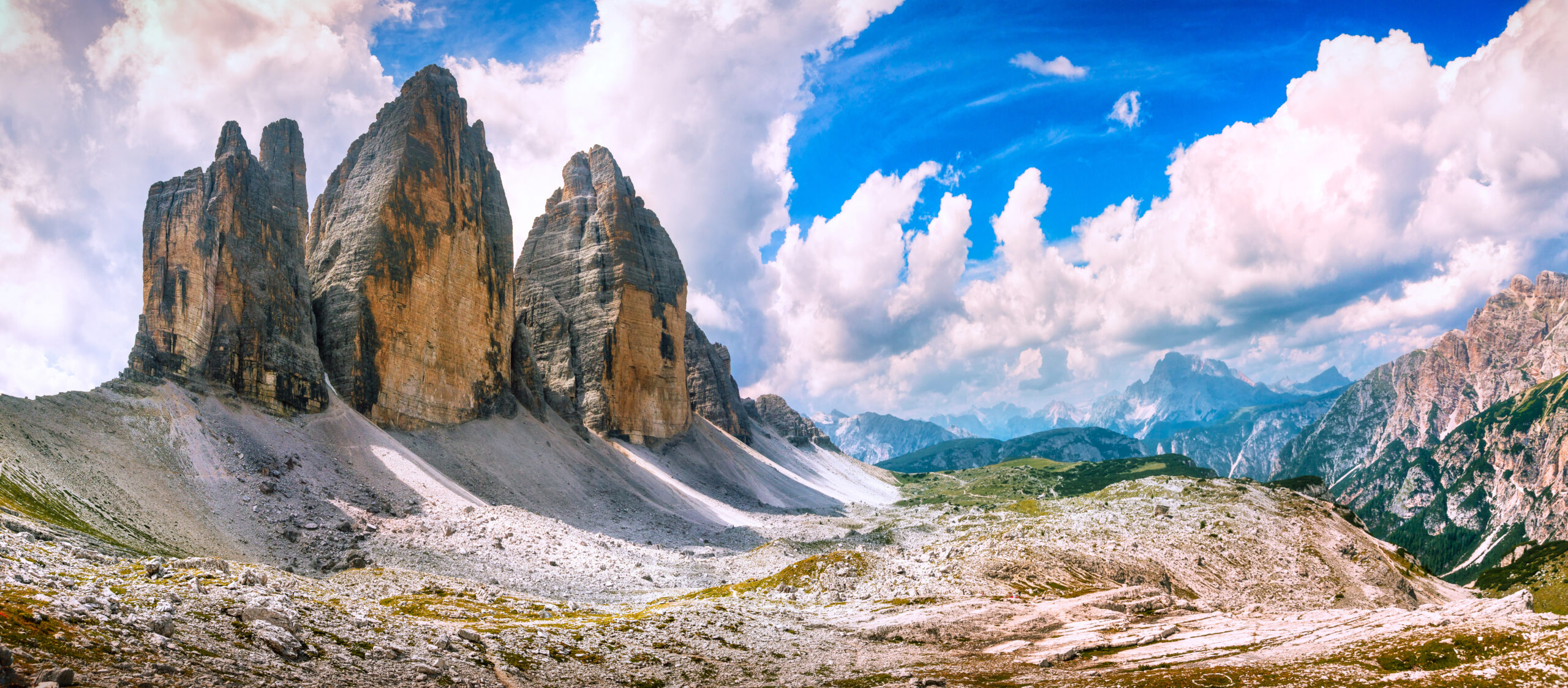
Cima Grande 2,999 m · Cima Ovest 2,973 m · Cima Piccola 2,857 m — the most recognised mountain group in the Alps, where the Innerkofler family opened all three peaks (1869-1881), where Emilio Comici climbed his “drop of water” north face in 1933, and where a WWI front line ran through summits across what is now Cortina’s 2026 Winter Olympic territory. The 10.8 km Giro delle Tre Cime is the most famous day hike in the Dolomites. UNESCO World Heritage. Online toll road reservation mandatory in 2026.
The Tre Cime di Lavaredo (German: Drei Zinnen — Three Merlons) are three free-standing limestone towers in the Sexten/Sesto Dolomites of northeastern Italy, rising from an alpine plateau at approximately 2,200m and piercing the sky with vertical faces on all sides. They are, by any reasonable measure, the most recognised mountain group in the entire Alps — a silhouette so distinctive and so repeatedly photographed that it has become global shorthand for the very idea of mountains. Reinhold Messner called them “a mirror of the evolution of alpinism” — from the first hesitant ascents of 1869 to free solos of the modern era, every generation of climbers has returned here to define what is possible.
The three peaks span a cultural and political border: the north faces look into German-speaking South Tyrol (formerly Austria-Hungary until 1919); the south faces look into Italian-speaking Belluno (Veneto). The names themselves encode this duality — Tre Cime in Italian, Drei Zinnen in German, both correct, both in use. The summit ridge is still, as it has been for centuries, a language border. The three peaks — Cima Grande (2,999m), Cima Ovest (2,973m), and Cima Piccola (2,857m) — were first climbed across a span of 12 years, all by the same guide family: the Innerkoflers of Sexten. The north face of Cima Grande was climbed by Emilio Comici in 1933, becoming one of the Six Great North Faces of the Alps. Between the first ascent and Comici’s route lay the catastrophe of the First World War, which turned these peaks into a front line and killed one of the very Innerkoflers who had opened them to climbing.
⚠ 2026 Access Update — Toll Road Reservation Now €40
The mandatory online reservation system continues in 2026 with one significant change: the toll fee has increased to €40 per vehicle (up from €30 in 2025). The increase funds road maintenance and environmental protection.
Find Hotels, Flights & Trips for the World’s Best Hiking Destinations
The Global Summit Guide Travel Shop on Expedia — curated for outdoor adventurers, mountaineers, and serious hikers. Patagonia to the Alps. Nepal to the Rockies. Curated lodging for every region we cover.
Explore Travel Shop on Expedia →How to book: Reservations for the 2026 season open end of April 2026 at auronzo.info or pass.auronzo.info. Provide email, phone number, and license plate (rental car drivers can add the plate up until 11:59 PM the day before arrival). Choose a 12-hour time slot from the real-time calendar.
Cortina 2026 Olympics context: Cortina d’Ampezzo (35 km from Tre Cime) co-hosts the 2026 Winter Olympics with Milan February 6-22, 2026. The post-Olympic spring/summer 2026 visitor season is expected to see substantially elevated demand — book your toll road slot as early as possible.
🥾 I’m a Hiker
The Giro delle Tre Cime loop, viewpoints, day-walks, photographic moments.
Hiker Guide →⛰ I’m a Climber
Cima Grande Normal Route, Comici North Face, Spigolo Giallo, classic Dolomite climbing.
Climber Guide →📜 I’m a Historian
Innerkofler family, Comici’s philosophy, WWI White War, Sepp Innerkofler’s story.
History Section →Tre Cime di Lavaredo Location & Live Weather
The Tre Cime di Lavaredo are in the Sexten/Sesto Dolomites at coordinates 46.6172°N, 12.3033°E. The main access point is Misurina (1,750m) via the toll road to Rifugio Auronzo (2,333m). Distances: Venice 130 km / 2-2.5 hours; Cortina d’Ampezzo 35 km / 45 minutes; Dobbiaco/Toblach 30 km via Bus 444; Milan 380 km / 4.5 hours.
Weather data from Open-Meteo at Cima Grande coordinates 46.6172°N, 12.3033°E. Dolomite afternoon thunderstorms are a characteristic hazard — pattern is typically clear morning → clouds building from noon → storms by 2-3 PM. For any route on the peaks, target summit by noon and descent shortly after.
Tre Cime di Lavaredo At a Glance
Cima Grande
Große Zinne
First ascent August 21, 1869
Grohmann + Franz Innerkofler + Peter Salcher
Normal: UIAA II · South Face · 200m
Cima Ovest
Westliche Zinne
First ascent August 21, 1879
Michel Innerkofler + G. Ploner
Normal: UIAA III · SW Face · 300m
Cima Piccola
Kleine Zinne
First ascent July 25, 1881
Michel + Hans Innerkofler
Normal: UIAA III · SW Face · 300m
| Location | Sexten/Sesto Dolomites — border of South Tyrol (Bolzano) and Belluno (Veneto) |
|---|---|
| Coordinates | 46.6172°N, 12.3033°E (Cima Grande summit) |
| Language border | Summit ridge = boundary between German-speaking South Tyrol and Italian-speaking Belluno |
| UNESCO designation | Within the Dolomites UNESCO World Heritage Site (2009); Three Peaks Nature Park |
| Geology | Dolomia Principale (Hauptdolomit) — Carnian to Rhaetian — ancient tropical coral reef limestone |
| The loop hike | Giro delle Tre Cime — 10.8 km · 400m elevation gain · 3-4 hours · T2-T3 grade |
| Three rifugi | Rifugio Auronzo (2,333m) · Rifugio Lavaredo (2,344m) · Rifugio Locatelli/Dreizinnenhütte (2,405m) |
| 2026 toll fee | €40 per vehicle (increased from €30) including parking |
| 2026 reservation | Mandatory online — opens end of April 2026 at auronzo.info |
| Parking capacity | 700 vehicles at Rifugio Auronzo |
| Toll road open | Late May – late October (weather dependent) |
| Comici North Face | Cima Grande NE face — one of Six Great North Faces of the Alps — first climbed August 13-14, 1933 |
| Comici solo | September 2, 1937 — unroped solo of his own route, first ever |
| WWI history | Front line between Italy and Austria-Hungary 1915-1917 — trenches, tunnels, iron ladders visible |
| Sepp Innerkofler | Killed Monte Paterno July 4, 1915 — guide who became soldier on his own mountain |
| Cortina 2026 Olympics | Co-hosts Winter Olympics with Milan February 6-22, 2026 — Tre Cime 35 km from Cortina |
| Best season | September (quietest, finest light) or late June-early July (before peak crowds) |
| Climbing permits | None required — area within Three Peaks Nature Park, access unrestricted |
| Messner quote | “A mirror of the evolution of alpinism” |
The Giro delle Tre Cime Loop Hike
The Giro delle Tre Cime is the most famous day hike in the Dolomites — 10.8 kilometres around the three towers with views that include both the smooth south faces and the dramatic vertical north walls. The hike is genuinely accessible to most reasonably fit walkers in good weather, but it gets substantially crowded in peak season (July-August). With careful timing — early morning starts or off-peak months — the loop ranks among the most rewarding single-day walks anywhere in the European Alps.
Giro delle Tre Cime — Standard Counter-Clockwise Route
Start point: Rifugio Auronzo (2,333m) at the top of the toll road. Begin by heading north on Trail 101.
Stage 1 — Rifugio Auronzo to Rifugio Lavaredo (30 minutes, 0.5 km): The trail crosses the debris cone of the south faces — the first experience of the Tre Cime at close range, with their smooth south walls rising on your left. The trail is broad, well-marked, and shared with hundreds of other walkers in peak season. Crowds form quickly at this section in July-August — consider starting clockwise (Trail 105) instead for a less congested initial section.
Stage 2 — Rifugio Lavaredo to Forcella Lavaredo (15-20 minutes uphill): From the privately-run Rifugio Lavaredo at the base of the south faces, continue uphill to Forcella Lavaredo (2,454m) — the pass that gives the first direct view north onto the north faces. This moment — cresting the col and suddenly seeing the vertical amphitheatre of three north walls spread before you — is the emotional core of the entire hike. The Comici route is directly above; the Hasse-Brandler Directissima is to its right.
Stage 3 — Forcella Lavaredo to Rifugio Locatelli (45-60 minutes): Continue northwest on Trail 101 to Rifugio Locatelli / Dreizinnenhütte (2,405m) — the most celebrated hut in the Dolomites, positioned directly beneath the north faces. The north face view from this hut is the one that graces every Dolomite postcard and magazine cover. For the finest view away from crowds, walk 5-10 minutes past the hut to the north plateau for an unobstructed 180-degree panorama including Monte Paterno.
Stage 4 — Return via Trail 102 (60-90 minutes back to Rifugio Auronzo): The circuit continues via Trail 102 west across the north side of the massif — traversing beneath the north faces at close range. This is the section where the scale of the Comici and Hasse-Brandler routes is most viscerally apparent: you are walking at the base of what was once thought the most difficult rock face in the world. Return south around the western end of the massif to Rifugio Auronzo.
Crowd management strategy. July and August see 7,000-8,000 visitors per day in peak conditions. Start before 8:00 AM to have Forcella Lavaredo and Rifugio Locatelli viewpoints with manageable crowds. Alternatively, stay overnight at Rifugio Locatelli and walk the north side in early morning light — the golden hour on the north faces is extraordinary, and you’ll have the area essentially to yourself. September is substantially the finest month: significantly fewer visitors, autumn light turns Dolomite limestone gold, stable weather, and cool temperatures.
Hike Without Paying the Toll
Several marked trails allow hikers to approach the Tre Cime on foot from below the toll gate, avoiding the €40 fee entirely:
- Trail 101 from below the toll gate — branches off just before the toll station and leads all the way to Rifugio Auronzo. Adds approximately 1 hour each way to the day. Free parking available at Albergo Chalet area below the toll gate.
- From Lago d’Antorno — shorter walking approach starting near the small lake just before the toll road.
- Bus 31 from Misurina — no booking required, no car reservation needed. DolomitiBus from Misurina-Genzianella stop to Rifugio Auronzo in approximately 20 minutes. Approximately €4 one-way.
- Bus 444 from Dobbiaco/Toblach — requires separate advance booking at tre-cime.bz/ticket. ~50 minutes journey. Approaches from the north side — substantial finest scenic approach.
Climbing the Tre Cime: From Normal Routes to North Faces
The Tre Cime di Lavaredo offer the substantial complete spectrum of Dolomite limestone climbing — from the Innerkofler 1869-1881 Normal Routes (UIAA II-III) climbed daily by guided parties in summer, to the Comici-Dimai north face of 1933 (UIAA VII, one of the Six Great North Faces of the Alps), to the most extreme modern test pieces. Messner’s “mirror of alpinism” formulation is literal: every era of climbing development is preserved here as climbable routes on the same wall.
Cima Grande Normal Route — South Face (UIAA II)
The Normal Route on Cima Grande follows precisely the line taken by Paul Grohmann with Franz Innerkofler and Peter Salcher on August 21, 1869 — the founding moment of serious Dolomite mountaineering. The route is the most popular climbing objective in the entire Dolomites, polished smooth from generations of ascent.
Approach: 80 minutes from Rifugio Auronzo via Rifugio Lavaredo. From the Lavaredo hut continue to the route base at the left-hand side of the South Face.
The route: 200 metres of UIAA II climbing — accessible for most roped parties with basic rock climbing experience. The rock is well-featured but heavily polished; there are sections of fixed rope and some in-situ protection. The grade increases substantially when wet — UIAA II on wet polished limestone becomes a substantially more serious proposition.
Critical safety: The route is susceptible to constant rockfall from parties above. In July-August with multiple roped teams on the face simultaneously, helmets must be worn throughout — not only at the start. Pre-dawn starts (rope up by 6 AM) substantially reduce this hazard.
The summit (2,999m): The view from the highest of the Tre Cime is extraordinary in all directions. Looking down the south face, Rifugio Auronzo is visible far below with its car park. Looking north, the Sexten Dolomites panorama is spread at eye level. A small bivouac box on the summit.
Comici-Dimai Route — Cima Grande North Face
The Comici-Dimai is one of the Six Great North Faces of the Alps — alongside the Eiger, Matterhorn, Grandes Jorasses, Piz Badile, and Petit Dru. It is the only route of the six on Dolomite limestone rather than granite or mixed terrain, giving it a completely different character: warm-coloured, featured, often climbed in rock shoes rather than boots.
Emilio Comici with brothers Giuseppe and Angelo Dimai made the first ascent on August 13-14, 1933, over three days and two nights. The route finds the logical line of weakness on an apparently featureless overhanging wall, ascending cracks, corners, and slabs that hang over the glacier below. Four years later, on September 2, 1937, Comici soloed the route unroped — an act of audacity that has never been fully repeated in the same manner.
The route — bottom to top:
- Lower section (hardest): The first pitches follow the line of weakness through the overhanging base. Maximum grade of UIAA VII. Old pitons of variable trustworthiness — supplement with own gear. Once committed past the initial overhangs, retreat becomes very difficult due to face geometry.
- Middle section: Rises rightward toward the crest before turning back toward the summit line. Less interesting technically but more committing — the overhanging face above means abseiling directly off is not viable. Move efficiently; watch weather constantly.
- Upper section: Brings the route toward the distinctive arête between true north face and NE face. Climbing on the finest rock of the route. Outstanding view: Sexten Dolomites in every direction with Rifugio Locatelli visible far below.
Descent: South Face Normal Route from the Cima Grande summit back to Rifugio Lavaredo, then to Rifugio Auronzo.
Weather warning: Retreat is not an option once established above the lower section. Afternoon thunderstorms — the characteristic Dolomite hazard — are a serious threat on a face of this commitment. Check the forecast meticulously. Alpine start that guarantees summit by noon.
Comici’s “Drop of Water” Philosophy
Emilio Comici (1901-1940) articulated his approach to route-finding in one of the most quoted statements in the history of climbing: “I wish someday to make a route and from the summit let fall a drop of water and this is where my route will go.” The plumb line. The absolute vertical. The most direct path down the face from summit to glacier.
Before Comici, routes on large faces found feasible lines of weakness that might zigzag considerably from side to side, driven by what was possible rather than what was direct. Comici’s philosophy demanded the most direct possible path from top to bottom — finding the way to make vertical logic align with what was actually climbable. His routes on the Cima Grande north face (1933) and the Spigolo Giallo on Cima Piccola embody this aesthetic: they are beautiful precisely because they take the most logical, most direct line through terrain that appears forbidding. Comici died in 1940 at age 39 from a fall during a training descent in the Friulian Dolomites. His career lasted barely 15 years; his routes define the Dolomites to this day.
Other Major Routes on the Tre Cime
Spigolo Giallo (Yellow Edge) — Cima Piccola
The Spigolo Giallo is the dazzling yellow overhanging arête on the south-east face of Cima Piccola — substantial described by climbers as “the characteristic, magnificent, yellow overhanging rock, which falls down to the depth below the obelisk of the southern foresummit almost impossibly slender and slim like an awl.” Climbed by Comici with Mary Varale and Renato Zanutti, the Spigolo Giallo is considered one of the most beautiful routes in all the Dolomites. UIAA VI+. Avoid at high-season weekends: can be dangerously overcrowded.
Hasse-Brandler Directissima — Cima Grande
The next great north face chapter came in 1958 when Lothar Brandler, Dieter Hasse, Jörg Lehne, and Sigi Löw climbed the Directissima — a more direct line than Comici’s, taking the central overhanging yellow wall head-on. 18 pitches, July 6-10, 1958. The route required significant aid and represented a new frontier of commitment on the face. Today UIAA VIII+ with A0 aid. Most belays bolted; not all pegs trustworthy. Very tiring due to length regardless of style.
Via Ferrata De Luca-Innerkofler — Monte Paterno
The Via Ferrata De Luca-Innerkofler on Monte Paterno is one of the finest via ferratas in the Dolomites — combining moderate technical difficulty with deep historical resonance. Named for Sepp Innerkofler (Austrian guide killed here July 4, 1915) and Piero de Luca (Italian Alpini officer who defended the summit in the same engagement). The route begins at Rifugio Locatelli, enters substantial 600m of WWI tunnels dug through Monte Paterno by Italian Alpini (headlamp essential — natural light insufficient), then continues on cabled sections to the summit. The summit gives the finest close-up view of the north faces available without climbing them — the three great towers spread in front at approximately mid-height.
Tre Cime di Lavaredo Through History
The Innerkofler Family — Three Peaks in Twelve Years
The Innerkofler guide family of Sexten/Sesto in South Tyrol made three of the three Tre Cime first ascents. Franz Innerkofler guided Paul Grohmann’s 1869 ascent of Cima Grande. Ten years to the day later, on August 21, 1879, Michel Innerkofler with client G. Ploner made the first ascent of Cima Ovest. Two years later, on July 25, 1881, Michel and Hans Innerkofler made the first ascent of Cima Piccola — the most technically demanding of the three normal routes. The three first ascents span twelve years; all three normal ascent routes still follow the Innerkofler lines. No other guide family in the Dolomites can claim to have opened an entire massif of this stature.
The White War (1915-1917) — Front Line Through the Peaks
Between 1915 and 1917, the Tre Cime di Lavaredo were a front line of the First World War. The pre-1919 border between Italy and Austria-Hungary ran precisely through the peaks — which meant that when Italy entered the war in May 1915, Italian and Austro-Hungarian troops found themselves entrenched on the ridge that the Innerkoflers had climbed for sport less than 40 years earlier.
The conflict in the Dolomites was known as the “White War” (Guerra Bianca) — fought at altitude, in snow and ice, in conditions of extreme cold and isolation, by soldiers who sometimes faced each other from positions just a few hundred metres apart on adjacent peaks. The traces of the White War remain perfectly visible throughout the Tre Cime area: trenches, tunnels carved through the rock, artillery positions, iron ladders, and commemorative plaques scattered along the hiking trails. Monte Paterno (2,744m) — the rocky pyramid northeast of the Tre Cime — is an open-air museum of WWI, with a system of tunnels that the Italian Alpini dug through the mountain to reach their positions without exposure to Austrian fire.
Sepp Innerkofler — July 4, 1915
Sepp Innerkofler was one of the most famous mountain guides in the Sexten/Sesto area — a member of the Innerkofler guide family that had opened the Tre Cime between 1869 and 1881 — and was serving as an Austrian soldier when the war began. On the night of July 4, 1915, Innerkofler led a patrol in a night attack attempting to storm the summit of Monte Paterno, which the Italian Alpini had fortified. Italian sharpshooters spotted the men and opened fire. Sepp Innerkofler was killed on the mountain he knew better than any soldier on either side. It is said that the Italian Alpine soldiers who discovered who had been killed were distraught — many were themselves alpinists who had admired Innerkofler as a guide. His body was laid to rest on the summit of Monte Paterno and later moved to a cemetery in Sexten after the war.
Today, the Via Ferrata De Luca-Innerkofler on Monte Paterno is named jointly after Sepp Innerkofler and Piero de Luca, an Italian Alpini officer who defended the summit in the same engagement — a deliberate act of reconciliation between the nations that once faced each other here.
Full Timeline
Paul Grohmann (Viennese, 1838-1908) with guides Franz Innerkofler and Peter Salcher reached the summit of Cima Grande via the South Face — a route of 200m that remains the Normal Route today. Date considered the founding moment of serious Dolomite mountaineering. Grohmann had already made first ascents of Antelao, Pelmo, Marmolada, Tofana, and others between 1863-1869.
Michel Innerkofler with client G. Ploner made the first ascent of Cima Ovest — exactly ten years to the day after the Cima Grande first ascent. SW Face route, UIAA III, 300m. Still the Normal Route today.
Michel and Hans Innerkofler made the first ascent of Cima Piccola — the most technically demanding of the three normal routes. SW Face, UIAA III, 300m. The Innerkofler family had now opened all three of the Tre Cime in twelve years.
Italy entered World War I in May 1915. The pre-existing Italy-Austria-Hungary border ran through the Tre Cime summits. The Sexten Dolomites became one of the Italian Alpine fronts — substantial 2.5 years of high-altitude warfare in extreme conditions. Tunnels, trenches, iron ladders, and artillery positions throughout the area date from this period.
Austrian mountain guide Sepp Innerkofler — member of the family that had opened the Tre Cime — killed by Italian Alpini sharpshooters during a night attack on Monte Paterno. Buried on the summit, later moved to Sexten cemetery. His death substantial encapsulates the tragedy of the White War: alpinists turned into soldiers facing former companions across the lines.
The Treaty of Saint-Germain-en-Laye transferred South Tyrol from Austria-Hungary to Italy. The political border that had run through the Tre Cime summits substantial disappeared — but the language border did not. German-speaking South Tyroleans continued to use “Drei Zinnen”; Italian speakers continued to use “Tre Cime.” Both names became official.
Emilio Comici with brothers Giuseppe and Angelo Dimai climbed the 550m north face of Cima Grande over three days and two nights — substantial creating one of the Six Great North Faces of the Alps. The route embodies Comici’s “drop of water” philosophy: the absolute vertical from summit to glacier. The route remains the most frequently climbed of the Six Great North Faces.
Four years after the first ascent, Emilio Comici soloed the route unroped — an act of such audacity that it has never been fully repeated in the same manner. The substantial ultimate expression of his philosophy: absolute directness, absolute confidence, no rope to suggest any doubt.
Lothar Brandler, Dieter Hasse, Jörg Lehne, and Sigi Löw climbed the Directissima on Cima Grande — a more direct line than Comici’s, taking the central overhanging yellow wall head-on. 18 pitches. The route required significant aid and represented a new frontier of commitment on the face.
Alex Huber free-soloed the north face of Cima Grande — a feat that would have been incomprehensible to Grohmann in 1869 and nearly incomprehensible to Comici in 1933. From first ascent to free solo: 133 years. The Tre Cime had compressed the entire history of rock climbing into a single wall.
The Dolomites were inscribed as a UNESCO Natural World Heritage Site in 2009, with the Tre Cime as substantial centerpiece of the Sexten Dolomites portion of the designation. The substantial designation substantial recognized substantial outstanding natural beauty and substantial geological significance of the Triassic dolomitic limestone formations.
From summer 2025, online reservation became substantial mandatory for the Misurina-Auronzo toll road. The substantial system substantial introduced to manage substantial 7,000-8,000 visitor-per-day peak loads that substantial were degrading the experience and substantial threatening environmental conservation. 700-vehicle capacity. 12-hour time slots.
Cortina d’Ampezzo (substantial 35 km from Tre Cime) co-hosted the substantial 2026 Winter Olympics with Milan. The Olympics substantial brought substantial unprecedented international attention to the eastern Dolomites region — substantial elevated visitor demand expected throughout the substantial spring-summer 2026 season post-Olympics.
The substantial 2026 toll fee substantial increased to €40 per vehicle (up from €30 in 2025) to substantial fund road maintenance and environmental protection. Reservations open end of April 2026 for the 2026 season at auronzo.info. Expected substantial elevated demand following substantial Cortina 2026 Olympics visibility.
When to Visit Tre Cime di Lavaredo by Audience
Hikers and Photographers
September is substantially the finest month: significantly fewer visitors than July-August, autumn light turns Dolomite limestone gold, stable weather, cool temperatures, and rifugi still open through mid-September. Late June – early July: good alternative — trails just clearing of snow, rifugi opening, less crowded than peak. July-August: peak crowds (7,000-8,000 visitors/day), all rifugi fully open, classic Dolomite summer light, but expect substantial queues and crowded viewpoints. Toll road open: late May – late October weather dependent.
Climbers
September is substantially ideal: stable weather, cool temperatures perfect for rock climbing, fewer parties on routes. June-July: early-season conditions on the Cima Grande Normal Route can have snow on approach; the north face is in shade and cool. Avoid July-August weekends on Spigolo Giallo — described as “dangerously overcrowded.” Winter ascents: Comici north face in winter conditions is extreme (winter first ascent 1963 took 8 days) — for substantial expert parties only.
Historians and WWI Tourism
July 4 anniversary: some travelers time visits to coincide with the July 4, 1915 anniversary of Sepp Innerkofler’s death — Monte Paterno becomes substantial pilgrimage destination. Sexten and Cortina town museums: open year-round; Sexten’s village contains the Innerkofler family memorial. Best for understanding the White War in context: visit the Tre Cime area in combination with the Lagazuoi war museum (40 km away) and the Sacrario Militare del Pasubio.
Essential Gear by Activity
Giro Circuit Hike
- Good hiking boots (ankle support; trail can be rocky)
- Waterproof jacket — afternoon storms can arrive fast
- Layers (rifugio plateau at 2,400m — cold in shade)
- Sunscreen and sunglasses (Dolomite limestone very bright)
- Water (1.5-2 litres; rifugi available for refills)
- Cash euros for rifugi and buses
- Trekking poles helpful but not essential
Cima Grande Normal Route
- Helmet — MANDATORY (rockfall constant)
- Rock shoes or approach shoes (UIAA II — boots not required in dry conditions)
- Harness + belay device + rope (30-40m minimum)
- Slings and a few cams/wires for additional protection
- Gloves (shaded face, cool even in summer)
- Headlamp (pre-dawn approach)
Via Ferrata Innerkofler
- Headlamp — MANDATORY (600m of WWI tunnels)
- Via ferrata set: Y-lanyard + D-ring clamp
- Helmet (rockfall from parties above)
- Mountain boots (long day; variable terrain)
- Warm jacket (tunnels cold; summit exposed)
- Gloves for the cables
Comici North Face
- Full rack: cams, wires, slings, quickdraws
- 60m rope ×2 (half rope system recommended)
- Rock shoes (limestone face climbing)
- Warm layers (north face cold and shaded)
- Bivouac sack (commitment means possible overnight)
- Headlamp (approach in dark; possible bivouac)
- Current weather forecast (check evening before)
Frequently Asked Questions About Tre Cime di Lavaredo
Do I need a reservation to visit Tre Cime di Lavaredo in 2026?
Yes — to drive the toll road to Rifugio Auronzo, you must make an advance online reservation. The 2026 system continues from 2025 with the toll fee increased to €40 per vehicle (up from €30). Bookings open end of April 2026 at auronzo.info or pass.auronzo.info. You will need email, phone number, and license plate (rental car drivers can add the plate up until 11:59 PM the day before arrival). Tickets are valid for 12 hours. The road is open late May – late October. Shuttle buses (Bus 31 from Misurina, Bus 444 from Dobbiaco) do not require car reservation, though Bus 444 needs separate booking at tre-cime.bz/ticket. Hikers can avoid the toll entirely by walking from below the gate (adds ~1 hour each way).
How long is the Tre Cime di Lavaredo hike?
The Giro delle Tre Cime is a 10.8-kilometre loop with approximately 400 metres of elevation gain, typically 3-4 hours including stops. The circuit begins and ends at Rifugio Auronzo (2,333m). Standard counter-clockwise direction: Trail 101 north past south faces → Rifugio Lavaredo (2,344m) → Forcella Lavaredo (2,454m) for first north face view → Rifugio Locatelli/Dreizinnenhütte (2,405m) — the iconic viewpoint hut → Trail 102 return west under the north faces → back to Rifugio Auronzo. Rated T2-T3 (moderate to demanding) on Swiss alpine hiking scale. Accessible to most reasonably fit walkers in good weather. Start before 8 AM in peak season or visit in September for substantially uncrowded experience.
What is the Comici North Face of Cima Grande?
The Comici-Dimai Route on the north face of Cima Grande is one of the Six Great North Faces of the Alps — alongside the Eiger, Matterhorn, Grandes Jorasses, Piz Badile, and Petit Dru. Emilio Comici with brothers Giuseppe and Angelo Dimai made the first ascent August 13-14, 1933 over three days and two nights on the 550m overhanging wall. ED inferior grade at UIAA VII free (or VI with A0 aid). It’s the only route of the Six on Dolomite limestone rather than granite. The route embodies Comici’s “drop of water” philosophy — the absolute vertical from summit to glacier. On September 2, 1937, Comici soloed the route unroped — never fully repeated in the same manner. Remains the most frequently climbed of the Six Great North Faces due to extraordinary accessibility.
What does “Drei Zinnen” mean and why are there two names?
Drei Zinnen is the German name for the Tre Cime — literally “Three Merlons,” referring to crenellated battlements of a medieval castle wall, which the three towers closely resemble in silhouette. The dual naming reflects a unique cultural reality: the summit ridge is literally the boundary between German-speaking South Tyrol (formerly Austria-Hungary until 1919) and Italian-speaking Belluno (Veneto). The Italian name “Tre Cime di Lavaredo” (Three Peaks of Lavaredo) is used on the south side; the German “Drei Zinnen” on the north side. Both names are official and equally correct in Italian law. The Innerkofler guides who made the first ascents in 1869-1881 were German-speaking South Tyroleans; Emilio Comici who climbed the north face in 1933 was Italian from Trieste.
Why is the Via Ferrata named after both an Austrian and an Italian?
The Via Ferrata De Luca-Innerkofler on Monte Paterno commemorates two men who fought on opposite sides at the same location on July 4, 1915. Sepp Innerkofler — Austrian mountain guide from Sexten, member of the family that opened the Tre Cime to climbing — was killed leading a night attack on Monte Paterno’s summit by Italian Alpini sharpshooters. Piero de Luca was the Italian Alpini officer who defended the summit. Naming the via ferrata jointly after both men was a deliberate act of reconciliation between Italy and Austria. Italian Alpine soldiers who discovered who had been killed were distraught — many were themselves alpinists who had admired Innerkofler as a guide. The via ferrata passes through the original WWI tunnels (headlamp essential) that Italian Alpini dug through Monte Paterno to reach their positions without exposure to Austrian fire.
How do I get to Tre Cime di Lavaredo?
Main access via Misurina (1,750m), reached by car or bus from various Italian and Austrian gateway cities. By car from Venice: 130 km / 2-2.5 hours via A27 motorway and SR51. From Cortina d’Ampezzo: 35 km / 45 minutes via Passo Tre Croci. From Milan: 380 km / 4.5 hours. By train: Calalzo di Cadore station from Venice (~1.5-2 hours), then bus to Auronzo and Misurina. By Bus 31 from Misurina: no booking required, ~€4 one-way, 20 minutes to Rifugio Auronzo. By Bus 444 from Dobbiaco/Toblach train station (reachable from Bolzano/Trento via Brenner line): advance booking at tre-cime.bz/ticket required, ~€8-12, 50 minutes — arrives on north side of massif for substantial finest scenic approach. By foot from below the toll gate: adds ~1 hour each way; free parking at Albergo Chalet area.
Is the Tre Cime loop hike really suitable for beginners?
The Giro delle Tre Cime is genuinely accessible to most reasonably fit people in good weather — 400m elevation gain, well-marked path, no technical skills required. However, important caveats: altitude (2,200-2,450m) can affect people unaccustomed to elevation, especially arriving from sea level the same day. Dolomite afternoon thunderstorm pattern is a real hazard — the exposed plateau has no shelter for lightning. Footwear matters: terrain is uncomfortable in trainers, hiking boots recommended. July-August see extraordinary crowds. Forcella Lavaredo and some variations involve steeper rocky terrain slippery when wet. If any factor applies to your group, err toward September visit with early departure from Rifugio Auronzo. Most reasonably fit walkers complete the loop without difficulty in good weather.
Where should I stay near Tre Cime di Lavaredo?
Three rifugi sit on the loop itself (book months in advance for peak season): Rifugio Auronzo (2,333m, largest, ~€40-55/night) at the toll road end; Rifugio Lavaredo (2,344m, private, ~€35-50/night) at Forcella Lavaredo base; Rifugio Locatelli/Dreizinnenhütte (2,405m, CAI managed, ~€45-60/night half-board) — the iconic north face viewpoint, the most sought-after hut in the Dolomites. For nearby accommodation: Misurina (1,750m) hotels just below the toll road; Auronzo di Cadore (medium-size town with full services); Cortina d’Ampezzo (35 km, premium ski resort with extensive accommodation); Dobbiaco/Toblach (German-speaking side, train station, Bus 444 connection); Sexten/Sesto village (the Innerkofler family home, historic alpine village with deep climbing heritage).
Are climbing permits required for Tre Cime?
No — no climbing permit required for any route on the Tre Cime di Lavaredo. The area is within the Three Peaks Nature Park (Drei Zinnen Naturpark / Parco Naturale Tre Cime), which is part of the Dolomites UNESCO World Heritage Site, but access is unrestricted for climbers and hikers. Climbers do not need to register routes, file plans, or obtain special permission. This applies to all routes including the Cima Grande Normal Route, Comici-Dimai North Face, Spigolo Giallo, and any other ascent. The only required logistics are the toll road reservation (if driving — €40 in 2026) and rifugio bookings if staying overnight. IFMGA-certified guide services are available through Guide Alpine Cortina, Sexten guide associations, and other operators for those wanting professional support.
What’s the connection to the 2026 Winter Olympics?
Cortina d’Ampezzo (35 km from the Tre Cime) co-hosts the 2026 Winter Olympic Games with Milan from February 6-22, 2026 — the first Olympics in Italy since Turin 2006 and the first in Cortina since 1956. Olympic alpine skiing events take place on the Cortina ski slopes; bobsled, luge, and skeleton at the Eugenio Monti track in Cortina. While the Tre Cime themselves are not Olympic venues (they’re a summer destination, not ski terrain), the entire Sexten Dolomites region serves as substantial cultural and accommodation overflow area for visitors. The Olympics brought significant infrastructure investment to the region. The post-Olympic spring-summer 2026 visitor season is expected to see substantially elevated international demand following the global Olympic broadcast exposure. Book your Tre Cime toll road reservation and rifugio stays as early as possible for 2026 dates.
Tre Cime di Lavaredo Related Resources
Sources & Further Reading
- Auronzo Toll Road Official Portal — 2026 reservations: auronzo.info
- Bus 444 Booking (Dobbiaco-Toblach): tre-cime.bz/ticket
- Consorzio Turistico Tre Cime Dolomiti — Tel +39 0435 99603
- Dolomiti.it official tourism portal
- SAC/CAI Rifugio Locatelli (Dreizinnenhütte) — Hut bookings
- Guide Alpine Cortina — IFMGA guides: guidecortina.com
- Reinhold Messner — “A mirror of the evolution of alpinism”
- Emilio Comici — “I wish someday to make a route and from the summit let fall a drop of water”
- Paul Grohmann expedition records — 1869 Cima Grande first ascent
- Innerkofler family historical records (Sexten)
- Sepp Innerkofler memorial — Sexten cemetery, monument on Monte Paterno
- UNESCO Dolomites World Heritage Site (2009) — Designation documents
- Milano-Cortina 2026 Winter Olympics — Official documentation
- Wikipedia: Tre Cime di Lavaredo, Drei Zinnen, Emilio Comici, Sepp Innerkofler
- SummitPost — Tre Cime route database: summitpost.org
Last updated: May 23, 2026. Next scheduled review: July 2026 (verify season opening status and crowd patterns post-Olympics).
Was this helpful?
🏔Related peaks nearby
🧭Explore & compare
Global Summit Guide is an independent mountaineering resource founded in 2026. The team combines first-hand trekking and climbing experience with in-depth research and professional health and nutrition review to help climbers choose objectives, prepare properly, and stay safe.
Health, altitude, and nutrition content is reviewed by Taylor Ludlow (Registered Nurse) and Brigg Hoopes (Nutritionist).
What We Don't Know Yet
Mountain information changes quickly. This box explains the limits of what this page can responsibly promise.
- Permit availability, reservation windows, quotas, and official fee rules may change after this page is updated.
- Weather, snowpack, avalanche risk, road access, and route conditions can change quickly and may be different on your climbing dates.
- Route conditions, trailhead access, crevasse exposure, stream crossings, and rescue access may vary from published planning guidance.
- Comparisons simplify complex decisions; the better mountain depends on current conditions, skills, timing, budget, and risk tolerance.
- Visa, passport, vaccination, border, insurance, and local transportation rules may change before your trip.
Verify current conditions with official land managers, guide services, local forecasts, and current route reports before booking or climbing.
Part of this Global Summit Guide cluster
Explore the complete Mountains guide for more context, routes, planning links, and related resources.
Mountaineering, rock and ice climbing, glacier travel, and high-altitude activity are inherently dangerous and can result in serious injury or death. The information on Global Summit Guide is provided for general informational and educational purposes only and is not a substitute for professional instruction, qualified guiding, proper equipment, or your own judgment and experience.
Route conditions, weather, snowpack, permits, regulations, and hazards change constantly and may differ from what is described here. Details may be incomplete, out of date, or contain errors. Always verify current information with local authorities, certified guides, and official sources before making any decision in the mountains.
Nothing on this site is medical, legal, or financial advice. Our fitness, acclimatization, altitude, and nutrition content is general in nature; consult a qualified physician before beginning any strenuous exercise program or exposing yourself to high altitude.
You are solely responsible for your own safety and decisions. To the fullest extent permitted by law, Global Summit Guide and its team accept no liability for any loss, injury, damage, or expense arising from use of, or reliance on, this information. By using this site you acknowledge these risks and accept these terms.
Some links on this site may be affiliate links. If you buy through them we may earn a small commission at no extra cost to you; this never affects our recommendations.
Global Summit Guide recommendation path
Next Best Mountain to Research
Use these recommendations to continue the right planning path instead of stopping on one page.
Use current permit, weather, route, and operator information before booking or climbing.