
Last updated July 11, 2026

How to Climb Mount Jefferson: Oregon’s Hardest Cascade Volcano
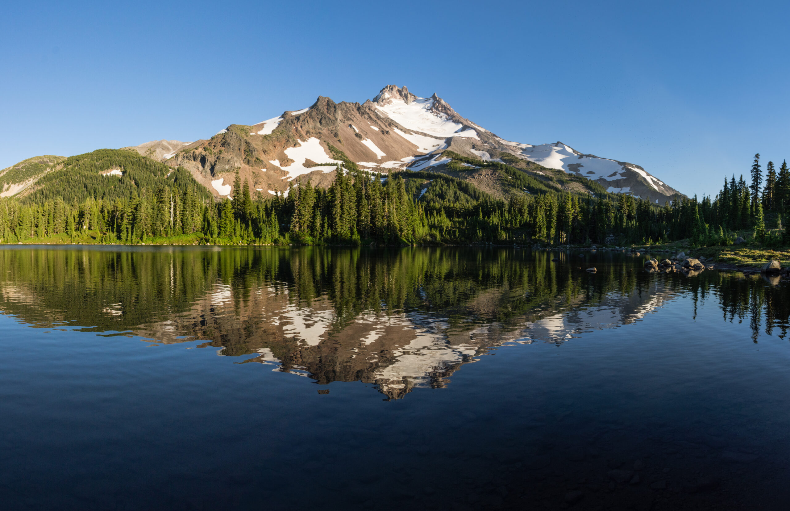
Oregon’s second-highest peak — and the state’s hardest to climb. Lower than Mount Hood, but far more committing: a long wilderness approach, glacier travel across the Whitewater Glacier, and a loose, exposed Class 4-5 summit pinnacle that turns many climbers back at the Red Saddle. This is the Pacific Northwest test piece.
Mount Jefferson (10,497 ft) is Oregon’s second-highest peak and its hardest — harder than the taller Mount Hood. The standard Whitewater Glacier route is a 17–22 mile, ~6,500 ft, 2–3 day trip that stacks a long wilderness approach, glacier travel, and a 400-foot summit pinnacle of loose, exposed Class 4–5 rock that has caused accidents and stops many climbers at the Red Saddle.
This is not a first Cascade volcano. Come with Hood, Adams, or St. Helens behind you, solid glacier and loose-rock skills, and the judgment to turn around. Do that, and Jefferson is the finest, most committing summit in Oregon — the peak that proves you’re ready for Rainier and beyond.
On this page
Find Hotels, Flights & Trips for the World’s Best Hiking Destinations
The Global Summit Guide Travel Shop on Expedia — curated for outdoor adventurers, mountaineers, and serious hikers. Patagonia to the Alps. Nepal to the Rockies. Curated lodging for every region we cover.
Explore Travel Shop on Expedia →Where it is
Central Oregon Cascades, ~60 miles east of Salem — staged from the Whitewater Trailhead.
Mount Jefferson rises in the Cascade Range of central Oregon, about 60 miles east of Salem and 90 miles southeast of Portland, straddling Jefferson, Linn, and Marion counties inside the Mount Jefferson Wilderness. The standard climb starts at the Whitewater Trailhead (4,100 ft), reached off Oregon Highway 22 near Detroit via Forest Road 2243. Portland (PDX) is the usual gateway airport.
The peak, in brief
Iconic, glaciated, and the most committing major peak in the state.
At 10,497 ft (3,199 m), Mount Jefferson is Oregon’s second-highest summit, after Mount Hood (11,249 ft). It’s a dormant Cascade stratovolcano — last erupted around 950 AD — with 5,777 ft of prominence, ranking it among the most prominent peaks in the contiguous US. Named by the Lewis and Clark Expedition in 1806, it carries several glaciers, the largest being the Whitewater Glacier on its east and northeast flanks. Where Hood draws thousands of climbers a year via a road nearly to timberline, Jefferson sees only hundreds — because reaching and climbing it is a serious mountaineering undertaking.
Why it’s Oregon’s hardest
Three difficulties stacked on top of each other — none of which Hood asks of you.
Jefferson’s reputation isn’t about altitude; it’s about what the mountain combines. Three factors together produce difficulty well beyond what a 10,497-foot summit suggests:
| The real challenge | Why it bites |
|---|---|
| The long wilderness approach | 17–22 miles round trip with ~6,500 ft of gain — far longer than Hood (8–10 mi) or Adams (12 mi). You carry a camp into Jefferson Park and climb over 2–3 days, not in a morning. Fatigue is a real factor before the technical ground even starts. |
| The Class 4–5 summit pinnacle | A ~400-foot tower of loose, friable volcanic rock — the crux of every ascent. It rewards competent rock skills and punishes complacency; rock loosens with each climber, so a helmet is essential and many parties rope up. |
| The Whitewater Glacier | The standard route crosses a retreating glacier that needs crampons, ice axe, a rope team, and crevasse-rescue competence. As it recedes it’s exposing more loose scree, which changes the route year to year. |
The Whitewater Glacier route
The standard line — about 80% of climbers — from trailhead to pinnacle.
Whitewater Glacier route
From the Whitewater Trailhead the route follows trail into Jefferson Park — one of the Cascades’ most beautiful alpine basins — for a high camp, then leaves the trail for glacier and loose rock to the summit. The stages:
| Trailhead → Jefferson Park (4,100 → ~5,900 ft) | ~5–6 mi of trail through forest (much of it burned in recent fires, so shade is limited) into the lake-dotted basin; camp near Scout Lake. |
| Jefferson Park → high bivy (~6,900 ft) | Off-trail travel around Point 6166 to a bivy ridge; faint climbers’ paths. |
| Bivy → Whitewater Glacier base (~7,500 ft) | Boulder fields and scree; transition to crampons at the ice. |
| Glacier crossing → Red Saddle (~9,800 ft) | Roped glacier travel (crevasses, especially late season), then a steep scree ridge to the saddle — the key turnaround decision point. |
| Summit pinnacle → summit (~10,100 → 10,497 ft) | ~400 ft of Class 4–5 climbing on loose volcanic rock; helmet essential. Summit views span Hood, the Three Sisters, and central Oregon. |
Summit day, hour by hour
A pre-dawn start from Jefferson Park — the pinnacle is no place for afternoon weather.
From a high camp around 5,900 ft, a typical summit day runs roughly 12–13 hours round trip:
| 2:00–3:00 a.m. | Wake and depart by headlamp; helmet and harness on. Boulder fields toward the glacier base. |
| ~4:30 a.m. | Whitewater Glacier base (~7,500 ft) — crampons on, rope team organized. |
| ~7:00 a.m. | Red Saddle (~9,800 ft) — glacier to scree ridge. Many turn back here for weather, fatigue, or loose-rock nerves. |
| ~9:30 a.m. | Summit (10,497 ft) after the Class 4–5 pinnacle. Brief stay; assess weather. |
| ~1:30 p.m. | Off the glacier; the descent of the loose pinnacle is often the hardest, most dangerous part when you’re tired. |
| ~3:30 p.m. | Back at high camp — then out to the trailhead that day or the next. |
Other routes
Quieter lines from Pamelia Lake, for solitude or more rock.
| Route | Start | Character |
|---|---|---|
| Whitewater Glacier | Whitewater TH | Standard; Grade II glacier + Class 4–5 pinnacle; ~80% of climbers |
| South Ridge | Pamelia Lake | ~18 mi; Grade II, Class 4; quieter, via a Shale Lake high camp |
| Southwest Ridge | Pamelia Lake | ~18 mi; Grade II–III; more rock, less glacier; experienced parties |
| Jefferson Park Glacier | Whitewater TH | A more glaciated variation from the Jefferson Park camp |
Permits & cost (2026)
Cheap to climb — but you must plan the permit around a limited-entry system.
- Overnight: $6 per group (up to 12). ~40% of quota releases the first Tuesday of April (April 7, 2026); the rest on a rolling 7-day window before your trip.
- Day use (Whitewater): $1 per person, released on a 10-day and 2-day rolling window — no advance full-season booking.
- Also required: a Northwest Forest Pass or day-use fee to park (the wilderness permit doesn’t cover parking).
| Item | 2026 cost | Notes |
|---|---|---|
| Overnight wilderness permit | $6 / group | Required for the standard 2–3 day climb |
| Northwest Forest Pass (parking) | $5/day or $30/yr | Separate from the wilderness permit |
| Self-guided climb (hard costs) | $50–$200 | Permits + transport + food for experienced climbers |
| Guided 3-day climb | $700–$1,800 | Regional operators; transport, permits, group gear, guide |
Self-guided, Jefferson is one of the best-value serious climbs anywhere — for comparison, guided Rainier runs $1,500–$3,500 and Hood $400–$800. There’s no summit fee; the real prerequisite is experience, not money.
Weather & when to climb
A short summer window — and a summit far colder than the valley.
Mid-July through mid-September is the window, once the snow consolidates on the glacier and the approach melts out; late July and August are peak. Early season (June) often still holds snow on the approach trail, and October–May is a serious winter mountaineering objective with a closed trailhead road and avalanche terrain. The live forecast below is for the Jefferson Park high camp and refreshes on load.
Jefferson Park high camp (~5,900 ft)
Loading live data…Gear essentials
Full glacier kit plus a light rock rack for the pinnacle.
- Glacier travel: crampon-compatible mountaineering boots, 12-point crampons, ice axe, harness, rope, and crevasse-rescue gear (prusiks, belay device, locking carabiners).
- For the pinnacle: a helmet (non-negotiable — rockfall on loose rock), and a small rock rack (a few nuts/small cams, slings) if you plan to protect the Class 4–5 climbing.
- Layers: base layers, fleece, insulated jacket, and a full hardshell (Gore-Tex top and bottom) — Cascade weather turns fast — plus warm hat and gloves.
- Backpacking kit: 55–75L pack, tent, sleeping bag rated to ~20°F, pad, stove, 3–4L water capacity and a filter, and a bear canister or hang.
- Essentials: headlamp + spares (for the 2 a.m. start), glacier glasses, sunscreen, navigation (map/GPS), first-aid, and an emergency bivy.
Name & history
From a sacred Cascade peak to a 19th-century first ascent.
Long before it had an English name, the mountain was sacred to the region’s Indigenous peoples — the Confederated Tribes of Warm Springs, the Molalla, and Northern Paiute among them — and appears in some traditions as Seekseekqua. On March 30, 1806, on the return leg of their expedition, William Clark named it for President Thomas Jefferson, who had commissioned the journey — extending American naming through a range where Mount Hood had been named by a British lieutenant in 1792.
The first documented ascent came in 1888, by R. L. Farmer and E. C. Cross, in the late-19th-century wave of Cascade first ascents. The Mount Jefferson Wilderness was designated in 1968. The modern era of the climb has been shaped by two forces: a run of wildfires (2017, 2020, 2024) that reshaped access and left burned forest along the approaches, and the Central Cascades Wilderness Permit system introduced in 2021 to manage a surge in visitors. Through all of it, the Whitewater Glacier route and its loose summit pinnacle remain what they’ve long been — the Oregon test piece.
Frequently asked questions
How hard is Mount Jefferson?
Oregon’s hardest peak — harder than the taller Hood. Grade II with glacier travel and a Class 4–5 loose summit pinnacle, run as a 17–22 mile, ~6,500 ft, 2–3 day trip. It needs glacier skills, loose-rock competence, and a head for exposure. Not a first Cascade volcano.
Do you need a permit?
Yes — a Central Cascades Wilderness Permit, June 15–Oct 15, for overnight and for day use at Whitewater. Overnight $6/group (40% release the first Tuesday of April, rest rolling 7 days out); day-use $1/person on 10-day/2-day rolling windows. Plus a Northwest Forest Pass to park.
What’s the summit pinnacle?
The ~400-foot crux of loose, friable Class 4–5 volcanic rock at the top. Helmet essential; many rope up; a lot of climbers turn back at the Red Saddle below it. It’s what makes Jefferson harder than Hood.
How long does it take?
A 2–3 day trip: ~6 miles to a Jefferson Park high camp, then a ~12–13 hour summit day from a 2 a.m. start. Only very fit parties do it car-to-car in one long day.
When should I go?
Mid-July to mid-September, peak late July–August. June often still holds snow; Oct–May is winter mountaineering. Always check current fire closures with the Willamette NF first.
How much does it cost?
Self-guided, roughly $50–$200 in hard costs (permit, parking pass, transport, food). Guided 3-day climbs run ~$700–$1,800. No summit fee — experience is the real prerequisite.
How we built this
Research-based. This guide draws on U.S. Forest Service (Willamette National Forest) and Recreation.gov 2026 permit information, standard Cascade route references, and documented Mount Jefferson history, cross-checked for elevation, route, permits, and season. We corrected a permit detail some sources get wrong: overnight reservations open the first Tuesday of April (April 7, 2026), not April 1, and Whitewater day-use permits release on a 10-day/2-day rolling window.
Fire closures, road access, and conditions change between seasons. Confirm current status with the Willamette National Forest and a mountain forecast before any attempt.
Climb Oregon’s test piece — prepared
Mount Jefferson rewards climbers who earn it: prior Cascade volcanoes, real glacier and loose-rock skills, a permit booked early, a 2 a.m. start, and the judgment to turn around at the Red Saddle. Do that, and it’s the finest summit in the state.
Start with Mount Hood → All Cascade volcanoes →Was this helpful?
🏔Related peaks nearby
🧭Explore & compare
Global Summit Guide is an independent mountaineering resource founded in 2026. The team combines first-hand trekking and climbing experience with in-depth research and professional health and nutrition review to help climbers choose objectives, prepare properly, and stay safe.
Health, altitude, and nutrition content is reviewed by Taylor Ludlow (Registered Nurse) and Brigg Hoopes (Nutritionist).
What We Don't Know Yet
Mountain information changes quickly. This box explains the limits of what this page can responsibly promise.
- Permit availability, reservation windows, quotas, and official fee rules may change after this page is updated.
- Guide-company prices, departure dates, guide ratios, included services, and cancellation rules can change without notice.
- Weather, snowpack, avalanche risk, road access, and route conditions can change quickly and may be different on your climbing dates.
- Route conditions, trailhead access, crevasse exposure, stream crossings, and rescue access may vary from published planning guidance.
- Total trip cost can change with flights, lodging, guide pricing, permits, gear rentals, transportation, and exchange rates.
Verify current conditions with official land managers, guide services, local forecasts, and current route reports before booking or climbing.
Part of this Global Summit Guide cluster
Explore the complete Mountains guide for more context, routes, planning links, and related resources.
Mountaineering, rock and ice climbing, glacier travel, and high-altitude activity are inherently dangerous and can result in serious injury or death. The information on Global Summit Guide is provided for general informational and educational purposes only and is not a substitute for professional instruction, qualified guiding, proper equipment, or your own judgment and experience.
Route conditions, weather, snowpack, permits, regulations, and hazards change constantly and may differ from what is described here. Details may be incomplete, out of date, or contain errors. Always verify current information with local authorities, certified guides, and official sources before making any decision in the mountains.
Nothing on this site is medical, legal, or financial advice. Our fitness, acclimatization, altitude, and nutrition content is general in nature; consult a qualified physician before beginning any strenuous exercise program or exposing yourself to high altitude.
You are solely responsible for your own safety and decisions. To the fullest extent permitted by law, Global Summit Guide and its team accept no liability for any loss, injury, damage, or expense arising from use of, or reliance on, this information. By using this site you acknowledge these risks and accept these terms.
Some links on this site may be affiliate links. If you buy through them we may earn a small commission at no extra cost to you; this never affects our recommendations.
Global Summit Guide recommendation path
Next Best Mountain to Research
Use these recommendations to continue the right planning path instead of stopping on one page.
Use current permit, weather, route, and operator information before booking or climbing.