
Climbing Panchchuli II: The Complete 2026 Southwest Ridge Route, Balati Plateau & Kumaon Himalaya Guide
Panchchuli II rises to 6,904 m (22,651 ft) above the Darma valley as the highest peak in the legendary Panchchuli massif. Furthermore, the iconic pyramid-shaped peak holds a unique place in Indian Himalayan mythology as one of the “Five Hearths” of the Pandava brothers from the Mahabharata.
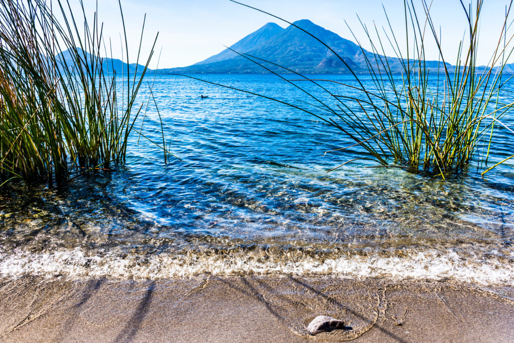
However, the peak’s significance extends well beyond its mythological origins. Specifically, Panchchuli II is considered one of the most beautiful peaks in the Himalaya. Subsequently, the perfect pyramid-shape attracts both serious mountaineers and ordinary observers from the famous Munsiyari hill station viewpoints.
The mountain stands as the centerpiece of a five-peak massif. Moreover, the Panchchuli peaks include I (6,355 m), II (6,904 m), III (6,312 m), IV (6,334 m), and V (6,437 m). Additionally, the peaks are numbered northwest to southeast — a naming tradition that breaks with the convention of giving the highest peak the lowest number.
First climbed on May 26, 1973 by 18 members of an Indo-Tibetan Border Police team led by Mahendra Singh, Panchchuli II then waited 18 years for its second ascent. Notably, the original ITBP expedition fixed almost 3,000 m of rope on the Southwest Ridge. Most modern expeditions take 28-32 days from Delhi via the Munsiyari approach.
For climbers seeking technical Kumaon Himalayan climbing, Panchchuli II offers exceptional opportunities. Additionally, the famous 1992 Indo-British expedition jointly led by Chris Bonington and Harish Kapadia successfully repeated the Southwest Ridge route. Furthermore, the same expedition made the first ascent of Panchchuli V via the south ridge.
This complete 2026 guide covers verified route descriptions, current permit requirements, gear lists, hazard analysis, seasonal timing, costs across budget tiers, expedition history including all major routes, and essential safety protocols. Furthermore, every detail reflects 2026 conditions confirmed through Indian Mountaineering Foundation, Uttarakhand state authorities, and registered Indian operators.
Live Panchchuli II Operations Center
Real-time location intelligence and Munsiyari base region weather conditions
Panchchuli II stands as the crown jewel of the legendary Five Hearths massif, rising 6,904 meters above the Darma valley in eastern Kumaon, Uttarakhand, India. Furthermore, the iconic pyramid-shaped peak holds a unique place in Indian Himalayan mythology as one of the cooking hearths of the Pandava brothers from the Mahabharata.
However, the peak’s significance extends well beyond its mythological origins. Specifically, Panchchuli II is considered one of the most beautiful peaks in the entire Himalaya. Subsequently, the perfect pyramid-shape attracts both serious mountaineers and ordinary observers from the famous Munsiyari hill station viewpoints.
The mountain stands as the centerpiece of a five-peak massif. Moreover, the Panchchuli peaks include I (6,355 m), II (6,904 m), III (6,312 m), IV (6,334 m), and V (6,437 m). Additionally, the peaks are numbered northwest to southeast — a naming tradition that breaks with the convention of giving the highest peak the lowest number.
Despite ranking as the highest peak in the Panchchuli group, this mountain commands respect through its technical challenges and remote location. Notably, the original 1973 ITBP expedition fixed almost 3,000 m of rope on the Southwest Ridge route. Most modern expeditions take 28-32 days from Delhi via the Munsiyari approach.
Panchchuli II sits on the Gori Ganga-Lassar Yankti divide near Dugtu village in the Darma valley. Additionally, the massif lies 138 km from Pithoragarh forming the watershed between the Gori and Darma Ganga valleys. Furthermore, the eastern approaches go through Sona and Meola Glaciers while the western approaches use the Uttari and Dakshini Balati glaciers — the latter once named a “death trap” by 1950s expeditions.
First climbed by Mahendra Singh’s ITBP team in 1973 and famously revisited by the 1992 Bonington-Kapadia Indo-British expedition, Panchchuli II represents one of the most respected technical climbing destinations in the Indian Himalaya.
The Southwest Ridge route from the Balati Plateau remains the recommended approach for most expeditions. Specifically, this route follows the historic 1973 Mahendra Singh ITBP first ascent line. Furthermore, the established camp progression provides safe acclimatization across multiple high camps. Additionally, the route rewards climbers with iconic views of the entire Panchchuli massif and the Kumaon Himalaya. Notably, the original expedition fixed almost 3,000 m of rope on this route — testament to its technical demands.
Panchchuli II’s western approach historically presents serious objective hazards. Specifically, 1950s expeditions named the Dakshini Balati glacier a “death trap” due to its ferocious icefall. Moreover, the 1992 Bonington-Kapadia expedition found the icefall approach to the upper Balati Plateau objectively dangerous. Additionally, in 2003 a tragic ITBP expedition lost nine members in an avalanche while descending after a successful summit attempt. Therefore, climbers must carefully assess objective hazards on all Panchchuli II routes.
This guide consolidates information from the Indian Mountaineering Foundation (IMF), Uttarakhand state forest department, ExplorersWeb climbing history archives, American Alpine Journal historical reports, The Himalayan Journal HJ/48/7 expedition documentation, registered Indian operators, Harish Kapadia’s published mountaineering accounts, and verified expedition reports including the 1992 Bonington-Kapadia Indo-British expedition. Additionally, all elevations, route grades, costs, and permit requirements reflect 2026 conditions confirmed through April 2026.
At a Glance: Panchchuli II Essentials
Panchchuli II presents specific characteristics among the major Kumaon Himalaya peaks. Furthermore, the following statistics summarize what climbers must prepare for. Specifically, every parameter below reflects 2026 conditions verified through Indian Mountaineering Foundation and registered Indian operators.
Eight Reasons Climbers Choose Panchchuli II
Panchchuli II holds a unique position as the highest of the legendary Five Hearths in the Kumaon Himalaya. Furthermore, the following reasons explain why serious alpinists target this peak. Importantly, each motivation also carries an associated responsibility for safe execution at extreme altitude.
Pandavas’ Five Hearths Heritage
Panchchuli II forms one of the five legendary cooking hearths where the Pandava brothers from the Mahabharata cooked their last meal before ascending to heaven. Furthermore, this gives the peak profound spiritual significance in Hindu tradition.
Highest of Panchchuli Group
Panchchuli II ranks as the highest peak in the five-peak massif at 6,904 m. Subsequently, the peak commands prominence over Panchchuli I, III, IV, and V despite its non-traditional second-position numbering.
Pyramid-Shaped Beauty
Panchchuli II is considered one of the most beautiful peaks in the Himalaya. Specifically, the perfect pyramid shape inspires awe from Munsiyari and other Kumaon hill station viewpoints.
Historic ITBP First Ascent
The May 26, 1973 first ascent represented historic Indian achievement. Moreover, 18 climbers reached the summit — a remarkably large summit team for any major Himalayan peak — fixing nearly 3,000 m of rope.
Bonington-Kapadia Connection
The famous 1992 Indo-British expedition jointly led by Chris Bonington and Harish Kapadia successfully climbed Panchchuli II. Notably, this brought international attention to the entire Kumaon region’s climbing potential.
Munsiyari Hill Station Views
Panchchuli II provides the centerpiece view from Munsiyari hill station. Specifically, the peak appears in spectacular sunrise and moonrise photographs from the famous Wayfarer Himalaya Lodge viewpoints.
Multiple Established Routes
Panchchuli II features the historic Southwest Ridge plus eastern approaches via Sona and Meola Glaciers. Additionally, the 1991 Indian Army expeditions completed Hugh Ruttledge’s 1929 route via the northeast slopes after 61 years.
Less-Visited Eastern Kumaon
Panchchuli II offers solitude away from the popular Garhwal Himalaya routes. Moreover, the remote Pithoragarh District location attracts climbers seeking authentic adventure beyond standard Indian Himalaya itineraries.
Who Can Climb Panchchuli II
Panchchuli II demands serious technical mountaineering experience. Specifically, the standard Southwest Ridge route requires solid 6,000+ m experience, technical mixed climbing skills, fixed rope technique, and tolerance for sustained exposure. Furthermore, climbers should have prior Himalayan expedition experience or join a fully guided team with experienced support staff.
The standard route gains approximately 2,400 m from base camp to the summit. Therefore, a climber comfortable with technical multi-week expedition logistics has the foundation for Panchchuli II. However, raw fitness alone will not protect against altitude effects, weather changes, or technical demands at extreme altitude.
Beginners to high-altitude expeditions should not target Panchchuli II. Subsequently, the peak requires substantial expedition logistics and technical climbing experience. Importantly, completing prior 6,000 m peaks like Stok Kangri or Kang Yatse provides essential preparation, though Panchchuli II demands more technical skill than these standard objectives.
For climbers seeking eastern approach routes, requirements escalate dramatically. Moreover, attempting routes via the Sona Glacier or Meola Glacier requires elite technical capabilities including ice climbing, mixed climbing, and serious objective hazard assessment. Additionally, the 2003 ITBP avalanche tragedy reminds climbers of consequences at this elevation.
The IMF emphasizes that all Panchchuli II permits require advance coordination through registered Indian operators. Notably, established operators send experienced support teams that handle approach logistics and base camp infrastructure. Furthermore, the historic 1973 ITBP expedition established the route knowledge still used today. Therefore, partnering with experienced Indian operators provides essential expedition support throughout the multi-week climb on this technically demanding peak in remote eastern Kumaon.
Panchchuli II in Kumaon Himalaya Context
Panchchuli II occupies a strategic position as the highest peak in the Panchchuli massif. Specifically, the peak rises in eastern Kumaon as part of the watershed between the Gori Ganga and Darma valleys. Additionally, the mountain stands among the prominent peaks of the Kumaon Himalaya alongside Nanda Kot, Trisul, and Hardeol.
For climbers planning regional trips, Panchchuli II pairs naturally with several nearby Indian Himalaya peaks. Furthermore, the four sister Panchchuli peaks provide technical alternatives in the same massif. Additionally, Nanda Kot (6,861 m) offers another Kumaon option. Moreover, Hardeol (7,151 m) provides the next progression target above 7,000 m in eastern Kumaon.
The Indian Himalaya Companion Peaks
Panchchuli II shares the Indian Himalaya with several other classic peaks. Furthermore, all six peaks below provide alternative or progression objectives accessible from regional base camps.
Panchchuli II History: From 1929 British Reconnaissance to Modern Era
Panchchuli II’s recorded climbing history spans nearly 100 years and reflects significant chapters in Kumaon Himalaya exploration. Ultimately, few peaks combine such early reconnaissance significance with continued status as a respected technical destination. Specifically, the mountain played a foundational role in establishing the Panchchuli massif as a major climbing region.
1929: Hugh Ruttledge Reconnaissance
British mountaineer Hugh Ruttledge began the documented mountaineering history of the Panchchuli peaks in 1929. Specifically, he saw the group at close quarters from high up on the Sona Glacier. Additionally, Ruttledge examined the routes and thought that the north arete might be possible. Furthermore, his reconnaissance established the foundation for all subsequent Panchchuli climbing attempts.
1950: Murray Scottish Expedition Attempt
WH Murray and his Scottish team attempted Panchchuli II in 1950 by following the Ruttledge route. Specifically, they intended to reach the north col and follow the northeast ridge. However, they found the terrain too difficult to continue safely. Additionally, this established the difficulty of the eastern approaches that would defeat multiple attempts in the following decades.
1950s: Multiple Failed Attempts
Multiple expeditions attempted Panchchuli II throughout the 1950s without success. Specifically, one expedition rightly named the Dakshini Balati glacier a “death trap” seeing its ferociousness. Additionally, this established the western approaches as objectively dangerous routes. Subsequently, the peak remained unclimbed despite numerous attempts during this exploration era.
1972: ITBP First Ascent of Panchchuli I
An Indo-Tibetan Border Police team led by Major Hukam Singh made the first-ever ascent of Panchchuli I in 1972 via the Uttari Balati glacier. Specifically, they powered their way to the Balati Plateau via the Harrer route. Additionally, this established the western approach infrastructure that would enable the 1973 Panchchuli II first ascent. Furthermore, Hukam Singh would go on to lead the first ascent of Shivling in 1974.
May 26, 1973: ITBP Panchchuli II First Ascent
An Indo-Tibetan Border Police expedition led by Mahendra Singh made the historic first ascent on May 26, 1973. Specifically, 18 climbers reached the summit — a remarkably large summit team for any major Himalayan peak. Additionally, the team fixed almost 3,000 m of rope on the Southwest Ridge route from the Balati Plateau. Furthermore, the climb established the standard route still used today.
1991: Indian Army Eastern Approach Success
Two Indian Army expeditions completed eastern approaches in 1991, ending Panchchuli II’s 18-year second-ascent drought. Specifically, the Kumaon and Naga Regiment team followed the Sona Glacier and northeast slopes to reach above the north col. Additionally, this completed the route originally suggested by Ruttledge in 1929 — finally achieved 61 years later. Furthermore, Dan Singh, Rajendra Singh, Chander Singh, and Capt. Ganesh Pathak made the summit.
1991: Second Indian Army Expedition
The second Indian Army expedition in 1991 followed Murray’s 1950 route to the upper Meola Glacier. Specifically, they pitched a high camp following the southeast slopes to the east ridge. Additionally, this opened another previously unsuccessful eastern route. Subsequently, both 1991 ascents demonstrated viable alternatives to the original Southwest Ridge.
May-June 1992: Indo-British Bonington-Kapadia Expedition
An Indo-British expedition jointly led by Chris Bonington and Harish Kapadia successfully repeated the Southwest Ridge route in 1992. Specifically, the third expedition of Kapadia’s Indo-British ventures took place between May 10 and June 29. Additionally, three Indian members reached the summit. Furthermore, the same expedition made the first ascent of Panchchuli V via the south ridge.
1995: New Zealand Panchchuli IV First Ascent
A New Zealand expedition led by John Nankervis made the first ascent of Panchchuli IV (6,334 m) in 1995. Specifically, summiteers John Nankervis, Peter Cammell, John Cocks, and Nick Shearer reached the top. Additionally, Peter Platts assisted as far as Camp 2. Subsequently, this opened another major Panchchuli peak after years of inactivity in the massif.
September 20, 2003: Tragic ITBP Avalanche
One of the worst avalanche tragedies in Himalayan mountaineering history occurred in 2003. Specifically, nine members of an Indo-Tibet Border Police team to Panchchuli II were killed while descending the mountain on September 20 after a successful summit attempt. Additionally, the team appears to have climbed the Southwest Ridge route. Tragically, the expedition was attempting the mountain before the end of the monsoon, reported to be comparatively heavy that year.
Climbing Routes on Panchchuli II
Panchchuli II features multiple established climbing routes across its faces and ridges. Specifically, the standard Southwest Ridge from the Balati Plateau dominates climbing traffic. Furthermore, eastern approach alternatives include the Northeast Ridge via Sona Glacier and the East Ridge via Meola Glacier. Additionally, all routes require IMF permits and registered operator coordination.
| Route | First Ascent | Grade | Length | Year | Style |
|---|---|---|---|---|---|
| Southwest Ridge (Standard) | Mahendra Singh ITBP team | D+ | ~3,000 m fixed rope | 1973 | Standard route |
| Northeast Ridge via Sona Glacier | Indian Army (Kumaon/Naga) | TD | ~1,500 m | 1991 | Eastern approach |
| East Ridge via Meola Glacier | Second Indian Army team | TD | ~1,500 m | 1991 | Murray’s route |
| Southwest Ridge Repeat | Bonington-Kapadia Indo-British | D+ | ~1,500 m | 1992 | Second ascent route |
Southwest Ridge — Mahendra Singh 1973 First Ascent Line
The Southwest Ridge Route represents the standard climbing approach on Panchchuli II. Specifically, climbers begin from Munsiyari via Dharchula and Sobala. Moreover, the approach trek takes 5-7 days through Sela, Duktu, and traditional Kumaon villages along the Darma Ganga river. Additionally, base camp is established at approximately 4,000 m near Dugtu village.
From base camp, the route ascends through complex glacier terrain via the Uttari Balati glacier to the Balati Plateau. Subsequently, expeditions establish multiple high camps at progressively higher elevations. Additionally, the team practices climbing equipment use and conducts acclimatization rotations. Furthermore, this section follows the exact line used by Hukam Singh’s 1972 ITBP team and Mahendra Singh’s 1973 expedition.
The route reaches the Southwest Ridge from the Balati Plateau. Additionally, this critical waypoint provides access to the upper summit. Notably, the original 1973 expedition fixed almost 3,000 m of rope on this route — testament to its technical demands. Consequently, the Southwest Ridge offers genuine Himalayan summit experience while remaining the most established Panchchuli II line.
The summit push features technical mixed climbing with significant exposure. Moreover, climbers face combinations of rock, ice, and snow climbing throughout. Notably, lack of oxygen at altitude seriously hampers climbers throughout the summit push. Consequently, the Southwest Ridge route stands as the safest established Panchchuli II ascent line, requiring exceptional fitness and acclimatization.
Northeast Ridge via Sona Glacier — Kumaon Naga Regiment 1991
The Northeast Ridge route via Sona Glacier was first completed by the Indian Army Kumaon and Naga Regiment expedition in 1991. Specifically, the team followed the Sona Glacier and climbed the northeast slopes to reach above the north col. Additionally, the ridge was followed to the top, completing the route originally suggested by Hugh Ruttledge in 1929 — finally achieved 61 years later.
This route demands elite eastern approach capabilities. Furthermore, modern attempts require advanced rock climbing, ice climbing, and high-altitude expedition tactics. Additionally, summiteers Dan Singh, Rajendra Singh, Chander Singh, and Capt. Ganesh Pathak became the first to climb Panchchuli II from the eastern face and eastern direction. Consequently, the route remains a respected alternative to the standard Southwest Ridge.
East Ridge via Meola Glacier — Indian Army 1991
The East Ridge route via Meola Glacier was first completed by the second Indian Army expedition in 1991. Specifically, the team followed Murray’s 1950 route to the upper Meola Glacier. Additionally, they pitched a high camp following the southeast slopes to the east ridge. Subsequently, this completed the route attempted unsuccessfully by Murray’s Scottish team 41 years earlier.
This route maintains significance for Panchchuli II alpinism. Furthermore, modern attempts require advanced rock climbing, ice climbing, and route-finding skills. Additionally, the East Ridge offers another eastern approach alternative to the standard Southwest Ridge. Consequently, this route requires elite alpine experience for safe execution at high altitude.
Southwest Ridge — Indo-British 1992 Second Ascent
The Southwest Ridge second ascent by the Indo-British expedition jointly led by Chris Bonington and Harish Kapadia was completed in 1992. Specifically, three Indian members repeated the historic 1973 route. Additionally, the expedition took place between May 10 and June 29, 1992. Furthermore, the team found the icefall approach to the upper Balati Plateau objectively dangerous.
This route demonstrates continued international interest in the standard Panchchuli II line. Furthermore, the same 1992 expedition also made the first ascent of Panchchuli V via the south ridge. Additionally, the Indo-British venture represented Kapadia’s third such collaboration. Consequently, the 1992 expedition opened a new era of international climbing on the Panchchuli massif.
Panchchuli II Access & Permits 2026
Panchchuli II requires comprehensive permits in 2026 from multiple Indian authorities. Specifically, all climbers need Indian Mountaineering Foundation permits, Uttarakhand state permits, and Inner Line Permits for the restricted Kumaon border region. Furthermore, the IMF processes climbing permits in coordination with the Forest Department and District Magistrate for sensitive border zone access.
Panchchuli II permits require advance application 3-4 months before expedition. Specifically, the IMF coordinates with Uttarakhand Forest Department and Pithoragarh District Magistrate for Inner Line Permits. Additionally, registered Indian operators handle the full permit coordination including Liaison Officer assignment. Moreover, the climbing season runs primarily May through October with weather windows in May-June and September-October. Furthermore, weekend dates fill first as Indian and international teams compete for limited expedition slots.
Required Documentation for 2026
- IMF climbing permit: Indian Mountaineering Foundation expedition permit
- Uttarakhand forest permit: State-level access permit for Kumaon Himalaya
- Inner Line Permit (ILP): Required for restricted Indo-Tibetan border region
- Liaison Officer: IMF-assigned officer accompanies all expeditions
- Registered operator coordination: Mandatory for all climbing expeditions
- High-altitude insurance: Mandatory including helicopter rescue coverage
- Indian visa: Tourist or expedition visa for foreign climbers
2026 Permit Cost Breakdown
- IMF Peak Booking Fee: USD 1,000-1,500 per expedition team
- Uttarakhand forest permit: USD 200-400 per expedition
- Inner Line Permit fees: USD 100-200 per climber
- Liaison Officer fees: USD 1,500-2,500 for full expedition duration
- Registered operator base fees: USD 10,000-20,000 per climber depending on services
- High-altitude insurance: USD 600-1,200 per climber minimum
Access Logistics from Delhi
Panchchuli II is accessible from Delhi via train and road. Specifically, expeditions typically take overnight train from Delhi to Kathgodam, then road transfer to Munsiyari (2,200 m). Additionally, the journey covers approximately 750 km from Delhi to Munsiyari over 2-3 days. Moreover, base camp area requires 5-7 days approach trekking via Dharchula, Sobala, Sela, and Duktu villages along the Darma Ganga river. Consequently, plan substantial travel time including IMF de-briefing in Delhi at expedition end.
Panchchuli II Climbing Costs in 2026
Panchchuli II expedition costs vary based on guide service level and team size. Specifically, fully guided standard route expeditions run USD 15,000-28,000 per person. Furthermore, group rates with 4-6 climbers reduce per-person costs significantly. Additionally, technical eastern approach attempts cost dramatically more due to specialized logistics. All costs reflect 2026 conditions verified through registered Indian operators.
Group Guided Southwest Ridge Expedition (6+ climbers)
The most affordable Panchchuli II expedition option involves group climbs with 6 or more climbers per registered Indian operator. Furthermore, costs include IMF permits, Liaison Officer fees, registered operator services, climbing guides, support staff, fixed ropes, food, and base camp logistics. Specifically, this tier provides solid value for clubs and larger teams attempting the standard Southwest Ridge route.
Standard Guided Expedition (4-5 climbers)
Most international climbers select the standard guided expedition format for the Southwest Ridge route. Additionally, this tier provides personalized attention with experienced support staff. Specifically, the cost includes complete logistics from Delhi reception through expedition completion. Furthermore, this represents the typical cost for serious Panchchuli II standard route attempts.
Premium Small Team Expedition (2-3 climbers)
Premium small team expeditions provide higher staff-to-climber ratios for maximum support. Additionally, this tier includes priority weather forecasting, premium gear options, and enhanced base camp facilities. Notably, smaller teams move more efficiently through high camps. Consequently, this option suits experienced climbers seeking optimal support for personal Panchchuli II success on the standard route.
Sona or Meola Glacier Eastern Approach
Eastern approach expeditions via the Sona Glacier or Meola Glacier require dramatically extended timelines and specialized logistics. Moreover, the program includes additional days for technical climbing, weather windows, and complex glacier travel. Subsequently, this comprehensive approach maximizes summit success probability for serious technical teams seeking alternative routes. Additionally, the attempt requires specialized hardware and elite Alpine expertise.
Custom Private Expedition with Combination Peaks
Custom private expeditions provide maximum flexibility and luxury services. Furthermore, climbers can combine Panchchuli II with sister peaks like Panchchuli I, V, or attempt Panchchuli III (still unclimbed by some accounts). Notably, this includes options for new line attempts on subsidiary aspects or alternate seasonal windows. Consequently, custom expeditions suit experienced alpinists seeking specific Panchchuli II experiences beyond standard packages.
Essential Gear for Panchchuli II Expedition
Gear requirements for Panchchuli II reflect serious technical 6,904 m expedition demands. Specifically, the standard Southwest Ridge route requires full high-altitude expedition equipment including technical mixed climbing gear. Furthermore, climbers should bring quality gear suitable for 28-32 day expedition conditions with severe Himalayan weather. Additionally, every essential item below reflects current Indian Mountaineering Foundation expedition standards.
High-Altitude Boots (Mandatory)
- Triple-layer boots rated for -25°C minimum
- La Sportiva G2 Evo or Scarpa Phantom 6000
- Compatible with 12-point automatic crampons
- Break in thoroughly before expedition
Climbing Hardware (Mandatory)
- 12-point automatic crampons
- Two technical ice axes for steep mixed sections
- Climbing harness with adjustable leg loops
- Ascender (jumar) for fixed ropes
Ropes & Protection (Mandatory)
- 60-meter dynamic glacier rope (8.5-9 mm)
- 4-6 ice screws (varied lengths 13-19 cm)
- Snow pickets and pitons for fixed rope anchors
- Rock protection for technical sections
Down Jacket and Insulation
- Heavy down jacket for summit push
- 800-fill or higher down rating
- Synthetic backup insulation layer
- Down booties for camp use
Sleeping System
- Sleeping bag rated to -25°C minimum
- Closed-cell foam pad plus inflatable
- Vapor barrier liner for warmth
- Quality pillow for high-altitude rest
Tents and Shelter
- Wind-resistant high-altitude tents (provided by operator)
- Personal sleeping pad and bivy options
- Down booties and camp slippers
- Personal entertainment for weather days
Navigation and Safety
- GPS device or smartphone with offline maps
- Topographic maps of Kumaon region
- Headlamp with multiple battery sets for early starts
- Satellite communicator (InReach mandatory)
Personal and Medical
- Comprehensive expedition first aid kit
- Diamox for altitude prophylaxis
- Personal medications for full duration
- Sunscreen SPF 50+ and lip protection
Hazards on Panchchuli II
Panchchuli II presents serious hazards typical of remote technical 6,900 m Himalayan peaks. Specifically, the icefall approaches and avalanche-prone slopes account for many documented incidents. Furthermore, climbers must assess each hazard category honestly before any Panchchuli II expedition.
Avalanche Hazards on Descent
Panchchuli II’s descent routes present serious avalanche hazards as demonstrated by the 2003 ITBP tragedy. Specifically, nine ITBP team members were killed by an avalanche while descending after a successful summit attempt on September 20, 2003. Additionally, the team had attempted the mountain before the end of the monsoon. Subsequently, modern attempts must respect seasonal timing carefully.
Dakshini Balati Glacier “Death Trap”
The Dakshini Balati glacier earned the name “death trap” from 1950s expeditions due to its ferocious icefall. Specifically, the western approach traverses dangerous glacier terrain throughout. Additionally, this hazard contributed to multiple failed attempts during the 1950s exploration era. Furthermore, modern teams must time movements around safe weather windows.
Balati Plateau Icefall Approach
The 1992 Bonington-Kapadia expedition found the icefall approach to the upper Balati Plateau objectively dangerous. Specifically, the route involves complex serac and crevasse navigation. Additionally, even experienced expedition teams report serious objective hazards on this approach. Subsequently, climbers must travel as roped parties with constant vigilance.
Crevasse Hazards on Approach Glaciers
The approach glaciers contain extensive crevasse fields requiring careful rope team travel. Specifically, snow bridges become unstable during warm weather and afternoon melt cycles. Furthermore, climbers must travel as roped parties throughout all glacier sections. Moreover, advanced crevasse rescue knowledge represents an absolute prerequisite for any climb.
Technical Mixed Climbing Above 6,000 m
Above the high camps, climbers face technical mixed terrain combining rock, ice, and snow. Specifically, even the standard route requires technical skills not typical of basic 6,000 m peaks. Additionally, the eastern approach routes demand elite alpine capabilities. Therefore, climbers need solid technical alpine experience before attempting Panchchuli II.
Monsoon and Weather Variability
The Indian monsoon affects Panchchuli II region from late June through August. Moreover, pre-monsoon (May-June) and post-monsoon (September-October) provide the climbing windows. Additionally, weather changes rapidly above 6,000 m. Furthermore, the famous 1973 first ascent occurred on May 26, demonstrating early summer’s potential when monsoon timing has not yet affected conditions.
Safety Protocols for Panchchuli II
Successful Panchchuli II expeditions depend on conservative decision-making and disciplined technical execution. Furthermore, the most experienced Indian operators emphasize that turning back is a victory when conditions deteriorate. Specifically, climbers should establish hard turnaround times and honor them regardless of summit proximity.
File detailed itineraries with both your registered Indian operator and embassy. Additionally, carry comprehensive satellite communications including InReach for emergency response. Notably, Indian Air Force coordinates high-altitude rescue operations through Indian Mountaineering Foundation channels. Furthermore, knowing advanced crevasse rescue, partner-rescue, and self-rescue techniques can mean the difference between minor incidents and fatal outcomes at extreme altitude on technical terrain — as the 2003 ITBP tragedy reminds all climbers.
When to Climb Panchchuli II
Seasonal timing on Panchchuli II determines both safety and success rates. Specifically, the Indian monsoon dominates climate considerations from late June through August. Furthermore, the climbing windows fall in pre-monsoon and post-monsoon periods, requiring careful attention to monthly conditions.
Spring Pre-Monsoon (May to early June)
Late spring offers the primary pre-monsoon climbing window. Furthermore, snow conditions remain firm and stable from winter accumulation. Specifically, this period provides the best weather windows for technical climbing on Panchchuli II. Additionally, the famous 1973 first ascent occurred on May 26, demonstrating early summer’s potential. Moreover, the 1992 Bonington-Kapadia expedition climbed during May-June within this window.
Monsoon Period (Late June to August)
The Indian monsoon shuts down most climbing activity on Panchchuli II. Moreover, heavy precipitation and unstable weather make summit attempts dangerous. However, base camp and lower acclimatization activities can proceed during weather windows. Furthermore, the monsoon period sees increased avalanche risk as demonstrated by the 2003 ITBP tragedy occurring in late September.
Post-Monsoon (September to October)
The post-monsoon period provides the second major climbing window. Notably, stable high-pressure systems often bring excellent climbing weather. Subsequently, this period also rewards climbers with longer daylight than spring. Additionally, autumn provides clearer Kumaon range views from the summit. However, climbers must respect that 2003 saw a heavier monsoon and the resulting ITBP tragedy on September 20.
Winter (November to April)
Winter conditions effectively close Panchchuli II to expedition activity. Furthermore, extreme cold and severe weather make technical climbing unrealistic. However, the technical nature of Panchchuli II makes winter attempts especially dangerous. Additionally, modern winter ascents have not been recorded.
Notable Expeditions and Climbs
Panchchuli II’s climbing history features remarkable individual achievements alongside the famous 1973 first ascent. Furthermore, each notable expedition below contributed essential knowledge to modern Panchchuli II climbing practice. Specifically, the expeditions span nearly 100 years of evolving Kumaon Himalaya climbing culture.
Hugh Ruttledge Reconnaissance
First Documented VisitBritish mountaineer Hugh Ruttledge began the documented mountaineering history of the Panchchuli peaks. Specifically, he saw the group at close quarters from high up on the Sona Glacier. Additionally, Ruttledge examined the routes and thought that the north arete might be possible.
Murray Scottish Expedition
Terrain Too DifficultWH Murray and his Scottish team attempted Panchchuli II by following the Ruttledge route. Specifically, they intended to reach the north col and follow the northeast ridge. However, they found the terrain too difficult to continue safely.
ITBP First Ascent
First AscentMahendra Singh led the Indo-Tibetan Border Police team to the historic first ascent. Specifically, 18 climbers reached the summit via the Southwest Ridge from the Balati Plateau. Additionally, the team fixed almost 3,000 m of rope on the route — testament to its technical demands.
Indian Army Eastern Approach
Completes Ruttledge RouteThe Indian Army Kumaon and Naga Regiment expedition completed the route originally suggested by Ruttledge in 1929. Specifically, summiteers Dan Singh, Rajendra Singh, Chander Singh, and Capt. Ganesh Pathak climbed via the Sona Glacier and northeast slopes after 61 years.
Bonington-Kapadia Indo-British
Second Ascent + Panchchuli V FAThe Indo-British expedition jointly led by Chris Bonington and Harish Kapadia successfully repeated the Southwest Ridge. Specifically, three Indian members reached the summit. Additionally, the same expedition made the first ascent of Panchchuli V via the south ridge.
September 2003 ITBP Tragedy
9 Killed in AvalancheOne of the worst avalanche tragedies in Himalayan mountaineering history. Specifically, nine ITBP team members were killed while descending after a successful summit attempt. Tragically, the expedition was attempting the mountain before the end of a comparatively heavy monsoon season.
Planning Your 2026 Panchchuli II Expedition
Successful Panchchuli II planning combines logistics, training, and conditioning across multiple months. Furthermore, the following planning categories cover every essential element climbers must address. Additionally, each card represents a critical preparation area for any 2026 attempt.
Panchchuli II Frequently Asked Questions
How tall is Panchchuli II?
Panchchuli II rises to 6,904 m (22,651 ft) in the eastern Kumaon Himalaya of Uttarakhand, India. Specifically, the peak ranks as the highest of the five Panchchuli peaks. Furthermore, the Panchchuli massif includes peaks I (6,355 m), II (6,904 m), III (6,312 m), IV (6,334 m), and V (6,437 m). Additionally, the peaks are numbered northwest to southeast — a naming tradition that breaks with the convention of giving the highest peak the lowest number.
Where is Panchchuli II located?
Panchchuli II sits in the Pithoragarh District of Uttarakhand, India, at the eastern end of the Kumaon Himalaya. Specifically, the peak rises near Dugtu village in the Darma valley. Additionally, the massif lies 138 km from Pithoragarh on the Gori Ganga-Lassar Yankti divide. Furthermore, the mountain coordinates are approximately 30.2142°N, 80.4275°E. Moreover, the peak forms the watershed between the Gori and Darma Ganga valleys.
How difficult is climbing Panchchuli II?
Panchchuli II grades technically demanding for an extremely serious mountaineering objective. Specifically, the standard Southwest Ridge route requires solid 6,000+ m experience, technical mixed climbing skills, and tolerance for sustained exposure. Additionally, the original 1973 first ascent fixed almost 3,000 m of rope on the southwest ridge. Furthermore, the eastern approaches via Sona and Meola Glaciers offer demanding alternative routes. Moreover, expeditions typically take 28-32 days from Delhi to summit and back.
Who first climbed Panchchuli II?
An Indo-Tibetan Border Police (ITBP) team led by Mahendra Singh made the first ascent on May 26, 1973 via the Southwest Ridge from the Balati Plateau. Specifically, 18 climbers reached the summit — a remarkably large summit team for any major Himalayan peak. Additionally, the team fixed almost 3,000 m of rope on the route. Furthermore, the climb followed the route established by Hukam Singh’s 1972 ITBP first ascent of Panchchuli I via the Harrer route.
What is the famous 1992 Bonington-Kapadia expedition?
In May-June 1992, an Indo-British expedition jointly led by Chris Bonington and Harish Kapadia successfully climbed Panchchuli II. Specifically, three Indian members repeated the 1973 Southwest Ridge route. Additionally, the same expedition made the first ascent of Panchchuli V (6,437 m) via the south ridge. Furthermore, the team found the icefall approach to the upper Balati Plateau objectively dangerous.
Do I need a permit to climb Panchchuli II?
Yes, all Panchchuli II climbers must obtain permits from the Indian Mountaineering Foundation (IMF) and Uttarakhand state government. Specifically, the permit application process takes 3-4 months. Additionally, climbers also need Inner Line Permits (ILP) for the restricted Kumaon border region. Furthermore, registered Indian operator coordination is mandatory for all expedition logistics. Moreover, the IMF Peak Booking Fee for foreign nationals is approximately USD 1,000-1,500 per expedition team.
What is the best time to climb Panchchuli II?
The optimal climbing season runs from May through October. Specifically, pre-monsoon (May-June) and post-monsoon (September-October) provide the best weather windows. Additionally, the Indian monsoon affects the region from late June through August. Furthermore, the famous 1973 first ascent occurred on May 26 and the 1992 Bonington-Kapadia expedition during May-June. Moreover, expeditions must time summit attempts around stable weather windows due to extreme weather variability.
How much does it cost to climb Panchchuli II in 2026?
Panchchuli II expeditions cost USD 15,000-28,000 per person for fully guided programs. Specifically, the cost includes IMF permits, registered operator services, climbing guides, technical climbing support, fixed ropes, and base camp logistics. Additionally, group rates with 4-6 climbers reduce per-person costs to USD 12,000-18,000. Furthermore, technical eastern approach routes via Sona Glacier cost significantly more due to specialized logistics and longer durations.
What is the meaning of Panchchuli?
Panchchuli means “Five Hearths” in Hindi. Specifically, the name derives from a legend that the five Pandava brothers from the Mahabharata cooked their last meal on the five peaks before ascending to heaven. Additionally, “panch” means five and “chuli” means cooking hearths. Furthermore, this gives the peaks profound spiritual significance in Hindu tradition. Moreover, the legend explains why the massif’s five summits inspire awe among local inhabitants and pilgrims.
What gear do I need for Panchchuli II?
Essential equipment includes 6000 m mountaineering boots, 12-point crampons, two technical ice axes, climbing harness, helmet, ascender (jumar), and 60 m glacier rope. Additionally, climbers need full expedition gear including down jacket, expedition tent, sleeping bag rated to -25°C, and crevasse rescue equipment. Furthermore, technical climbing on the Southwest Ridge requires rock protection and ice screws. Moreover, all gear must withstand multi-week expedition conditions with severe Himalayan weather.
Sources & Verified References
This Panchchuli II climbing guide consolidates information from official Indian Mountaineering Foundation publications, Uttarakhand state forest department, Pithoragarh District Magistrate office for Inner Line Permits, ExplorersWeb climbing history archives, American Alpine Journal historical reports including the 2003 ITBP avalanche tragedy documentation, The Himalayan Journal HJ/48/7 expedition records, Wikipedia Panchachuli historical documentation, Harish Kapadia’s published mountaineering accounts, registered Indian operators, and verified expedition reports including the 1992 Bonington-Kapadia Indo-British expedition. Furthermore, every elevation, route grade, cost figure, and permit requirement reflects 2026 conditions confirmed through April 2026.
- Indian Mountaineering Foundation (IMF) — Permit applications and expedition coordination
- Uttarakhand Forest Department — Kumaon Himalaya access permits
- Pithoragarh District Magistrate — Inner Line Permit issuance
- ExplorersWeb Great Tales: Panch Chuli 1992 — Comprehensive 1992 expedition documentation
- American Alpine Journal — 2003 ITBP avalanche tragedy and historical climbing reports
- The Himalayan Journal HJ/48/7 — “Ascents of Panch Chuli II” by N.B. Gurung
- Harish Kapadia “Trekking and Climbing in The Indian Himalaya” — Authoritative Kumaon coverage
- Wayfarer Munsiyari Hotel — Munsiyari hill station and approach information
- Tour My India Panchchuli Peaks — Modern expedition logistics
Related Indian Himalaya Climbing Guides
Plan Your 2026 Panchchuli II Expedition with Confidence
Get personalized route advice, current IMF permit guidance, and connections to registered Indian operators with extensive Kumaon Himalaya experience for your 2026 attempt. Furthermore, our planning specialists understand the Southwest Ridge route and the strategic logistics required for Panchchuli II success in the legendary Pandavas’ Five Hearths massif.