
Last updated September 20, 2026
Mountaineering in Mexico: a climber’s guide to the high volcanoes of the Trans-Mexican Volcanic Belt
Mountaineering in Mexico is one of the most underrated high-altitude climbing experiences in the Americas. The country contains five major stratovolcanoes above 4,000 meters, with Pico de Orizaba at 5,636 m ranking as the third-highest peak in North America and the highest in Mexico. The volcanoes sit along the Trans-Mexican Volcanic Belt, all within a few hours’ drive of Mexico City — which makes Mexico one of the most logistically accessible high-altitude climbing destinations in the world. This guide covers the major peaks, when to climb them, costs, and the natural progression sequence that climbers actually use. For broader context see our Mexico volcanoes master collection.
Why Mexico for mountaineering the underrated case
Most international mountaineers headed for high-altitude experience in the Americas go directly to the Andes — Aconcagua, Cotopaxi, Huascarán, the Peruvian Cordillera Blanca. Mexico gets overlooked despite having mountains in the same elevation tier with several distinct advantages:
- Direct access from major North American cities. Mexico City is a 3-5 hour flight from most US gateway cities. Compare this to 10-15 hours to Aconcagua’s gateway in Mendoza, Argentina.
- No major permit costs. Mexican peaks have minimal park fees ($5-$20 per climber) compared to Aconcagua’s $800-$1,200 or Denali’s $400+ permits.
- Compact peak cluster. The four climbable major peaks all sit within 2-3 hours of each other. Multi-peak trips are practical in 7-14 days.
- Cost-effective guided climbing. Quality Mexican guide services charge $500-$1,500 for a 3-5 day Pico de Orizaba expedition — a fraction of equivalent guided trips in Argentina or Nepal.
- Excellent acclimatization for harder peaks. The natural progression from La Malinche (4,461m) to Iztaccíhuatl (5,230m) to Pico de Orizaba (5,636m) provides world-class altitude preparation for Aconcagua, Denali, or Himalayan trekking peaks.
- Dramatic volcanic terrain. The Trans-Mexican Volcanic Belt produces some of the most distinctive mountain scenery in the Americas — perfectly conical stratovolcanoes rising directly from agricultural plains.
Mexico is where North American climbers go to graduate from intermediate to advanced. The progression from a Colorado 14er or Mount Rainier to Pico de Orizaba is the natural next step before Aconcagua or Denali. Mexican operators have built their entire industry around this progression — the climbing infrastructure is designed for North American mountaineers building skills, not for the casual hiker tourism that dominates Kilimanjaro or the trekking-focused industry of Nepal.
The Trans-Mexican Volcanic Belt geography and geology
Mexico’s high mountains are all volcanoes — specifically stratovolcanoes formed by the subduction of the Cocos Plate under the North American Plate along Mexico’s Pacific coast. The volcanoes are concentrated in a 900-kilometer east-west belt that crosses central Mexico from the Pacific Ocean near Puerto Vallarta to the Gulf of Mexico near Veracruz. This is the Trans-Mexican Volcanic Belt or Cordillera Neovolcánica — geologically distinct from the Sierra Madre ranges to the north and south.
| Geographic feature | Detail |
|---|---|
| Belt length | ~900 km east-west |
| Highest point | Pico de Orizaba (5,636 m) |
| Number of major volcanoes | 5+ above 4,000 m |
| Active eruptions | Popocatépetl (currently active) |
| Tectonic origin | Cocos Plate subduction |
| Climbing access hub | Mexico City + Puebla + Tlachichuca |
| Best season | November – March (dry season) |
| Climate type | Tropical alpine |
The major climbable volcanoes peak by peak
Pico de Orizaba (Citlaltépetl)
The crown peak of Mexican mountaineering and the third-highest mountain in North America after Denali and Mount Logan. Pico de Orizaba is a perfect stratovolcano cone visible from much of central and eastern Mexico, with a permanent ice cap and the Jamapa Glacier on the upper mountain. The standard Normal Route via the Jamapa Glacier involves glacier travel with crampons and rope team, moderate elevation gain over 3-5 days, and requires full mountaineering equipment.
Most climbers stage from Tlachichuca, the small town at the base of the mountain that has served as the climbing hub for over a century. From Tlachichuca, 4WD transport delivers climbers to the Piedra Grande hut at 4,260 m, with the summit attempt typically starting between midnight and 3 AM. The full Pico de Orizaba framework is in our Orizaba progression plan, with the route-specific detail in our Pico de Orizaba routes guide, gear list at Pico gear list, and difficulty assessment in our Pico difficulty and safety guide.
Iztaccíhuatl (Izta)
The “Sleeping Woman” volcano sits between Mexico City and Puebla, paired with the actively erupting Popocatépetl across a narrow valley. Iztaccíhuatl is a dormant volcano with five distinct summits along its long ridgeline, the highest being El Pecho (the chest). Unlike Pico de Orizaba, Iztaccíhuatl no longer has a true active glacier — climbers traverse rocky terrain and seasonal snow patches.
The standard Arista del Sol route from La Joya trailhead involves moderate scrambling on volcanic rock and a long summit ridge traverse. Most climbers use the route as preparation for Pico de Orizaba, either climbing it directly before Orizaba for acclimatization or as a standalone introduction to 5,000-meter Mexican mountaineering. The route requires basic mountaineering skills but no technical climbing.
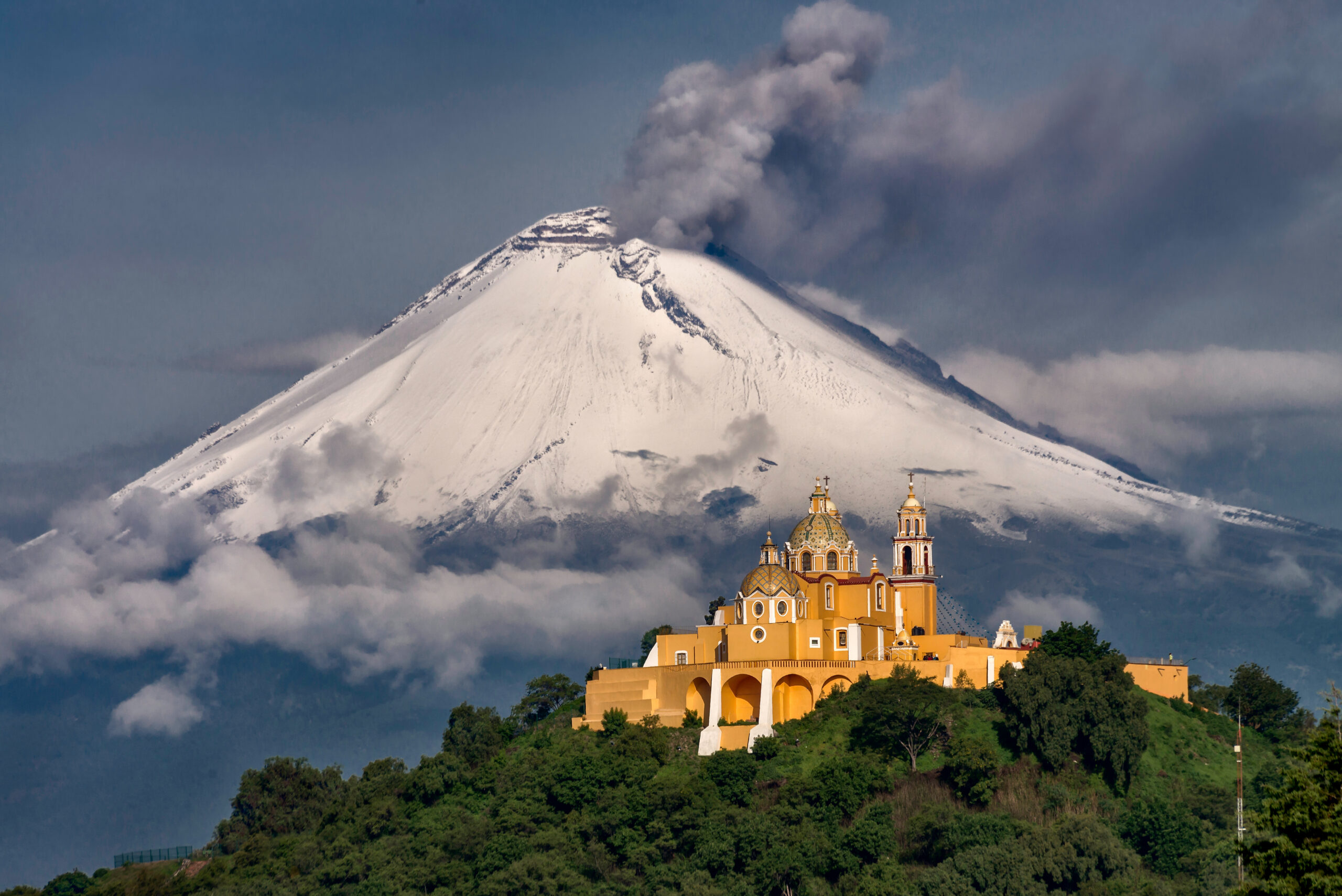
Popocatépetl (Closed to Climbing)
The second-highest peak in Mexico is currently closed to climbing due to ongoing volcanic activity. Popocatépetl (“Don Goyo” to locals) has been actively erupting since 1994 with regular ash emissions, occasional larger explosions, and sustained gas venting. CENAPRED, Mexico’s national emergency response center, maintains a 12-kilometer exclusion radius around the summit that explicitly prohibits climbing.
The closure has been in effect for over three decades and shows no signs of being lifted. Climbers who research “Popocatépetl climbing” historically should understand that this is a closed objective — the mountain was a popular climb in the 1970s and 1980s but has not been open for legal climbing since the eruption activity began. Mexican authorities take the closure seriously; climbers caught inside the exclusion zone face fines and removal.
Nevado de Toluca (Xinantécatl)
Nevado de Toluca is the fourth-highest peak in Mexico and one of the most accessible 4,000-meter volcanoes in the country. The volcano has a dramatic crater containing two lakes (Laguna del Sol and Laguna de la Luna) and a complete crater rim that can be walked in a long day. The road climbs to about 4,200 m, leaving only 480 m of vertical to the summit.
The peak is technically non-technical hiking but the high altitude and exposed crater rim require fitness and weather awareness. Most climbers use Nevado de Toluca as a one-day acclimatization peak before Iztaccíhuatl or Pico de Orizaba. The volcano sits west of Mexico City and is closer to Toluca city, making it easy to combine with cultural visits to the Toluca area.
La Malinche (Matlalcuéyetl)
La Malinche is the entry-level Mexican volcano and the standard first acclimatization peak for climbers preparing for the higher mountains. The volcano sits in the small state of Tlaxcala east of Mexico City and is climbed entirely as a day hike from the IMSS lodge at about 3,000 m. The standard route is a non-technical class 1-2 walk on a clear trail that takes 5-8 hours round trip.
Most climbers use La Malinche as the first peak in a multi-volcano progression — typically arriving in Mexico, doing 1-2 acclimatization nights in Mexico City, then climbing La Malinche on day 3-4 before moving to higher peaks. The mountain is also climbed extensively by Mexican hikers from the surrounding region as a weekend objective.
The natural progression sequence how to actually structure a Mexico trip
For climbers building toward Pico de Orizaba or just exploring Mexican mountaineering seriously, the typical progression spans 10-14 days and looks like this:
| Day | Peak / Activity | Elevation |
|---|---|---|
| 1-2 | Arrive Mexico City, acclimatization at 2,200-2,400 m | 2,200 m |
| 3-4 | La Malinche (acclimatization) | 4,461 m |
| 5 | Rest day in Cholula or Puebla | 2,100 m |
| 6-7 | Iztaccíhuatl (acclimatization + skills) | 5,230 m |
| 8-9 | Rest days in Tlachichuca or Mexico City | 2,400 m |
| 10-12 | Pico de Orizaba (summit attempt) | 5,636 m |
| 13-14 | Descent, return travel | Sea level |
This progression provides ideal altitude acclimatization for Orizaba and produces the highest summit success rates. Shorter trips (5-7 days) targeting Orizaba alone are possible but have meaningfully lower success rates because climbers arrive at the mountain inadequately acclimatized. Most experienced Mexico operators offer the full 10-14 day progression as their standard package.
Cost framework for Mexico mountaineering honest budgeting
Mexico is dramatically cheaper than equivalent peaks elsewhere in the Americas. The cost structure breaks down as follows:
| Trip type | Typical cost (USD) | What it includes |
|---|---|---|
| La Malinche day climb (self-guided) | $50-$150 | Park fee, transport, lodging |
| La Malinche guided | $150-$300 | Local guide, transport, lodging |
| Iztaccíhuatl 2-day guided | $300-$800 | Guide, lodge, summit attempt |
| Pico de Orizaba 3-5 day guided | $800-$2,500 | Guide, Piedra Grande hut, 4WD transport, summit attempt |
| Full progression (10-14 days, guided) | $2,500-$5,000 | All three peaks, lodging, transport, guides |
| International flights to Mexico City | $400-$1,500 | From US/Canada gateway cities |
| Personal mountaineering gear | $1,500-$3,000 | If buying new for Orizaba climb |
| Total full trip cost | $3,000-$7,500 | 10-14 day expedition including flights |
A full Mexican volcanoes expedition with three major peaks and English-speaking guide services costs roughly the same as Aconcagua’s permit fee alone. For climbers wanting high-altitude experience without expedition-tier budgets, Mexico is the answer.
When to climb Mexican volcanoes season by season
| Period | Conditions | Recommendation |
|---|---|---|
| November-December | Excellent — dry, stable, cool | Optimal early season |
| January | Best window — coldest, driest, most stable | Peak season for Orizaba |
| February | Excellent — late dry season | Optimal continuing window |
| March | Good — last reliable dry month | Excellent end of season |
| April | Transitional — increasing storms | Possible but riskier |
| May-October | Rainy season — afternoon storms daily | Avoid for major peaks |
The Mexican rainy season from May through October produces near-daily afternoon thunderstorms in the mountains. While early-morning climbing is sometimes possible, the conditions are dramatically less reliable than the dry season. Lower peaks (La Malinche, lower Iztaccíhuatl) are sometimes climbed in summer, but Pico de Orizaba’s Jamapa Glacier becomes hazardous due to soft snow and increased rockfall during the rainy months.
Logistics and access how to actually get there
Mexico City International Airport (MEX) is the standard arrival point, served by direct flights from most US gateway cities. Some climbers fly into Puebla International Airport (PBC) which is closer to the eastern volcanoes (Orizaba, La Malinche) but has fewer flight options.
| Hub city | Best for | Distance from peaks |
|---|---|---|
| Mexico City | All peaks, main gateway | 2-3 hours to Izta, 4-5 hours to Orizaba |
| Puebla | Orizaba, Malinche, Izta | 1.5-3 hours to all peaks |
| Tlachichuca | Orizaba (essential base) | 3-4 hours from base camp |
| Toluca | Nevado de Toluca | 1 hour to summit road |
Major operators
- Servimont Tlachichuca: the legendary Reyes family operation. Multi-generational guide service that has run Pico de Orizaba expeditions for decades. The original Pico Orizaba climbing base.
- Summit Climb Mexico: international operator running scheduled departures with English-speaking guides.
- Mountain Madness: US-based operator with established Mexican volcanoes programs.
- Alpenglow Expeditions: California-based operator with periodic Mexican volcanoes trips.
- Pico de Orizaba Tours: local Veracruz-based operator focused on the eastern approach.
Safety considerations honest assessment
- Altitude is the primary risk. Climbers move from Mexico City (2,400 m) to summits above 5,000 m within days. Proper acclimatization through the multi-peak progression is essential.
- Volcanic activity at Popocatépetl. While Popocatépetl is closed to climbing, its proximity to Iztaccíhuatl means climbers should monitor CENAPRED alerts. Ash deposition can affect Izta climbs during eruptive episodes.
- Glacier hazards on Pico de Orizaba. The Jamapa Glacier has crevasses and seasonal serac fall risk. Rope team travel is essential.
- Weather windows can collapse quickly. Pacific moisture can produce unexpected storms even during the dry season. Early starts and weather awareness matter.
- Driving safety in central Mexico. Standard precautions apply — daytime driving on main highways, avoid driving in rural areas after dark, use established operators for transport rather than self-driving rental cars to remote trailheads.
- Travel insurance: the framework for high-altitude trekking insurance is in our mountain climbing insurance decision framework.
Mexico vs the Andes honest comparison
| Dimension | Mexican volcanoes | Andean equivalents (Ecuador/Peru/Bolivia) |
|---|---|---|
| Highest peak | Pico de Orizaba 5,636 m | Chimborazo 6,263 m / Huascarán 6,768 m |
| Number of major peaks | 4 (climbable) | 15+ above 5,500 m |
| Access from North America | 3-5 hour flight | 8-12 hour flight + connections |
| Permit costs | Minimal ($5-$20) | Variable, often $100-$300 |
| Guide service cost | $500-$1,500 (Orizaba) | $1,500-$3,500 (Chimborazo) |
| Total expedition cost | $3,000-$7,500 | $4,000-$10,000 |
| Cultural environment | Mexico City, Puebla, Tlachichuca | Quito, Cusco, La Paz |
| Acclimatization for Aconcagua/Denali | Excellent foundation | Slightly better (higher peaks) |
| Technical climbing variety | Limited (mostly snow plods) | Wider variety, technical options |
Mexico wins on access, cost, and convenience. The Andes win on peak variety, technical options, and absolute altitude. For climbers prioritizing efficient progression and cost-effective acclimatization, Mexico is the right choice. For climbers wanting the deepest possible high-altitude experience or technical objectives, the Andes still hold the advantage.
Who should climb the Mexican volcanoes honest fit assessment
Mexico is excellent for you if…
- You’re a North American climber wanting high-altitude experience without long international travel
- You’re preparing for Aconcagua, Denali, or Himalayan trekking peaks and need acclimatization
- You want to graduate from US 14ers / Mount Rainier to international expeditions
- You appreciate cost-effective guided climbing without sacrificing safety
- You enjoy multi-peak progressions in a compact geographic area
- You’re interested in Mexican culture and want to combine climbing with cultural travel
Mexico might not fit if…
- You want technical climbing — Mexican volcanoes are mostly snow plods, not technical objectives
- You want extreme altitude (6,000+ m) — only Aconcagua, Andes, or Himalaya provide this
- You strongly prefer Spanish/cultural immersion in South America specifically
- You want the absolute highest peaks in the Americas — Aconcagua and Denali are higher
The complete Mexico mountaineering framework
Detailed peak profiles, route guides, costs, and the broader Trans-Mexican Volcanic Belt context.
Master collection →The bottom line on mountaineering in Mexico
Mountaineering in Mexico is one of the most underrated high-altitude climbing experiences in the Americas. The Trans-Mexican Volcanic Belt contains four climbable major volcanoes ranging from La Malinche at 4,461 m (entry-level day hike) to Pico de Orizaba at 5,636 m (the third-highest peak in North America requiring full mountaineering equipment). Popocatépetl at 5,426 m is closed due to ongoing volcanic activity. The country offers exceptional value compared to Andean alternatives: dramatically lower costs, easier access from North America, no major permit fees, and a compact peak cluster that allows efficient multi-peak progressions in 10-14 days. The natural sequence — La Malinche to Iztaccíhuatl to Pico de Orizaba — provides world-class acclimatization for climbers preparing for Aconcagua, Denali, or Himalayan trekking peaks. Best season is November through March, with December-February producing the most stable conditions for Orizaba’s Jamapa Glacier. For North American climbers building toward serious mountaineering, Mexico is the natural next step after Mount Rainier or Colorado 14ers. The full Mexico mountaineering framework is in our Mexico volcanoes master collection, with detailed Pico de Orizaba content in our Orizaba progression plan, routes guide, gear list, and difficulty assessment.
Frequently asked questions
What are the highest mountains in Mexico?
The highest mountains in Mexico are all stratovolcanoes located along the Trans-Mexican Volcanic Belt that crosses central Mexico east to west. Pico de Orizaba (Citlaltépetl) at 5,636 meters is the highest peak in Mexico and the third-highest in North America. Popocatépetl at 5,426 meters is the second-highest, but is closed to climbing due to active eruptions. Iztaccíhuatl at 5,230 meters is the third-highest and the most-climbed major volcano. Nevado de Toluca at 4,680 meters and La Malinche at 4,461 meters round out the major Mexican peaks for climbers.
Is mountaineering popular in Mexico?
Mountaineering in Mexico has a strong domestic following and an emerging international following. Mexican climbers have used the high volcanoes as training grounds for major expeditions for decades, and the country has produced notable mountaineers. International mountaineering tourism is smaller than in Peru or Ecuador but growing, driven primarily by climbers seeking high-altitude acclimatization for Aconcagua or Denali. The volcanoes are increasingly popular as cost-effective alternatives to Andean peaks of similar elevation, with lower permit costs and easier logistics for North American climbers.
How difficult are the Mexican volcanoes to climb?
The Mexican volcanoes range from easy hiking peaks to serious high-altitude mountaineering objectives. La Malinche at 4,461 meters is a non-technical day hike accessible to fit hikers. Nevado de Toluca at 4,680 meters is also non-technical but at higher altitude. Iztaccíhuatl at 5,230 meters involves moderate scrambling and route-finding plus high-altitude acclimatization. Pico de Orizaba at 5,636 meters requires full mountaineering equipment, glacier travel skills, and serious acclimatization – it is comparable in difficulty to a guided Aconcagua attempt or the standard Denali route in summer conditions. Popocatépetl is closed to climbing due to active volcanic activity.
What is the best time to climb Mexican volcanoes?
The best season for climbing Mexican volcanoes is from November through March, with December and January being the most stable months. This is the dry season in central Mexico, producing the most reliable weather and the most consistent snow conditions on the highest peaks. The rainy season from May through October produces frequent afternoon thunderstorms that make summit attempts risky. Pico de Orizaba in particular has its strongest conditions from December through February. April and October are shoulder seasons that can be excellent but unpredictable. Most international expeditions schedule trips for December through February for maximum success probability.
How much does it cost to climb in Mexico?
Mountaineering in Mexico is dramatically cheaper than equivalent peaks in the Andes or Alps. A typical Pico de Orizaba expedition costs 1,200 to 3,500 USD including local guide service, transport, and accommodation, plus international flights. Iztaccíhuatl trips cost 800 to 2,000 USD. Combination trips climbing multiple peaks (Malinche + Iztaccíhuatl + Orizaba over 10-14 days) cost 2,500 to 5,000 USD typically. International flights to Mexico City add 400 to 1,500 USD depending on origin. There are no significant permit fees for Mexican peaks – only basic park access fees of a few dollars per climber per day.
Do I need a guide to climb Mexican volcanoes?
You technically do not need a guide for most Mexican volcanoes, but most international climbers use one. La Malinche and Nevado de Toluca are commonly climbed without guides by experienced hikers. Iztaccíhuatl is often climbed self-guided by experienced mountaineers, though guides improve safety and success rate. Pico de Orizaba is almost universally climbed with a guide due to glacier travel requirements, altitude, and route-finding complexity on the Jamapa Glacier. Local Mexican guide services in Tlachichuca and Hidalgo offer excellent value at 500 to 1,500 USD for a 3-5 day Orizaba expedition – significantly less than equivalent guided services elsewhere.
Are Mexican volcanoes good for acclimatization?
Yes, the Mexican volcanoes are widely used as acclimatization for major Andean and Alaskan peaks. The progression from La Malinche (4,461m) to Nevado de Toluca (4,680m) to Iztaccíhuatl (5,230m) to Pico de Orizaba (5,636m) provides a structured altitude progression in a compact 10-14 day trip. Climbers preparing for Aconcagua, Denali, or Himalayan trekking peaks often use this Mexican volcanoes sequence as a final pre-expedition acclimatization. The combination of accessible altitude, cost-effective logistics, and the variety of peaks makes Mexico one of the best acclimatization regions in the Americas.
Mountaineering in Mexico’s High Volcanoes
Mexico’s big three volcanoes are a superb altitude ladder. Explore the peaks and the collection below.
Which Mexican Volcano Should You Climb First?
Mexico’s volcanoes work best as a progression, but not every climber needs the same sequence. Match the mountain to the skill you are trying to build: altitude tolerance, long summit days, basic snow travel or a full glacier objective.
La Malinche
Start here when the goal is to see how you move above 4,000 metres without adding glacier systems or a multi-day expedition. It is the cleanest first step in the classic progression.
Nevado de Toluca
Use Toluca when you want a high crater-rim day close to Mexico City. It is useful for altitude exposure, but it should not be mistaken for direct preparation for Orizaba’s glacier skills.
Iztaccíhuatl
Choose Izta when you are ready for a longer, colder summit day and want to build confidence above 5,000 metres before moving to Orizaba.
Pico de Orizaba
Choose Orizaba when you already have the fitness, altitude preparation and current snow/glacier skills required for the route conditions you will actually encounter.
Popocatépetl
Popocatépetl remains closed to climbing because of volcanic activity. Treat it as a hazard to monitor from nearby objectives, not an alternative summit.
Malinche → Izta → Orizaba
Use the three-mountain sequence when the goal is not simply to “bag” Orizaba, but to arrive with more altitude exposure, more recovery margin and better summit-day readiness.
| If your goal is… | Best starting point | What it builds | What it does not replace |
|---|---|---|---|
| Test altitude above 4,000 m | La Malinche | Pacing, cold management, altitude response | Snow/glacier skills |
| Add another high day near Mexico City | Nevado de Toluca | Altitude exposure, long crater-rim hiking | Rope-team travel |
| Break 5,000 m before Orizaba | Iztaccíhuatl | Long summit-day endurance, high-altitude judgment | Current Orizaba glacier technique |
| Build glacier-mountaineering experience | Pico de Orizaba | Cramponing, rope systems, high-altitude summit strategy | Prior acclimatization and skills training |
| Train for Aconcagua / Denali progression | Full three-peak sequence | Repeated altitude exposure + recovery cycles | Mountain-specific skills for the next expedition |
The sequence matters more than the number of peaks.
Do not compress the itinerary just to fit more summits. A climber who reaches Iztaccíhuatl well-acclimatized and arrives at Orizaba rested is better positioned than a climber who collects extra altitude days but carries fatigue into the main objective.
Verify the Park Rule That Applies to Each Volcano
Mexico’s high volcanoes do not use one unified permit system. Rules are park-specific and can change with volcanic activity, fire, snow, road conditions or visitor capacity.
Vehicle access can require a reservation.
CONANP’s current park listing says vehicle entry to La Joya requires advance reservation. It also currently lists a MXN 125 entrance fee and published opening hours that vary by day.
Climbing remains prohibited.
CONANP states that ascent has been prohibited since the 1994 eruptive period. CENAPRED’s September 18, 2026 monitoring report still lists Popocatépetl at Yellow Phase 2.
Confirm road and provider conditions before arrival.
CONANP advises visitors to contact the park for current guidance and registered tourism providers; rough mountain access roads require appropriate vehicles and conditions can change.
Mexico City → La Malinche → Iztaccíhuatl → Tlachichuca → Orizaba
The classic progression is compact by expedition standards, but not one trailhead. Mexico City is the gateway; Puebla/Cholula sit between objectives; Tlachichuca is the key Orizaba staging town.
Continue From the Regional Guide
Use the first row for the core Mexico volcano cluster. The second row contains exactly three Deep Recovery links chosen for altitude and Orizaba-specific readiness.
Was this helpful?
🏔Related peaks nearby
🧭Explore & compare
Global Summit Guide is an independent mountaineering resource founded in 2026. The team combines first-hand trekking and climbing experience with in-depth research and professional health and nutrition review to help climbers choose objectives, prepare properly, and stay safe.
Health, altitude, and nutrition content is reviewed by Taylor Ludlow (Registered Nurse) and Brigg Hoopes (Nutritionist).
What We Don't Know Yet
Mountain information changes quickly. This box explains the limits of what this page can responsibly promise.
- Weather, snowpack, avalanche risk, road access, and route conditions can change quickly and may be different on your climbing dates.
- Comparisons simplify complex decisions; the better mountain depends on current conditions, skills, timing, budget, and risk tolerance.
- Visa, passport, vaccination, border, insurance, and local transportation rules may change before your trip.
Verify current conditions with official land managers, guide services, local forecasts, and current route reports before booking or climbing.
Mountaineering, rock and ice climbing, glacier travel, and high-altitude activity are inherently dangerous and can result in serious injury or death. The information on Global Summit Guide is provided for general informational and educational purposes only and is not a substitute for professional instruction, qualified guiding, proper equipment, or your own judgment and experience.
Route conditions, weather, snowpack, permits, regulations, and hazards change constantly and may differ from what is described here. Details may be incomplete, out of date, or contain errors. Always verify current information with local authorities, certified guides, and official sources before making any decision in the mountains.
Nothing on this site is medical, legal, or financial advice. Our fitness, acclimatization, altitude, and nutrition content is general in nature; consult a qualified physician before beginning any strenuous exercise program or exposing yourself to high altitude.
You are solely responsible for your own safety and decisions. To the fullest extent permitted by law, Global Summit Guide and its team accept no liability for any loss, injury, damage, or expense arising from use of, or reliance on, this information. By using this site you acknowledge these risks and accept these terms.
Some links on this site may be affiliate links. If you buy through them we may earn a small commission at no extra cost to you; this never affects our recommendations.
Global Summit Guide recommendation path
Next Best Mountain to Research
Use these recommendations to continue the right planning path instead of stopping on one page.
Use current permit, weather, route, and operator information before booking or climbing.
Search Flights, Hotels & Rental Cars
Have the mountain or destination picked? Use Expedia to compare the flights, lodging and rental cars that fit your actual trip dates. For mountain travel, consider arriving early enough for delays and adding a buffer night after the climb before a fixed flight home.
Compare current flight, hotel and car options.
Affiliate disclosure: Global Summit Guide may earn a commission if you book through this link, at no additional cost to you.