web analytics

Tag: north america climbing

  • Mountaineering in Mexico: 4 High Volcanoes Compared

    Mountaineering in Mexico: A Climber’s Guide to the High Volcanoes of the Trans-Mexican Volcanic Belt | Global Summit Guide
    Regional Climbing Guides / Mexico

    Mountaineering in Mexico: a climber’s guide to the high volcanoes of the Trans-Mexican Volcanic Belt

    5,636 m
    Pico de Orizaba (highest)
    4 peaks
    Climbable major volcanoes
    $800-$3.5K
    Trip cost range
    Nov-Mar
    Best season
    ★ Part of the Mexico volcanoes series This regional guide supports our Mexico volcanoes master collection and connects all major Mexican peaks. Master guide →

    Mountaineering in Mexico is one of the most underrated high-altitude climbing experiences in the Americas. The country contains five major stratovolcanoes above 4,000 meters, with Pico de Orizaba at 5,636 m ranking as the third-highest peak in North America and the highest in Mexico. The volcanoes sit along the Trans-Mexican Volcanic Belt, all within a few hours’ drive of Mexico City — which makes Mexico one of the most logistically accessible high-altitude climbing destinations in the world. This guide covers the major peaks, when to climb them, costs, and the natural progression sequence that climbers actually use. For broader context see our Mexico volcanoes master collection.

    Why Mexico for mountaineering the underrated case

    Most international mountaineers headed for high-altitude experience in the Americas go directly to the Andes — Aconcagua, Cotopaxi, Huascarán, the Peruvian Cordillera Blanca. Mexico gets overlooked despite having mountains in the same elevation tier with several distinct advantages:

    • Direct access from major North American cities. Mexico City is a 3-5 hour flight from most US gateway cities. Compare this to 10-15 hours to Aconcagua’s gateway in Mendoza, Argentina.
    • No major permit costs. Mexican peaks have minimal park fees ($5-$20 per climber) compared to Aconcagua’s $800-$1,200 or Denali’s $400+ permits.
    • Compact peak cluster. The four climbable major peaks all sit within 2-3 hours of each other. Multi-peak trips are practical in 7-14 days.
    • Cost-effective guided climbing. Quality Mexican guide services charge $500-$1,500 for a 3-5 day Pico de Orizaba expedition — a fraction of equivalent guided trips in Argentina or Nepal.
    • Excellent acclimatization for harder peaks. The natural progression from La Malinche (4,461m) to Iztaccíhuatl (5,230m) to Pico de Orizaba (5,636m) provides world-class altitude preparation for Aconcagua, Denali, or Himalayan trekking peaks.
    • Dramatic volcanic terrain. The Trans-Mexican Volcanic Belt produces some of the most distinctive mountain scenery in the Americas — perfectly conical stratovolcanoes rising directly from agricultural plains.
    The use case that explains the Mexico volcanoes

    Mexico is where North American climbers go to graduate from intermediate to advanced. The progression from a Colorado 14er or Mount Rainier to Pico de Orizaba is the natural next step before Aconcagua or Denali. Mexican operators have built their entire industry around this progression — the climbing infrastructure is designed for North American mountaineers building skills, not for the casual hiker tourism that dominates Kilimanjaro or the trekking-focused industry of Nepal.

    The Trans-Mexican Volcanic Belt geography and geology

    Mexico’s high mountains are all volcanoes — specifically stratovolcanoes formed by the subduction of the Cocos Plate under the North American Plate along Mexico’s Pacific coast. The volcanoes are concentrated in a 900-kilometer east-west belt that crosses central Mexico from the Pacific Ocean near Puerto Vallarta to the Gulf of Mexico near Veracruz. This is the Trans-Mexican Volcanic Belt or Cordillera Neovolcánica — geologically distinct from the Sierra Madre ranges to the north and south.

    Geographic featureDetail
    Belt length~900 km east-west
    Highest pointPico de Orizaba (5,636 m)
    Number of major volcanoes5+ above 4,000 m
    Active eruptionsPopocatépetl (currently active)
    Tectonic originCocos Plate subduction
    Climbing access hubMexico City + Puebla + Tlachichuca
    Best seasonNovember – March (dry season)
    Climate typeTropical alpine

    The major climbable volcanoes peak by peak

    1

    Pico de Orizaba (Citlaltépetl)

    State: Puebla / Veracruz · Route: Jamapa Glacier (Normal) · Grade: PD · Duration: 3-5 days
    5,636 m

    The crown peak of Mexican mountaineering and the third-highest mountain in North America after Denali and Mount Logan. Pico de Orizaba is a perfect stratovolcano cone visible from much of central and eastern Mexico, with a permanent ice cap and the Jamapa Glacier on the upper mountain. The standard Normal Route via the Jamapa Glacier involves glacier travel with crampons and rope team, moderate elevation gain over 3-5 days, and requires full mountaineering equipment.

    Most climbers stage from Tlachichuca, the small town at the base of the mountain that has served as the climbing hub for over a century. From Tlachichuca, 4WD transport delivers climbers to the Piedra Grande hut at 4,260 m, with the summit attempt typically starting between midnight and 3 AM. The full Pico de Orizaba framework is in our Orizaba progression plan, with the route-specific detail in our Pico de Orizaba routes guide, gear list at Pico gear list, and difficulty assessment in our Pico difficulty and safety guide.

    2

    Iztaccíhuatl (Izta)

    State: México / Puebla · Route: Arista del Sol / La Joya · Grade: F+ / PD · Duration: 2-3 days
    5,230 m

    The “Sleeping Woman” volcano sits between Mexico City and Puebla, paired with the actively erupting Popocatépetl across a narrow valley. Iztaccíhuatl is a dormant volcano with five distinct summits along its long ridgeline, the highest being El Pecho (the chest). Unlike Pico de Orizaba, Iztaccíhuatl no longer has a true active glacier — climbers traverse rocky terrain and seasonal snow patches.

    The standard Arista del Sol route from La Joya trailhead involves moderate scrambling on volcanic rock and a long summit ridge traverse. Most climbers use the route as preparation for Pico de Orizaba, either climbing it directly before Orizaba for acclimatization or as a standalone introduction to 5,000-meter Mexican mountaineering. The route requires basic mountaineering skills but no technical climbing.

    ×

    Popocatépetl (Closed to Climbing)

    Status: Active eruption since 1994 · Currently: Climbing prohibited · Threat level: CENAPRED Yellow Phase 2
    5,426 m

    The second-highest peak in Mexico is currently closed to climbing due to ongoing volcanic activity. Popocatépetl (“Don Goyo” to locals) has been actively erupting since 1994 with regular ash emissions, occasional larger explosions, and sustained gas venting. CENAPRED, Mexico’s national emergency response center, maintains a 12-kilometer exclusion radius around the summit that explicitly prohibits climbing.

    The closure has been in effect for over three decades and shows no signs of being lifted. Climbers who research “Popocatépetl climbing” historically should understand that this is a closed objective — the mountain was a popular climb in the 1970s and 1980s but has not been open for legal climbing since the eruption activity began. Mexican authorities take the closure seriously; climbers caught inside the exclusion zone face fines and removal.

    3

    Nevado de Toluca (Xinantécatl)

    State: México · Route: Crater rim walk · Grade: F · Duration: Day hike
    4,680 m

    Nevado de Toluca is the fourth-highest peak in Mexico and one of the most accessible 4,000-meter volcanoes in the country. The volcano has a dramatic crater containing two lakes (Laguna del Sol and Laguna de la Luna) and a complete crater rim that can be walked in a long day. The road climbs to about 4,200 m, leaving only 480 m of vertical to the summit.

    The peak is technically non-technical hiking but the high altitude and exposed crater rim require fitness and weather awareness. Most climbers use Nevado de Toluca as a one-day acclimatization peak before Iztaccíhuatl or Pico de Orizaba. The volcano sits west of Mexico City and is closer to Toluca city, making it easy to combine with cultural visits to the Toluca area.

    4

    La Malinche (Matlalcuéyetl)

    State: Tlaxcala / Puebla · Route: Standard south slope · Grade: F · Duration: Day hike
    4,461 m

    La Malinche is the entry-level Mexican volcano and the standard first acclimatization peak for climbers preparing for the higher mountains. The volcano sits in the small state of Tlaxcala east of Mexico City and is climbed entirely as a day hike from the IMSS lodge at about 3,000 m. The standard route is a non-technical class 1-2 walk on a clear trail that takes 5-8 hours round trip.

    Most climbers use La Malinche as the first peak in a multi-volcano progression — typically arriving in Mexico, doing 1-2 acclimatization nights in Mexico City, then climbing La Malinche on day 3-4 before moving to higher peaks. The mountain is also climbed extensively by Mexican hikers from the surrounding region as a weekend objective.
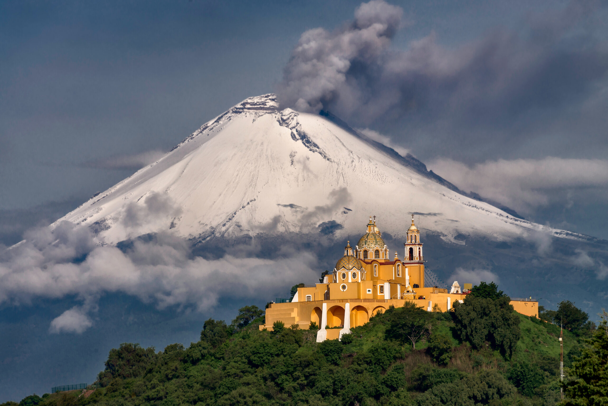
    The Mexican high volcanoes of the Trans-Mexican Volcanic Belt showing the dramatic stratovolcano peaks that climbers attempt during the November to March climbing season including Pico de Orizaba Iztaccíhuatl La Malinche and Nevado de Toluca
    The Trans-Mexican Volcanic Belt produces some of the most distinctive mountain scenery in North America — perfectly conical stratovolcanoes rising directly from the central Mexican plains.

    The natural progression sequence how to actually structure a Mexico trip

    For climbers building toward Pico de Orizaba or just exploring Mexican mountaineering seriously, the typical progression spans 10-14 days and looks like this:

    DayPeak / ActivityElevation
    1-2Arrive Mexico City, acclimatization at 2,200-2,400 m2,200 m
    3-4La Malinche (acclimatization)4,461 m
    5Rest day in Cholula or Puebla2,100 m
    6-7Iztaccíhuatl (acclimatization + skills)5,230 m
    8-9Rest days in Tlachichuca or Mexico City2,400 m
    10-12Pico de Orizaba (summit attempt)5,636 m
    13-14Descent, return travelSea level

    This progression provides ideal altitude acclimatization for Orizaba and produces the highest summit success rates. Shorter trips (5-7 days) targeting Orizaba alone are possible but have meaningfully lower success rates because climbers arrive at the mountain inadequately acclimatized. Most experienced Mexico operators offer the full 10-14 day progression as their standard package.

    Cost framework for Mexico mountaineering honest budgeting

    Mexico is dramatically cheaper than equivalent peaks elsewhere in the Americas. The cost structure breaks down as follows:

    Trip typeTypical cost (USD)What it includes
    La Malinche day climb (self-guided)$50-$150Park fee, transport, lodging
    La Malinche guided$150-$300Local guide, transport, lodging
    Iztaccíhuatl 2-day guided$300-$800Guide, lodge, summit attempt
    Pico de Orizaba 3-5 day guided$800-$2,500Guide, Piedra Grande hut, 4WD transport, summit attempt
    Full progression (10-14 days, guided)$2,500-$5,000All three peaks, lodging, transport, guides
    International flights to Mexico City$400-$1,500From US/Canada gateway cities
    Personal mountaineering gear$1,500-$3,000If buying new for Orizaba climb
    Total full trip cost$3,000-$7,50010-14 day expedition including flights
    The cost comparison that gets attention

    A full Mexican volcanoes expedition with three major peaks and English-speaking guide services costs roughly the same as Aconcagua’s permit fee alone. For climbers wanting high-altitude experience without expedition-tier budgets, Mexico is the answer.

    When to climb Mexican volcanoes season by season

    PeriodConditionsRecommendation
    November-DecemberExcellent — dry, stable, coolOptimal early season
    JanuaryBest window — coldest, driest, most stablePeak season for Orizaba
    FebruaryExcellent — late dry seasonOptimal continuing window
    MarchGood — last reliable dry monthExcellent end of season
    AprilTransitional — increasing stormsPossible but riskier
    May-OctoberRainy season — afternoon storms dailyAvoid for major peaks

    The Mexican rainy season from May through October produces near-daily afternoon thunderstorms in the mountains. While early-morning climbing is sometimes possible, the conditions are dramatically less reliable than the dry season. Lower peaks (La Malinche, lower Iztaccíhuatl) are sometimes climbed in summer, but Pico de Orizaba’s Jamapa Glacier becomes hazardous due to soft snow and increased rockfall during the rainy months.

    Logistics and access how to actually get there

    Mexico City International Airport (MEX) is the standard arrival point, served by direct flights from most US gateway cities. Some climbers fly into Puebla International Airport (PBC) which is closer to the eastern volcanoes (Orizaba, La Malinche) but has fewer flight options.

    Hub cityBest forDistance from peaks
    Mexico CityAll peaks, main gateway2-3 hours to Izta, 4-5 hours to Orizaba
    PueblaOrizaba, Malinche, Izta1.5-3 hours to all peaks
    TlachichucaOrizaba (essential base)3-4 hours from base camp
    TolucaNevado de Toluca1 hour to summit road

    Major operators

    • Servimont Tlachichuca: the legendary Reyes family operation. Multi-generational guide service that has run Pico de Orizaba expeditions for decades. The original Pico Orizaba climbing base.
    • Summit Climb Mexico: international operator running scheduled departures with English-speaking guides.
    • Mountain Madness: US-based operator with established Mexican volcanoes programs.
    • Alpenglow Expeditions: California-based operator with periodic Mexican volcanoes trips.
    • Pico de Orizaba Tours: local Veracruz-based operator focused on the eastern approach.

    Safety considerations honest assessment

    • Altitude is the primary risk. Climbers move from Mexico City (2,400 m) to summits above 5,000 m within days. Proper acclimatization through the multi-peak progression is essential.
    • Volcanic activity at Popocatépetl. While Popocatépetl is closed to climbing, its proximity to Iztaccíhuatl means climbers should monitor CENAPRED alerts. Ash deposition can affect Izta climbs during eruptive episodes.
    • Glacier hazards on Pico de Orizaba. The Jamapa Glacier has crevasses and seasonal serac fall risk. Rope team travel is essential.
    • Weather windows can collapse quickly. Pacific moisture can produce unexpected storms even during the dry season. Early starts and weather awareness matter.
    • Driving safety in central Mexico. Standard precautions apply — daytime driving on main highways, avoid driving in rural areas after dark, use established operators for transport rather than self-driving rental cars to remote trailheads.
    • Travel insurance: the framework for high-altitude trekking insurance is in our mountain climbing insurance decision framework.

    Mexico vs the Andes honest comparison

    DimensionMexican volcanoesAndean equivalents (Ecuador/Peru/Bolivia)
    Highest peakPico de Orizaba 5,636 mChimborazo 6,263 m / Huascarán 6,768 m
    Number of major peaks4 (climbable)15+ above 5,500 m
    Access from North America3-5 hour flight8-12 hour flight + connections
    Permit costsMinimal ($5-$20)Variable, often $100-$300
    Guide service cost$500-$1,500 (Orizaba)$1,500-$3,500 (Chimborazo)
    Total expedition cost$3,000-$7,500$4,000-$10,000
    Cultural environmentMexico City, Puebla, TlachichucaQuito, Cusco, La Paz
    Acclimatization for Aconcagua/DenaliExcellent foundationSlightly better (higher peaks)
    Technical climbing varietyLimited (mostly snow plods)Wider variety, technical options

    Mexico wins on access, cost, and convenience. The Andes win on peak variety, technical options, and absolute altitude. For climbers prioritizing efficient progression and cost-effective acclimatization, Mexico is the right choice. For climbers wanting the deepest possible high-altitude experience or technical objectives, the Andes still hold the advantage.

    Who should climb the Mexican volcanoes honest fit assessment

    Mexico is excellent for you if…

    • You’re a North American climber wanting high-altitude experience without long international travel
    • You’re preparing for Aconcagua, Denali, or Himalayan trekking peaks and need acclimatization
    • You want to graduate from US 14ers / Mount Rainier to international expeditions
    • You appreciate cost-effective guided climbing without sacrificing safety
    • You enjoy multi-peak progressions in a compact geographic area
    • You’re interested in Mexican culture and want to combine climbing with cultural travel

    Mexico might not fit if…

    • You want technical climbing — Mexican volcanoes are mostly snow plods, not technical objectives
    • You want extreme altitude (6,000+ m) — only Aconcagua, Andes, or Himalaya provide this
    • You strongly prefer Spanish/cultural immersion in South America specifically
    • You want the absolute highest peaks in the Americas — Aconcagua and Denali are higher
    ★ Mexico Volcanoes Master Resources

    The complete Mexico mountaineering framework

    Detailed peak profiles, route guides, costs, and the broader Trans-Mexican Volcanic Belt context.

    Master collection →

    The bottom line on mountaineering in Mexico

    Mountaineering in Mexico is one of the most underrated high-altitude climbing experiences in the Americas. The Trans-Mexican Volcanic Belt contains four climbable major volcanoes ranging from La Malinche at 4,461 m (entry-level day hike) to Pico de Orizaba at 5,636 m (the third-highest peak in North America requiring full mountaineering equipment). Popocatépetl at 5,426 m is closed due to ongoing volcanic activity. The country offers exceptional value compared to Andean alternatives: dramatically lower costs, easier access from North America, no major permit fees, and a compact peak cluster that allows efficient multi-peak progressions in 10-14 days. The natural sequence — La Malinche to Iztaccíhuatl to Pico de Orizaba — provides world-class acclimatization for climbers preparing for Aconcagua, Denali, or Himalayan trekking peaks. Best season is November through March, with December-February producing the most stable conditions for Orizaba’s Jamapa Glacier. For North American climbers building toward serious mountaineering, Mexico is the natural next step after Mount Rainier or Colorado 14ers. The full Mexico mountaineering framework is in our Mexico volcanoes master collection, with detailed Pico de Orizaba content in our Orizaba progression plan, routes guide, gear list, and difficulty assessment.

    Frequently asked questions

    What are the highest mountains in Mexico?

    The highest mountains in Mexico are all stratovolcanoes located along the Trans-Mexican Volcanic Belt that crosses central Mexico east to west. Pico de Orizaba (Citlaltépetl) at 5,636 meters is the highest peak in Mexico and the third-highest in North America. Popocatépetl at 5,426 meters is the second-highest, but is closed to climbing due to active eruptions. Iztaccíhuatl at 5,230 meters is the third-highest and the most-climbed major volcano. Nevado de Toluca at 4,680 meters and La Malinche at 4,461 meters round out the major Mexican peaks for climbers.

    Is mountaineering popular in Mexico?

    Mountaineering in Mexico has a strong domestic following and an emerging international following. Mexican climbers have used the high volcanoes as training grounds for major expeditions for decades, and the country has produced notable mountaineers. International mountaineering tourism is smaller than in Peru or Ecuador but growing, driven primarily by climbers seeking high-altitude acclimatization for Aconcagua or Denali. The volcanoes are increasingly popular as cost-effective alternatives to Andean peaks of similar elevation, with lower permit costs and easier logistics for North American climbers.

    How difficult are the Mexican volcanoes to climb?

    The Mexican volcanoes range from easy hiking peaks to serious high-altitude mountaineering objectives. La Malinche at 4,461 meters is a non-technical day hike accessible to fit hikers. Nevado de Toluca at 4,680 meters is also non-technical but at higher altitude. Iztaccíhuatl at 5,230 meters involves moderate scrambling and route-finding plus high-altitude acclimatization. Pico de Orizaba at 5,636 meters requires full mountaineering equipment, glacier travel skills, and serious acclimatization – it is comparable in difficulty to a guided Aconcagua attempt or the standard Denali route in summer conditions. Popocatépetl is closed to climbing due to active volcanic activity.

    What is the best time to climb Mexican volcanoes?

    The best season for climbing Mexican volcanoes is from November through March, with December and January being the most stable months. This is the dry season in central Mexico, producing the most reliable weather and the most consistent snow conditions on the highest peaks. The rainy season from May through October produces frequent afternoon thunderstorms that make summit attempts risky. Pico de Orizaba in particular has its strongest conditions from December through February. April and October are shoulder seasons that can be excellent but unpredictable. Most international expeditions schedule trips for December through February for maximum success probability.

    How much does it cost to climb in Mexico?

    Mountaineering in Mexico is dramatically cheaper than equivalent peaks in the Andes or Alps. A typical Pico de Orizaba expedition costs 1,200 to 3,500 USD including local guide service, transport, and accommodation, plus international flights. Iztaccíhuatl trips cost 800 to 2,000 USD. Combination trips climbing multiple peaks (Malinche + Iztaccíhuatl + Orizaba over 10-14 days) cost 2,500 to 5,000 USD typically. International flights to Mexico City add 400 to 1,500 USD depending on origin. There are no significant permit fees for Mexican peaks – only basic park access fees of a few dollars per climber per day.

    Do I need a guide to climb Mexican volcanoes?

    You technically do not need a guide for most Mexican volcanoes, but most international climbers use one. La Malinche and Nevado de Toluca are commonly climbed without guides by experienced hikers. Iztaccíhuatl is often climbed self-guided by experienced mountaineers, though guides improve safety and success rate. Pico de Orizaba is almost universally climbed with a guide due to glacier travel requirements, altitude, and route-finding complexity on the Jamapa Glacier. Local Mexican guide services in Tlachichuca and Hidalgo offer excellent value at 500 to 1,500 USD for a 3-5 day Orizaba expedition – significantly less than equivalent guided services elsewhere.

    Are Mexican volcanoes good for acclimatization?

    Yes, the Mexican volcanoes are widely used as acclimatization for major Andean and Alaskan peaks. The progression from La Malinche (4,461m) to Nevado de Toluca (4,680m) to Iztaccíhuatl (5,230m) to Pico de Orizaba (5,636m) provides a structured altitude progression in a compact 10-14 day trip. Climbers preparing for Aconcagua, Denali, or Himalayan trekking peaks often use this Mexican volcanoes sequence as a final pre-expedition acclimatization. The combination of accessible altitude, cost-effective logistics, and the variety of peaks makes Mexico one of the best acclimatization regions in the Americas.

    Choose by objective

    Which Mexican Volcano Should You Climb First?

    Mexico’s volcanoes work best as a progression, but not every climber needs the same sequence. Match the mountain to the skill you are trying to build: altitude tolerance, long summit days, basic snow travel or a full glacier objective.

    First altitude day

    La Malinche

    Start here when the goal is to see how you move above 4,000 metres without adding glacier systems or a multi-day expedition. It is the cleanest first step in the classic progression.

    Fast acclimatization peak

    Nevado de Toluca

    Use Toluca when you want a high crater-rim day close to Mexico City. It is useful for altitude exposure, but it should not be mistaken for direct preparation for Orizaba’s glacier skills.

    First 5,000-metre objective

    Iztaccíhuatl

    Choose Izta when you are ready for a longer, colder summit day and want to build confidence above 5,000 metres before moving to Orizaba.

    Main mountaineering objective

    Pico de Orizaba

    Choose Orizaba when you already have the fitness, altitude preparation and current snow/glacier skills required for the route conditions you will actually encounter.

    Do not climb

    Popocatépetl

    Popocatépetl remains closed to climbing because of volcanic activity. Treat it as a hazard to monitor from nearby objectives, not an alternative summit.

    Best complete sequence

    Malinche → Izta → Orizaba

    Use the three-mountain sequence when the goal is not simply to “bag” Orizaba, but to arrive with more altitude exposure, more recovery margin and better summit-day readiness.

    If your goal is…Best starting pointWhat it buildsWhat it does not replace
    Test altitude above 4,000 mLa MalinchePacing, cold management, altitude responseSnow/glacier skills
    Add another high day near Mexico CityNevado de TolucaAltitude exposure, long crater-rim hikingRope-team travel
    Break 5,000 m before OrizabaIztaccíhuatlLong summit-day endurance, high-altitude judgmentCurrent Orizaba glacier technique
    Build glacier-mountaineering experiencePico de OrizabaCramponing, rope systems, high-altitude summit strategyPrior acclimatization and skills training
    Train for Aconcagua / Denali progressionFull three-peak sequenceRepeated altitude exposure + recovery cyclesMountain-specific skills for the next expedition

    The sequence matters more than the number of peaks.

    Do not compress the itinerary just to fit more summits. A climber who reaches Iztaccíhuatl well-acclimatized and arrives at Orizaba rested is better positioned than a climber who collects extra altitude days but carries fatigue into the main objective.

    Current access checkpoints

    Verify the Park Rule That Applies to Each Volcano

    Mexico’s high volcanoes do not use one unified permit system. Rules are park-specific and can change with volcanic activity, fire, snow, road conditions or visitor capacity.

    Iztaccíhuatl · La Joya

    Vehicle access can require a reservation.

    CONANP’s current park listing says vehicle entry to La Joya requires advance reservation. It also currently lists a MXN 125 entrance fee and published opening hours that vary by day.

    Popocatépetl

    Climbing remains prohibited.

    CONANP states that ascent has been prohibited since the 1994 eruptive period. CENAPRED’s September 18, 2026 monitoring report still lists Popocatépetl at Yellow Phase 2.

    Pico de Orizaba

    Confirm road and provider conditions before arrival.

    CONANP advises visitors to contact the park for current guidance and registered tourism providers; rough mountain access roads require appropriate vehicles and conditions can change.

    Do not use a static blog fee as the final authority. Recheck CONANP, CENAPRED and the park/operator handling your exact route shortly before departure. Access procedures can change faster than a long-form climbing guide can be republished.
    Regional orientation

    Mexico City → La Malinche → Iztaccíhuatl → Tlachichuca → Orizaba

    The classic progression is compact by expedition standards, but not one trailhead. Mexico City is the gateway; Puebla/Cholula sit between objectives; Tlachichuca is the key Orizaba staging town.

    Orientation only—not a route-navigation map. Confirm current trailheads, road access, reservations and park closures before travel.

    Was this helpful?

    Yes
    No
    Thanks for your feedback!
  • Aconcagua vs Denali vs Rainier: Which Comes Next?

    @import url(‘https://fonts.googleapis.com/css2?family=DM+Serif+Display:ital@0;1&family=Outfit:wght@300;400;500;600;700;800&display=swap’); .gsg-adr80{ –navy:#071a2b;–navy2:#0d263d;–blue:#214f75;–gold:#d4913a;–gold2:#f0b45d; –cream:#f7f2e8;–paper:#fffdfa;–ink:#122a44;–muted:#657482;–line:#e4d7bd; –green:#315c49;–sea:#2f6f7d;–red:#934a3d; background:var(–paper);color:var(–ink); font:400 16px/1.66 ‘Outfit’,Arial,sans-serif;overflow:hidden } .gsg-adr80,.gsg-adr80 *{box-sizing:border-box} .gsg-adr80 a{color:var(–blue);text-decoration:none} .gsg-adr80 a:hover{color:var(–navy)} .gsg-adr80 img{display:block;width:100%;max-width:100%} .gsg-adr80 h1,.gsg-adr80 h2,.gsg-adr80 h3,.gsg-adr80 h4{ font-family:’DM Serif Display’,Georgia,serif;font-weight:400;line-height:1.08;margin:0 0 12px } .gsg-adr80 p{margin:0 0 14px} .gsg-adr80 ul{margin:10px 0 0;padding-left:20px} .gsg-adr80 li{margin:6px 0} .gsg-adr80-container{width:min(1120px,calc(100% – 44px));margin:auto} .gsg-adr80-section{padding:76px 0} .gsg-adr80-soft{background:linear-gradient(180deg,#fffdfa,#f8f6ef)} .gsg-adr80-band{background:var(–cream)} .gsg-adr80-dark{background:var(–navy);color:#fff} .gsg-adr80-kicker{ display:block;margin-bottom:8px;color:#98611c;font-size:.68rem; font-weight:800;letter-spacing:1.3px;text-transform:uppercase } .gsg-adr80-dark .gsg-adr80-kicker{color:var(–gold2)} .gsg-adr80-head{ display:grid;grid-template-columns:minmax(0,1.1fr) minmax(280px,.9fr); gap:34px;align-items:end;margin-bottom:28px } .gsg-adr80-head h2{color:var(–navy);font-size:clamp(2.2rem,4.1vw,3.8rem)} .gsg-adr80-head p{color:var(–muted);font-size:.94rem} .gsg-adr80-dark .gsg-adr80-head h2{color:#fff} .gsg-adr80-dark .gsg-adr80-head p{color:#cbd6de} .gsg-adr80-actions{display:flex;flex-wrap:wrap;gap:11px;margin-top:20px} .gsg-adr80-btn{ display:inline-flex;align-items:center;justify-content:center; min-height:45px;padding:12px 17px;border:1px solid transparent; border-radius:999px;font-size:.8rem;font-weight:800 } .gsg-adr80-btn.primary{background:var(–navy);color:#fff} .gsg-adr80-btn.secondary{background:#fff;color:var(–navy);border-color:#9cb0bd} .gsg-adr80-btn.gold{background:var(–gold);color:var(–navy)} /* HERO */ .gsg-adr80-hero{ position:relative;min-height:77svh;display:flex;align-items:center;overflow:hidden;background:#e5e8e9 } .gsg-adr80-hero>img{ position:absolute;inset:0;width:100%;height:100%;object-fit:cover;object-position:center 48% } .gsg-adr80-hero:after{ content:””;position:absolute;inset:0;z-index:1; background:linear-gradient(90deg, rgba(248,244,236,.995), rgba(248,244,236,.97) 42%, rgba(248,244,236,.73) 64%, rgba(248,244,236,.12) 89%, rgba(248,244,236,0)) } .gsg-adr80-hero-inner{ position:relative;z-index:2;width:min(1120px,calc(100% – 44px)); margin:auto;padding:76px 0 } .gsg-adr80-hero-copy{max-width:940px} .gsg-adr80-hero h1{ max-width:1000px;color:var(–navy);font-size:clamp(3.1rem,5.6vw,5.35rem) } .gsg-adr80-hero h1 em{color:#8c5a20;font-style:italic} .gsg-adr80-hero .lead{max-width:860px;color:#3e5667;font-size:1.06rem} .gsg-adr80-trust{display:flex;flex-wrap:wrap;gap:8px;margin-top:20px} .gsg-adr80-trust span{ padding:8px 10px;background:rgba(255,255,255,.88); border:1px solid #e5dbca;color:#516878;font-size:.72rem } /* ANSWER */ .gsg-adr80-answer{ position:relative;z-index:5;width:min(1120px,calc(100% – 44px)); margin:-42px auto 0;padding:28px;background:#fff; border:1px solid var(–line);border-top:5px solid var(–gold); box-shadow:0 12px 30px rgba(7,26,43,.08) } .gsg-adr80-answer-grid{display:grid;grid-template-columns:1.25fr .75fr;gap:28px} .gsg-adr80-answer h2{color:var(–navy);font-size:clamp(1.9rem,3vw,2.7rem)} .gsg-adr80-answer p{color:#40586a} .gsg-adr80-facts{display:grid;grid-template-columns:1fr 1fr;gap:8px} .gsg-adr80-fact{padding:15px;background:var(–navy);color:#fff} .gsg-adr80-fact b{ display:block;color:var(–gold2); font:400 1.5rem/1 ‘DM Serif Display’,Georgia,serif } .gsg-adr80-fact span{display:block;margin-top:5px;color:#cbd7df;font-size:.72rem} .gsg-adr80-jump{ display:grid;grid-template-columns:repeat(4,1fr);margin-top:20px;border:1px solid var(–line) } .gsg-adr80-jump a{ padding:12px 13px;border-right:1px solid var(–line);border-bottom:1px solid var(–line); color:var(–navy);font-size:.76rem;font-weight:800 } .gsg-adr80-jump a:hover{background:var(–cream)} /* COMMON */ .gsg-adr80-grid2{display:grid;grid-template-columns:repeat(2,1fr);gap:14px} .gsg-adr80-grid3{display:grid;grid-template-columns:repeat(3,1fr);gap:14px} .gsg-adr80-grid4{display:grid;grid-template-columns:repeat(4,1fr);gap:14px} .gsg-adr80-card{padding:22px;background:#fff;border:1px solid var(–line)} .gsg-adr80-card h3{color:var(–navy);font-size:1.46rem} .gsg-adr80-card p{color:var(–muted);font-size:.83rem} .gsg-adr80-card>span{ display:block;margin-bottom:8px;color:#98611c; font-size:.63rem;font-weight:800;letter-spacing:.9px;text-transform:uppercase } .gsg-adr80-callout{ margin-top:22px;padding:20px 22px;background:var(–cream);border-left:5px solid var(–gold) } .gsg-adr80-callout.green{background:#eff5f1;border-left-color:var(–green)} .gsg-adr80-callout.red{background:#faf1ef;border-left-color:var(–red)} /* TABLE */ .gsg-adr80-table{ margin-top:24px;overflow-x:auto;background:#fff;border:1px solid var(–line) } .gsg-adr80 table{width:100%;min-width:930px;border-collapse:collapse} .gsg-adr80 th,.gsg-adr80 td{ padding:13px 14px;text-align:left;vertical-align:top;border-bottom:1px solid var(–line) } .gsg-adr80 th{background:var(–navy);color:#fff;font-size:.76rem} .gsg-adr80 td{font-size:.84rem} .gsg-adr80 td strong{color:var(–navy)} .gsg-adr80-best{color:var(–green);font-weight:800} /* CHOOSE */ .gsg-adr80-choices{ display:grid;grid-template-columns:repeat(3,1fr);gap:14px } .gsg-adr80-choice{ position:relative;padding:25px;background:#fff;border:1px solid var(–line);border-top:5px solid var(–gold) } .gsg-adr80-choice small{ display:block;margin-bottom:7px;color:#98611c;font-size:.64rem; font-weight:800;text-transform:uppercase;letter-spacing:.8px } .gsg-adr80-choice h3{font-size:1.75rem;color:var(–navy)} .gsg-adr80-choice p{color:var(–muted);font-size:.83rem} /* PHOTO */ .gsg-adr80-photo{ position:relative;min-height:480px;display:flex;align-items:flex-end;overflow:hidden } .gsg-adr80-photo img{ position:absolute;inset:0;width:100%;height:100%;object-fit:cover } .gsg-adr80-photo:after{ content:””;position:absolute;inset:0; background:linear-gradient(0deg,rgba(7,26,43,.93),rgba(7,26,43,.05) 72%) } .gsg-adr80-photo-copy{ position:relative;z-index:2;width:min(1120px,calc(100% – 44px)); margin:auto;padding:46px 0 } .gsg-adr80-photo-panel{ max-width:870px;padding:25px;background:rgba(7,26,43,.84); border-left:5px solid var(–gold);color:#fff } .gsg-adr80-photo-panel h2{color:#fff;font-size:clamp(2rem,3.8vw,3.2rem)} .gsg-adr80-photo-panel p{color:#d6e2e9} /* GATES */ .gsg-adr80-gates{ display:grid;grid-template-columns:repeat(5,1fr);gap:8px;margin-top:24px } .gsg-adr80-gate{ padding:18px;background:#fff;border:1px solid var(–line) } .gsg-adr80-gate b{ display:flex;width:31px;height:31px;align-items:center;justify-content:center; margin-bottom:9px;border-radius:50%;background:var(–navy);color:var(–gold2);font-size:.72rem } .gsg-adr80-gate strong{display:block;color:var(–navy);font-size:.86rem} .gsg-adr80-gate span{display:block;margin-top:4px;color:var(–muted);font-size:.71rem} /* DARK */ .gsg-adr80-darkbox{padding:32px;background:var(–navy);color:#fff} .gsg-adr80-darkbox h2{color:#fff} .gsg-adr80-darkbox p{color:#cbd8df} .gsg-adr80-darkgrid{ display:grid;grid-template-columns:repeat(4,1fr);gap:9px;margin-top:20px } .gsg-adr80-darkgrid div{ padding:14px 12px;background:rgba(255,255,255,.04); border:1px solid rgba(255,255,255,.17) } .gsg-adr80-darkgrid b{display:block;margin-bottom:4px;color:var(–gold2);font-size:.75rem} .gsg-adr80-darkgrid span{display:block;color:#c7d4db;font-size:.7rem} /* MAPS */ .gsg-adr80-maps{ display:grid;grid-template-columns:repeat(3,1fr);gap:12px } .gsg-adr80-mapcard{background:#fff;border:1px solid var(–line)} .gsg-adr80-mapcard iframe{width:100%;height:280px;border:0} .gsg-adr80-mapcard div{padding:16px} .gsg-adr80-mapcard strong{display:block;color:var(–navy)} .gsg-adr80-mapcard span{display:block;margin-top:4px;color:var(–muted);font-size:.76rem} /* FAQ */ .gsg-adr80-faq{display:grid;gap:8px} .gsg-adr80 details{background:#fff;border:1px solid var(–line)} .gsg-adr80 summary{cursor:pointer;padding:17px 19px;color:var(–navy);font-weight:800} .gsg-adr80 details p{margin:0;padding:0 19px 18px;color:#40566b} /* LINKS */ .gsg-adr80-links{display:grid;grid-template-columns:repeat(3,1fr);gap:14px} .gsg-adr80-link{display:block;padding:21px;background:#fff;border:1px solid var(–line)} .gsg-adr80-link:hover{border-color:var(–gold)} .gsg-adr80-link small{ display:block;color:#98611c;font-size:.64rem;font-weight:800; text-transform:uppercase;letter-spacing:.8px } .gsg-adr80-link strong{display:block;margin:5px 0;color:var(–navy)} .gsg-adr80-link span{display:block;color:var(–muted);font-size:.78rem} /* SOURCES */ .gsg-adr80-sources{ padding:25px;background:#fff;border:1px solid var(–line);border-top:5px solid var(–gold) } .gsg-adr80-sources p,.gsg-adr80-sources li{color:var(–muted);font-size:.82rem} /* FINAL */ .gsg-adr80-final{padding:62px 0;background:var(–navy);color:#fff;text-align:center} .gsg-adr80-final h2{color:#fff;font-size:clamp(2.2rem,4.5vw,4rem)} .gsg-adr80-final p{max-width:830px;margin:0 auto;color:#d6e2e9} @media(max-width:1050px){ .gsg-adr80-grid4,.gsg-adr80-darkgrid{grid-template-columns:repeat(2,1fr)} .gsg-adr80-gates{grid-template-columns:repeat(3,1fr)} } @media(max-width:900px){ .gsg-adr80-head,.gsg-adr80-answer-grid{grid-template-columns:1fr} .gsg-adr80-grid3,.gsg-adr80-links,.gsg-adr80-choices,.gsg-adr80-maps{grid-template-columns:1fr} } @media(max-width:650px){ .gsg-adr80-container,.gsg-adr80-hero-inner,.gsg-adr80-answer,.gsg-adr80-photo-copy{ width:min(100% – 28px,1120px) } .gsg-adr80-section{padding:52px 0} .gsg-adr80-hero{min-height:83svh;align-items:flex-end} .gsg-adr80-hero-inner{padding:56px 0 86px} .gsg-adr80-hero h1{font-size:clamp(2.55rem,11vw,4rem)} .gsg-adr80-answer{margin-top:-36px} .gsg-adr80-facts,.gsg-adr80-grid2,.gsg-adr80-grid4,.gsg-adr80-darkgrid,.gsg-adr80-gates{grid-template-columns:1fr} .gsg-adr80-jump{grid-template-columns:1fr 1fr} }
    Mount Rainier and its glaciers in Washington
    Mountain Progression · Rainier · Aconcagua · Denali

    Aconcagua vs Denali vs Rainier: Which Mountain Should Come Next?

    These three mountains should not be treated as a fixed checklist. Rainier tests glacier and rope-team foundations. Aconcagua tests prolonged high-altitude performance. Denali combines glacier systems, expedition cold, heavy loads and weeks of self-supported mountain living. The right next peak is the one that exposes the capability you still need to prove.

    Rainier · 4,392 m Denali · 6,190 m Aconcagua · 6,962.8 m capability-based progression 2026 fees verified where available
    The direct answer

    Which Should You Climb First: Rainier, Aconcagua or Denali?

    If you have not yet built real glacier and rope-team competence, Rainier or an equivalent glaciated training mountain belongs early. It compresses glacier travel, crampon movement, rope-team systems, crevasse awareness and a serious summit day into a short objective.

    After that, the choice between Aconcagua and Denali should be driven by the capability you need next. Choose Aconcagua when prolonged extreme altitude is the missing test. Choose Denali when glacier self-sufficiency, heavy loads, snow camping and severe cold are the missing systems.

    There is no mandatory three-mountain order. Rainier → Aconcagua → Denali is logical for many climbers, but Rainier → Denali → Aconcagua can also make sense, and experienced climbers may arrive with equivalent skills from entirely different peaks.
    Rainier Glacier foundation
    Aconcagua Extreme-altitude test
    Denali Expedition-system test
    No fixed order Readiness gaps determine sequence
    The comparison that matters

    Rainier vs Aconcagua vs Denali.

    Elevation alone gives the wrong order. Each mountain tests a different mix of skills and expedition systems.

    FactorMount RainierAconcaguaDenali
    Elevation4,392 m / 14,410 ft6,962.8 m / 22,845 ft6,190 m / 20,310 ft
    Standard objectiveDisappointment Cleaver / Ingraham corridorNormal Route via HorconesWest Buttress
    Typical trip3–5 days on common guided programs18–21 days17–21 days typical expedition
    Glacier travelCore skillNot central on the Normal RouteCore skill for weeks
    Rope-team systemsCentralLimited on Normal RouteCentral from the Kahiltna onward
    Primary altitude testModerate-high altitudeExtreme altitude near 7,000 mVery high altitude + high-latitude physiology
    Load haulingLoaded packExpedition carries above base campHeavy pack + sled system
    Cold exposureSerious but relatively shortCold + severe windSustained expedition cold
    Camp systemsShort-duration high campMulti-week expedition campsSnow camps + cache system + storm management
    2026 official fee$82 climbing fee2026–27 tariff should be rechecked before booking$450 mountaineering fee + $15 park entrance unless covered
    Best roleGlacier foundationAltitude expeditionFull expedition-systems test
    Do not compare summit-success percentages casually. Rainier, Denali and Aconcagua reporting uses different populations, years and definitions. Use the dedicated success-rate pages rather than putting three incompatible headline percentages in one table.
    Mount Rainier above Washington's Cascade landscape
    Foundation mountain

    Rainier Is Valuable Because It Makes Glacier Skills Real.

    Rainier is not merely a smaller version of Denali. Its value in a progression is that it exposes climbers to roped glacier travel, crevasse terrain, crampon movement, loaded ascent and a consequential descent without requiring a three-week Alaska expedition.

    Choose by missing capability

    Which Mountain Should You Climb Next?

    Start with what your résumé does not yet prove.

    You need glacier competence

    Choose Rainier

    Best when your background is strong hiking and altitude but weak in crampons, rope-team travel, crevasse awareness and glaciated summit movement.

    • Learn real rope-team movement.
    • Test crampon efficiency under fatigue.
    • Experience a pre-dawn glacier summit day.
    • Use the result to identify whether Baker or another glacier climb is still needed.
    You need an altitude test

    Choose Aconcagua

    Best when your technical systems are adequate but you still lack proof that you can acclimatize, recover and keep functioning near 7,000 meters.

    • Long acclimatization cycle.
    • Multiple high camps.
    • Wind and cold without major technical climbing.
    • Strong preparation for higher nontechnical expedition peaks.
    You need expedition systems

    Choose Denali

    Best when glacier skills and altitude experience are already strong, but you have not yet proved heavy-load hauling, snow-camp systems, self-sufficiency and decision-making through a multi-week cold expedition.

    • Pack + sled hauling.
    • Cache strategy.
    • Glacier travel every day.
    • Storm-resistant camp management.
    Mount Rainier · 4,392 m

    Rainier: Prove the Glacier Foundation.

    Rainier belongs early when glacier systems are the gap, but the mountain name itself is not mandatory.

    What it teaches

    Glacier Movement

    Rope-team discipline, crevasse awareness, crampons, ice-axe use and sustained travel on active glacier terrain.

    What it tests

    Mountain Endurance

    More than 9,000 vertical feet from Paradise to the summit, plus a descent that must be completed while tired.

    What it does not prove

    Multi-Week Expedition Living

    Rainier cannot by itself demonstrate that a climber can function for three weeks while hauling heavy loads in severe cold.

    Equivalent experience counts. A climber who already has strong glacier experience on Baker, the Canadian Rockies, the Alps or similar terrain does not need Rainier simply to collect the mountain name.
    Aconcagua above the Andes in Mendoza, Argentina
    Altitude without major technical climbing

    Aconcagua Separates High-Altitude Ability From Glacier Technique.

    On the Normal Route, the central question is not whether you can climb difficult ice or rock. It is whether you can acclimatize, carry, recover, eat, sleep and make good decisions while approaching 7,000 meters.

    Aconcagua · 6,962.8 m

    Aconcagua: Prove Extreme-Altitude Endurance.

    Aconcagua is not “just altitude,” but altitude is the defining progression value of its Normal Route.

    What it teaches

    Long Acclimatization

    Multiple weeks of gradual ascent, carries, rest, recovery and repeated performance at high elevation.

    What it tests

    Nearly 7,000 m

    Aconcagua exposes weaknesses in appetite, sleep, pace, recovery and altitude tolerance that lower peaks may never reveal.

    What it does not replace

    Glacier & Rescue Skills

    A successful Normal Route expedition does not prove Denali-level rope-team travel, crevasse rescue or snow-camp competence.

    Do not use last season’s permit price as the next season’s price. The 2025–26 advance-sale international ascent rates were published separately by route. Recheck Mendoza’s official 2026–27 schedule before booking.
    Denali rising above the Alaska Range
    The systems mountain

    Denali Is Where All the Capabilities Start Stacking Together.

    Glacier travel is only the beginning. Climbers must also haul weeks of food and fuel, manage caches, maintain snow camps, tolerate severe cold, climb fixed lines while loaded and preserve enough energy for the descent.

    Denali · 6,190 m

    Denali: Prove the Entire Expedition System.

    A climber should not arrive on the Kahiltna expecting Denali to teach glacier rescue, snow camping or heavy-load expedition systems from scratch.

    Glacier

    Roped From the Beginning

    The West Buttress begins on the Kahiltna Glacier and remains a glacier expedition rather than a trekking approach.

    Load

    Pack + Sled

    Climbers repeatedly move food, fuel and group equipment, making load management one of the defining progression differences.

    Cold

    Weeks, Not Hours

    The challenge is not one cold summit morning. It is keeping boots, hands, sleep systems, fuel and judgment working through sustained Alaska Range conditions.

    2026 NPS reference: the adult mountaineering fee is $450 plus the $15 park entrance fee unless covered by an eligible pass. Normal registration must begin at least 60 days before the requested start date.
    Readiness before résumé

    Five Gates Matter More Than Which Mountain Name Comes First.

    A useful progression closes capability gaps. Before moving toward Denali—or toward higher expedition climbing— make sure each gate has been demonstrated rather than merely discussed.

    1 · Endurance Repeated long mountain days with meaningful pack weight.
    2 · Glacier systems Rope-team travel, crevasse rescue and competent crampon movement.
    3 · Altitude Evidence that you can acclimatize, eat, sleep and recover high.
    4 · Cold & camp systems Reliable sleep, moisture, stove, boot and glove systems.
    5 · Expedition judgment Conservative decisions after days or weeks of accumulated fatigue.
    Not a gate Owning the gear without practicing the systems.
    Not a gate One guided summit where the guide performed every technical task.
    Not a gate A fixed list of mountain names completed in a prescribed order.
    Three valid progressions

    There Is More Than One Good Sequence.

    The right path depends on what you already know and what your next objective demands.

    Sequence A

    Rainier → Aconcagua → Denali

    Strong for a climber who first needs glacier foundations, then wants to prove extreme altitude before adding the full cold-and-load complexity of Alaska.

    Sequence B

    Rainier → Denali → Aconcagua

    Logical for a climber whose glacier systems are strong, who wants Alaska expedition competence early, and who will later use Aconcagua as the higher-altitude test.

    Sequence C

    Equivalent Skills → Aconcagua or Denali

    An experienced alpinist may already have Rainier-equivalent glacier competence from Baker, the Alps, Canadian Rockies, Alaska or another appropriate training history.

    The weakest sequence is the one chosen for prestige instead of readiness. A harder mountain is not automatically the correct next mountain.
    Denali and the Alaska Range
    Before Denali

    The Best Denali Preparation Is a Capability Stack, Not One Famous Summit.

    Glacier skill from Rainier or Baker, altitude experience from Aconcagua or another high peak, winter-camp systems and serious load training can come from different mountains. Denali only cares whether they work.

    Current permit comparison

    Do Not Build the Decision Around Old Fee Tables.

    Fees change. Use current official sources close to booking.

    MountainCurrent verified referenceRegistration notePlanning implication
    Mount Rainier$82 per climber per climb in 2026Pay before registration; camp/wilderness reservation process is separate.Low administrative cost relative to the other two.
    Denali$450 adult 2026 mountaineering fee + $15 entrance fee unless coveredNormal registration at least 60 days in advance.Permit timing must be resolved early.
    Aconcagua2026–27 final tariff should be reverifiedGovernment permit varies by route, season and traveler category.Do not carry forward the prior season’s number as though it were current.
    Season strategy

    The Calendar Can Help Separate the Progression.

    The three mountains do not compete for exactly the same season, which makes it possible to space them intelligently.

    Rainier

    Late Spring–Summer

    The standard climbing season runs through the warmer Cascades months, with route conditions changing substantially as summer progresses.

    Denali

    Late April–Mid July

    The West Buttress season is compressed by Alaska weather, glacier travel conditions and the NPS expedition calendar.

    Aconcagua

    Austral Summer

    December through February forms the core expedition window, allowing Aconcagua to fit between Northern Hemisphere mountain seasons.

    Approach terrain below Aconcagua in Argentina
    Different mountains, different lessons

    Aconcagua Does Not Replace Rainier—and Rainier Does Not Replace Aconcagua.

    One builds technical glacier familiarity at moderate altitude. The other reveals what happens to your body and expedition rhythm when the summit approaches 7,000 meters. A useful progression needs both capabilities, wherever you acquire them.

    Geographic orientation

    Three Mountains Across Two Hemispheres.

    Their locations explain much of the progression: maritime Cascade weather, high-latitude Alaska expedition conditions, and the dry high Andes each create a different mountain system.

    Mount Rainier · Washington Cascade glacier mountain south of Seattle and Tacoma.
    Denali · Alaska Remote Alaska Range expedition accessed through Talkeetna and the Kahiltna Glacier.
    Aconcagua · Argentina High Andes expedition west of Mendoza near the Chilean border.
    Direct search answers

    Aconcagua vs Denali vs Rainier FAQ.

    Progression should answer readiness questions rather than create arbitrary prerequisites.

    Should I climb Rainier before Denali?

    Climbers who do not already possess equivalent glacier experience should build Rainier-level competence before Denali. Rainier is one strong way to learn and demonstrate rope-team movement, crampons, glacier travel and crevasse systems, but equivalent experience on other suitable mountains can fulfill the same role.

    Should I climb Aconcagua or Denali first?

    Choose Aconcagua first when extreme altitude is the main capability you still need to test. Choose Denali first only when your glacier systems, cold-weather camping, load hauling and prior altitude experience are already strong.

    Is Denali harder than Aconcagua?

    Denali generally demands a broader expedition skill set because it combines glacier travel, heavy pack-and-sled hauling, snow camps, cold, altitude and more self-sufficient logistics. Aconcagua is higher and can be the more difficult physiological test for climbers who struggle with extreme altitude.

    Is Aconcagua more technical than Rainier?

    Not on Aconcagua’s standard Normal Route. Rainier requires substantially more glacier and rope-team competence, while Aconcagua’s Normal Route places much greater emphasis on altitude, endurance, wind and multi-week expedition performance.

    Can I go directly from Rainier to Denali?

    Some climbers can, but a Rainier summit alone is not proof of Denali readiness. You should also be competent in crevasse rescue, glacier rope systems, cold-weather camping, heavy-load movement and multi-day expedition living.

    Can I go directly from Rainier to Aconcagua?

    Yes, that can be a logical progression when the climber already has strong endurance and wants to add a major altitude expedition next. Additional experience above 5,000 meters can improve the preparation picture.

    Which mountain is highest?

    Aconcagua is highest at about 6,962.8 meters, followed by Denali at 6,190 meters and Mount Rainier at 4,392 meters.

    Which mountain is best preparation for the Himalaya?

    The strongest preparation uses the capabilities from all three categories: Rainier-style glacier competence, Aconcagua-style altitude exposure and Denali-style expedition systems. None of the three alone constitutes complete preparation for an 8,000-meter expedition.

    What is a sensible progression through all three?

    Rainier or equivalent glacier experience can come first, followed by Aconcagua and Denali in either order depending on whether altitude or expedition systems are the larger remaining gap.

    Current verification

    Use Current Rules, Not a Static Comparison Table.

    Last researched: September 21, 2026. Rainier and Denali 2026 NPS fees are verified. Recheck Aconcagua’s official 2026–27 summer tariff before publishing a next-season permit number.

    The progression decision

    Do Not Ask Which Mountain Is Next. Ask Which Capability Is Missing.

    Use Rainier or equivalent terrain to prove glacier competence. Use Aconcagua to prove prolonged high-altitude function. Use Denali when glacier systems, cold-weather camps, heavy loads and expedition self-sufficiency are already skills—not things you hope to learn after landing on the Kahiltna.

    { “@context”:”https://schema.org”, “@type”:”FAQPage”, “mainEntity”:[ { “@type”:”Question”, “name”:”Should I climb Rainier before Denali?”, “acceptedAnswer”:{ “@type”:”Answer”, “text”:”Climbers who do not already possess equivalent glacier experience should build Rainier-level competence before Denali. Rainier is one strong way to learn and demonstrate rope-team movement, crampons, glacier travel and crevasse systems, but equivalent experience on other suitable mountains can fulfill the same role.” } }, { “@type”:”Question”, “name”:”Should I climb Aconcagua or Denali first?”, “acceptedAnswer”:{ “@type”:”Answer”, “text”:”Choose Aconcagua first when extreme altitude is the main capability you still need to test. Choose Denali first only when glacier systems, cold-weather camping, load hauling and prior altitude experience are already strong.” } }, { “@type”:”Question”, “name”:”Is Denali harder than Aconcagua?”, “acceptedAnswer”:{ “@type”:”Answer”, “text”:”Denali generally demands a broader expedition skill set because it combines glacier travel, heavy pack-and-sled hauling, snow camps, cold, altitude and more self-sufficient logistics. Aconcagua is higher and can be the more difficult physiological test for climbers who struggle with extreme altitude.” } }, { “@type”:”Question”, “name”:”Is Aconcagua more technical than Rainier?”, “acceptedAnswer”:{ “@type”:”Answer”, “text”:”Not on Aconcagua’s standard Normal Route. Rainier requires substantially more glacier and rope-team competence, while Aconcagua’s Normal Route places more emphasis on altitude, endurance, wind and multi-week expedition performance.” } }, { “@type”:”Question”, “name”:”Can I go directly from Rainier to Denali?”, “acceptedAnswer”:{ “@type”:”Answer”, “text”:”Some climbers can, but a Rainier summit alone is not proof of Denali readiness. Climbers should also be competent in crevasse rescue, glacier rope systems, cold-weather camping, heavy-load movement and multi-day expedition living.” } }, { “@type”:”Question”, “name”:”Can I go directly from Rainier to Aconcagua?”, “acceptedAnswer”:{ “@type”:”Answer”, “text”:”Yes, that can be a logical progression when the climber already has strong endurance and wants to add a major altitude expedition next. Additional experience above 5,000 meters can strengthen the preparation.” } }, { “@type”:”Question”, “name”:”Which mountain is highest: Rainier, Denali or Aconcagua?”, “acceptedAnswer”:{ “@type”:”Answer”, “text”:”Aconcagua is highest at about 6,962.8 meters, followed by Denali at 6,190 meters and Mount Rainier at 4,392 meters.” } }, { “@type”:”Question”, “name”:”Which mountain is best preparation for the Himalaya?”, “acceptedAnswer”:{ “@type”:”Answer”, “text”:”The strongest preparation combines Rainier-style glacier competence, Aconcagua-style altitude exposure and Denali-style expedition systems. None of the three alone is complete preparation for an 8,000-meter expedition.” } }, { “@type”:”Question”, “name”:”What is a sensible progression through Rainier, Aconcagua and Denali?”, “acceptedAnswer”:{ “@type”:”Answer”, “text”:”Rainier or equivalent glacier experience can come first, followed by Aconcagua and Denali in either order depending on whether altitude or expedition systems are the larger remaining capability gap.” } } ] }
    .gsg-drmesh{–navy:#071a2b;–blue:#214f75;–gold:#d4913a;–cream:#f7f2e8;–paper:#fffdfa;–ink:#122a44;–muted:#657482;–line:#e4d7bd;font:400 16px/1.6 ‘Outfit’,Arial,sans-serif;color:var(–ink);background:var(–paper)} .gsg-drmesh *{box-sizing:border-box} .gsg-drmesh h2{font-family:’DM Serif Display’,Georgia,serif;font-weight:400;color:var(–navy);font-size:clamp(1.6rem,3vw,2.2rem);line-height:1.1;margin:0 0 8px} .gsg-drmesh p{margin:0 0 16px;color:#526a7a;font-size:.92rem} .gsg-drmesh a{text-decoration:none;color:var(–blue)} .gsg-drmesh-wrap{width:min(1000px,calc(100% – 28px));margin:0 auto;padding:26px 0;border-top:3px solid var(–gold)} .gsg-drmesh-k{display:block;color:#98611c;font-size:.7rem;font-weight:800;letter-spacing:1.1px;text-transform:uppercase;margin-bottom:8px} .gsg-drmesh-up{display:flex;flex-wrap:wrap;gap:10px;margin-bottom:16px} .gsg-drmesh-up a{flex:1 1 240px;background:var(–navy);color:#fff;padding:13px 16px;font-weight:700;font-size:.86rem;display:flex;align-items:center;justify-content:space-between} .gsg-drmesh-up a.hub{background:#fff;color:var(–navy)!important;border:1px solid var(–line)} .gsg-drmesh-up a b{font-family:’DM Serif Display’,serif;font-weight:400} .gsg-drmesh-grid{display:grid;grid-template-columns:repeat(3,1fr);gap:9px} .gsg-drmesh-grid a{background:var(–cream);border:1px solid var(–line);padding:12px 13px;display:block} .gsg-drmesh-grid a strong{display:block;color:var(–navy);font-size:.92rem} .gsg-drmesh-grid a span{display:block;color:var(–muted);font-size:.72rem;margin-top:2px} .gsg-drmesh-grid a:hover{border-color:var(–gold)} @media(max-width:700px){.gsg-drmesh-grid{grid-template-columns:1fr 1fr}} @media(max-width:460px){.gsg-drmesh-grid{grid-template-columns:1fr}}
    Progression · The big-mountain ladder

    Aconcagua, Denali, Rainier: The Progression Compared

    These three define the classic big-mountain ladder. See the related comparisons and the progression hub below.

    Was this helpful?

    Yes
    No
    Thanks for your feedback!
Language »