
Last updated June 1, 2026
Machapuchare: The Holy Mountain Nepal Will Not Let You Climb
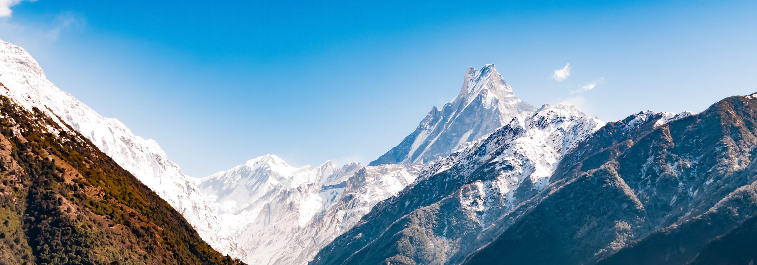
Machapuchare — the Fishtail, the Matterhorn of Nepal — rises 6,993m above the Pokhara Valley as the eastern gatepost of the Annapurna Sanctuary. It is one of the most photographed mountains on Earth and one of the very few major Himalayan peaks that has never been officially summited. Sacred to the Gurung people and revered as a home of Shiva, it has been closed to climbing since the single attempt of 1957, when Wilfrid Noyce and David Cox stopped roughly 46 metres below the top and turned back. This is the story of that forbidden summit — and how to see it for yourself.
The Story of Machapuchare
Machapuchare — Machhapuchhre in Nepali, from machha (“fish”) and puchhre (“tail”) — takes its name from a distinctive double summit that, seen from the Pokhara Valley, resembles the tail of a fish. From other angles the twin peaks merge into a single, impossibly sharp spire, which earned it a second nickname: the Matterhorn of Nepal. At 6,993 metres it is far from the tallest peak in the Annapurna Himal, but its steep, soaring profile and its place on the southern rim of the Annapurna Sanctuary make it one of the most recognisable mountains on Earth.
The mountain rises directly above Pokhara, about 25 kilometres to the southeast, and stands opposite Hiunchuli at the mouth of the Modi Khola gorge — together the two peaks form the natural gateway into the Sanctuary that surrounds Annapurna Base Camp. Every trekker who walks into that amphitheatre passes in Machapuchare’s shadow.
A Sacred Peak, the Home of Shiva
Machapuchare is sacred to the Gurung people and the community of Chomrong, and is widely revered as a home of the Hindu god Shiva. In local belief the plume of spindrift that so often streams from its summit is read as the smoke of Shiva’s incense. That religious significance is not a footnote to the mountain’s story — it is the reason the summit has never been trodden, and the reason it never will be under current Nepalese law.
Find Hotels, Flights & Trips for the World’s Best Hiking Destinations
The Global Summit Guide Travel Shop on Expedia — curated for outdoor adventurers, mountaineers, and serious hikers. Patagonia to the Alps. Nepal to the Rockies. Curated lodging for every region we cover.
Explore Travel Shop on Expedia →The Mountain You Cannot Climb
Most mountain guides end with a route to the top. This one cannot, and that is precisely the point. Machapuchare is one of the great unclimbed peaks of the world — not because it is unclimbable, but because Nepal has chosen to keep it that way.
The status: the Government of Nepal has issued no climbing permits for Machapuchare since 1957. The peak is officially closed to mountaineering, making it one of the most strictly protected summits in the Himalaya. There is no legal route, no permit, and no operator that can take you to the top.
Why it matters: in an era when the highest and hardest peaks on Earth see queues of climbers, Machapuchare stands as a deliberate exception — a summit left untouched out of respect for the people who hold it sacred. The right way to experience the Fishtail is to see it, photograph it, and let it keep its summit.
What this page covers: the history of the only attempt ever made, why the mountain is closed, and the treks and viewpoints that put you face to face with the Fishtail without setting foot on forbidden ground.
The 1957 Expedition — the Only Attempt
Lt Col Jimmy Roberts — the British officer later called the father of Nepalese trekking — had been captivated by Machapuchare for two decades. In the spring of 1956 he reconnoitred the mountain with companions Lal Bahadur Gurung and Ang Nyima Sherpa, and returned in 1957 to attempt it. His party included the British climbers Wilfrid Noyce, David Cox (A. D. M. Cox), Roger Chorley and Charles Wylie, with Sherpas Ang Nyima and the seventeen-year-old Ang Tshering.
By the end of April 1957 the team had established Base Camp at around 3,960 metres. Early in the expedition Roger Chorley contracted polio and, with Roberts’ help, left to seek medical care. Through May the climbers worked up the north ridge and the northeast face; logistical limits eventually reduced the summit party to two — Noyce and Cox — while Roberts helped the rest of the team descend.
Noyce and Cox climbed to within about 46 metres (150 feet) of the summit, reaching roughly 6,947 metres, before turning back. Accounts of why differ. The Himalayan Database records that a snowstorm, hard ice and impassable ice pinnacles made further progress unsafe for a two-man team. Other accounts emphasise that King Mahendra had granted permission on the condition that they not set foot on the actual summit — a promise the team honoured. Both can be true: the climbers ran out of safe options on a sacred mountain they had already agreed to leave inviolate. Noyce later described leaving the peak to its own stormy solitude, and the following year published Climbing the Fish’s Tail (1958), still the only climbing record of the mountain.
The promise that has held for nearly 70 years. Whatever the precise mix of weather and vow that stopped Noyce and Cox, the outcome is unambiguous: no one set foot on the summit, and after 1957 the Government of Nepal declared Machapuchare sacred and closed it to climbing. That decision has held for almost seven decades — an unusual and quietly remarkable act of restraint in the history of high-altitude mountaineering.
Machapuchare Timeline
Lt Col Jimmy Roberts, who had dreamed of the peak for twenty years, explores Machapuchare with Lal Bahadur Gurung and Ang Nyima Sherpa, laying the groundwork for an attempt the following year.
Roberts’ British team establishes Base Camp (~3,960m). Wilfrid Noyce and David Cox climb the north ridge to within ~46m of the summit before weather, ice and a promise to King Mahendra turn them back. No one sets foot on top.
Following the expedition, the Government of Nepal declares Machapuchare sacred and stops issuing climbing permits — a ban that remains in force to this day.
Wilfrid Noyce publishes his account of the expedition — to this day the only climbing record of the mountain ever written.
New Zealand climber Bill Denz is rumoured to have climbed Machapuchare illegally. The claim was never confirmed; Denz died in an avalanche on Makalu in 1983, and no recognised ascent of the Fishtail exists.
Machapuchare remains officially off-limits to climbers and is believed never to have been summited — admired daily by trekkers and the people of Pokhara, and left to its sacred solitude.
The 1957 Line & Why There Is No Route Today
Because Machapuchare is closed to climbing, there is no current route to describe and no permit to obtain. What follows is the history of the one attempted line and an honest account of the mountain’s status — not a climbing guide.
| Aspect | Detail | Status |
|---|---|---|
| 1957 attempt — North Ridge / NE Face | Roberts expedition; Noyce & Cox to ~46m below summit | ● Historic · Never completed |
| All routes today | No permits issued since 1957 | ● Closed · Climbing prohibited |
| Viewpoint trekking | ABC, Mardi Himal, Pokhara, Sarangkot | ● Open · ACAP permit only |
The 1957 North Ridge Attempt
The only attempt in history followed the north ridge and northeast face from the Annapurna Sanctuary side. Roberts’ team established Base Camp at around 3,960m by late April 1957 and worked upward through May. Reduced to two climbers, Noyce and Cox reached roughly 6,947m — within about 46 metres of the twin summit — before deteriorating weather and dangerous ice pinnacles, together with their pledge not to tread the summit, ended the attempt.
This is recorded history, drawn from Noyce’s own account, not operational route information. The mountain has been closed ever since, and no modern route description exists.
Why Machapuchare Is Closed
After 1957 the Government of Nepal declared Machapuchare a sacred peak and ceased issuing climbing permits. The prohibition preserves the mountain’s religious status for the Gurung and Hindu communities who revere it as a home of Shiva, and protects an iconic, fragile high-mountain environment. It is one of the most strictly protected summits in the Himalaya.
The practical reality: there is no legal way to climb Machapuchare. No operator can secure a permit, and attempting the peak would violate Nepalese law and disrespect the communities for whom it is holy. Global Summit Guide does not provide climbing beta for the mountain and encourages climbers to honour the closure.
Unverified Claims of an Illegal Ascent
A persistent rumour holds that New Zealand climber Bill Denz climbed Machapuchare illegally around 1982. The claim has never been verified, no documentation supports it, and Denz — known for clandestine climbs — died in an avalanche on Makalu in 1983 without confirming any ascent. No recognised summit of Machapuchare exists, and the mountain is still regarded as unclimbed.

How to See Machapuchare
You cannot climb the Fishtail — but you can stand beneath it. These are the best places to see Machapuchare, from a five-minute lakeside view in Pokhara to multi-day treks that put you at its foot.
Best treks for the Fishtail. The Mardi Himal trek (4–5 days) is the connoisseur’s choice for close, uncrowded Machapuchare views. The Annapurna Base Camp trek (7–12 days) passes directly beneath the peak into the Sanctuary. For a shorter trip, Poon Hill and Sarangkot deliver fine distant views in a few days. Plan timing with our mountain weather guide and compare options on the Peak Comparison Tool.
Permits, Access & 2026 Logistics
There is no climbing permit for Machapuchare — climbing is prohibited. To trek to the viewpoints around it you need standard Annapurna-region trekking documentation, not a mountaineering permit. See our permits, fees & regulations guide for the wider Nepal framework.
| Item | Cost | Notes |
|---|---|---|
| Climbing permit | Not available | Machapuchare is closed to climbing — no permits issued since 1957 |
| ACAP entry permit | ~US$25–30 | Annapurna Conservation Area; required for all trekkers |
| Trekking registration / card | ~US$10–20 | Per current Nepal trekking rules; confirm latest requirements |
| Licensed trekking guide | ~US$25–35 / day | Required on Annapurna trekking routes under current rules |
| Teahouse lodging + meals | ~US$25–45 / day | Along ABC and Mardi Himal routes |
| Mardi Himal trek (4–5 days, guided) | ~US$350–600 | The best close Fishtail views |
| Annapurna Base Camp trek (7–12 days, guided) | ~US$600–1,200 | Directly beneath Machapuchare into the Sanctuary |
Respect the closure. Trekking to viewpoints around Machapuchare is welcomed and fully legal; attempting the peak is not. The mountain is sacred to the communities who live in its shadow, and its protection has held for nearly seventy years. Choose an operator with genuine Annapurna-region experience using our operator-selection guide, and budget the trip with the Expedition Budget Calculator.
Best Time to See It & Annapurna Weather
The viewing and trekking seasons for Machapuchare follow the standard Annapurna pattern. Autumn (October–November) brings the clearest post-monsoon skies and the sharpest Fishtail views; spring (March–May) is warmer with rhododendron blooms but hazier afternoons.
| Season | Window | Conditions | For Fishtail Views |
|---|---|---|---|
| Autumn | October – November | Clear, dry, stable post-monsoon skies | Best — sharpest visibility, peak season |
| Spring | March – May | Warmer, rhododendron in bloom; afternoon haze | Very good mornings; book ahead |
| Winter | December – February | Cold, crisp, quiet trails; snow at altitude | Excellent clarity; cold at MBC/ABC |
| Monsoon | June – September | Rain, cloud, leeches on lower trails | Poor — peak often hidden in cloud |
Catch it at dawn. Machapuchare is most reliably clear in the early morning before cloud builds over the Annapurnas. Sunrise from Sarangkot, Poon Hill or a Mardi Himal camp is the classic way to see the Fishtail lit gold against a dark sky — plan your viewing mornings accordingly.

What to Bring
Seeing Machapuchare means trekking, not climbing — so the kit is teahouse-trek gear, not technical mountaineering equipment. Below is the essentials list for the ABC and Mardi Himal routes; see our full gear checklist and layering guide for detail.
Clothing
- Base layers (synthetic or merino)
- Fleece or light insulated mid-layer
- Down jacket for cold mornings at altitude
- Waterproof shell jacket + trousers
- Warm hat, sun hat, buff, gloves
- Trekking trousers + sun shirt
Footwear
- Broken-in trekking boots with ankle support
- Wool/synthetic socks (several pairs)
- Camp sandals or light shoes for teahouses
- Microspikes if trekking in winter snow
Pack & Sleep
- 30–45L daypack (porter carries the rest)
- Sleeping bag liner; teahouses provide blankets
- Trekking poles
- Headtorch + spare batteries
- 1L+ water bottle + purification
Camera & Personal
- Camera or phone with spare power bank
- High-SPF sunscreen + lip balm + sunglasses
- Personal first-aid kit; blister care
- Cash (Nepali rupees) for teahouses
- Permits and ID
Why the Fishtail Remains Unclimbed
Three forces keep Machapuchare’s summit untrodden — and all three deserve respect from anyone drawn to the mountain.
1. It is sacred. For the Gurung people and Hindu communities of the region, Machapuchare is a home of Shiva. The summit is holy ground, and keeping it untrodden is an act of reverence, not merely regulation. This is the heart of why the mountain is closed.
2. It is legally protected. Nepal has issued no climbing permits since 1957. The peak is officially off-limits, making any ascent illegal. The ban has been honoured for almost seventy years — an unusually durable protection in modern mountaineering.
3. It is genuinely hard. Even setting law and faith aside, Machapuchare is a serious objective. The 1957 team — strong, experienced alpinists — were stopped by steep ice, ice pinnacles and fast-moving weather just short of the top. The same steep, exposed, corniced terrain that makes the Fishtail so beautiful would make it a formidable and dangerous climb. The mountain’s mystique is matched by real difficulty.
The right way to experience Machapuchare is to see it. Trek the Annapurna region, watch the dawn light catch the twin summit, and let the Fishtail keep its summit. If you want a Sanctuary peak you can actually climb, its neighbour Hiunchuli is the legal — if serious — alternative, and Mera Peak is the better first 6,000er.
Guided Treks to See the Fishtail
Because Machapuchare cannot be climbed, the way to experience it is on one of the Annapurna region’s viewpoint treks. Operators across Pokhara and Kathmandu run all of the routes below; choose one with genuine local experience and licensed guides using our operator-selection criteria.
Mardi Himal Trek (4–5 days)
The connoisseur’s Fishtail trek — a quieter forest-and-ridge route climbing to Mardi Himal Base Camp (~4,500m) with arguably the closest, most dramatic views of Machapuchare’s twin summit. Ideal for trekkers wanting big mountain scenery without ABC’s crowds.
Annapurna Base Camp Trek (7–12 days)
The classic Sanctuary trek, passing Machhapuchhre Base Camp (3,700m) directly beneath the peak and continuing to Annapurna Base Camp (4,130m). You walk in Machapuchare’s shadow into a 360° amphitheatre of giants.
Poon Hill & Sarangkot (2–5 days)
The shortest options. Sunrise from Poon Hill (3,210m) or Sarangkot above Pokhara delivers fine distant Fishtail views with minimal time and effort — perfect if your schedule is tight.
Frequently Asked Questions
Machapuchare rises to 6,993 metres (22,943 feet) in the Annapurna massif of Gandaki Province, north-central Nepal. Its distinctive double summit resembles a fish’s tail when seen from the Pokhara Valley, which gives the mountain its name and its nickname, the Matterhorn of Nepal.
No one has ever officially reached the summit. The only confirmed attempt was in 1957 by a British team led by Lt Col Jimmy Roberts; climbers Wilfrid Noyce and David Cox reached within about 46 metres (150 feet) of the top via the north ridge before turning back. The mountain is believed to remain unclimbed. An unverified claim that New Zealander Bill Denz climbed it illegally around 1982 has never been confirmed.
Machapuchare is sacred to the Gurung people and to Hindus, who regard it as a home of the god Shiva. Following the 1957 expedition, the Government of Nepal declared the peak sacred and has issued no climbing permits since. Climbing is prohibited, which is why the mountain remains one of the most strictly protected summits in the Himalaya.
The 1957 British expedition was led by Lt Col Jimmy Roberts, who had dreamed of the peak for two decades and reconnoitred it in 1956. The summit team of Wilfrid Noyce and David Cox climbed the north ridge to within about 46 metres of the top before deteriorating weather, hard ice and ice pinnacles forced them back. King Mahendra had granted permission on the condition that they not set foot on the actual summit. Noyce later wrote the only climbing account of the mountain, Climbing the Fish’s Tail (1958).
Yes. Machapuchare is sacred to the Gurung people and the community of Chomrong, and is widely revered as a home of the Hindu god Shiva. The plume of spindrift often seen streaming from its summit is interpreted as the smoke of Shiva’s incense. This religious significance is the central reason the mountain is closed to climbing.
No. Nepal has not issued any climbing permits for Machapuchare since 1957, and the peak is officially closed to mountaineering. You can, however, trek freely to viewpoints around it with the standard Annapurna Conservation Area (ACAP) permit and trekking documentation.
Machapuchare is superbly visible from Pokhara, about 25 kilometres to the southeast, and from viewpoints like Sarangkot. For close-up views, the Annapurna Base Camp trek passes Machhapuchhre Base Camp (3,700m) directly beneath the peak, and the Mardi Himal trek climbs a ridge that delivers some of the most dramatic Fishtail views in Nepal.
The Annapurna Base Camp (ABC) trek and the Mardi Himal trek are the two best options. ABC passes directly beneath Machapuchare into the Annapurna Sanctuary; Mardi Himal climbs a quieter ridge with arguably the closest dramatic views of the Fishtail’s twin summits. Shorter Poon Hill and Sarangkot options offer fine distant views in a few days.
The name comes from the Nepali for fish’s tail, machha-puchhre, describing the mountain’s distinctive double summit, which looks like a fish tail when viewed from the Pokhara Valley. From other angles the twin peaks merge into a single sharp spire, which earned it the nickname the Matterhorn of Nepal.
Machapuchare stands in the Annapurna Himal of Gandaki Province in north-central Nepal, on the southern rim of the Annapurna Sanctuary at roughly 28.4956°N, 83.9492°E. It rises directly above the Pokhara Valley about 25 kilometres to the southeast and forms the eastern gatepost of the Sanctuary, opposite Hiunchuli.
Machapuchare Map & Pokhara Weather
Machapuchare summit coordinates: 28°29’44″N 83°56’57″E (28.4956°N, 83.9492°E), on the southern rim of the Annapurna Sanctuary. The map below shows the peak’s position. Live weather is shown for Pokhara (822m), the city the Fishtail rises directly above — the high viewpoints and the Sanctuary are far colder.
Was this helpful?
🏔Related peaks nearby
🧭Explore & compare
Global Summit Guide is an independent mountaineering resource founded in 2026. The team combines first-hand trekking and climbing experience with in-depth research and professional health and nutrition review to help climbers choose objectives, prepare properly, and stay safe.
Health, altitude, and nutrition content is reviewed by Taylor Ludlow (Registered Nurse) and Brigg Hoopes (Nutritionist).
What We Don't Know Yet
Mountain information changes quickly. This box explains the limits of what this page can responsibly promise.
- Route conditions, snowpack, closures, and weather can change quickly after this page is updated.
- Permit rules, fees, quotas, and reservation windows may change between review cycles.
- Operator availability, pricing, guide ratios, and cancellation terms can change by season.
- Your fitness, altitude response, risk tolerance, and experience level may change what is safe or realistic.
- Use this page for planning guidance, then verify current information with official sources and qualified local experts before committing.
Verify current conditions with official land managers, guide services, local forecasts, and current route reports before booking or climbing.
Mountaineering, rock and ice climbing, glacier travel, and high-altitude activity are inherently dangerous and can result in serious injury or death. The information on Global Summit Guide is provided for general informational and educational purposes only and is not a substitute for professional instruction, qualified guiding, proper equipment, or your own judgment and experience.
Route conditions, weather, snowpack, permits, regulations, and hazards change constantly and may differ from what is described here. Details may be incomplete, out of date, or contain errors. Always verify current information with local authorities, certified guides, and official sources before making any decision in the mountains.
Nothing on this site is medical, legal, or financial advice. Our fitness, acclimatization, altitude, and nutrition content is general in nature; consult a qualified physician before beginning any strenuous exercise program or exposing yourself to high altitude.
You are solely responsible for your own safety and decisions. To the fullest extent permitted by law, Global Summit Guide and its team accept no liability for any loss, injury, damage, or expense arising from use of, or reliance on, this information. By using this site you acknowledge these risks and accept these terms.
Some links on this site may be affiliate links. If you buy through them we may earn a small commission at no extra cost to you; this never affects our recommendations.
Global Summit Guide recommendation path
Next Best Mountain to Research
Use these recommendations to continue the right planning path instead of stopping on one page.
Use current permit, weather, route, and operator information before booking or climbing.