
Climbing Pisang Peak: The Complete 2026 Annapurna Region Route, NMA Trekking Peak Permits & First-Time 6,000 m Climbing Guide
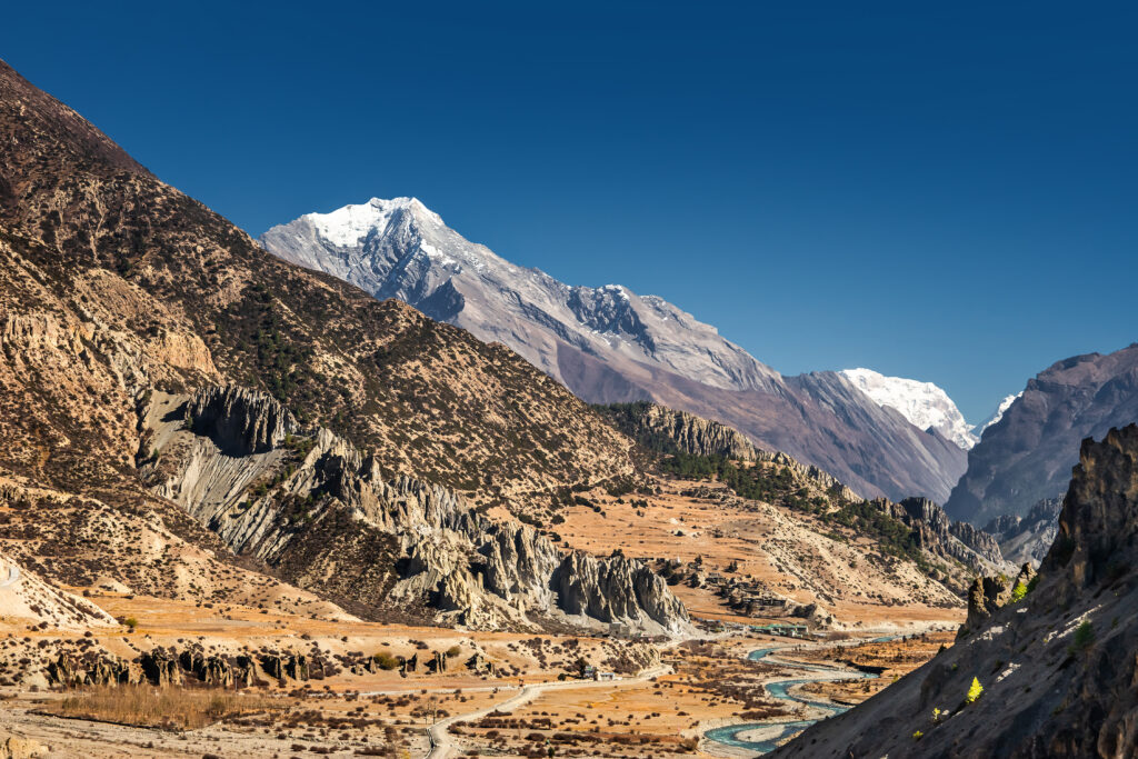
Pisang Peak rises to 6,091 m (19,983 ft) in the Manang District of Gandaki Province in northern Nepal — a pyramid-shaped summit rising directly above Pisang village in the upper Marsyangdi Valley on the classic Annapurna Circuit trekking route. The peak is also known by its local Tibetan-influenced name Jong Ri. Pisang Peak holds particular significance among Nepal’s trekking peaks as the most popular and accessible NMA Group A climbing peak in the Annapurna region, classified PD (Peu Difficile) on the alpine grading scale and offering a true 6,000 m summit experience with manageable technical demands.
Pisang Peak was first climbed in 1955 by a German expedition — the clearest first ascent documentation among Nepal’s popular trekking peaks. The first ascent occurred relatively early in Himalayan mountaineering history, before many of the more famous Khumbu trekking peaks were first climbed. The German expedition established the standard southeast ridge route that essentially all subsequent climbers have followed — a well-defined ridge leading to a final snow slope with fixed ropes through the steeper sections, capped by the pyramidal summit. The route has remained largely unchanged in its seventy years of climbing history.
The peak’s accessibility differs fundamentally from the simpler Yala Peak experience in the Langtang region. Pisang Peak requires a Nepal Mountaineering Association climbing permit at approximately USD 250 — unlike Yala Peak which has no climbing permit requirement since the 2011 NMA policy change for peaks below 5,800 m. Pisang Peak at 6,091 m sits firmly above that threshold and remains in the NMA permit system. Climbers also need an Annapurna Conservation Area Project (ACAP) entry permit and a TIMS card. The full permit package represents standard NMA trekking peak documentation but adds substantial cost compared to Yala Peak.
The Annapurna Circuit integration represents Pisang Peak’s most distinctive characteristic among Nepal’s trekking peaks. The base camp sits at 4,380 m on a Kharka (yak pasture) reached by a simple side trek from Pisang village at 3,300 m — itself a standard overnight stop on the Annapurna Circuit. Combined Pisang Peak plus Annapurna Circuit itineraries provide both the 6,000 m summit experience and the complete 18-21 day Annapurna Circuit including the Thorong La Pass crossing at 5,416 m — one of the highest trekking passes in the world. The combined experience captures the iconic Annapurna Circuit while adding a meaningful technical summit, making the trip dramatically more comprehensive than either trek or climb alone.
The summit panorama from Pisang Peak ranks among the most spectacular accessible views in the Nepali Himalaya. The view encompasses Manaslu at 8,163 m, Annapurna II at 7,937 m, Annapurna III, Annapurna IV at 7,525 m, Gangapurna at 7,455 m, Tilicho Peak at 7,134 m, and the broader Annapurna massif. The Chulu range dominates the immediate northern view while the Damodar Himal extends eastward. Annapurna I at 8,091 m and Dhaulagiri at 8,167 m frame the broader panorama. This complete 2026 guide covers verified route descriptions, current NMA permit requirements, gear lists, the 1955 first ascent story, the 50 percent summit success rate context, and the broader Annapurna region context that makes Pisang Peak one of the most popular 6,000 m climbing objectives in Nepal.
Live Pisang Peak Operations Center
Real-time location intelligence and Manang Valley region weather conditions
Pisang Peak holds a distinctive position in Nepal’s trekking peak catalog as the most popular and accessible NMA Group A climbing peak in the Annapurna region. The pyramidal 6,091 m summit rises above Pisang village on the classic Annapurna Circuit, offering a true 6,000 m climbing experience with PD-grade technical demands manageable for climbers with prior high-altitude trekking experience. The peak combines the iconic Annapurna Circuit trekking experience with a genuine technical summit attempt, making the combined trip dramatically more comprehensive than either component alone.
The peak’s history traces to a clear 1955 first ascent by a German expedition — distinguishing Pisang Peak from many Nepali trekking peaks with unclear or contested first ascent records. The German expedition established the standard southeast ridge route that essentially all subsequent climbers have followed. The route’s seventy-year climbing history has produced thousands of successful ascents while maintaining roughly 50 percent summit success rate — reflecting the genuine technical and altitude demands beyond a simple hike.
Pisang Peak’s permit requirements distinguish it from the simpler Yala Peak experience in the Langtang region. Pisang Peak at 6,091 m sits firmly above the 5,800 m threshold below which NMA removed climbing permit requirements in 2011. Climbers need a full NMA climbing permit at approximately USD 250, an Annapurna Conservation Area Project entry permit, and a TIMS card. A NMA Liaison Officer is assigned. The permit package costs substantially more than Yala Peak but represents standard NMA trekking peak documentation. Allow 1-3 weeks for permit processing before the trip.
The standard climbing route reflects Pisang Peak’s PD grade. The base camp at 4,380 m on a yak pasture (Kharka) is reached by a simple side trek from Pisang village. From base camp, climbers establish a high camp at 5,400 m by climbing to a shoulder on the southwest ridge. The summit day involves a 10-hour effort to the 6,091 m summit via the well-defined ridge, with fixed ropes through the steeper sections of the final snow and ice slope. The climbing is more demanding than Yala Peak but considerably easier than Island Peak’s steep technical headwall. The western flank of the mountain is guarded by a hanging glacier and rock slabs that make alternative routes substantially more challenging.
The Annapurna Circuit integration makes Pisang Peak particularly attractive for combined climbing-trekking trips. The base camp sits adjacent to the standard Annapurna Circuit trail, allowing climbers to integrate the peak attempt into a full Circuit itinerary that crosses the iconic Thorong La Pass at 5,416 m to Muktinath, descends through the Kali Gandaki valley to Jomsom, and returns to Pokhara by flight or jeep. The full combined Pisang Peak plus Annapurna Circuit trip runs 18-21 days and captures one of the most comprehensive Himalayan trekking-climbing experiences available in Nepal.
The single most rewarding Pisang Peak experience combines the climb with the full Annapurna Circuit including the Thorong La Pass crossing. The 18-21 day combined itinerary begins with the classic Circuit approach from Besisahar through Dharapani and Chame to Upper Pisang, then incorporates 4-5 days for the Pisang Peak attempt with base camp at 4,380 m and high camp at 5,400 m. After summit, the route continues along the Circuit through Manang, Yak Kharka, and Thorong Phedi to the Thorong La Pass (5,416 m), descends to Muktinath, and finishes in Jomsom for a flight to Pokhara. The combined experience captures the iconic Annapurna Circuit while adding a meaningful 6,000 m technical summit — a trip dramatically more comprehensive than either component alone. The cost premium for the combined option over standalone Pisang Peak is modest given the dramatically expanded experience.
The most common question from prospective beginner Himalayan climbers concerns the choice between Pisang Peak (6,091 m) and Yala Peak (5,500 m). Pisang Peak advantages: true 6,000 m summit experience, more dramatic Annapurna massif views, full Annapurna Circuit integration possibility, clearer technical achievement and first ascent history. Yala Peak advantages: no NMA permit required since 2011 (Pisang requires $250 NMA permit), substantially lower cost ($1,400-2,800 vs $1,800-3,500), shorter itinerary (10-14 days vs 15-21 days), simpler non-technical climbing with no fixed ropes, closer to Kathmandu logistics. The honest answer: Yala Peak is the better first Himalayan summit for absolute beginners — simpler permits, lower cost, simpler climbing. Pisang Peak is the better choice for climbers who have completed Yala Peak or similar high-altitude trekking and are ready for their first genuine 6,000 m technical summit.
This guide consolidates information from the Nepal Mountaineering Association (NMA), Nepal Ministry of Tourism, Annapurna Conservation Area Project (ACAP), Nepal Tourism Directory NMA peak catalog, and active Nepali expedition operator information including Sherpa Expedition & Trekking, Yatri Trekking, Highland Expeditions, 8K Expeditions, Asian Hiking Team, Nepal Independent Guide, Snowy Horizon, and Mountain Ram Adventures. The 1955 German first ascent is documented across multiple operator sources and represents the standard first ascent date for Pisang Peak. The 6,091 m elevation is consistent across all authoritative sources. The PD grade classification follows standard alpine grading conventions. Every elevation, permit cost, and itinerary detail reflects 2026 conditions confirmed through May 2026.
At a Glance: Pisang Peak Essentials
Pisang Peak combines a genuine 6,000 m summit experience with PD-grade technical demands and full Annapurna Circuit integration. The following statistics summarize the key parameters every climber must understand before planning a trip. Each figure below reflects 2026 conditions verified through the Nepal Mountaineering Association and active expedition operators.
Eight Reasons Climbers Choose Pisang Peak
Pisang Peak holds a unique position among NMA Group A trekking peaks. The reasons climbers target this summit combine the genuine 6,000 m achievement, the Annapurna Circuit integration, the clearly documented 1955 German first ascent, and the spectacular summit panorama that includes Manaslu, the Annapurna massif, and Tilicho Peak.
True 6,000 m Summit Experience
Pisang Peak at 6,091 m delivers a genuine 6,000 m summit experience — a meaningful achievement that exceeds the 5,000 m hiking viewpoints and the 5,500 m Yala Peak. The summit elevation places climbers higher than 99.9 percent of humans will ever stand without supplemental oxygen, making the 6,000 m threshold a significant personal accomplishment.
Annapurna Circuit Integration
Pisang Peak’s position above Pisang village on the standard Annapurna Circuit makes it uniquely combinable with one of the world’s most iconic treks. The 18-21 day combined itinerary captures both the full Annapurna Circuit including the Thorong La Pass and a 6,000 m summit attempt — substantially more comprehensive than either experience alone.
Clear 1955 First Ascent History
Pisang Peak’s 1955 German first ascent provides the clearest documented climbing history among Nepal’s popular trekking peaks. The well-established route, the seventy-year climbing tradition, and the consistent technical character give the peak a sense of established mountaineering credibility that newer trekking peaks lack.
Spectacular Annapurna Panorama
The summit view encompasses Manaslu (8,163 m), Annapurna II (7,937 m), Annapurna IV (7,525 m), Gangapurna (7,455 m), Tilicho Peak (7,134 m), the Chulu range, and the broader Annapurna massif. The panorama ranks among the most spectacular accessible views in the Nepali Himalaya.
PD Grade Manageable Technical Climbing
The PD (Peu Difficile) grade represents accessible technical mountaineering — non-technical for most of the route with fixed ropes through the steeper summit sections. Climbers gain genuine technical climbing experience without the steep technical headwalls of Island Peak or the glacier complexity of Mera Peak.
Cultural Depth of Manang District
The Manang District offers immersive cultural experience with Gurung, Ghale, and Tibetan-influenced communities. The traditional villages of Upper Pisang, Ngawal, and Manang preserve centuries-old Buddhist culture. The 700-year-old monasteries and the high-altitude lifestyle add cultural depth that matches the climbing achievement.
Lower Cost Than Khumbu Peaks
Pisang Peak trip costs run USD 1,800-3,500 — substantially lower than Khumbu region climbing peaks like Ama Dablam ($6,500-10,000), and slightly lower than Island Peak ($2,000-4,500). The cost advantage reflects the simpler overland logistics, the shorter overall trip duration, and the absence of Lukla flight requirements.
Less Crowded Than Khumbu Peaks
The Annapurna region sees substantial trekker traffic on the standard Circuit but Pisang Peak itself sees far fewer climbers than Island Peak or Mera Peak. Climbers experience a quieter, more intimate climbing environment with smaller team sizes and more personal interactions with local communities throughout the trip.
Who Can Climb Pisang Peak
Pisang Peak suits climbers with reasonable cardiovascular fitness, prior high-altitude trekking experience, and willingness to commit to basic technical climbing. The standard 15-21 day itinerary demands 5-7 hours of trekking per day for approximately one week to reach base camp, then a strenuous 10-hour summit day on technical terrain. The PD grade involves fixed-rope climbing through the steeper sections — beginner mountaineering skills are essential.
The standard itinerary builds in adequate acclimatization through the multi-day Annapurna Circuit approach. Climbers spend nights at progressively higher elevations through Bhulbhule (800 m), Jagat (1,300 m), Dharapani (1,900 m), Chame (2,700 m), Upper Pisang (3,300 m), and finally base camp at 4,380 m. The graduated elevation profile reduces altitude sickness risk substantially but cannot eliminate it. Approximately 47 percent of normal sea-level oxygen pressure exists at the Pisang Peak summit elevation.
For climbers without prior 6,000 m experience, Pisang Peak represents a reasonable first 6,000 m objective when approached with appropriate preparation. The peak is widely considered easier than Island Peak and Mera Peak — the other popular NMA trekking peaks at similar elevations. Many operators recommend Pisang Peak specifically for climbers who completed Yala Peak (5,500 m) or similar high-altitude trekking experience and are ready to step up to a genuine 6,000 m technical summit.
For climbers with prior Himalayan experience, Pisang Peak fits naturally into broader Annapurna region itineraries. The combined Pisang Peak plus Annapurna Circuit trip (18-21 days) provides comprehensive Annapurna experience. Climbers seeking harder Annapurna peaks can progress to Chulu West (6,419 m), Chulu East (6,584 m), or eventually Tilicho Peak (7,134 m) — though Tilicho is an expedition peak requiring full NMA expedition permits. Pisang Peak serves as excellent acclimatization preparation for harder Annapurna or Manaslu region objectives.
Climbers should be capable of sustained 5-7 hour hiking days for one week with cumulative elevation gain to 6,091 m. The 10-hour summit day from base camp at 4,380 m to summit and return demands serious endurance. The technical demands are modest — climbers need basic mountaineering equipment skills including crampon walking, ice axe use, and fixed-rope climbing with jumar ascender and figure-8 descender. Most operators include a climbing course at base camp before the summit push to teach essential skills. Climbers without prior mountaineering experience can typically learn the required techniques in the base camp training session, but those expecting to pass the steep summit slope safely should have a comfort level with exposed climbing situations. The roughly 50 percent summit success rate reflects altitude, weather, and decisions to turn around when conditions exceed personal capability — these are normal outcomes rather than failures.
Pisang Peak in the Annapurna Context
Pisang Peak occupies a central position in the Manang District of the upper Marsyangdi Valley, the northern half of the classic Annapurna Circuit trekking route. The peak sits inside the Annapurna Conservation Area — the largest protected area in Nepal at approximately 7,629 square kilometers — between the Annapurna massif to the south and the Damodar Himal to the east. The pyramidal Pisang Peak summit dominates the immediate horizon above Pisang village and provides one of the most spectacular Annapurna region views accessible from a trekking peak summit.
The Annapurna region hosts some of the most famous mountaineering peaks in Nepal. Annapurna I at 8,091 m is the 10th highest mountain in the world and the first 8,000 m peak ever climbed (Herzog and Lachenal, 1950). Annapurna II at 7,937 m, Annapurna III, Annapurna IV at 7,525 m, and Gangapurna at 7,455 m complete the major Annapurna group. Dhaulagiri at 8,167 m sits across the Kali Gandaki valley to the west. Manaslu at 8,163 m, the world’s eighth-highest peak, lies to the east. Tilicho Peak at 7,134 m sits west of Manang. The Chulu range with Chulu West (6,419 m), Chulu East (6,584 m), and Chulu Far East (6,059 m) provides the trekking peak group north of Manang.
For climbers planning regional progressions, Pisang Peak pairs naturally with several Annapurna objectives. The Chulu Far East (6,059 m) provides a slightly easier alternative NMA trekking peak in the same region. Chulu West (6,419 m) and Chulu East (6,584 m) offer harder progressions with glacier travel and more committed technical climbing. Singu Chuli or Fluted Peak (6,501 m) and Hiunchuli (6,441 m) in the Annapurna Sanctuary represent harder Annapurna trekking peak progressions. For cross-region progressions to harder peaks, climbers typically target Island Peak (6,189 m) or Mera Peak (6,476 m) in the Khumbu region as natural next steps.
The Pisang Peak Companion Objectives
Pisang Peak shares the NMA trekking peak category with several iconic climbing destinations across Nepal. The six peaks below provide alternative or progression objectives for climbers building their Himalayan resume.
Pisang Peak History: From 1955 German First Ascent to Modern Popular Peak
Pisang Peak’s history begins with one of the clearest first ascent records among Nepal’s popular trekking peaks. The 1955 German expedition that established the standard route represents an unambiguous starting point for the peak’s climbing history, in contrast to many Nepali trekking peaks where first ascent records are unclear or contested.
Pre-1955: Local Gurung and Tibetan presence
The Manang District has been inhabited for centuries by Gurung, Ghale, and Tibetan-influenced communities. The Marsyangdi Valley served as a traditional trade route between the lower Nepali hills and the Tibetan Plateau, with the high-altitude villages of Pisang, Ngawal, and Manang developing as trading and pastoral settlements. Yak grazing at the Pisang Kharka (the current base camp area) at 4,380 m has been part of traditional life for many generations. The Tibetan-influenced name Jong Ri reflects the cultural heritage of the region — Buddhist traditions remain central to local life.
1949: Annapurna region opens to international exploration
Following the 1949 opening of Nepal to international visitors, exploratory expeditions began entering the Annapurna region. The 1950 French Annapurna I expedition led by Maurice Herzog and Louis Lachenal achieved the first ascent of any 8,000 m peak, dramatically increasing international interest in the region. The exploratory work of subsequent expeditions identified Pisang Peak as a worthwhile climbing objective.
1955: German First Ascent
A German expedition made the first ascent of Pisang Peak in 1955, just five years after the Annapurna I first ascent. The expedition established the standard southeast ridge route that essentially all subsequent climbers have followed. The German team approached from Pisang village, established a base camp at the Kharka at 4,380 m, and completed a single high camp at 5,400 m before the summit attempt. The route’s relative simplicity — a well-defined ridge with manageable technical demands — distinguished Pisang Peak from harder technical objectives in the region.
1970s-1980s: Annapurna Circuit development
The Annapurna Circuit emerged as one of the most popular international trekking routes through the 1970s and 1980s. The standard route from Besisahar through Manang and Thorong La Pass to Muktinath and Jomsom developed teahouse infrastructure that supported both trekkers and climbing expeditions. Pisang Peak benefited from the trekking infrastructure since its base camp lies just a few hours from Pisang village on the standard Circuit route.
1986: Annapurna Conservation Area Project (ACAP)
The Annapurna Conservation Area Project was established in 1986 to manage the rapidly growing trekking economy in the region. ACAP became the largest protected area in Nepal at approximately 7,629 square kilometers. The conservation area framework formalized the trekking and climbing permit system that today governs Pisang Peak access. Visitors must obtain ACAP entry permits along with TIMS cards and NMA climbing permits for trekking peak attempts.
1990s: NMA trekking peak system formalization
Through the 1990s, the Nepal Mountaineering Association formalized the trekking peak system that classifies peaks into different categories with permit requirements proportional to technical difficulty and elevation. Pisang Peak was classified as a Group A trekking peak — the standard category for accessible 6,000 m and lower peaks open to international climbers. The Group A classification established the permit fee structure and the requirements for registered Nepali operator coordination.
2000s: Commercial expedition growth
Through the 2000s, commercial Pisang Peak expedition programs expanded dramatically as international interest in NMA trekking peaks grew. Operators developed the standard 15-21 day Pisang Peak itinerary including the Annapurna Circuit integration option. The peak’s reputation as a manageable first 6,000 m experience attracted growing numbers of climbers seeking introduction to technical Himalayan mountaineering. The 50 percent summit success rate became established as the typical outcome for commercial expeditions.
2011: NMA permit policy clarification
While the 2011 NMA policy change removed climbing permits for peaks below 5,800 m, Pisang Peak at 6,091 m remained firmly within the permit requirement system. The clarification reinforced Pisang Peak’s status as a true NMA trekking peak with full permit and Liaison Officer requirements. The distinction between Pisang Peak’s permit-required status and Yala Peak’s permit-free status (since 2011) became one of the defining differences between the two popular beginner-friendly Himalayan trekking peaks.
2015 Earthquake regional impact
The April 2015 Nepal earthquake had less direct impact on the Manang District compared to the catastrophic Langtang Valley damage, but the broader Nepali trekking economy suffered significant disruption. The Annapurna region recovered relatively quickly through 2016-2017 as international trekkers returned. The Manang infrastructure was largely unaffected, allowing the Pisang Peak commercial expedition format to continue with minimal interruption.
2020-2022: COVID-19 suspension and recovery
The COVID-19 pandemic temporarily suspended all Nepali trekking from March 2020 through late 2021. Pisang Peak climbing essentially halted during this period. The region rebounded through 2022, 2023, and into the current 2026 seasons as international climbers returned. Annual visitor numbers in 2026 have approached pre-pandemic levels.
Current 2026 status
Pisang Peak in 2026 remains the most popular NMA Group A trekking peak in the Annapurna region. The well-established commercial expedition format, the seventy-year climbing tradition since the 1955 German first ascent, and the natural integration with the Annapurna Circuit make Pisang Peak particularly accessible. Multiple registered Nepali operators offer Pisang Peak programs ranging from budget group expeditions to premium private climbs. The peak’s position as a meaningful first 6,000 m summit experience continues to attract climbers progressing from lower-elevation trekking peaks.
Climbing Routes on Pisang Peak
Pisang Peak’s route catalog centers on the standard southeast ridge route established by the 1955 German first ascent expedition. The route accounts for essentially all commercial climbs. Alternative routes including the southwest ridge variation and approaches to the western flank exist but see only occasional attempts. The western flank is notably guarded by a hanging glacier and huge rock slabs that make alternative routes substantially more challenging.
| Route | Grade | First Ascent | Summit Day | Equipment | Frequency |
|---|---|---|---|---|---|
| Southeast Ridge (Standard) | PD | 1955 German expedition | 10 hours | Crampons, axe, fixed ropes | ~97% of climbs |
| Southwest Ridge Variation | PD+ | Modern variation | 10-12 hours | Crampons, axe, more ropes | ~2% of climbs |
| West Face (rare) | AD+ to D | Occasional attempts | 12-15 hours | Technical hanging glacier | <1% of climbs |
Southeast Ridge — The Classic Pisang Peak Route
The southeast ridge route established by the 1955 German first ascent expedition serves as the standard approach on Pisang Peak. The route follows a well-defined ridge from Pisang Kharka base camp at 4,380 m through a shoulder high camp at 5,400 m to the 6,091 m summit pyramid. The climbing involves crampons, an ice axe, and fixed ropes through the steeper sections of the final snow slope.
Approach phase: Climbers begin from Kathmandu with a 6-7 hour drive to Besisahar at 760 m, then jeep transfer to Dharapani at 1,650-1,900 m. From Dharapani, the trail follows the Marsyangdi River through Chame at 2,670-2,713 m and continues to Upper Pisang at 3,300 m. The approach takes 4-6 days following the standard Annapurna Circuit route with acclimatization at multiple stops. Lower elevations are dominated by rhododendron and oak forests transitioning to alpine terrain as the trail climbs.
Acclimatization at Upper Pisang: Most expeditions include a rest day at Upper Pisang for acclimatization. Climbers can hike to Ngawal (3,600 m) or explore the upper Pisang area to enhance acclimatization. The Tibetan-influenced Gurung culture of the upper Manang valley adds cultural depth during the rest day. From Upper Pisang the dramatic pyramidal Pisang Peak rises directly above the village, providing immediate visual confirmation of the climbing objective.
Base camp establishment: The Pisang Kharka base camp at 4,380 m is reached by a 3-4 hour ascent from Upper Pisang through sparse forest and yak pasture (Kharka in Nepali). The base camp sits on a meadow with excellent views of Pisang Peak and the surrounding Annapurna massif. Most operators camp at base camp for 2-3 nights including a rest day and a climbing course day before the summit push.
Climbing course day: Most operators include a dedicated climbing course day at base camp before the summit push. The course teaches essential skills including crampon walking on snow and ice, ice axe self-arrest, fixed-rope ascending with a jumar, and fixed-rope descending with a figure-8 descender. Climbers without prior mountaineering experience can typically learn the required techniques in this base camp training session.
High camp and summit day: Day before summit attempt, climbers ascend from base camp at 4,380 m to the high camp at 5,400 m by climbing to a shoulder on the southwest ridge. The high camp involves 4-5 hours of ascent. The summit day starts pre-dawn (2:00-3:00 AM) and involves 5-7 hours ascending the well-defined ridge to the final snow slope. The final snow slope has fixed ropes through the steeper sections leading to the pyramidal summit at 6,091 m. After 30-60 minutes at the summit, climbers descend to high camp or directly to base camp — a total 10-hour effort from high camp.
Southwest Ridge Variation
The southwest ridge variation offers a slightly more technical alternative to the standard southeast ridge. The route involves more fixed-rope sections and tougher snow conditions on the steeper portions. Climbers seeking a slightly more challenging Pisang Peak experience can request this variation from operators with documented experience on the route.
The southwest variation sees only occasional attempts — most operators default to the standard southeast ridge for its proven reliability and seventy-year climbing history. Climbers interested in the southwest ridge should specifically request operators with documented experience on this aspect and accept potentially longer summit days.
West Face — Technical Hanging Glacier Route
The west face represents the most technical approach to Pisang Peak. The western flank is guarded by a hanging glacier and huge rock slabs that make the route substantially more challenging than the standard southeast ridge. Access to the western end of the ridge is problematic due to the rock slabs.
The west face sees only rare technical attempts by experienced alpine climbing teams. The route is graded AD+ to D depending on conditions and represents a serious technical undertaking far beyond the trekking peak character of the standard route. The west face is not appropriate for commercial expeditions and requires substantial prior alpine climbing experience.
Pisang Peak Access & Permits 2026
Pisang Peak access requires a full Nepal Mountaineering Association climbing permit because the peak exceeds the 5,800 m threshold below which NMA removed permit requirements in 2011. The full permit package costs substantially more than the simpler-permit Yala Peak but represents standard NMA trekking peak documentation.
Pisang Peak requires a Nepal Mountaineering Association Group A climbing permit at approximately USD 250 for spring and autumn climbing seasons (cheaper in winter and monsoon — typically USD 70-125). Climbers also need an Annapurna Conservation Area Project (ACAP) entry permit at approximately USD 30 and a TIMS card at approximately USD 10-20. An NMA Liaison Officer is assigned. Permits are obtained by registered Nepali trekking operators on behalf of clients — most operators include all permits in their trip packages. Allow 1-3 weeks for permit processing before the trip start.
Required documentation for 2026
- NMA Group A climbing permit: Mandatory for Pisang Peak as it exceeds 5,800 m threshold
- Annapurna Conservation Area Project (ACAP): Entry permit for the conservation area
- TIMS card: Trekkers’ Information Management System registration
- Nepali visa: Tourist visa available on arrival or in advance through Nepali embassies
- Travel insurance: Comprehensive coverage including high-altitude climbing and helicopter rescue
- Registered operator: Required for permit coordination and Liaison Officer assignment
- Medical certificate: Recommended for older climbers or those with health conditions
2026 Permit cost breakdown
- NMA Group A climbing permit: USD 250 (spring/autumn), USD 125 (winter), USD 70 (monsoon)
- ACAP entry permit: NPR 3,000 per climber (approximately USD 30)
- TIMS card: NPR 1,000-2,000 (approximately USD 10-20)
- Nepali tourist visa: USD 30 (15 days), USD 50 (30 days), USD 125 (90 days)
- Travel insurance: USD 150-400 per climber for comprehensive climbing coverage
- Liaison Officer: Included in operator packages (food, accommodations, salary)
- Garbage management deposit: USD 250-500 per expedition (typically refundable)
Access logistics from Kathmandu
Pisang Peak is accessible from Kathmandu via an overland drive — no domestic flights required. Climbers drive from Kathmandu to Besisahar at 760 m (6-7 hours, approximately 190 km), then take a jeep to Dharapani at 1,650-1,900 m. From Dharapani, the trail follows the standard Annapurna Circuit route through Chame at 2,670-2,713 m to Upper Pisang at 3,300 m. The full approach takes 5-6 days from Kathmandu including the drive and acclimatization stops at lower elevations. From Upper Pisang, the trail ascends 3-4 hours to Pisang Kharka base camp at 4,380 m. The complete trip including climbing and return runs 15-21 days from Kathmandu.
Pisang Peak Climbing Costs in 2026
Pisang Peak climbing costs run substantially lower than Khumbu region climbing peaks like Ama Dablam but slightly higher than the simpler-permit Yala Peak. The NMA climbing permit at $250 represents the main cost differentiator from Yala Peak. Fully guided programs run USD 1,800-3,500 per person depending on service level. Combined Pisang Peak plus Annapurna Circuit packages reach USD 2,500-4,500. All costs reflect 2026 conditions verified through active Nepali operators including Sherpa Expedition & Trekking, Yatri Trekking, Highland Expeditions, 8K Expeditions, Asian Hiking Team, Snowy Horizon, Mountain Ram Adventures, and similar registered companies.
Budget Guided Pisang Peak Climb (Group)
The most affordable Pisang Peak climbing option involves group climbs with experienced English-speaking guides and shared porter support. Costs include the NMA Group A climbing permit, ACAP and TIMS permits, registered guide and climbing assistant services, teahouse accommodations during the approach trek, camping at base camp and high camp, basic climbing equipment (typically crampons, ice axe, and harness provided), and three daily meals during the trip. The lower price reflects shared group services rather than reduced quality.
Standard Private Guided Climb
Most international climbers select the standard private guided climbing format. This tier provides personalized attention with a dedicated experienced climbing guide and a climbing assistant for the summit push. The cost includes complete logistics from Kathmandu arrival through trip completion and return, comfortable teahouse accommodations on the Annapurna Circuit approach, base camp and high camp camping, three meals daily, hotel nights in Kathmandu before and after the climb, and all permits and equipment.
Premium Small-Group Climb
Premium Pisang Peak climbs feature experienced senior climbing guides with Khumbu-level credentials, the best available teahouse accommodations during the approach, premium hotel stays in Kathmandu, helicopter contingency options for emergencies, and higher guide-to-climber ratios for the technical climbing portion. The premium option suits climbers seeking optimal support for their first 6,000 m summit experience.
Pisang Peak + Full Annapurna Circuit Trek
The combined Pisang Peak plus Annapurna Circuit option represents the most comprehensive trip available. The 18-21 day itinerary incorporates the Pisang Peak summit attempt with the full Annapurna Circuit including the Thorong La Pass crossing at 5,416 m to Muktinath, the Kali Gandaki valley descent to Jomsom, and the flight back to Pokhara. This option captures both the iconic Annapurna Circuit and the 6,000 m summit experience in a single trip. The cost premium reflects the extended duration rather than premium service level.
Custom Annapurna Multi-Peak Expedition
Custom multi-peak Annapurna expeditions combine Pisang Peak with Chulu Far East (6,059 m) — a slightly easier NMA trekking peak in the same region. The combined climbing experience provides progression with two 6,000 m summits in a single trip. Some operators offer Pisang Peak combined with Chulu West (6,419 m) for climbers seeking more challenging progression. The combined programs typically run 25-30 days and demand serious commitment from climbers and budgets.
Essential Gear for Pisang Peak Expedition
Gear requirements for Pisang Peak require full technical mountaineering equipment including fixed-rope hardware. The PD-grade summit ridge involves crampons, ice axe, harness, jumar ascender, and figure-8 descender for the fixed-rope sections. Many operators provide basic climbing equipment in their packages — confirm specifically what is included before bringing personal equipment.
Mountaineering Boots (Mandatory)
- Double mountaineering boots rated for -30°C minimum
- La Sportiva G2 SM, Scarpa Phantom 6000, or similar double-boot construction
- Compatible with 12-point automatic crampons
- Well-broken-in before the trip
Climbing Hardware (Mandatory)
- 12-point general mountaineering crampons (Petzl Sarken or Vasak, Black Diamond Sabretooth)
- Standard ice axe with adze (Petzl Glacier, Black Diamond Raven)
- Climbing harness with adjustable leg loops
- Jumar ascender for fixed-rope sections
- Figure-8 descender or ATC for rappels
- Helmet for falling rock/ice protection
Cold-Weather Clothing (Mandatory)
- Heavy insulated down jacket (-30°C rated) for summit day
- Hardshell waterproof jacket and pants
- Down or synthetic insulating pants for summit day
- Fleece or synthetic insulating mid-layers
- Thermal base layers (merino or synthetic)
- Warm hat, balaclava, two pairs of gloves (light and heavy)
Sleeping System (Mandatory)
- Sleeping bag rated to -20°C minimum for high camp
- Sleeping bag liner for extra warmth
- Insulated sleeping pad with high R-value
Daypack and Trekking Poles
- 40-50L pack for summit day equipment
- Adjustable trekking poles (highly recommended)
- Hydration system or water bottles (2-3 liter capacity)
- Water purification tablets or filter
Sun and Eye Protection
- Glacier sunglasses with category 4 UV protection
- Sunscreen SPF 50+ for high-altitude UV intensity
- Lip balm with SPF protection
- Reserve glasses or contact lens supplies
Navigation and Safety
- Headlamp with extra batteries (mandatory for 2-3 AM summit start)
- Whistle and emergency signaling device
- Power bank for phone and electronics charging
- Optional GPS device with offline maps
Medical and Personal
- Diamox or similar altitude prophylaxis (consult physician)
- Personal first aid kit with basic medications
- Hand sanitizer and personal hygiene items
- Quick-dry towel and travel essentials
Hazards on Pisang Peak
Pisang Peak’s hazard profile combines altitude risks with PD-grade technical climbing hazards. The 6,091 m summit elevation puts climbers at approximately 47 percent of sea-level oxygen pressure. The fixed-rope summit slope adds technical hazards beyond pure altitude exposure. Climbers must understand and prepare for both categories of hazard.
Acute mountain sickness (AMS)
Altitude sickness represents the primary serious hazard. Early symptoms include headache, dizziness, loss of appetite, difficulty sleeping, and fatigue. Severe AMS can progress to HAPE or HACE — both potentially fatal conditions requiring immediate descent. The graduated Annapurna Circuit approach with acclimatization stops reduces but does not eliminate AMS risk. Diamox prophylaxis is sometimes recommended; consult a physician before the trip.
Steep summit slope with fixed ropes
The final summit slope is steep snow and ice with fixed ropes through the sketchier sections. Climbers must be comfortable with fixed-rope ascending using a jumar and fixed-rope descending using a figure-8 or ATC. The exposure on the summit ridge is significant — a fall would be serious. Most operators provide essential safety equipment and supervise fixed-rope technique throughout the climbing day.
Unpredictable mountain weather
The Annapurna region experiences variable weather with monsoon-bracketed climbing windows. Clear morning skies can deteriorate to whiteout conditions within hours. Wind speeds on the summit can be severe. The pre-dawn summit hike means climbers commit to weather conditions during darkness without full visibility of developing patterns. Weather monitoring throughout the trip is essential.
Western flank hanging glacier hazard
The western flank of Pisang Peak is guarded by a hanging glacier with potential rockfall and ice fall hazards. The standard southeast ridge route avoids this hazard area, but climbers must respect operator guidance about routes and timing. The huge rock slabs that guard access to the western end of the ridge create natural hazards that have shaped the route selection over seventy years of climbing history.
Cold weather and frostbite risk
Summit-zone temperatures can drop to -20°C to -30°C during winter conditions or pre-dawn summit pushes, with wind chill compounding the cold significantly. Frostbite risk exists for inadequately prepared climbers, particularly on extremities during the long summit day. Proper layering, vapor barriers, and aggressive temperature management throughout the climb are essential.
Overland travel reliability
Unlike Khumbu treks that depend on the famously unreliable Lukla flights, Pisang Peak trips depend on the overland drive from Kathmandu to Besisahar and the jeep transfer to Dharapani. The mountain road can be affected by landslides, monsoon damage, or political demonstrations that block traffic. Trip timelines should include buffer time for transportation delays. Emergency evacuation requires helicopter service from the Manang region to Kathmandu.
Dehydration
High-altitude dehydration occurs more rapidly than at sea level due to dry air, increased breathing rate, and physical exertion. Climbers must consume 3-4 liters of water daily to maintain hydration. Symptoms of dehydration mimic AMS symptoms and can compound altitude problems.
Safety Protocols for Pisang Peak
Successful Pisang Peak climbs depend on conservative decision-making throughout the trip, particularly regarding altitude acclimatization and the technical summit day. The standard itinerary’s acclimatization at Chame, Upper Pisang, and base camp are essential. The base camp climbing course day is not optional — climbers must learn fixed-rope technique before the summit attempt. Climbers experiencing significant AMS symptoms must descend immediately rather than push toward the summit.
File detailed itineraries with both your registered Nepali operator and your home country embassy. Carry comprehensive travel insurance including helicopter rescue coverage — helicopter evacuation from the Manang region is expensive without insurance. Register with embassy services before the trip. Maintain regular communication with operators and family during the trip. Most expedition operators provide satellite phone or InReach contact. The decision to turn around at any point if conditions or personal capability indicate problems is always appropriate — Pisang Peak’s roughly 50 percent summit success rate reflects honest decisions to descend when summit conditions exceed personal limits, not failures.
When to Climb Pisang Peak
Seasonal timing on Pisang Peak follows the monsoon-bracketed pattern typical of the Nepal Himalaya. Two distinct climbing windows operate annually, with both providing viable conditions for the standard southeast ridge route.
Pre-monsoon (March-May)
March through May provides one of the two primary climbing seasons. April and May offer warmer temperatures with longer days and rhododendron forests blooming on the lower Marsyangdi Valley approach. The trail is dry and the weather is generally stable. Mountain views may be slightly hazier than autumn due to atmospheric dust and humidity. April-May represents one of the most popular spring windows.
Mid-monsoon (June-August)
June through August is not recommended for Pisang Peak climbing due to heavy rainfall, dangerous trail conditions, and obscured views. Some operators offer reduced-permit-cost monsoon-season climbs for climbers with very flexible schedules, but mountain visibility is typically poor and the experience falls short of dry-season expectations.
Post-monsoon (September-November)
September through November represents the most popular Pisang Peak climbing season. October and November offer the most stable weather with crystal-clear morning skies. Stable post-monsoon high pressure systems often bring weeks of consecutive clear days. Temperatures remain comfortable for daytime trekking with cold but manageable nights at higher elevations. The post-monsoon window combines the best weather, the clearest views, and the most reliable overland travel conditions.
Winter (December-February)
Winter climbing is possible for experienced climbers willing to accept significantly colder temperatures, shortened daylight, and increased technical difficulty from snow accumulation. Temperatures drop dramatically, snow accumulation increases summit ridge difficulty, daylight hours shorten reducing comfortable climbing windows, and some higher teahouses may close for the season. NMA winter season permit fees are reduced. Winter is not appropriate for first-time 6,000 m climbers.
Notable Pisang Peak Expeditions
Pisang Peak’s expedition history centers on the foundational 1955 German first ascent and the broader development of the Annapurna region trekking economy that has made the peak one of Nepal’s most popular climbing objectives. The stories below document the key milestones from first ascent through current 2026 operations.
1955 German First Ascent
First AscentA German expedition made the first ascent of Pisang Peak in 1955, just five years after the 1950 Annapurna I first ascent opened the region to international climbing. The expedition established the standard southeast ridge route from Pisang village through a base camp and single high camp to the summit. The route has remained essentially unchanged in its seventy years of subsequent climbing history.
1950 Annapurna I Regional Context
8,000m FAThe 1950 French Annapurna I first ascent led by Maurice Herzog and Louis Lachenal opened the broader Annapurna region to international climbing attention. The 8,091 m first ascent was the first 8,000 m peak ever climbed and dramatically increased global interest in the region, paving the way for subsequent expeditions including the 1955 Pisang Peak German team.
1970s-1980s Annapurna Circuit Development
Infrastructure builtThe Annapurna Circuit emerged as one of the most popular international trekking routes through the 1970s and 1980s. The standard route through Manang and Thorong La Pass developed teahouse infrastructure that supported both trekkers and climbing expeditions. Pisang Peak benefited from the trekking infrastructure since its base camp lies just hours from the standard Circuit route.
1986 ACAP Establishment
Conservation StatusThe Annapurna Conservation Area Project was established in 1986 to manage the rapidly growing trekking economy. ACAP became the largest protected area in Nepal at approximately 7,629 square kilometers. The conservation area framework formalized the trekking and climbing permit system that today governs Pisang Peak access.
1990s NMA Trekking Peak Formalization
Group A statusThe Nepal Mountaineering Association formalized the trekking peak system through the 1990s. Pisang Peak was classified as a Group A trekking peak — the standard category for accessible 6,000 m peaks open to international climbers. The classification established the permit fee structure and registered operator requirements.
2000s Commercial Expedition Era
Standard formatThrough the 2000s, commercial Pisang Peak expedition programs expanded dramatically. Operators developed the standard 15-21 day itinerary including the Annapurna Circuit integration option. The peak’s reputation as a manageable first 6,000 m experience attracted growing numbers of climbers. The 50 percent summit success rate became established as the typical commercial outcome.
2011 Permit Policy Clarification
Permit retainedWhile the 2011 NMA policy change removed climbing permits for peaks below 5,800 m, Pisang Peak at 6,091 m remained firmly within the permit requirement system. The clarification reinforced Pisang Peak’s status as a true NMA trekking peak with full permit and Liaison Officer requirements.
2026 Current Status
Popular destinationPisang Peak in 2026 remains the most popular NMA Group A trekking peak in the Annapurna region. The well-established commercial expedition format, the seventy-year climbing tradition since the 1955 German first ascent, and the natural Annapurna Circuit integration make Pisang Peak particularly accessible. The peak attracts climbers progressing from lower-elevation trekking peaks to their first 6,000 m summit.
Planning Your 2026 Pisang Peak Expedition
Pisang Peak planning involves the full NMA Group A trekking peak documentation process. The following planning categories cover the essential elements climbers must address before the trip.
Pisang Peak Frequently Asked Questions
How tall is Pisang Peak?
Pisang Peak rises to 6,091 m (19,983 ft) in the Manang District of Gandaki Province in northern Nepal. The elevation figure is consistent across authoritative sources including the Nepal Mountaineering Association classification and Wikipedia geographic data. The peak is also known by its local Tibetan-influenced name Jong Ri. The pyramid-shaped summit sits directly above Pisang village in the upper Marsyangdi Valley on the classic Annapurna Circuit trekking route. Pisang Peak represents one of the most accessible genuine 6,000 m summit experiences in Nepal.
Where is Pisang Peak located?
Pisang Peak rises in the northern part of the Manang District in Gandaki Province, eastern-central Nepal, at approximately 28.66°N, 84.16°E. The peak sits inside the Annapurna Conservation Area between the Annapurna massif to the south and the Manaslu range to the east. The pyramidal summit rises directly above Pisang village at 3,300 m on the upper Marsyangdi Valley section of the Annapurna Circuit. Access is from Kathmandu via a 6-7 hour drive to Besisahar, then jeep transfer to Dharapani, and trek through Chame to Upper Pisang.
When was Pisang Peak first climbed?
Pisang Peak was first climbed in 1955 by a German expedition — the clearest first ascent documentation among Nepal’s popular trekking peaks. The 1955 German first ascent established the standard southeast ridge route that essentially all subsequent expeditions have followed. The first ascent occurred relatively early in Himalayan mountaineering history, before many of the more famous Khumbu trekking peaks were first climbed. Pisang Peak has since become one of the most popular NMA trekking peaks in Nepal.
How difficult is Pisang Peak climbing?
Pisang Peak is graded PD (Peu Difficile or Slightly Difficult) on the standard alpine grading scale. The standard southeast ridge route is technically non-technical for most of the climb but involves a steep final snow slope with fixed ropes through the sketchier sections. The climbing involves crampons, an ice axe, and fixed-rope hardware including a harness, jumar, and figure-8 descender. The summit ridge is well-defined leading to a final snow and ice pyramid, with huge rock slabs guarding the western flank. The climbing is more demanding than Yala Peak but considerably easier than Island Peak’s steep technical headwall.
Do I need a permit for Pisang Peak?
Yes — Pisang Peak is an NMA Group A trekking peak and requires a Nepal Mountaineering Association climbing permit at approximately USD 250 for spring and autumn seasons. Climbers also need an Annapurna Conservation Area Project (ACAP) entry permit at approximately USD 30 and a TIMS card at approximately USD 10-20. Permits are obtained by registered Nepali trekking operators on behalf of clients. A NMA Liaison Officer is required for expeditions. The full permit package costs substantially more than the simpler-permit Yala Peak.
What can you see from Pisang Peak?
The Pisang Peak summit provides 360-degree views of one of the most spectacular Himalayan panoramas accessible from any trekking peak. The view encompasses Manaslu (8,163 m), Annapurna II (7,937 m), Annapurna III, Annapurna IV (7,525 m), Gangapurna (7,455 m), Tilicho Peak (7,134 m), and the broader Annapurna massif. The Chulu range to the north of Pisang dominates one direction while the Damodar Himal extends to the east. Annapurna I (8,091 m) and Dhaulagiri (8,167 m) are visible in the broader panorama.
How does Pisang Peak compare to Yala Peak?
Pisang Peak (6,091 m) and Yala Peak (5,500 m) represent two different levels of beginner-friendly Himalayan trekking peak experience. Pisang Peak is a true 6,000 m summit while Yala Peak is a 5,500 m peak. Pisang Peak requires an NMA climbing permit since it exceeds the 5,800 m threshold — Yala Peak requires no NMA permit. Pisang Peak involves fixed ropes on the steep summit slope — Yala Peak typically requires no fixed ropes. Pisang Peak takes 15-21 days versus 10-14 days for Yala Peak. Pisang Peak costs USD 1,800-3,500 versus USD 1,400-2,800 for Yala Peak. Yala Peak is the recommended first Himalayan peak for absolute beginners; Pisang Peak is the natural progression.
How is Pisang Peak combined with the Annapurna Circuit?
Pisang Peak’s position above Pisang village on the standard Annapurna Circuit trekking route makes it one of the most natural NMA peak combinations with a major trek. The standard 18-21 day combined itinerary follows the Annapurna Circuit from Besisahar through Dharapani, Chame, and Upper Pisang to the Pisang Peak Base Camp at 4,380 m. After the summit attempt, climbers descend to Manang and continue along the standard Circuit through Yak Kharka and Thorong Phedi to cross the Thorong La Pass at 5,416 m to Muktinath. The route then continues down to Jomsom for a flight back to Pokhara.
What is the best time to climb Pisang Peak?
The optimal climbing seasons run pre-monsoon March through May and post-monsoon September through November. Spring provides warmer temperatures with rhododendron forests blooming on the lower Marsyangdi Valley approach. Autumn offers the most stable post-monsoon high pressure with crystal-clear visibility and the most reliable mountain views. October-November is widely considered the optimal climbing window. Mid-monsoon June through August brings heavy rainfall and obscured views — climbing is technically possible but not recommended. Winter December through February is possible for experienced climbers willing to accept significantly colder temperatures.
How much does Pisang Peak climbing cost in 2026?
Pisang Peak climbing costs run USD 1,800 to 3,500 per person for fully guided programs in 2026, with combined Pisang Peak plus Annapurna Circuit packages reaching USD 2,500-4,500. Budget group climbs with shared services cost USD 1,800 to 2,200 per person. Standard guided climbs with private support run USD 2,200 to 2,800 per person. Premium small-group programs with elite guides and upgraded accommodations cost USD 2,800 to 3,500 per person. All tiers include the Nepal Mountaineering Association climbing permit (approximately USD 250), Annapurna Conservation Area Project permit, TIMS card, registered guide and climbing assistant services, teahouse accommodations during the trek, camping at base camp and high camp, basic climbing equipment, and meals.
Sources & Verified References
This Pisang Peak climbing guide consolidates information from the Nepal Mountaineering Association (NMA), Nepal Ministry of Tourism, Annapurna Conservation Area Project (ACAP), Nepal Tourism Directory NMA peak catalog, and active Nepali expedition operator information including Sherpa Expedition & Trekking, Yatri Trekking, Highland Expeditions, 8K Expeditions, Asian Hiking Team, Nepal Independent Guide, Snowy Horizon, and Mountain Ram Adventures. The 1955 German first ascent is documented across multiple operator sources. The 6,091 m elevation is consistent across all authoritative sources. The PD grade classification follows standard alpine grading conventions. Every elevation, permit cost, and itinerary detail reflects 2026 conditions confirmed through May 2026.
- Nepal Mountaineering Association (NMA) — Group A trekking peak permit system
- Nepal Ministry of Tourism — Mountaineering regulation framework
- Annapurna Conservation Area Project (ACAP) — Conservation area permits
- Nepal Tourism Directory NMA peak catalog — PD grade classification
- 1955 German Pisang Peak first ascent — Historical record
- 1950 French Annapurna I first ascent — Regional historical context
- Active Nepali expedition operators — Current 2026 trip logistics and pricing
Related Nepal Climbing & Trekking Guides
Plan Your 2026 Pisang Peak Climb with Confidence
Get personalized itinerary advice, current NMA Group A permit guidance, and connections to registered Nepali operators with documented Pisang Peak experience for your 2026 climb. Our planning specialists understand the differences between Pisang Peak and Yala Peak permit requirements, the Annapurna Circuit integration options, and the optimal seasonal timing for first-time 6,000 m climbers.