
Last updated September 7, 2026
Koko Head Hike: 1,048 Stairs to Koko Crater Summit
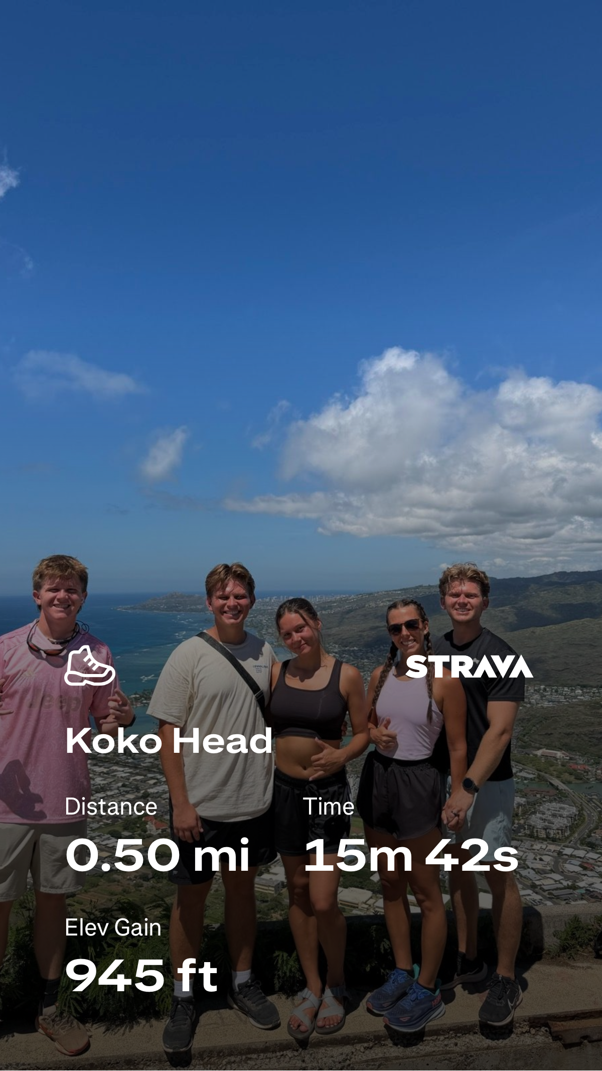
Koko Head is short enough to fit into a Honolulu morning and steep enough to feel like a concentrated mountain workout. The historic Koko Crater Tramway climbs almost straight up the crater flank on old railway ties. On Global Summit Guide’s 2026 visit, Dawson Ludlow recorded the uphill in 15:42 on Strava—0.50 mile with 945 feet of gain. That is a performance effort, not the pace most visitors should try to match.
Is the Koko Head Hike Worth It?
Yes—if you want a short, very steep Oahu summit workout with a huge view payoff. The Koko Crater Tramway is not a long wilderness hike. Its appeal is the opposite: the route wastes almost no distance. Once the railway ties begin, you climb directly toward the rim, gaining roughly a thousand vertical feet in a compact line.
The route is technically simple compared with exposed ridge hikes elsewhere on Oahu, but the physical demand is real. Irregular ties, tropical sun and a steep descent make pacing more important than the mileage suggests. If you are visiting primarily for scenery, move steadily and save enough legs for the descent. If you use mountains as fitness tests, Koko Head is one of the clearest uphill benchmarks on the island.
Dawson’s Koko Head Ascent: 15 Minutes, 42 Seconds
The most useful original data on this page is simple: we actually climbed it. Dawson’s Strava screenshot records the steep uphill effort as 0.50 mile, 945 feet of elevation gain and 15:42 elapsed time.
Those numbers explain Koko Head better than the word “stairs.” Half a mile with nearly 1,000 feet of climbing is brutally efficient. The climb does not give you long flat sections to reset your breathing. You keep stepping upward until the summit structures and coastal panorama finally replace the railway line in front of you.
Why our Strava numbers differ from published route figures: GPS distance and gain depend on exactly where an activity starts and stops, device smoothing and the geometry of a very steep route. The Kokonut Koalition describes the tramway as about 0.8 mile with roughly 1,100 feet of gain. We use Dawson’s screenshot only for his recorded uphill effort, not to redefine the official/public route.
A Straight-Line Climb With Almost No Wasted Motion
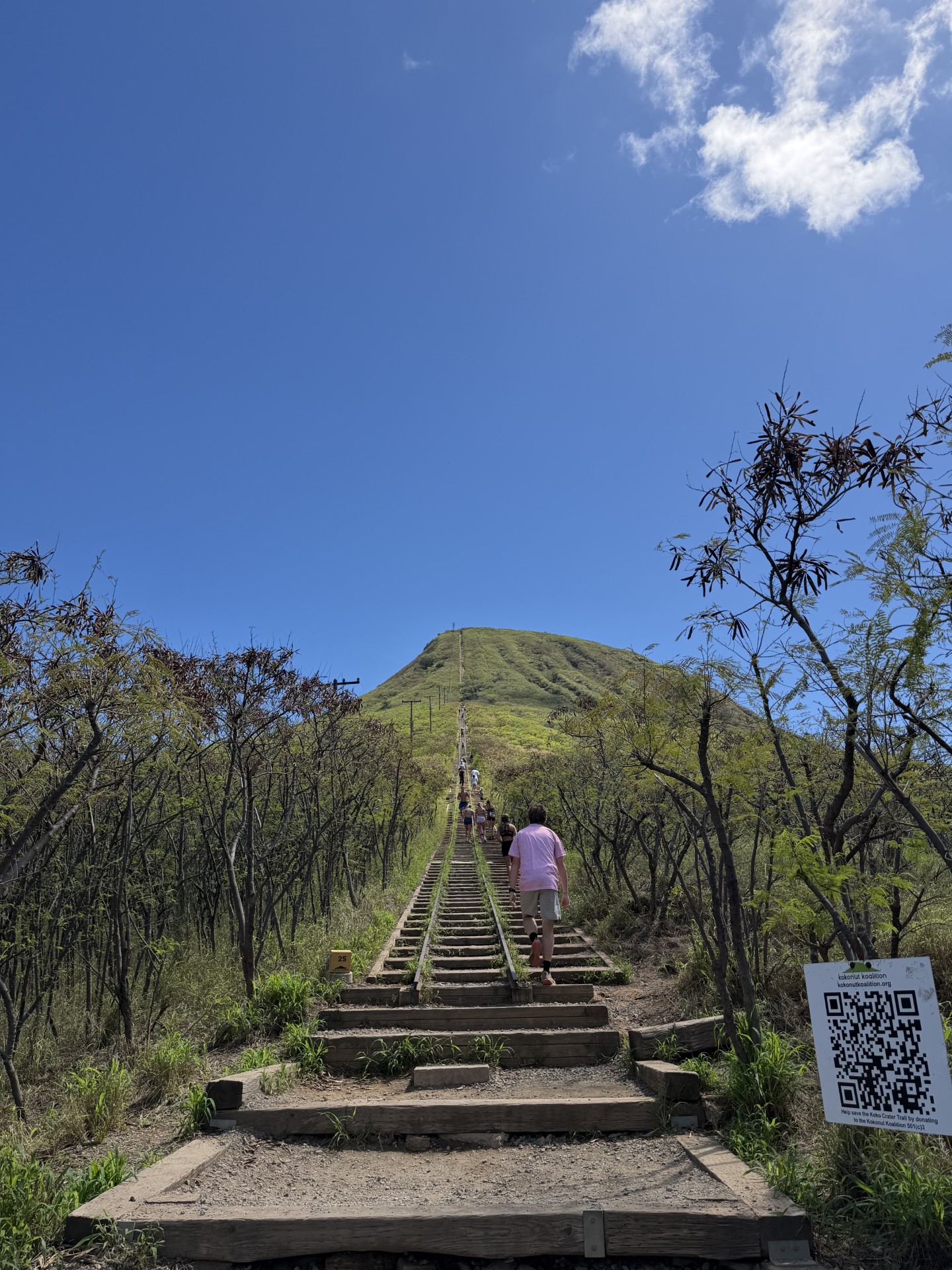
The trail is famous because the route profile is obvious from the bottom: the old tramway rises directly toward the crater rim.
Walk From the District Park to the Railway
From the Koko Head District Park area, follow the obvious approach toward the base of the tramway. The mountain is directly ahead and the line of ties is visible climbing the slope.
Find a Sustainable Rhythm Early
The lower ties make it tempting to start too fast. The grade keeps steepening, so an early red-line effort can make the upper section unnecessarily difficult.
Irregular Ties Demand Attention
The railway ties are not uniform gym stairs. Step height, spacing and surface vary. Keep your eyes on foot placement even when you are tired or distracted by the views.
The Steepness Is the Whole Point
Near the top, the climb feels compressed: lungs, legs and heat all arrive at once. Maintain your own pace rather than matching locals who may use Koko Head as a repeat training route.
Step Off the Line and Take In Hawaii Kai
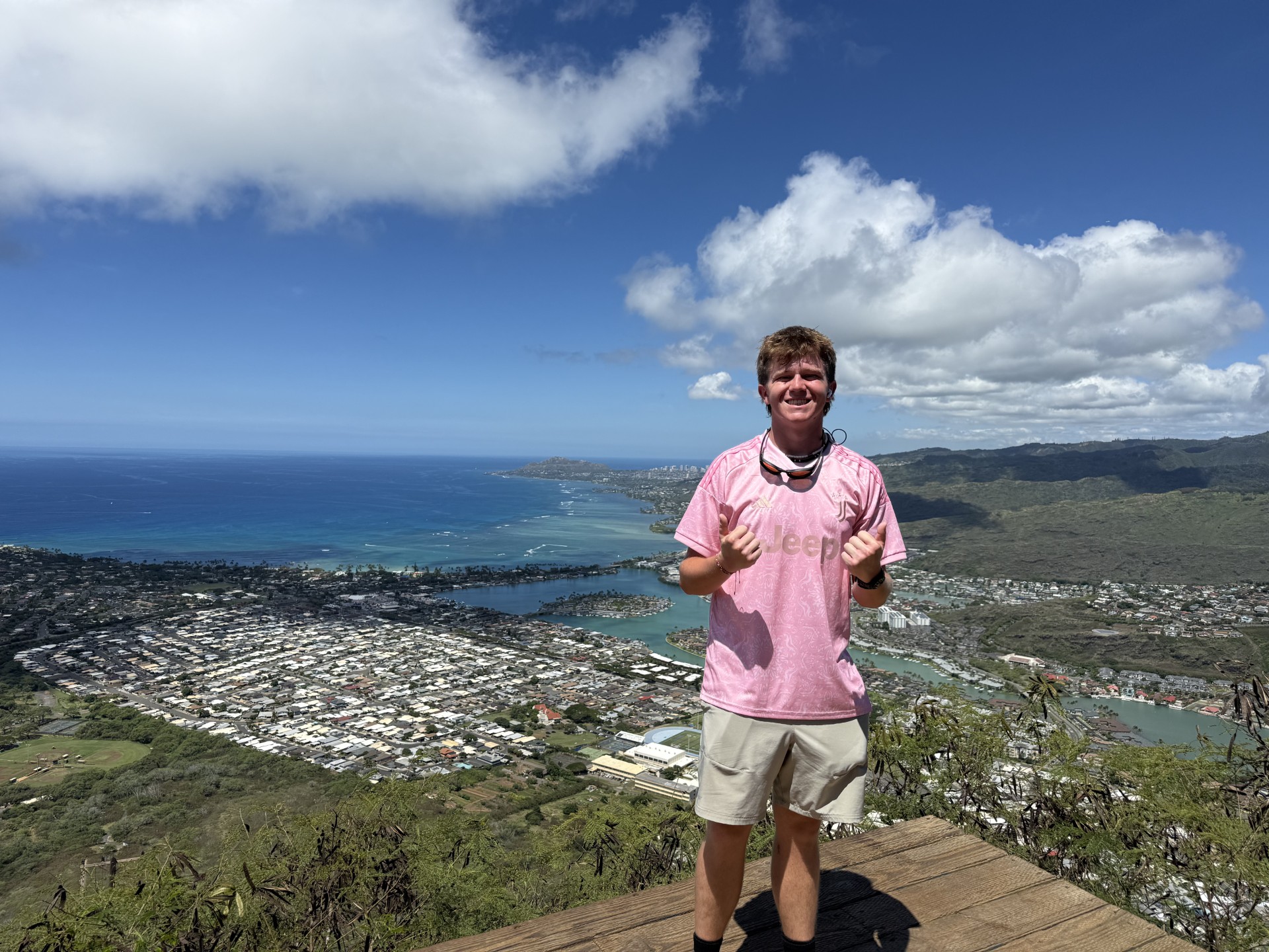
The summit area opens onto broad views over Hawaii Kai, Maunalua Bay, the Pacific and the surrounding crater landscape. Old military structures remain part of the summit environment.
Save Enough Control for the Way Down
The descent is not an afterthought. Fatigued legs, high steps and awkward spacing can make downward travel feel more technical than the ascent. Do not sprint the descent unless that is a movement pattern you already train.
The Staircase Is the Trail.
There is no long approach hiding the vertical. The historic tramway points almost straight at the summit, which is why Koko Head works equally well as a tourist hike, a leg-burning workout and a simple benchmark for uphill fitness.
Plan Around Heat Before You Plan Around Speed
Koko Head is easy to fit into an Oahu itinerary, but its exposed slope makes time of day matter.
| Planning question | What to know | GSG recommendation |
|---|---|---|
| Where do I park? | Koko Head District Park is the normal access area for the tramway. | Use designated park parking and avoid pushing parking impacts into nearby residential streets. |
| How early can I drive in? | Honolulu DPR says the time-activated vehicular gate follows established park closure hours of 11 p.m.–4 a.m. | Verify current gate/access information if planning a pre-dawn start. |
| Best time of day? | The slope is open and sun-exposed. | Early morning is usually the most comfortable choice; avoid building a heat-of-day fitness test into a vacation. |
| Water? | The climb is short but very intense and exposed. | Arrive hydrated and carry water rather than assuming short distance means low heat stress. |
| Footwear? | Wooden ties, dirt, uneven steps and a steep descent. | Use secure athletic or hiking footwear with reliable traction. |
Technically Simple. Cardiovascularly Unforgiving.
Koko Head is a useful reminder that “short” and “easy” are not synonyms.
High for the Distance
The vertical is compressed into a short climb. If you are accustomed to flat walking but not stairs, the route may feel far harder than its mileage suggests.
Low, but Footwork Still Matters
No mountaineering technique is required on the standard tramway line, but irregular ties and the steep descent reward deliberate steps.
Open and Sun-Exposed
The route offers little natural shade once you are committed to the staircase. Heat can turn a manageable climb into a poor decision quickly.
Do Not Underestimate the Descent
Falls and medical incidents happen here. HFD has repeatedly responded to injuries and hikers unable to continue. Carry enough reserve to descend under control.
Why the Summit Feels Bigger Than a 15-Minute Fitness Test
Dawson’s ascent was quick; the reason to linger is the landscape.
Hawaii Kai and Maunalua Bay
The urban shoreline, marina and blue Pacific spread immediately below the summit. The steepness of the climb becomes obvious when you look back down at how quickly the city dropped away.
Koko Crater From Above
The rim perspective turns a workout into a volcanic-landscape experience. The crater form, dry vegetation and surrounding coastal terrain read much more clearly from the summit.
A WWII Tramway Became One of Oahu’s Most Famous Workouts
The route exists because this was infrastructure before it was recreation.
The tramway was constructed by the U.S. military during World War II to move cargo and personnel to a summit radar station. Honolulu’s 2021 account of the restoration says the system was built in 1942, the station was deactivated in 1947, and the remaining structures and tramway were transferred to the City and County of Honolulu in 1966.
Decades of recreational use eventually wore the route down. The Kokonut Koalition organized a major volunteer rehabilitation with City support, replacing and repairing hundreds of ties. The result is unusual: a historic military utility line preserved through community labor and now used daily as a public fitness climb.
Koko Head Is a Great Benchmark—If You Use It Correctly
The clean vertical profile makes progress easy to feel without pretending a staircase is the same as a big mountain.
Uphill Economy
A steady ascent teaches rhythm: step height, breathing, cadence and how quickly you recover when the gradient never disappears.
Leg Endurance
The stairs load quads, glutes and calves repeatedly. The descent adds eccentric loading that can expose weak downhill control.
Mountain Endurance
One short hard climb does not reproduce hours of trail time, pack carry, altitude, weather or technical terrain. Koko Head is a component, not a complete training plan.
8-Week First Summit Training Plan
Use stairs as one training tool inside a broader program that also builds hiking volume, recovery and real elevation gain.
See the training progression →Where Koko Head Fits in a Hawaii Mountain Trip
This is an Oahu fitness summit, not Hawaii’s biggest mountain objective.
Global Summit Guide’s Best Mountains to Climb in Hawaii guide places Koko Head among the state’s accessible day-hike summits. That is the right role for it. Koko Head delivers steepness and views without altitude, glacier travel or a long backcountry commitment. If you are building toward bigger objectives, use it as a leg-and-lung test—not as evidence that you are automatically ready for Mauna Kea, Mauna Loa or technical ridges.
For a hot, exposed climb like this, combine route planning with the broader Mountain Weather framework and basic hydration/gear preparation rather than relying only on the forecast icon.
Use Koko Head as a Checkpoint, Not a Finish Line.
If Koko Head is part of a larger hiking progression, save the climb in My Climb and record what mattered: your uphill time, how your breathing felt, how the heat affected you, and whether your legs stayed controlled on the descent. Those observations are more useful than simply checking off the summit.
What Comes From Dawson—and What Comes From Official Sources
We separate field evidence from public route facts so a fast personal effort is not mistaken for a universal trail benchmark.
Dawson’s 2026 Ascent
- Strava screenshot: 0.50 mi
- Elapsed ascent: 15m 42s
- Recorded elevation gain: 945 ft
- GSG-hosted summit and route photography on this page
These are Dawson’s recorded activity values and should not be substituted for a surveyed route measurement.
Access, History & Safety
Koko Head Hiking FAQ
Use these answers for trip planning, then verify current access before departure.
How many stairs are on the Koko Head hike?
The most widely used count is 1,048 railway ties or steps. Honolulu used the 1,048 figure in its description of the major volunteer repair effort, while the Kokonut Koalition describes the historic tramway as having approximately 1,055 cross-ties. Either way, this is roughly a thousand steep, irregular steps—not a normal staircase.
How long did Dawson Ludlow take to climb Koko Head?
Dawson’s Strava screenshot records 15 minutes 42 seconds for 0.50 mile and 945 feet of elevation gain. That is his personal recorded uphill effort and is not presented as a normal visitor time or a speed recommendation.
How difficult is Koko Head?
Technically, the standard tramway climb is straightforward. Physically, it is demanding because the vertical gain is compressed into a short distance with little shade. The steep descent on tired legs is also part of the difficulty.
Is Koko Head good for beginners?
A fit beginner who is comfortable on steep stairs can consider it with conservative pacing, water and an early start. Someone with limited stair fitness, balance concerns or poor heat tolerance should choose a gentler Oahu hike first.
What time should I hike Koko Head?
Early morning is generally the better planning choice because the route is highly exposed to sun. Honolulu DPR says the district park vehicular gate follows established closure hours of 11 p.m. to 4 a.m. Verify current access before a pre-dawn start.
Is Koko Head the same as Koko Crater?
The names are often mixed in visitor usage. “Koko Head hike” and “Koko Head stairs” commonly refer to the historic Koko Crater Tramway, which climbs the crater rim/summit area of Kohelepelepe.
Short Hike. Serious Vertical. Huge Oahu View.
Koko Head earns its reputation because it strips a summit climb down to the essentials: climb, breathe, keep stepping, then look back at how quickly the island fell away below you. Dawson’s 15:42 ascent shows how fast the route can be moved by a strong athlete. Most visitors should take the opposite lesson—respect the grade, manage the heat, and arrive at the summit with enough control left for the descent.
Koko Head: More Places We Have Climbed
From a fast Oahu ascent to long summit days in Utah and beyond, continue through our firsthand field reports.
Was this helpful?
Global Summit Guide is an independent mountaineering resource founded in 2026. The team combines first-hand trekking and climbing experience with in-depth research and professional health and nutrition review to help climbers choose objectives, prepare properly, and stay safe.
Health, altitude, and nutrition content is reviewed by Taylor Ludlow (Registered Nurse) and Brigg Hoopes (Nutritionist).
What We Don't Know Yet
Mountain information changes quickly. This box explains the limits of what this page can responsibly promise.
- Visa, passport, vaccination, border, insurance, and local transportation rules may change before your trip.
- Route conditions, snowpack, closures, and weather can change quickly after this page is updated.
- Permit rules, fees, quotas, and reservation windows may change between review cycles.
- Operator availability, pricing, guide ratios, and cancellation terms can change by season.
- Your fitness, altitude response, risk tolerance, and experience level may change what is safe or realistic.
Verify current conditions with official land managers, guide services, local forecasts, and current route reports before booking or climbing.
Mountaineering, rock and ice climbing, glacier travel, and high-altitude activity are inherently dangerous and can result in serious injury or death. The information on Global Summit Guide is provided for general informational and educational purposes only and is not a substitute for professional instruction, qualified guiding, proper equipment, or your own judgment and experience.
Route conditions, weather, snowpack, permits, regulations, and hazards change constantly and may differ from what is described here. Details may be incomplete, out of date, or contain errors. Always verify current information with local authorities, certified guides, and official sources before making any decision in the mountains.
Nothing on this site is medical, legal, or financial advice. Our fitness, acclimatization, altitude, and nutrition content is general in nature; consult a qualified physician before beginning any strenuous exercise program or exposing yourself to high altitude.
You are solely responsible for your own safety and decisions. To the fullest extent permitted by law, Global Summit Guide and its team accept no liability for any loss, injury, damage, or expense arising from use of, or reliance on, this information. By using this site you acknowledge these risks and accept these terms.
Some links on this site may be affiliate links. If you buy through them we may earn a small commission at no extra cost to you; this never affects our recommendations.
Global Summit Guide recommendation path
Next Best Mountain to Research
Use these recommendations to continue the right planning path instead of stopping on one page.
Use current permit, weather, route, and operator information before booking or climbing.
Search Flights, Hotels & Rental Cars
Have the mountain or destination picked? Use Expedia to compare the flights, lodging and rental cars that fit your actual trip dates. For mountain travel, consider arriving early enough for delays and adding a buffer night after the climb before a fixed flight home.
Compare current flight, hotel and car options.
Affiliate disclosure: Global Summit Guide may earn a commission if you book through this link, at no additional cost to you.