
Weisshorn routes guide: east ridge, north-north-west ridge, and schaligrat
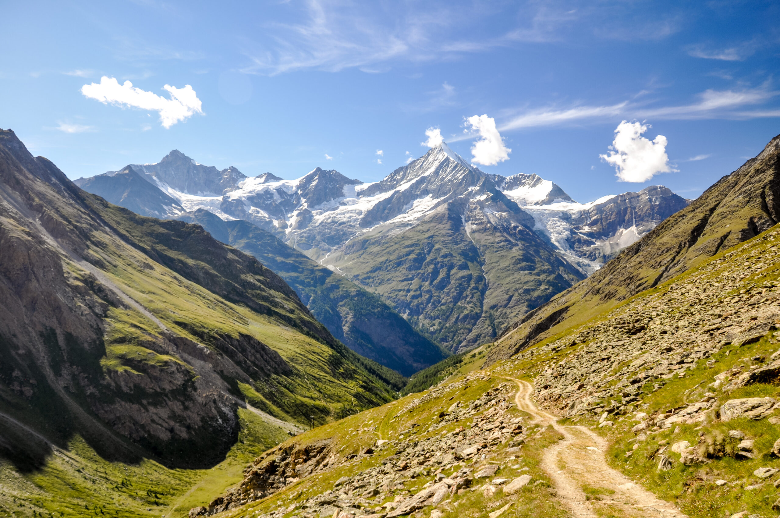
The Weisshorn rises as a striking pyramid above Randa in Switzerland’s Canton Valais, the ninth-tallest of all Alpine four-thousanders and considered by many alpinists the most beautiful mountain in the entire range. Three prominent ridges — the East, the North-North-West, and the Schaligrat — diverge in star-shaped symmetry from the 4,505-meter summit, and every route to the top is a serious alpine undertaking. The Weisshorn is widely considered to have the second-hardest normal route of any Swiss 4,000-meter peak, with only the Lenzspitze normal route being harder.
This guide covers all three classic ridges in route-by-route detail, with verified grades, approach huts, summit day timings, and what to expect on each line. We open with the East Ridge — the normal route since John Tyndall’s first ascent on 19 August 1861 — followed by the elegant North-North-West Ridge via the Bishorn from Zinal, and finally the harder Schaligrat south-west ridge first climbed in 1877. Each route delivers a different character of climbing, but all three demand stamina, technical competence on mixed terrain, and a partnership with a qualified mountain guide for most parties.
Route comparison at a glance
Before diving into route-by-route detail, here is the comparison table that gets used most often in trip planning. All grades use the standard French alpine system (F → PD → AD → D → TD → ED) cross-referenced with UIAA technical rock grades on the crux pitches.
| Route | Grade | Approach hut | Crux feature | Round trip from hut |
|---|---|---|---|---|
| East Ridge (Ostgrat) — Normal Route | AD+ / III-IV | Weisshorn Hut, 2,932 m | Lochmatter Tower (Lochmatterturm) | 10-12 hours |
| North-North-West Ridge (via Bishorn) | AD+ / III+ | Cabane de Tracuit, 3,256 m | Grand Gendarme, 4,329 m | 12-14 hours |
| Schaligrat (South-West Ridge) | D / IV | Schalijoch bivouac, 3,786 m | Sustained ridge climbing | 10-12 hours |
How to read this table
The Weisshorn has no easy route — even the easiest line (East Ridge) is graded AD+ with sustained III-IV climbing and is considerably more difficult than the normal routes on most other Alpine 4,000-meter peaks. Climbers without solid Grade III rock experience on alpine terrain, glacier travel competence, and the fitness for 1,600 m of vertical gain followed by a long descent should look at the Bishorn (4,151 m) — Weisshorn’s neighbour on the NNW ridge — as a more reasonable first objective in the area.
1. East Ridge — the normal route
The East Ridge has been the standard line on the Weisshorn for more than 160 years. John Tyndall, the Irish physicist, climbed it with guides Johann Joseph Bennen and Ulrich Wenger on 19 August 1861, starting from the village of Randa and reaching the summit after roughly twenty hours of nearly continuous work. The route they pioneered is the route guided parties still climb today — though now from the comfortable Weisshorn Hut at 2,932 m rather than a bivouac on the open mountain.
East Ridge (Ostgrat)
AD+ · III-IVHut approach (Day 1)
The journey starts in the village of Randa in the Mattertal, the same valley as Zermatt, reachable by train from Visp. From Randa station, a well-marked but steep alpine path climbs roughly 1,500 m through forest and meadow to the Weisshorn Hut at 2,932 m, the SAC Basel section hut that has been the base for all standard ascents since the late nineteenth century. The approach takes most parties 4-5 hours and is itself a substantial outing. Walk in light — your guide will brief you at the hut around 18:00 and dinner is served early so climbers can be in bed by 20:30.
Summit day (Day 2)
An 03:00 start by headlamp is standard. From the hut a clear trail leads down briefly and then onto the Schaligletscher (Schali Glacier), which is crossed by rope team to the base of the rocks below the east ridge. A short UIAA II rock band — the Wasserloch (Waterhole) — gives access to the firn shoulder and the famous Frühstücksplatz (“breakfast spot”) at 3,914 m, traditionally reached at first light. From here the real climbing begins.
The east ridge proper is sharp, exposed, and continuously interesting. Mixed rock and snow leads up the firn shoulder toward the day’s crux: the Lochmatter Tower (Lochmatterturm), a rock step with ledges in the UIAA III-IV range. With fresh snow this becomes a tricky proposition — climbing with crampons over snow-covered rocks requires precise footwork and steady nerve. Above the Lochmatter, the ridge eases briefly, then steepens again for the final section. The last 500 m of vertical gain is a striking 45-degree snow and ice ridge that narrows to a knife-edge before the summit cap, where a few small rock steps lead to the highest point at 4,505 m.
The descent retraces the ascent line. The Lochmatter Tower involves at least one short rappel for most parties. Total time from the Weisshorn Hut to the summit averages 6-7 hours for fit guided parties, with the descent back to the hut taking another 5 hours — a 10-12 hour day at altitude on technical terrain.
Why this route
- Historic line — the original 1861 Tyndall route, still the standard today
- Continuously interesting climbing rather than long boring sections
- Best hut on the mountain for accommodation and approach logistics
- Train access to Randa from anywhere in Switzerland via Visp
Why not
- 1,600 m vertical gain on summit day is brutal — many parties find the descent harder than the ascent
- Lochmatter Tower becomes serious with any fresh snow or verglas
- Long, sustained climbing means no quick retreat option in deteriorating weather
Editor’s note
If you read English-language climbing forums about the Weisshorn (UKClimbing, UKHillwalking) you’ll see repeated themes: “Bonne descente!” jokes about the brutal descent back to Randa, comments about how the route “was ace, continuously interesting”, and confessions of parties “shattered” at the hut by evening. The East Ridge is technically AD+, but it climbs like a serious commitment. Plan for it as such.
2. North-North-West Ridge — the elegant alternative
The North-North-West Ridge — sometimes simply called the North Ridge in modern English-language sources — is the quality alternative to the standard East Ridge. It starts from the brand-new Cabane de Tracuit at 3,256 m above Zinal in Val d’Anniviers, traverses the easy summit of the Bishorn at 4,151 m, then drops to the Weisshornjoch and tackles the proper Weisshorn pyramid via its northern arête. Many experienced alpinists believe this is the finest mixed ridge in Switzerland.
North-North-West Ridge (via Bishorn)
AD+ · III+Hut approach (Day 1)
The approach starts in Zinal, the climbing village at the head of Val d’Anniviers. From Zinal a well-marked alpine trail climbs roughly 4 hours to the rebuilt Cabane de Tracuit at 3,256 m, a brand-new SAC hut with spectacular views and good food. Unlike the Weisshorn Hut, Tracuit hosts a mixed clientele including families and hikers attempting the Bishorn — the Weisshorn climbers are typically the “serious” minority in the dining room. The hut is also the base for the popular Bishorn climb, which is one of the easiest Alpine 4,000-meter peaks and makes a good warm-up day if the schedule allows.
Summit day (Day 2)
A 02:00 wake is standard for the NNW Ridge — the route is longer than the East Ridge. From Tracuit a glacier crossing leads to the NW slope of Pointe Burnaby (4,133 m) and then up the short east ridge of the Bishorn. The Bishorn summit at 4,151 m is reached about 3 hours from the hut. Most parties claim the Bishorn as a bonus summit, then descend SSW to the Weisshornjoch at 4,060 m, where the real climbing begins.
The NNW ridge climbs easily over snow and then mixed terrain to Point 4,202. Two short downclimbs or rappels (the second on the east flank, UIAA III+) drop into a notch, then more mixed climbing leads to a steep slab tower — climbed direct at UIAA III or traversed underneath on the east flank. The airy crest continues to the notch before the largest tower on the entire mountain: the Grand Gendarme.
The Grand Gendarme sits at 4,329 m and is the iconic feature of this route. From the notch below, a 5-meter traverse on the east flank leads to an obvious steep corner and chimney above — about 35 m of UIAA III+ climbing, bolted for protection. Three bolted abseil points allow safe descent. Above the Gendarme the route follows steeper firn ridges interspersed with rocky gendarmes (“rocky pinnacles that guard the summit and which must be climbed up and over”) to the final summit cap. The exposure on the upper snow ridges is dramatic — “miles of exposure” on the knife-edge sections before the top.
Why this route
- Bishorn bonus summit — bag a second 4,000-meter peak on the way
- Best mixed-ridge climbing in the Swiss Alps according to many experienced alpinists
- Grand Gendarme with its bolted line is one of the great features of the Pennine Alps
- Quieter than the East Ridge — Tracuit climbers are a small minority of the hut population
Why not
- Longer summit day — 12-14 hours vs 10-12 for the East Ridge
- More committed — once past the Weisshornjoch, retreat is difficult
- Cold — the upper Bishorn is often bitterly cold even on good summer days; bring an additional down jacket
Many parties combine these
A classic traverse of the Weisshorn involves climbing one ridge and descending the other. The most popular combination is up the East Ridge and down the NNW Ridge to Tracuit, or vice versa. Both ridges are roughly the same difficulty, but the descent of the NNW Ridge — with its bolted rappels on the Grand Gendarme — is often considered the easier of the two descents, especially for tired parties. A north-to-south traverse (up the Schaligrat or NNW, down the East Ridge to Randa) is also possible but requires substantial logistical planning.
3. Schaligrat — the harder south-west ridge
The Schaligrat is the third classic ridge on the Weisshorn and a step up in commitment and technical demand from the two AD+ normal routes. It was opened in 1877 by W. E. Davidson, J. W. Hartley, H. S. Hoare with guides P. Rubi, J. Juan and A. Pollinger, who climbed the lower south-east face above the Schali Glacier and gained the south-west ridge before continuing to the summit. Today the standard line approaches the Schaligrat from the south via the Schalijoch bivouac at 3,786 m.
Schaligrat (South-West Ridge)
D · IVApproach
The Schaligrat is one of the more committing classic ridges in the Swiss Alps because even reaching the start is a serious undertaking. The standard approach from the Mountet Hut crosses the Arête du Blanc and traverses the Schalihorn (3,975 m) at ZS+ / AD+ grade III/IV — sometimes on poor rock — to reach the Schalijoch bivouac at 3,786 m. This is described by experienced parties as “a sort of test: those who have no difficulties with Schalihorn traverse will have no real issue on the Schaligrat itself.” Some parties bivouac at the Schalijoch shelter, others push through to the summit and descend via the East Ridge in a single very long day.
Climbing the ridge
From the Schalijoch the Schaligrat is a sustained rock climb on generally good rock — better quality than the connecting Schalihorn. The grade is D with sustained UIAA IV climbing in places and a few short pitches at the technical crux. Recent UKC trip reports describe the rock as “solid on the ridge, less so if traversing below the crest” — staying on or near the ridge crest is the standard advice. The final sections meet the summit ridge of the Weisshorn proper, where the East Ridge upper section is joined for the last few hundred meters to the 4,505 m summit.
Descent is almost always made via the East Ridge to the Weisshorn Hut and then down to Randa — making the Schaligrat ascent effectively a south-to-north traverse of the Weisshorn, one of the great outings in the Pennine Alps.
Who this is for
- Experienced alpinists comfortable with sustained UIAA IV climbing on alpine rock
- Parties with prior experience on the East Ridge or similar AD+/D Alpine ridges
- Climbers seeking the full traverse of the Weisshorn from south to north
- Bivouac-comfortable teams with experience on basic bivvy shelters at altitude
The other faces — for context
The Weisshorn’s three principal ridges divide the mountain into three faces, each with its own character. The faces are mentioned here for context — none of them is a sensible alternative to the three ridges for the vast majority of climbers, but understanding the geography helps the route descriptions above make more sense.
North-east face (Bisgletscher side)
The north-east face rises above the Bisgletscher (Bis Glacier) and is the snow-covered face that dominates the view from Randa — the face that gave the mountain its name (“Weiss” = white). It is mostly long, extremely steep slopes of snow and ice. The face has seen significant ascents in the past but is no longer a standard climbing objective due to rockfall and changing glacial conditions. In April and May 1991, two consecutive major rockslides occurred from a cliff above Randa on this side of the mountain.
South-east face (Schaligletscher side)
The south-east face lies between the East and South-West ridges, rising above the Schaligletscher (Schali Glacier). The lower sections were the start of the Davidson-Hartley-Hoare 1877 ascent before they gained the Schaligrat proper. The face has seen tragic history — Englishman John Garforth Cockin was killed making a solo attempt on the south-east face in the late nineteenth century.
West face (Anniviers side)
The west face rises above the Glacier du Weisshorn and Moming Glacier and presents “one gigantic face of rocky precipice” — two kilometers along the base, mostly rock, dominating the view from Val de Zinal. It is the largest of the three Weisshorn faces and has seen extreme modern alpine routes, but is not a standard climbing objective. The SAC route portal describes it as a defining landmark of the mountain visible from across Val d’Anniviers.
Important historical context
The Weisshorn has a serious accident history that climbers should respect. In 1925, Eleonore Noll-Hasenclever was killed by an avalanche on the north-east face. John Garforth Cockin was killed solo on the south-east face. In 1991 the major rockslides above Randa occurred on the east side. In 1983 an Alouette III helicopter from Air Zermatt crashed on the Schali Glacier during a night rescue. The mountain is not the Matterhorn — there is no cable, no fixed rope infrastructure, and no quick descent option. Hire an IFMGA-certified mountain guide unless you have substantial prior experience on Alpine ridges of this grade.
Choosing your route
For most climbers, the decision framework is straightforward:
- First Weisshorn ascent, standard objective: East Ridge from the Weisshorn Hut. The historic line, the most accommodating hut, the most documented route information, and the easiest logistics from anywhere in Switzerland via train to Randa.
- Second Weisshorn ascent or experienced alpinist seeking the best climbing: NNW Ridge from Tracuit. The Bishorn bonus, the iconic Grand Gendarme, and what many consider the finest mixed ridge in the Swiss Alps.
- Strong alpinist seeking a south-north traverse or harder grade: Schaligrat up, East Ridge down. The classic Weisshorn traverse, with sustained D-grade climbing and serious commitment from the Schalijoch onward.
- Combined Weisshorn-Bishorn outing: NNW Ridge up to the summit and down — the natural traverse line that bags both 4,000-meter peaks.
Whichever line you choose, the Weisshorn rewards the commitment with a summit experience that few Alpine peaks can match. From the top, the 360-degree panorama opens to the Dom, the Täschhorn, the Dent Blanche, the Zinalrothorn, and on a clear day all the way to Mont Blanc — and Zermatters describes the view as “an unrivalled 360° panorama of the Mischabel group.” It is, by common consent, one of the great summits in the Alps.
Other parts of the Weisshorn guide
Routes is one of six topics covered in the full Weisshorn climbing guide. Each sub-guide goes deep on one aspect of the climb.
Routes Guide
East Ridge, NNW Ridge via Bishorn, and Schaligrat — all three classic ridges with grade comparisons and route-by-route breakdowns.
Gear List
Complete equipment list for the AD+ East Ridge — boots, hardware, rope, layering, and what the Weisshorn Hut does and does not provide.
Permits & Logistics
Coming soon — hut bookings, guide hiring, transport from Visp to Randa or Sierre to Zinal.
Training Plan
Coming soon — fitness and skills preparation for a 1,600 m AD+ alpine day on technical terrain.
Weather & Best Season
Coming soon — the mid-July to mid-September weather window, snow conditions, and Mattertal vs Anniviers forecasting.
Difficulty & Safety
Coming soon — why the Weisshorn ranks as the second-hardest 4,000er normal route in Switzerland, and what that means in practice.
Weisshorn routes — frequently asked questions
What is the normal route on the Weisshorn?
The normal route on the Weisshorn is the East Ridge (Ostgrat), graded AD+. It begins at the Weisshorn Hut at 2,932 m above Randa in the Mattertal and ascends the Schaligletscher to the Frühstücksplatz at 3,914 m, then follows the sharp east ridge with sustained Grade III-IV rock climbing over the Lochmatter Tower (Lochmatterturm) to the final snow ridge and 4,505-meter summit. The East Ridge was the line of the first ascent on 19 August 1861 by John Tyndall with guides Johann Joseph Bennen and Ulrich Wenger, and it remains the standard route today. The Weisshorn is widely considered to have the second-hardest normal route of any Swiss 4,000-meter peak — only the Lenzspitze normal route is harder.
How difficult is the Weisshorn East Ridge?
The Weisshorn East Ridge is graded AD+ (Assez Difficile, upper end) with sustained Grade III rock climbing on the ridge crest and a crux at the Lochmatter Tower involving UIAA III-IV climbing. The route involves the Schaligletscher glacier crossing, mixed terrain through the Wasserloch to the Frühstücksplatz at 3,914 m, rock and mixed climbing along the east ridge, and a final 45-degree snow and ice ridge to the summit. Total elevation gain from the Weisshorn Hut is approximately 1,600 m and the round trip from the hut takes 10-12 hours for fit parties. The ascent is widely considered more demanding than the Matterhorn Hörnli Ridge.
How long does it take to climb the Weisshorn?
A standard Weisshorn ascent takes two to three days. Day one is the approach from Randa to the Weisshorn Hut at 2,932 m, requiring 4-5 hours of climbing the steep alpine trail. Day two begins around 03:00 with the summit attempt via the East Ridge, requiring 6-7 hours to the summit and 5 hours to descend back to the Weisshorn Hut, for a total summit day of 10-12 hours. Most parties spend a second night at the hut before descending to Randa on day three, though strong teams may descend all the way to Randa on summit day. The Cabane de Tracuit approach for the NNW Ridge adds a similar two-day commitment from Zinal.
When is the best time to climb the Weisshorn?
The Weisshorn climbing season runs from mid-July to mid-September, with the most stable conditions typically in August and early September. Early July often has too much fresh snow on the ridge for safe progress, while late September brings the first autumn storms and shortened daylight. Within the season, stable high-pressure windows of 2-3 days are essential — the East Ridge is too long to retreat from in deteriorating weather. Recent fresh snow significantly increases difficulty since the rock-and-mixed terrain becomes verglas-coated. Guided ascents through Zermatters and similar operators typically run daily from mid-July to mid-September, conditions permitting.
What is the difference between the East Ridge and the North-North-West Ridge?
The East Ridge is the standard normal route, starting from the Weisshorn Hut at 2,932 m above Randa in the Mattertal. The North-North-West Ridge is a quality alternative starting from the Cabane de Tracuit at 3,256 m above Zinal in Val d’Anniviers, and it includes a traverse over the Bishorn summit at 4,151 m before tackling the main Weisshorn ridge. Both routes are graded AD+, but the NNW Ridge features the iconic Grand Gendarme at 4,329 m (climbed via a steep III+ corner and chimney with bolts) while the East Ridge features the Lochmatter Tower crux. Many experienced parties consider the NNW Ridge to have a better balance of elegant snow crests and fine rock scrambling, while the East Ridge has more sustained ridge climbing on solid rock.
How does the Weisshorn compare to the Matterhorn?
The Weisshorn at 4,505 m is higher than the Matterhorn at 4,478 m, and the normal route is widely considered more difficult and more committing than the Matterhorn Hörnli Ridge. The East Ridge involves 1,600 m of vertical gain and a 10-12 hour round trip from the hut, compared to the Matterhorn’s Hörnli Hut to summit gain of about 1,200 m. The Weisshorn sees far fewer climbers and has no fixed ropes, no cable-equipped sections, and far less infrastructure than the Matterhorn — many alpinists consider this a virtue, others a serious challenge. Zermatters describes the Weisshorn as “wild, elegant and challenging”, with a silhouette “almost more beautiful than that of the Matterhorn” but an ascent that is “longer, more alpine and quieter”.