
Climbing Thamserku: The Complete 2026 Khumbu Region Routes, NMA Permits & Hillary Schoolhouse Expedition First Ascent Guide
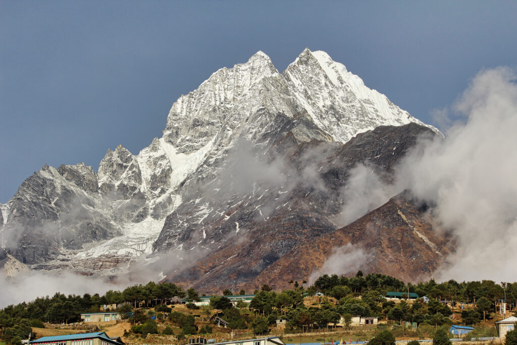
Thamserku rises to 6,608 m (21,680 ft) as one of the most visually prominent peaks of the Khumbu region in eastern Nepal. The mountain dominates the eastern horizon from Namche Bazaar, where every Everest Base Camp trekker sees its dramatic profile against the sky. Despite this fame as a visual icon of the Sherpa Khumbu, Thamserku has been climbed only six times in confirmed ascents — a striking contrast between visual prominence and actual summit traffic that distinguishes it from neighboring peaks like Ama Dablam or Island Peak.
The peak’s reputation for technical difficulty traces back to its 1964 first ascent. New Zealanders Lynn Crawford, Pete Farrell, John McKinnon, and Richard Stewart climbed Thamserku on November 4, 1964, as part of Edmund Hillary’s Himalayan Schoolhouse Expedition — the project that built the first schools in the Khumbu region. The summit team described the climbing as exceptionally difficult, comparing it directly to technical ascents in the Andes with steep flutings, mushrooms, and cornices throughout. The team used four camps, 1,200 m of fixed rope, and 30 m of rope ladder. Remarkably, the 1964 route has never been repeated in its entirety.
Thamserku connects to Kangtega (6,685 m) via a ridge running eastward, and sits just north of Kusum Kangguru (6,367 m). The three peaks together form one of the most aesthetic mountain groups in the Khumbu, though each is climbed independently. Thamserku is sometimes called Snow Saddle in reference to its dramatic saddle-shaped summit, though the more common Sherpa-language name dominates international use.
The 2014 first ascent of Thamserku’s southwest face — completed by Russian climbers Alexander Gukov and Alexey Lonchinskiy from April 27 to May 3 — added a new line to the peak’s small route catalog. The Russian team named the route Shy Girl and graded it Russian 6A/6B, measuring the face at 1,623 m and the total climbing distance at 1,900 m to the summit. The 2014 ascent confirmed that Thamserku remains an active first-ascent objective for elite alpine teams more than 50 years after the 1964 pioneering climb.
This complete 2026 guide covers verified route descriptions, current Nepal Mountaineering Association permit requirements, Sagarmatha National Park access rules, gear lists, hazard analysis, seasonal timing, cost tiers, and the full expedition history. Every detail reflects 2026 conditions confirmed through May 2026 via the Nepal Mountaineering Association, registered Nepali expedition operators, and the American Alpine Journal historical archives.
Live Thamserku Operations Center
Real-time location intelligence and Namche Bazaar region weather conditions
Thamserku stands as one of the most photographed yet least-climbed peaks in the Khumbu region of eastern Nepal. The dramatic pyramid rises to 6,608 meters east of Namche Bazaar, where every Everest Base Camp trekker sees its profile dominating the eastern horizon. Despite this visual prominence, only six confirmed ascents have been completed since the 1964 first climb.
The first ascent was made on November 4, 1964 by four New Zealanders — Lynn Crawford, Pete Farrell, John McKinnon, and Richard Stewart — climbing as part of Edmund Hillary’s Himalayan Schoolhouse Expedition. The team approached the south ridge from the basin below the southwest face, climbed a difficult couloir to reach the ridge crest, then followed the ridge a long distance to the summit. They compared the technical character of the climbing to Andean alpinism, with steep flutings, mushrooms, and cornices throughout. The 1964 route has never been repeated in its entirety.
Thamserku’s modest summit count reflects a genuine technical challenge that contrasts with the peak’s accessible Khumbu location. The mountain is rated as one of the most demanding 6,000 m climbs in the entire Everest region — significantly harder than commercial trekking peaks like Island Peak or Mera Peak, and comparable in technical difficulty to neighboring Ama Dablam despite Thamserku’s lower elevation and lower commercial profile.
The 2014 first ascent of the southwest face by Russian climbers Alexander Gukov and Alexey Lonchinskiy added a new line to Thamserku’s small route catalog. The Shy Girl route — climbed April 27 to May 3, 2014 — measured 1,623 m on the face with 1,900 m of total climbing distance to the summit. The Russian team graded the line at Russian 6A/6B. The 2014 ascent confirmed Thamserku as an active first-ascent objective for elite alpine teams more than half a century after the pioneering 1964 climb.
For climbers seeking a serious Khumbu objective beyond the commercial trekking peaks, Thamserku offers a distinctive combination of accessibility, technical demand, and historic significance. The peak shares the Everest Base Camp approach trail through Lukla and Namche Bazaar with thousands of trekkers each season, but the climbing itself remains the province of small expedition teams with genuine technical credentials.
The south ridge approach via the southwest face basin remains the standard route on Thamserku. While the exact 1964 first-ascent line has never been repeated, modern expeditions use the same general aspect and ridge with variations adapted to current conditions. The route accounts for four of the six confirmed Thamserku ascents and represents the established line for new attempts. The 2014 Russian first ascent of the southwest face proper added a separate elite alpine objective, but the south ridge variations remain the primary realistic path for international expeditions.
Thamserku is not appropriate as a first 6,000 m climb. All routes involve steep ice and mixed terrain with sustained technical climbing on cornices, mushrooms, and flutings. The 1964 first-ascent team’s direct comparison of the climbing to technical Andean routes is a strong indicator of the unusual character. Climbers should have prior Himalayan or Andean experience at 6,000 m plus solid alpine ice and mixed climbing skills before attempting Thamserku. Most experienced operators recommend prior Island Peak, Mera Peak, or Ama Dablam ascents as preparation. The peak is significantly more demanding than its 6,608 m elevation alone suggests.
This guide consolidates information from the Nepal Mountaineering Association (NMA), Nepal Ministry of Tourism, Sagarmatha National Park authorities, the American Alpine Journal’s detailed 2015 article by Lindsay Griffin documenting the 2014 Russian southwest face first ascent and reviewing the broader Thamserku climbing history, Wikipedia historical records, and active Nepali expedition operator information. Some sources differ on the exact summit elevation — Wikipedia cites 6,623 m, the 2015 AAJ article uses 6,618 m, and commercial operators predominantly use 6,608 m. This guide uses 6,608 m as the workbook standard while acknowledging the variants. Every elevation, route grade, cost figure, and permit requirement reflects 2026 conditions confirmed through May 2026.
At a Glance: Thamserku Essentials
Thamserku presents a distinctive technical challenge in an accessible Khumbu location. The following statistics summarize the key parameters every climber must understand before planning an expedition. Each figure below reflects 2026 conditions verified through the Nepal Mountaineering Association and active operators.
Eight Reasons Climbers Choose Thamserku
Thamserku holds a unique position as one of the most visually iconic but least-climbed peaks of the Khumbu. The reasons climbers target this peak combine technical challenge, historic significance, accessibility, and the satisfaction of attempting a peak that sees only a fraction of the traffic of more commercial Khumbu objectives. Each motivation carries an associated responsibility for safe execution at altitude.
The Most Photographed Khumbu Peak
Thamserku dominates the eastern horizon from Namche Bazaar and appears in countless photographs from the Everest Base Camp trail. Climbing the peak means standing on the summit of an image millions of trekkers have seen but few have actually climbed — a distinctive visual significance.
Only Six Confirmed Ascents
Despite the visual prominence, Thamserku has been climbed only six times. The rarity of summits creates a distinct experience compared to commercial 6,000 m trekking peaks. Climbers join a small group of alpinists who have successfully completed one of the Khumbu’s least-trafficked summits.
Hillary Schoolhouse Expedition Heritage
The 1964 first ascent took place during Edmund Hillary’s Himalayan Schoolhouse Expedition — the project that built the first schools in the Khumbu region. Climbing Thamserku connects you to a foundational chapter in Sherpa-international relations and the modern development of the Khumbu.
Andean-Style Technical Character
The 1964 first-ascent team specifically compared the climbing to technical Andean routes — steep flutings, mushrooms, and cornices throughout. Climbers seeking Andean-quality technical climbing in a Himalayan setting find Thamserku offers a rare combination that distinguishes it from typical Nepal commercial peaks.
Shared Approach with EBC Trail
The Thamserku approach uses the same Lukla, Phakding, and Namche Bazaar trail that every Everest Base Camp trekker walks. The shared infrastructure means logistics are reliable and predictable, while the climbing itself diverges from the commercial trekking traffic at Phunki Tanga.
Active First-Ascent Era
The 2014 Russian first ascent of the southwest face (Shy Girl, 1,623 m, Russian 6A/6B) demonstrated that Thamserku remains an active first-ascent objective. New line potential continues attracting elite alpine teams seeking technical challenges beyond the standard south ridge.
Pre-Ama Dablam Progression
Climbers building toward harder Khumbu objectives often target Thamserku as preparation for Ama Dablam or as a more technical alternative. The peak offers serious 6,000 m experience with technical character similar to Ama Dablam at a slightly higher elevation but with less commercial traffic.
Sherpa Cultural Setting
The approach through the heart of the Khumbu provides immersion in Sherpa culture, including stops at Namche Bazaar, the trading hub of the region. The peak’s local Sherpa context — including its connection to the Schoolhouse Expedition heritage — adds cultural depth beyond pure mountaineering.
Who Can Climb Thamserku
Thamserku requires solid 6,000 m climbing experience and substantial technical credentials. The standard south ridge route demands prior Himalayan or Andean peak experience, competent crampon and ice axe technique on steep terrain, comfort with cornices and mushrooms, fixed rope familiarity, and tolerance for sustained 6,000 m exposure. Climbers should have completed prior peaks such as Island Peak, Mera Peak, Ama Dablam, Aconcagua, or similar objectives before attempting Thamserku.
The standard route involves approximately 1,648 m of climbing from base camp to summit, distributed across multiple high camps. The 1964 first-ascent team used four camps, 1,200 m of fixed rope, and 30 m of rope ladder — a strong indicator of the route’s character. Modern expeditions follow similar logistics with experienced Sherpa support handling fixed-rope installation on the most technical sections.
The peak’s technical character — Andean-style flutings, mushrooms, and cornices — demands specific skills that go beyond general high-altitude mountaineering. Climbers comfortable with straightforward steep snow and ice may still find Thamserku challenging due to the unusual terrain features. Operators typically require demonstrated prior experience on technical 6,000 m peaks rather than just any 6,000 m experience.
For climbers building toward harder Himalayan objectives, Thamserku provides exceptional preparation for technical 7,000 m peaks or for technical 6,000 m peaks like Ama Dablam. The peak’s combination of accessible logistics with genuinely demanding climbing creates a productive learning environment for serious alpine progression. Many Thamserku summiteers progress to harder objectives within one or two subsequent seasons.
The 1964 first-ascent team’s description of Thamserku’s climbing character is instructive for modern climbers. They explicitly compared the technical climbing to Andean ascents — a comparison that distinguishes Thamserku from the standard Khumbu snow-and-ice character of peaks like Island Peak or Mera Peak. The Andean-style features mean that climbers with strong Aconcagua, Cordillera Blanca, or Patagonia credentials may find Thamserku more familiar in technical character than climbers transitioning from European Alps or Cascade Range backgrounds. The peak’s character has been confirmed by subsequent ascents and remains a defining attribute that operators reference during pre-trip briefings.
Thamserku in the Khumbu Context
Thamserku occupies a central position in the eastern Khumbu region, the most internationally famous mountaineering area in Nepal. The peak sits in the Mahalangur Himal subrange between Namche Bazaar to the west, the Imja Khola valley to the north, and the Hinku valley to the south. The mountain is connected by a ridge running eastward to Kangtega (6,685 m), and lies just north of Kusum Kangguru (6,367 m), forming a distinctive three-peak visual group when viewed from the south.
The Khumbu region as a whole hosts some of the most iconic mountaineering peaks in the world. Mount Everest (8,848 m) dominates the broader range, with Lhotse (8,516 m) and Cho Oyu (8,201 m) completing the 8,000 m group. Below the 8,000 m peaks, the region contains classic 6,000 m and 7,000 m objectives including Ama Dablam (6,812 m), Pumori (7,161 m), Nuptse (7,861 m), and numerous others. Most Khumbu peaks share base infrastructure including Lukla airport, Namche Bazaar, and the established lodge system.
For climbers planning regional progressions, Thamserku pairs naturally with several Khumbu peaks. Island Peak (6,189 m) provides accessible acclimatization. Mera Peak (6,476 m) offers a slightly higher acclimatization option. Ama Dablam (6,812 m) provides the natural technical progression after Thamserku success. Kangtega (6,685 m) — Thamserku’s ridge partner — offers an alternative Khumbu technical objective with similar logistics.
The Khumbu Region Companion Peaks
Thamserku shares the Khumbu region with several iconic climbing peaks. All six peaks below provide alternative or progression objectives accessible from the same Lukla-Namche approach infrastructure.
Thamserku History: From Hillary’s Schoolhouse Expedition to Modern Era
Thamserku’s climbing history is concentrated in the modern era, with the peak’s striking visual prominence taking longer to translate into actual climbing activity than for many lower-profile Himalayan summits. The 1964 first ascent took place during a transformative period in the Khumbu region, and the subsequent decades have seen unusually limited summit traffic despite Thamserku’s accessible Khumbu location.
Pre-1960s: Reconnaissance era
Early European and international visits to the Khumbu region focused primarily on Mount Everest and the 8,000 m peaks. Thamserku appeared in expedition photographs as a visual feature of the broader landscape but received limited specific climbing attention. The peak’s dramatic profile was well documented during the 1950s Everest expedition era, but no serious climbing attempts on Thamserku occurred during this period.
1964: Edmund Hillary’s Himalayan Schoolhouse Expedition
The 1964 Himalayan Schoolhouse Expedition was led by Sir Edmund Hillary in a project that combined mountaineering with humanitarian work building the first schools in the Khumbu region. The expedition’s primary purpose was establishing educational infrastructure for the Sherpa community, with climbing objectives as secondary goals. The Thamserku climbing team consisted of four New Zealanders: Lynn Crawford, Pete Farrell, John McKinnon, and Richard Stewart.
November 4, 1964: First ascent
The team completed the first ascent of Thamserku on November 4, 1964. They approached the south ridge from the basin below the southwest face, climbed a difficult couloir to reach the ridge crest, and then followed the ridge a long distance to the summit. The climbers found the climbing exceptionally difficult, describing it as much like a technical ascent in the Andes with steep flutings, mushrooms, and cornices. The team used four camps above base camp, 1,200 m of fixed rope, and 30 m of rope ladder to complete the climb. The Thamserku first ascent represented a significant technical achievement of the era and established the peak’s reputation as one of the more demanding climbs in the Khumbu region.
1970s-1980s: Limited subsequent activity
Through the 1970s and 1980s, Thamserku saw very limited climbing activity. The peak’s technical character meant it did not attract the same volume of commercial interest as Khumbu peaks like Island Peak and Mera Peak. Several attempts on the 1964 route encountered difficulties similar to those experienced by the first-ascent team, and the route was never repeated in its entirety despite multiple variations being climbed.
October 1986: Spanish southwest face attempt
A four-person Spanish team consisting of Jose Manuel Gonzales, Jose Luis Fernandez, Azucana Lopez, and Miguel Rodriguez attempted the southwest face of Thamserku in October 1986. The team first climbed to a bivouac at 5,700 m in the prominent central couloir. The next day they continued through a difficult rock barrier with grades from 65 degrees to 90 degrees to a second bivouac in an ice cave at 5,900 m. On the third day they reached 6,300 m, where they used hammocks to bivouac. The Spanish attempt did not complete the route but established the southwest face as a viable objective for future elite teams.
1990s-2000s: Continued limited traffic
Through the 1990s and 2000s, Thamserku continued to see limited expedition traffic relative to its visual prominence. The peak’s technical demands kept commercial expedition operators focused on easier Khumbu objectives. A small number of additional ascents were completed during this period, primarily from the south side following variations of the 1964 first-ascent line, though specific dates and team compositions vary in available documentation.
April 27 to May 3, 2014: Russian southwest face first ascent
Russian climbers Alexander Gukov and Alexey Lonchinskiy from St. Petersburg made the first ascent of Thamserku’s southwest face between April 27 and May 3, 2014. The team named the route Shy Girl and graded it Russian 6A/6B. The Russians measured the face at 1,623 m and the total climbing distance at 1,900 m to the summit. After reaching the summit, they descended the south ridge for seven rope lengths, bivouacked at 6,300 m for a seventh time, and then made 22 rappels down the southwest face to the glacier. The 2014 ascent represented the most significant Thamserku climb since the 1964 first ascent and added a major new line to the peak’s small route catalog.
Current 2026 status
Thamserku in 2026 remains one of the most visually prominent but least-climbed peaks in the Khumbu region. Total confirmed ascents number approximately six since 1964. The peak continues to attract elite alpine teams seeking technical challenges in an accessible Khumbu location. The shared approach infrastructure with the Everest Base Camp trail provides logistical convenience while the climbing itself remains the province of small expedition teams with genuine technical credentials. New route potential continues attracting first-ascent attempts, particularly on subsidiary aspects of the southwest face and the still-untouched east face.
Climbing Routes on Thamserku
Thamserku’s route catalog reflects the peak’s limited summit traffic. The south ridge — the 1964 first-ascent line and its variations — accounts for the majority of confirmed ascents. The southwest face has been climbed only once, by the 2014 Russian team. Other aspects of the peak have seen attempts but no confirmed completions. All routes require Nepal Mountaineering Association permits, Sagarmatha National Park permits, and registered Nepali operator coordination.
| Route | First Ascent | Grade | Length | Aspect | Frequency |
|---|---|---|---|---|---|
| South Ridge (Standard) | Crawford, Farrell, McKinnon, Stewart Nov 1964 | Expert Alpine | 1,648 m+ | South | Most ascents · 4 of 6 |
| SW Face — Shy Girl | Gukov, Lonchinskiy Apr-May 2014 | Russian 6A/6B | 1,623 m face / 1,900 m total | Southwest | One ascent |
| SW Face — Spanish attempt | Gonzales, Fernandez, Lopez, Rodriguez Oct 1986 | Technical mixed | Reached 6,300 m | Southwest | Unsuccessful |
| East Face | Unclimbed | Unknown | Unknown | East | First-ascent potential |
| Kangtega Ridge Traverse | Hypothetical | Extended Alpine | Multi-day | East ridge | Not completed |
South Ridge — Hillary Schoolhouse 1964 First Ascent Line
The south ridge route represents the standard approach on Thamserku and accounts for four of the six confirmed ascents. Climbers begin from Kathmandu with a flight to Lukla (2,800 m), then trek through Phakding to Namche Bazaar (3,440 m). After acclimatization at Namche, the trail continues to Phunki Tanga (3,250 m) where the Thamserku approach diverges from the standard Everest Base Camp trail. Base camp is established at approximately 4,960 m.
From base camp, the route ascends into the basin below the southwest face. Climbers then traverse to the south ridge via a difficult couloir — the same approach pioneered by the 1964 first-ascent team. The couloir climbing is technical with steep snow and ice, requiring competent crampon technique and confident ice tool placement. Once on the south ridge proper, the climb follows the ridge crest a long distance to the summit, traversing the characteristic Andean-style flutings, mushrooms, and cornices that defined the 1964 team’s experience.
The 1964 team used four camps above base camp, 1,200 m of fixed rope, and 30 m of rope ladder to complete the climb. Modern expeditions follow similar logistics with experienced Sherpa support handling fixed-rope installation on the most technical sections. The 1964 route in its exact form has never been repeated, with subsequent ascents following variations adapted to current snow and ice conditions.
The summit push from the highest camp typically takes 10-14 hours including descent. The climbing maintains technical character throughout, with no easy sections where parties can recover lost time. Hard turnaround times must be established and honored regardless of summit proximity given the route’s sustained difficulty and the long descent back to camp.
Southwest Face — Shy Girl (Gukov-Lonchinskiy 2014)
The southwest face was first climbed by Russian alpinists Alexander Gukov and Alexey Lonchinskiy from April 27 to May 3, 2014. The route — named Shy Girl by the climbers — measured 1,623 m on the face with 1,900 m of total climbing distance to the summit. The team graded the climb at Russian 6A/6B, a technical rating that places the route among the most demanding lines on any Khumbu peak.
The face is visible to Everest trekkers during their ascent to Namche Bazaar — making the route an obvious target despite the technical demands. The Russians’ choice to descend the south ridge for seven rope lengths, bivouac at 6,300 m, and then make 22 rappels down the southwest face represented an unusual descent strategy that distinguished the 2014 ascent from a pure up-and-down attempt.
Modern attempts on the southwest face remain very rare due to the sustained technical difficulty and the high commitment required. The route is appropriate only for elite alpine teams with significant Himalayan or Patagonian credentials. Specific repeat attempts since 2014 are limited, and the line remains primarily a historical achievement rather than an established climbing objective.
Southwest Face — Spanish 1986 Attempt
The 1986 Spanish team of Jose Manuel Gonzales, Jose Luis Fernandez, Azucana Lopez, and Miguel Rodriguez attempted the southwest face in October 1986. The team made significant progress, reaching 6,300 m before turning back. Their ascent established intelligence on the route that informed later attempts, particularly the 2014 Russian first ascent that finally completed the line.
The Spanish attempt is included here for historical completeness. The team’s approach — bivouac at 5,700 m in the central couloir, then a 65-90 degree rock barrier to an ice cave bivouac at 5,900 m, then hammock bivouac at 6,300 m — illustrated both the route’s character and the elite-level commitment required. The attempt represented one of the earliest serious efforts on the southwest face.
East Face and Subsidiary Aspects
Several aspects of Thamserku remain unclimbed or have seen only attempts. The east face presents particularly significant first-ascent potential, though access and route-finding complexity has limited interest from elite teams. Subsidiary lines on the south and southwest aspects also offer first-ascent possibilities for teams seeking new objectives.
The Kangtega ridge traverse — a hypothetical multi-day connection from Thamserku to Kangtega via the connecting east ridge — has been discussed but not completed. The traverse would represent one of the most committing alpine traverses in the Khumbu region and remains a future objective for elite teams. Such a project would require multiple bivouacs and exceptional commitment.
Thamserku Access & Permits 2026
Thamserku access requires multiple permits combining Nepal Mountaineering Association expedition permissions with Sagarmatha National Park forest department permits and local municipal access permits. The peak’s classification within the NMA permit structure determines specific fee schedules.
Thamserku permits require advance application 2-3 months before expedition departure. The NMA coordinates with Sagarmatha National Park authorities and the Khumbu Pasang Lhamu Rural Municipality for local permits. Registered Nepali operators handle the full permit coordination including Liaison Officer assignment. The climbing seasons run primarily April-May (pre-monsoon) and October-November (post-monsoon). Popular dates fill first as international teams compete for the limited expedition slots that the peak’s low summit traffic generates.
Required documentation for 2026
- NMA climbing permit: Nepal Mountaineering Association expedition permit specifying Thamserku
- Sagarmatha National Park permit: Forest department permit issued at park checkpoints
- Khumbu Pasang Lhamu Rural Municipality permit: Local government permit for the climbing region
- Liaison Officer: NMA-assigned officer accompanies all foreign expeditions
- Registered operator coordination: Mandatory for all expedition logistics
- High-altitude insurance: Mandatory minimum coverage including helicopter rescue
- Nepali visa: Tourist visa with extension for full expedition duration
- Medical certificate: Required from registered medical practitioner
- TIMS card: Trekkers’ Information Management System registration
2026 Permit cost breakdown
- NMA Peak Booking Fee: USD 750-1,500 per expedition team for foreign nationals depending on season
- Sagarmatha National Park entry fees: NPR 3,000 per climber (approximately USD 25)
- Khumbu local government permit: NPR 2,000 per climber (approximately USD 15)
- Liaison Officer fees: USD 1,200-1,800 plus equipment hire for full expedition duration
- Registered operator base fees: USD 8,000-22,000 per climber depending on services
- High-altitude insurance: USD 800-1,500 per climber minimum
- Garbage deposit: Refundable environmental compliance deposit
Access logistics from Kathmandu
Thamserku is accessible from Kathmandu via the standard Khumbu approach. Climbers fly from Kathmandu to Lukla (2,800 m) — typically a 30-minute scheduled flight on a small aircraft. From Lukla, the trail follows the classic Everest Base Camp route: Phakding (2,640 m) on day one, Namche Bazaar (3,440 m) on day two, acclimatization rest at Namche, then continue to Phunki Tanga (3,250 m). From Phunki Tanga, the Thamserku approach diverges from the EBC trail and reaches base camp at approximately 4,960 m. Total Kathmandu to base camp logistics take 6-8 days including acclimatization stops. The standard expedition runs 28-32 days from Kathmandu through climbing and return.
Thamserku Climbing Costs in 2026
Thamserku expedition costs vary based on team size and service level. Fully guided programs run USD 12,000-25,000 per person — comparable to other technical Khumbu 6,000 m peaks. The peak’s lower commercial volume relative to Island Peak or Ama Dablam means fewer expedition operators offer Thamserku programs, but those that do typically have specific Khumbu Sherpa support relationships. All costs reflect 2026 conditions verified through active Nepali operators.
Group Guided Thamserku Expedition (4-6 climbers)
The most affordable Thamserku expedition option involves group climbs with 4-6 climbers per registered Nepali operator. Costs include NMA permits, Liaison Officer fees, Sagarmatha National Park permits, registered operator services, climbing Sherpa support, fixed ropes for the south ridge route, food, and base camp logistics. This tier provides solid value for clubs and larger teams attempting the standard south ridge route. The peak’s low commercial volume means group expeditions are less common than for Island Peak or Mera Peak.
Standard Guided Expedition (3-4 climbers)
Most international climbers select the standard guided expedition format for the south ridge route. This tier provides personalized attention with experienced Sherpa guides who have specific Thamserku knowledge. The cost includes complete logistics from Kathmandu reception through expedition completion. This represents the typical cost for serious Thamserku attempts and offers good balance of cost, group size, and individual attention. Most successful Thamserku ascents come from teams at this service level.
Premium Small Team with Elite Sherpa Leadership
Premium expeditions feature elite Sherpa guides with 8,000 m credentials as leaders. This tier includes priority weather forecasting, premium hotel accommodations in Kathmandu and Namche Bazaar, enhanced base camp facilities, and the highest guide-to-client ratios available. The premium option suits experienced climbers seeking optimal support for personal Thamserku success on a peak that demands serious technical capability.
Combined Thamserku + Ama Dablam Expedition
Multi-peak expeditions combining Thamserku with Ama Dablam (6,812 m) provide maximum value from a single Khumbu trip. Both peaks share the Lukla-Namche-Phunki Tanga approach infrastructure, and the 50-55 day extended timeline allows separate summit attempts on both peaks with adequate weather buffer time. This option suits experienced alpinists seeking comprehensive Khumbu technical experience across the two most demanding 6,000 m peaks in the region.
Custom Elite Team Southwest Face Expedition
Custom expeditions for elite teams attempting the southwest face Shy Girl line or other technical aspects require maximum flexibility. The 2014 first-ascent grade (Russian 6A/6B) places these objectives among the most demanding lines in the Khumbu. Custom expeditions can include first-ascent attempts on subsidiary aspects, new variations on established routes, or repeat attempts on the Shy Girl. Custom expedition operators with specific elite-team experience are essential.
Essential Gear for Thamserku Expedition
Gear requirements for Thamserku reflect serious technical 6,000 m expedition demands. The south ridge route’s Andean-style flutings, mushrooms, and cornices require specific technical equipment beyond standard high-altitude gear. Climbers should bring quality gear suitable for 28-32 day expedition conditions with cold Khumbu weather above 6,000 m.
High-Altitude Boots (Mandatory)
- 6,000 m mountaineering boots rated for -25°C minimum
- Double-boot construction (La Sportiva G2 Evo, Scarpa Phantom 6000)
- Compatible with 12-point automatic crampons
- Broken in thoroughly before the expedition
Technical Ice Tools (Mandatory)
- Two technical ice tools with curved or reverse-curve picks
- Petzl Quark, Black Diamond Viper, or Grivel Tech Machine
- Adapted for steep ice and cornice climbing
- Spare picks for the long route
Crampons and Hardware (Mandatory)
- 12-point automatic crampons (Petzl Sarken or equivalent)
- Vertical or semi-mono front points for steep ice
- Climbing harness with adjustable leg loops
- Ascender, descender, multiple locking carabiners
Ropes & Protection (Mandatory)
- 60-meter dynamic ropes (8.5-9 mm), 2 ropes minimum
- Ice screws (8-10 in lengths from 13-22 cm)
- Snow pickets for cornice anchors
- V-thread kit for rappel anchors on descent
Down Suit and Insulation
- Down suit or heavy down jacket plus pants for summit day
- 800-fill or higher down rating
- Synthetic backup insulation layer
- Down booties for camp use
Sleeping System
- Sleeping bag rated to -25°C minimum
- Closed-cell foam pad plus inflatable
- Vapor barrier liner for warmth
- Quality pillow for high-altitude rest
Navigation and Safety
- GPS device with offline Khumbu maps
- Topographic maps of Mahalangur Himal
- Headlamp with multiple battery sets for early summit start
- Garmin InReach mandatory for emergency communication
Personal and Medical
- Comprehensive expedition first aid kit with HAPE/HACE medications
- Diamox for altitude prophylaxis
- Personal medications for full duration plus buffer
- Sunscreen SPF 50+ and lip protection for high UV exposure
Hazards on Thamserku
Thamserku presents serious hazards typical of technical 6,000 m Himalayan peaks combined with specific risks created by the Andean-style flutings, mushrooms, and cornices that define the upper mountain. Climbers must assess each hazard category honestly before any Thamserku expedition.
Cornice and mushroom hazards
The 1964 first-ascent team specifically noted the prevalence of cornices and mushrooms on Thamserku’s upper terrain. These features create distinctive hazards: cornices can collapse under climber weight or simply through warming, mushrooms provide unreliable purchase for placement, and the unusual snow structure makes route-finding more complex than on standard snow ridges. Climbers must have specific experience reading and managing these features.
Technical climbing at altitude
The combination of sustained technical climbing with 6,000 m altitude creates serious cumulative challenges. Even competent climbers operate slower at altitude, and the technical character of Thamserku means there are few easy sections to recover lost time. Hard turnaround times must be honored regardless of summit proximity given how rapidly afternoon weather and fatigue compound on the route.
Unpredictable Khumbu weather
The Khumbu region experiences variable weather with monsoon-bracketed climbing windows. Clear morning skies can deteriorate to whiteout conditions within hours. Wind speeds on the upper south ridge can become dangerous, particularly on exposed cornices and flutings. Weather monitoring throughout the expedition is essential, and conservative decision-making must override summit ambition.
Lukla flight reliability
The Lukla airport is notorious for weather-related delays and cancellations. Expedition timelines must include buffer time for both the inbound and outbound flights. Helicopter alternatives exist but at substantial cost. Climbers caught at Lukla by weather can lose days from the climbing window — a non-trivial planning consideration for Thamserku expeditions.
Glacier travel and crevasse risk
The approach from base camp to the south ridge requires glacier travel through crevassed terrain. Climbers must travel roped at all times on the glacier and have practiced crevasse rescue protocols. Snow bridges become unstable during warm weather and afternoon melt cycles, requiring careful timing of glacier travel.
Cold weather injuries
Temperatures on Thamserku drop dramatically with altitude, particularly during pre-dawn summit pushes. Frostbite risk is significant, especially on extremities. Wind chill effects on the upper ridge can produce equivalent temperatures well below -30°C. Proper layering, vapor barriers, and aggressive temperature management throughout the climb are essential.
Safety Protocols for Thamserku
Successful Thamserku expeditions depend on conservative decision-making and disciplined technical execution at altitude. The most experienced Nepali operators emphasize that turning back is a victory when conditions deteriorate on the technical south ridge. The fact that only six confirmed ascents have been completed since 1964 illustrates how often parties find conditions unsuitable for summit success — and how often the right decision is to retreat. Climbers should establish hard turnaround times and honor them regardless of summit proximity.
File detailed itineraries with both your registered Nepali operator and your home country embassy. Carry comprehensive satellite communications including Garmin InReach. The Liaison Officer maintains coordination with Nepali authorities through NMA channels, but climbers should also maintain independent satellite communications for emergency response. Knowing advanced crevasse rescue, ice climbing partner-rescue, cornice management, and self-rescue techniques can mean the difference between minor incidents and fatal outcomes at altitude on technical terrain.
When to Climb Thamserku
Seasonal timing on Thamserku follows the monsoon-bracketed pattern typical of the Nepal Himalaya. Two distinct climbing windows operate annually, with the post-monsoon autumn window generally favored over the pre-monsoon spring window for technical Khumbu climbs.
Pre-monsoon (April-May)
April and May provide warmer temperatures and longer days. However, this period sees more snow on the upper mountain, which can increase avalanche risk on the southwest face and complicate cornice management on the south ridge. The 2014 Russian first ascent of the southwest face took place from April 27 to May 3, demonstrating viability for elite teams. Most south ridge expeditions can succeed in either window with proper preparation.
Mid-monsoon (June-September)
June through mid-September is not suitable for Thamserku climbing due to heavy precipitation and dangerous snow conditions. The Nepal monsoon brings sustained heavy rainfall to the Khumbu with snow at altitude, creating impossible climbing conditions and dramatically increased avalanche risk on the technical terrain.
Post-monsoon (October-November)
October and November represent the prime Thamserku climbing season. Stable high-pressure systems often bring excellent climbing conditions with colder but drier weather. The 1964 first ascent on November 4 confirms post-monsoon as historical prime conditions. Snow conditions on the upper south ridge typically remain optimal during this window, though days are shorter and temperatures drop significantly. Most modern expeditions target October specifically.
Winter (December-March)
Winter conditions effectively close Thamserku to expedition activity. Extreme cold, severe weather, and limited daylight combine to make climbing impractical. The technical nature of the south ridge makes winter attempts especially dangerous. Winter expeditions on Thamserku remain rare and require exceptional cold-weather alpine expertise.
Notable Expeditions and Climbs
Thamserku’s climbing history features remarkable individual achievements concentrated in a small number of significant expeditions. Each notable climb contributed essential knowledge to modern Thamserku climbing practice.
Hillary Schoolhouse Expedition
Foundational ProjectEdmund Hillary’s Himalayan Schoolhouse Expedition combined building the first schools in the Khumbu region with climbing objectives. The expedition represented a transformative moment in the development of the Sherpa Khumbu and established the international relationships that have shaped the region ever since.
Crawford-Farrell-McKinnon-Stewart First Ascent
First AscentLynn Crawford, Pete Farrell, John McKinnon, and Richard Stewart completed the first ascent of Thamserku on November 4, 1964 via the south ridge from the southwest face basin. The team used 4 camps, 1,200 m of fixed rope, and 30 m of rope ladder. They compared the technical character to Andean climbing — flutings, mushrooms, and cornices throughout. The exact route has never been repeated in its entirety.
Spanish Southwest Face Attempt
Reached 6,300 mThe Spanish team made significant progress on the southwest face in 1986, reaching 6,300 m via bivouacs at 5,700 m, 5,900 m (ice cave), and 6,300 m (hammock). The 1986 attempt established intelligence on the face that informed later teams and represented one of the earliest serious efforts on the southwest aspect.
Russian Shy Girl First Ascent
Southwest Face FAAlexander Gukov and Alexey Lonchinskiy of St. Petersburg made the first ascent of the southwest face in late April / early May 2014. The Shy Girl route measured 1,623 m on the face with 1,900 m total climbing to the summit. Graded Russian 6A/6B. The team descended via the south ridge with 22 rappels back to the glacier.
South Ridge Variations
Variations CompletedMultiple teams have completed variations of the 1964 south ridge first-ascent line in subsequent decades. While the exact 1964 route has never been repeated, the south ridge from the southwest face basin remains the standard approach for modern expeditions. Specific team compositions and dates vary in available documentation but contribute to the approximately six confirmed total ascents.
Continued Limited Traffic
Many Attempts, Few SummitsThamserku has seen many attempts but very few successful ascents through the decades. The peak’s technical character and unusual cornice-and-mushroom terrain has defeated numerous capable parties. The low summit count relative to other Khumbu peaks reflects the genuine difficulty of the climbing rather than lack of interest in the objective.
Planning Your 2026 Thamserku Expedition
Thamserku planning combines logistics, training, and conditioning across multiple months. The following planning categories cover every essential element climbers must address before attempting one of the most technically demanding 6,000 m peaks in the Khumbu.
Thamserku Frequently Asked Questions
How tall is Thamserku?
Thamserku stands at 6,608 m (21,680 ft) in the Khumbu region of eastern Nepal. Some sources cite the elevation as 6,623 m (21,729 ft) per Wikipedia or 6,618 m per the American Alpine Journal coverage of the 2014 southwest face first ascent. The peak has a prominence of 689 m. Thamserku is connected by a ridge leading eastward to Kangtega (6,685 m) and lies just north of Kusum Kangguru (6,367 m). The mountain is one of the most prominent visual features in the Everest Base Camp trekking region, dominating the eastern horizon from Namche Bazaar.
Where is Thamserku located?
Thamserku rises in the Khumbu region of Solukhumbu District in eastern Nepal, at coordinates 27.79°N, 86.79°E. The mountain sits east of Namche Bazaar, the trading hub of the Sherpa Khumbu region. Access is from Kathmandu via flight to Lukla at 2,800 m, then trek through Phakding to Namche Bazaar at 3,440 m. Base camp is established at approximately 4,960 m. The peak is visible from much of the Everest Base Camp trekking route, particularly impressive from above Phortse village and from the rarely visited Minmo Valley.
Who first climbed Thamserku?
Thamserku was first climbed on November 4, 1964 by members of Edmund Hillary’s Himalayan Schoolhouse Expedition. The summit team consisted of New Zealanders Lynn Crawford, Pete Farrell, John McKinnon, and Richard Stewart. The team approached the south ridge from the basin below the southwest face, climbed a difficult couloir to reach the ridge crest, and then followed it a long distance to the summit. The climbers described the climbing as exceptionally difficult, comparing it to a technical ascent in the Andes with steep flutings, mushrooms, and cornices. The team used four camps, 1,200 m of fixed rope, and 30 m of rope ladder. The route has never been repeated in its entirety.
How many people have climbed Thamserku?
Only six confirmed ascents of Thamserku have been completed since the 1964 first ascent — a remarkably small number for a peak of this prominence. Four of the six ascents have approached from the south, following or varying the 1964 first-ascent line. The most recent significant ascent was the 2014 southwest face first ascent by Russian climbers Alexander Gukov and Alexey Lonchinskiy, who established a new line called Shy Girl. The peak’s low ascent count reflects both its technical difficulty and the relatively limited international attention compared to other Khumbu objectives like Ama Dablam or Island Peak.
How difficult is climbing Thamserku?
Thamserku is rated as one of the more technically demanding peaks in the Khumbu region. All routes involve steep ice climbing, mixed terrain, and sustained technical climbing on cornices, mushrooms, and flutings. The 1964 first-ascent team specifically compared the climbing to technical Andean routes — a strong indicator of the unusual technical character. The peak is not appropriate as a first 6,000 m climb. Climbers should have previous Himalayan or Andean experience at 6,000 m plus solid alpine ice and mixed climbing skills before attempting Thamserku. Most operators recommend prior Island Peak, Mera Peak, or Ama Dablam experience as preparation.
Do I need a permit to climb Thamserku?
Yes, all Thamserku climbers must obtain a Nepal Mountaineering Association (NMA) expedition permit or, depending on classification, a Nepal Ministry of Tourism permit. Climbers also need Sagarmatha National Park entry permits and a Khumbu Pasang Lhamu Rural Municipality permit for the local region. A registered Liaison Officer accompanies foreign expeditions. The permit application process requires 2-3 months advance lead time and must be coordinated through registered Nepali expedition operators. The peak is on the restricted list which limits how many parties can attempt the climb each season.
What is the best time to climb Thamserku?
The optimal climbing seasons run pre-monsoon April through May and post-monsoon September through November. The October to November window is particularly favored for stable post-monsoon high pressure with colder but drier conditions — the historic 1964 first ascent on November 4 confirms late-autumn viability. The pre-monsoon spring window is warmer but less stable with higher avalanche risk on the technical southwest face routes. Mid-monsoon June through August is not suitable due to heavy precipitation. Winter ascents from December through March are extremely rare due to extreme cold and limited daylight.
How much does it cost to climb Thamserku in 2026?
Thamserku expeditions cost USD 12,000 to 25,000 per person for fully supported programs in 2026, with substantial variation based on team size and service level. Group expeditions with 4 to 6 climbers reduce per-person costs to USD 10,000 to 15,000. Standard guided expeditions with experienced Sherpa support run USD 15,000 to 20,000 per climber. Premium small-team programs with 1:2 Sherpa-to-client ratios cost USD 20,000 to 25,000 per climber. All costs include NMA permits, Liaison Officer fees, Sagarmatha National Park permits, registered Nepali operator services, climbing Sherpa support, and base camp logistics.
What is the relationship between Thamserku and Kangtega?
Thamserku (6,608 m) and Kangtega (6,685 m) are connected by a ridge running eastward from Thamserku to Kangtega. The two peaks form a prominent visual pair on the eastern Khumbu horizon, both visible from the Everest Base Camp trekking route. Kangtega is slightly taller at 6,685 m and has a distinctively saddle-shaped summit. The peaks share approach logistics from Namche Bazaar and are sometimes targeted in combination by ambitious expeditions seeking multiple Khumbu summits in a single trip. However, Thamserku is technically more demanding than Kangtega despite being 77 m lower.
What gear do I need for Thamserku?
Thamserku requires full technical 6,000 m mountaineering equipment including 12-point automatic crampons, two technical ice tools (the route’s cornices, mushrooms, and flutings demand serious ice climbing capability), climbing harness with adjustable leg loops, ascender, full-length glacier ropes, ice screws, and snow pickets. The 1964 first-ascent team used 1,200 m of fixed rope — modern expeditions typically pre-place fixed lines on the most technical sections. Climbers also need expedition-grade down suit or heavy down jacket and pants, sleeping bag rated to minus 25 Celsius, and complete cold-weather clothing systems.
Sources & Verified References
This Thamserku climbing guide consolidates information from official Nepal Mountaineering Association (NMA) publications, the Nepal Ministry of Tourism, Sagarmatha National Park authorities, the American Alpine Journal — specifically the 2015 article by Lindsay Griffin documenting the 2014 Russian first ascent of the southwest face and providing comprehensive coverage of Thamserku’s broader climbing history including the 1986 Spanish attempt and the 1964 first-ascent team’s description of the climbing character — Wikipedia historical records, and active Nepali expedition operator information including programs from established Khumbu specialists. Some historical sources differ on exact summit elevation: this guide uses 6,608 m as the workbook standard while acknowledging variants at 6,618 m (AAJ 2015) and 6,623 m (Wikipedia). Every elevation, route grade, cost figure, and permit requirement reflects 2026 conditions confirmed through May 2026.
- Nepal Mountaineering Association (NMA) — Permit applications and expedition coordination
- Nepal Ministry of Tourism — Mountaineering regulation framework
- Sagarmatha National Park — Park entry permits and environmental rules
- American Alpine Journal 2015 — Lindsay Griffin article on 2014 Russian first ascent
- Wikipedia Thamserku article — Historical climbing records
- Edmund Hillary archives — 1964 Himalayan Schoolhouse Expedition documentation
- Active Nepali expedition operators — Current 2026 logistics
Related Himalaya Climbing Guides
Plan Your 2026 Thamserku Expedition with Confidence
Get personalized route advice, current NMA permit guidance, and connections to registered Nepali operators with documented Thamserku experience for your 2026 attempt. Our planning specialists understand the difference between Thamserku’s technical south ridge demands and easier Khumbu trekking peaks, plus the logistical context of the Lukla-Namche approach.