web analytics

Tag: pikes peak

  • Our Mountaineering Experience: The Global Summit Guide Summit Record

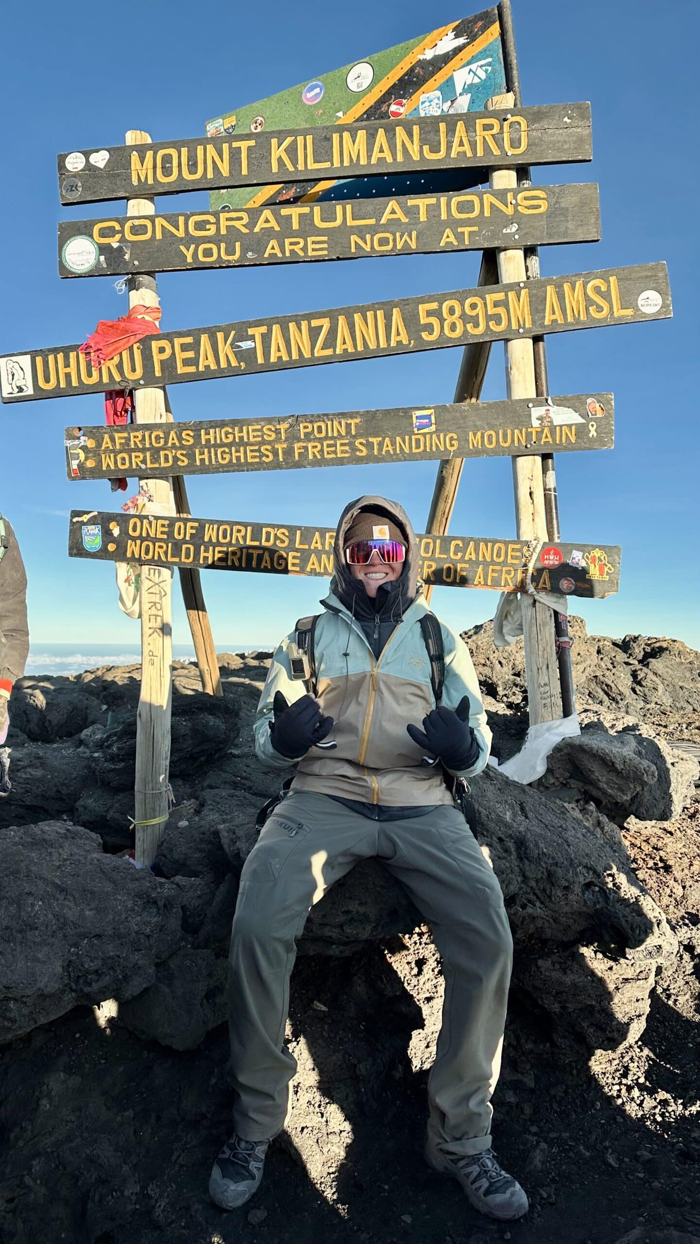
    The Global Summit Guide team on Kilimanjaro, the highest summit in the team's first-hand record
    Kilimanjaro, 19,341 ft (5,895 m), via Lemosho. The roof of Africa and the highest point we have reached.
    About · Our Field Experience

    The real climbs behind our guides

    Anyone can write about mountains. We think you deserve to know who is actually doing the climbing. This is our honest first-hand record: two dozen summits and more than forty ascents from Utah’s Wasatch Range to the roof of Africa, climbs in Patagonia and Iceland, and the high-altitude progression we are on right now. Where our guides go beyond what we have personally climbed, we tell you, and we cite our sources.

    24Distinct summits
    42Total ascents
    19,341 ftHigh point (Kilimanjaro)
    4Continents climbed
    The honest summary

    Deep experience up to 19,000 feet, and honest about the rest.

    Our Climbing & Mountaineering Lead, Dawson Ludlow, has summited more than twenty distinct peaks across more than forty ascents, from repeated Wasatch classics to Kilimanjaro (19,341 ft), Mount Whitney (14,505 ft), and the glaciated Mount Hood.

    With founder Travis Ludlow he has also climbed Pikes Peak, climbed in Patagonia and Iceland, and stood at the foot of Mount Fuji.

    We have not summited Everest or any 8,000-meter peak, and we never pretend otherwise. Next up is a deliberate high-altitude progression: Orizaba, Cotopaxi, and Chimborazo.

    Signature & high-altitude summits

    The climbs that anchor our altitude and glacier experience, and inform how we write about the bigger peaks.

    Kilimanjaro · via the Lemosho route

    19,341 ft (5,895 m) · Tanzania · our highest summit

    The roof of Africa and the highest point we have reached. A non-technical but serious high-altitude trek that taught us first-hand how altitude, pacing, and multi-day fatigue actually feel above 15,000 feet, lessons that shape our Kilimanjaro and altitude guides.

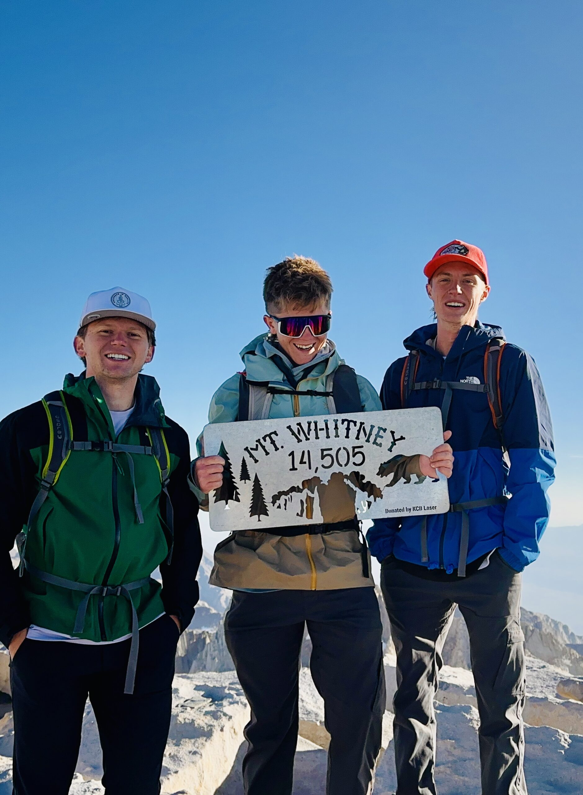
    Mount Whitney

    14,505 ft (4,421 m) · California · highest in the lower 48

    The highest summit in the contiguous United States, a long, demanding day at altitude on the classic route.

    Pikes Peak · Travis and Dawson

    14,115 ft (4,302 m) · Colorado

    A Colorado 14er climbed together, one of several climbs Travis and Dawson have done side by side.

    Mount Hood · via Timberline

    11,249 ft (3,429 m) · Oregon · glaciated volcano

    Our introduction to a glaciated Cascade volcano: crampons, an alpine start, and real snow-and-ice terrain, and a direct stepping stone toward the volcanoes we are climbing next.

    The Wasatch record

    Utah’s Wasatch Range is our home range and the foundation of everything else. Repeated ascents in every season are where judgment is actually built.

    The bulk of our experience is earned close to home, on the peaks of Utah’s Wasatch Range, climbed and re-climbed across seasons and conditions. This is where the unglamorous work of mountaineering happens: learning to read weather, pace a long climb, move on snow, and turn around when a day goes wrong. Highlights include Mount Nebo, the highest peak in the Wasatch, climbed six times; Mount Timpanogos by two different routes including the Everest Ridge; Lone Peak three times via the committing Jacob’s Ladder approach; and Kyhv Peak above Provo four times. These are not exotic objectives, but the accumulated mileage across dozens of ascents is exactly the kind of experience that makes the difference between writing about mountains and knowing them.
    A scene from the team's climbs
    Out on the mountain. First-hand time in real terrain, across seasons and conditions, is where the judgment behind our guides is actually built.

    The full summit table

    Every peak in our first-hand record, with verified elevations and the number of ascents. Grouped by elevation band.

    PeakRoute(s)ElevationAscents
    High-altitude & signature
    KilimanjaroLemosho19,341 ft (5,895 m)1
    Mount WhitneyStandard route14,505 ft (4,421 m)1
    Mount HoodTimberline11,249 ft (3,429 m)1
    Wasatch & Utah 11,000-ft peaks
    Mount NeboNorth Peak Trail11,928 ft6
    Mount TimpanogosTimpooneke; Everest Ridge11,752 ft3
    American Fork Twin PeaksStandard11,489 ft1
    PfeifferhornStandard11,326 ft2
    Lone PeakJacob’s Ladder11,253 ft3
    Mount SuperiorCardiff Pass11,132 ft1
    Box Elder PeakStandard11,101 ft1
    Provo PeakThe Y; Slate Canyon; normal11,068 ft3
    Wasatch & Utah 10,000-ft peaks
    Loafer MountainStandard10,687 ft1
    Santaquin PeakLoafer Mountain Trail10,685 ft1
    Sunset PeakCatherine Pass10,648 ft1
    Gobblers KnobStandard10,246 ft1
    Mount RaymondStandard10,241 ft1
    Spanish Fork PeakStandard10,193 ft2
    Utah peaks under 10,000 ft
    Ben LomondCutler9,712 ft1
    Notch PeakStandard9,655 ft1
    Mount OlympusStandard9,026 ft2
    Y MountainStandard~8,568 ft1
    Grandeur PeakStandard8,299 ft1
    Kyhv PeakRock Canyon7,865 ft4
    Big BaldyStandardWasatch2
    How to read this table

    Twenty-four distinct summits, forty-two total ascents. The repeated climbs matter as much as the list: six trips up Mount Nebo and four up Kyhv Peak represent real, seasonal familiarity, not a one-time tick. Elevations are verified against current records; Big Baldy is listed without a precise figure rather than guess at which of Utah’s several Big Baldys applies.

    International climbing

    Beyond the summits above, Travis and Dawson have sought out mountain terrain around the world.

    Our experience is not confined to North America. Together, Travis and Dawson have climbed in Patagonia, the wild, weather-battered mountains at the southern end of South America, and in Iceland, a landscape of glaciers, volcanoes, and fast-changing conditions. They have also spent time at the base of Mount Fuji in Japan. We are precise about that last one on purpose: we explored Fuji’s lower slopes rather than standing on its summit, and it matters to us to describe experience exactly as it happened. Time in these ranges, on very different rock, ice, and weather than Utah’s, broadens the judgment we bring to writing about mountains everywhere.

    What we are climbing next

    Our experience is not a finished list. We are on a deliberate progression toward higher, glaciated, high-altitude volcanoes, and we will document it as it happens.

    The high-altitude progression, 2026 to 2027

    December 2026

    Pico de Orizaba

    18,491 ft (5,636 m) · Mexico

    North America’s highest volcano and our next high-altitude glacier objective, building on Mount Hood.

    2027

    Cotopaxi

    19,347 ft (5,897 m) · Ecuador

    A classic glaciated Andean volcano and a step up in sustained altitude and glacier travel.

    2027

    Chimborazo

    20,548 ft (6,263 m) · Ecuador

    Ecuador’s highest peak and the farthest point from the center of the Earth, our first objective above 20,000 feet.

    These are goals, not achievements, and we will report honestly on how the preparation and the climbs actually go. Follow the same path in our progression plans and expedition training guides.

    Our honesty policy

    Global Summit Guide covers mountains far higher and more technical than we have personally climbed, including Everest, K2, and the 8,000-meter peaks. We will never blur the line between what we have done and what we have researched. Our first-hand summits top out at Kilimanjaro; everything above that is research-based synthesis drawn from the Himalayan Database, the American Alpine Club, expedition operators, and published accounts, and we cite those sources.

    We believe this honesty makes us more useful, not less. It means you can trust that when we describe how something feels, we have felt it, and when we are working from research, we say so. That is the standard we hold every page on this site to.

    Experience FAQ

    The questions readers ask about who is behind the guides.

    Has the team summited Everest or the 8,000-meter peaks?

    No, and we say so plainly. Our highest summit is Kilimanjaro at 19,341 feet. Our 8,000-meter guides are research-based syntheses from the Himalayan Database, the American Alpine Club, operators, and published accounts, with sources cited.

    What is the team’s highest summit?

    Kilimanjaro, 19,341 feet (5,895 m), via Lemosho. Then Mount Whitney (14,505 ft), Pikes Peak (14,115 ft), and Mount Hood (11,249 ft), plus more than twenty Wasatch summits.

    How does this experience make your guides more reliable?

    First-hand time teaches what no database can: how altitude feels, how fast weather turns, how fatigue erodes judgment on descent. That shapes how we frame difficulty, training, and risk, even for peaks higher than we have climbed, where we are transparent that the work is research-based.

    What are you climbing next?

    A high-altitude progression: Pico de Orizaba (18,491 ft) in December 2026, then Cotopaxi (19,347 ft) and Chimborazo (20,548 ft) in 2027. Glaciated volcanoes that build directly on Kilimanjaro and Mount Hood.

    Who does the climbing?

    Primarily Dawson Ludlow, our Climbing & Mountaineering Lead, with founder Travis Ludlow climbing alongside him, including Pikes Peak and climbs in Patagonia and Iceland. Health and altitude content is reviewed by Taylor Ludlow, RN.

    About Global Summit Guide

    Dawson Ludlow, Climbing & Mountaineering Lead · Travis Ludlow, Founder & Head of Research

    Global Summit Guide is an independent mountaineering resource built on a simple principle: earn trust by being honest about what we know first-hand and what we have researched. This page is our experience record, and we keep it current as we climb. Health and altitude content is reviewed by Taylor Ludlow (Registered Nurse), and gear by Walker Ludlow. Read more about the team and mission.

    Was this helpful?

    Yes
    No
    Thanks for your feedback!
  • Mountains near Denver: a hiker’s guide to the Front Range and closest peaks

    Mountains Near Denver: The Hiker’s Guide to the Front Range and Closest Peaks | Global Summit Guide
    Regional Guides / Colorado

    Mountains near Denver: a hiker’s guide to the Front Range and closest peaks

    14,265 ft
    Mount Evans / Blue Sky
    ~75 min
    Closest 14er drive
    200 mi
    Front Range length
    10+
    14ers within 2 hrs
    Part of the Colorado mountains series This Denver-area guide supports our best mountains near Denver master guide and our complete Colorado 14ers guide. Master guide →

    Denver sits at 5,280 feet, calls itself the Mile High City, and looks out on roughly 200 miles of Front Range mountains visible on most clear days. That kind of access is unusual — no other major US city has dozens of named peaks, multiple 14ers, and a national park all within a two-hour drive. This guide answers the questions Denver-area hikers and visitors actually ask: which mountains can you see from the city, what is the closest 14er, where do you start if you are new to Colorado peaks, and what are the best day-hike objectives within 2 hours of downtown. For the deeper deep-dive on individual peaks, see our best mountains near Denver master guide and our complete Colorado 14ers guide.

    What mountains can you see from Denver

    On any clear day, the western horizon from Denver shows a continuous wall of mountains stretching from north to south, technically the Front Range of the Rocky Mountains. From downtown you can identify roughly 30 named peaks if you know what you are looking for. The most prominent visible peaks, north to south:

    The best Denver-area viewpoints for seeing the mountains are Lookout Mountain in Golden (a 30-minute drive from downtown that puts you directly above the city looking west), Sloan Lake just northwest of downtown, Mount Falcon Park, and the upper floors of downtown buildings facing west. The clearest viewing days are typically after weather systems pass through and clear the air, particularly the morning after rain or snow when haze drops to near zero.

    The viewing reality from downtown

    The peaks visible from Denver are not as close as they look. Mount Evans appears to loom right over the city but is actually 35 miles west. Longs Peak is 50 miles northwest. The apparent closeness is an optical effect of the dry mountain air and the height of the peaks above the surrounding terrain. The mountains are real, they are accessible, but they take 1 to 2 hours of driving to actually reach.

    The closest mountains to Denver

    Different definitions of “closest” produce different answers. If you mean closest named mountain by drive time, Lookout Mountain wins. If you mean closest meaningful mountain experience, the foothills peaks west of Golden and Evergreen are 30-45 minutes from downtown. If you mean closest 14er (peak above 14,000 feet), Mount Bierstadt and Mount Evans tie at roughly 75 minutes. Here are the closest peaks in each category:

    1

    Lookout Mountain (Golden)

    The closest named mountain · Drive-up via Lariat Loop · Easy walking trails · Buffalo Bill Museum and grave site at summit
    7,377 ft
    ~30 minutes from downtown
    2

    Mount Falcon Park

    The closest hiking-only mountain · Multi-trail park · 3-7 mile loops · Castle ruins and Denver views
    7,851 ft
    ~35 minutes from downtown
    3

    Bergen Peak

    The closest substantial summit · 9.4 mile round trip · 1,900 ft gain · Real mountain feel close to the city
    9,708 ft
    ~45 minutes from downtown
    4

    Chief Mountain

    Short summit hike with big views · 3 mile round trip · 985 ft gain · Excellent intro to higher altitude
    11,709 ft
    ~1 hour from downtown
    5

    Mount Bierstadt

    The closest 14er · 7 mile round trip from Guanella Pass · 2,850 ft gain · The standard Denver-area first 14er
    14,065 ft
    ~75 minutes from downtown
    6

    Mount Evans / Mount Blue Sky

    Closest 14er by car · Drive-up to ~14,130 ft via Mount Evans Scenic Byway · Final 100 ft on foot · Seasonal road (May-September)
    14,265 ft
    ~75 minutes from downtown

    The 14ers closest to Denver

    Colorado has 58 named peaks above 14,000 feet (or 53 depending on which counting convention you use). Most are far from Denver — the highest concentrations are in the Sawatch Range to the southwest near Leadville (Mount Elbert, Mount Massive, and others) and in the San Juan Range to the southwest near Lake City and Silverton. But several 14ers are within 1.5 to 2 hours of Denver and are the natural targets for Denver-based hikers building toward bigger objectives. The complete framework is in our Colorado 14ers guide.

    14erElevationDrive from DenverDifficultyNotes
    Mount Bierstadt14,065 ft~75 minClass 2 (easy)The classic Denver first 14er
    Mount Evans / Blue Sky14,265 ft~75 minClass 1 (drive-up)Drive to ~14,130 ft, walk last 100 ft
    Grays Peak14,278 ft~90 minClass 1 (easy)Often combined with Torreys
    Torreys Peak14,267 ft~90 minClass 2 (moderate)Combined Grays+Torreys = single day
    Longs Peak14,259 ft~1.5 hrClass 3 (hard)The Keyhole Route, technical
    Pikes Peak14,115 ft~1.5 hrClass 1 (drive/cog)Drive, cog railway, or 13 mi trail
    Quandary Peak14,265 ft~1.75 hrClass 1 (easy)Near Breckenridge
    Mount Sherman14,036 ft~2 hrClass 2 (easy)One of Colorado’s easiest 14ers
    The standard Denver 14er progression

    Most Denver-area hikers build a Colorado 14er progression in this order: Mount Bierstadt (easy, accessible, classic first 14er) → Grays + Torreys (combo hike, two 14ers in one day) → Quandary Peak (easy class 1, near Breckenridge) → Longs Peak (the technical graduation peak with class 3 scrambling). This sequence builds altitude tolerance, navigation skills, and confidence on increasingly committing terrain across a single hiking season.

    The best day hikes not requiring 14er commitment

    Not every Denver-area mountain experience needs to be a 14er. The Front Range has dozens of excellent day hikes that deliver real mountain experience without the altitude exposure, distance, or technical commitment of 14er routes. These work well for visitors with limited time, hikers building fitness, families, and anyone wanting a meaningful mountain day without the full 14er undertaking.

    1

    Bear Peak (Boulder)

    5.5 mile loop · 2,500 ft gain · One of Boulder’s iconic summits · 360-degree views of Front Range
    8,461 ft
    ~45 min from Denver
    2

    Royal Arch (Boulder Flatirons)

    3.4 mile round trip · 1,400 ft gain · Natural sandstone arch and iconic Flatirons views
    6,920 ft
    ~45 min from Denver
    3

    Devils Head Lookout

    2.8 mile round trip · 940 ft gain · Last manned fire lookout in Colorado · Views from 9,748 ft
    9,748 ft
    ~1 hour from Denver
    4

    Mount Sanitas (Boulder)

    3.1 mile loop · 1,300 ft gain · Boulder’s most popular workout hike · Mountain views without long drive
    6,863 ft
    ~45 min from Denver
    5

    Twin Sisters Peaks (RMNP)

    7.4 mile round trip · 2,500 ft gain · Spectacular views of Longs Peak · Best Longs Peak viewing summit
    11,428 ft
    ~1.75 hr from Denver
    6

    St. Mary’s Glacier

    2 mile round trip · 700 ft gain · Year-round small glacier · Photogenic alpine lake at the base
    10,800 ft
    ~1 hour from Denver

    When to hike mountains near Denver

    Colorado mountain hiking is genuinely four-season but with sharp seasonal patterns. Understanding the seasons saves you wasted trips and improves your odds of finding the conditions you want.

    SeasonConditionsWhat’s openWhat to watch
    March – AprilFoothills clear, high country snowyFoothills, lower trailsMud season, road closures above 9,000 ft
    MaySnow lingers high, foothills greenLower 14ers, foothillsPostholing on high trails, lingering ice
    JuneSnow recedes, wildflowers startMost 14ers accessible mid-monthLingering snow on north-facing
    JulyPeak seasonEverything openAfternoon thunderstorms (start early!)
    AugustPeak season continuesEverything openMonsoon thunderstorms, crowds
    SeptemberStable weather, aspens turnEverything open, fewer crowdsFirst storms typically late month
    OctoberFirst snow, transitionalFoothills, some 14ersRoad closures begin (Mount Evans road)
    November – FebruaryWinter, snow on high trailsFoothills snowshoeing, lower trailsAvalanche risk on high terrain

    The single most important seasonal pattern is the afternoon thunderstorm that builds almost daily during July and August. Front Range 14ers and high peaks routinely produce lightning storms starting around 1 PM through 4 PM. Standard protocol is to start summit attempts at 4-6 AM and be off the high terrain by noon. Climbers and hikers who ignore this pattern have been struck by lightning every season. The mountain weather framework is in our mountain weather guide.

    Getting to the mountains from Denver

    DestinationRouteDrive timeBest for
    Golden / Lookout MountainUS-6 or I-70 W to Exit 256~30 minQuick scenic drive, families
    Idaho Springs / Mount Evans areaI-70 W to Exit 240~45 minMount Evans road access
    Georgetown / Guanella PassI-70 W to Exit 228~75 minMount Bierstadt, Grays, Torreys
    Estes Park / RMNPUS-36 NW via Lyons~90 minLongs Peak, RMNP, Twin Sisters
    Pikes Peak / Colorado SpringsI-25 S~90 minPikes Peak, Manitou Incline
    Boulder Flatirons / Bear PeakUS-36 N~45 minBoulder hiking
    Breckenridge / QuandaryI-70 W to Exit 203~1.75 hrQuandary, Tenmile Range
    Aspen / Maroon Bells (further)I-70 W to CO-82~3.5 hrIconic photos, weekend trips

    I-70 west is the primary mountain corridor and gets congested on weekend mornings during summer and ski season. The local saying is “leave Denver by 5 AM or stay home” for weekend 14er trips. Returning to Denver Sunday afternoon eastbound on I-70 routinely takes 2-3 times the normal drive time due to weekend traffic. Many Denver hikers do Friday afternoon or early Saturday morning trips to avoid the worst congestion.

    The altitude reality for visitors

    Denver altitude affects visitors more than people expect

    Denver sits at 5,280 feet, which is meaningfully above sea level. Visitors arriving from coastal cities may feel mild altitude effects in Denver itself — headache, fatigue, shortness of breath on stairs. The 14ers and high peaks above Denver are at 11,000 to 14,300 feet, which is genuinely high altitude where altitude sickness becomes a real concern. Visitors planning a 14er attempt within their first 2-3 days in Colorado are at meaningfully higher risk of altitude sickness than acclimated locals. The altitude framework is in our altitude sickness guide.

    Practical altitude planning for visitors:

    • Day 1-2 in Colorado: stay below 9,000 ft. Drink water aggressively, avoid alcohol, walk around Denver and adjust.
    • Day 3-4: try a moderate altitude hike (Chief Mountain at 11,709 ft, or Twin Sisters at 11,428 ft) to test how your body responds.
    • Day 5+: 14er attempts become reasonable if you have not experienced altitude symptoms at moderate altitude.
    • Critical: if you feel headache, nausea, fatigue, or dizziness at moderate altitude, descend. Going higher will make it worse, not better. The acclimatization framework is in our altitude acclimatization explainer.

    What to wear and bring on Front Range hikes

    Colorado mountain weather changes fast. A warm sunny morning at the trailhead can be snow, hail, and lightning at the summit two hours later. The standard 10 essentials apply, but a few items matter more in Colorado than in other ranges:

    • Layers, not bulk: a base layer, mid-layer (fleece or puffy), and waterproof shell handle nearly all Colorado mountain weather. Pack all three even on hot July mornings.
    • Sun protection: Colorado sun at altitude burns fast. SPF 30+ sunscreen, sunglasses, and a brimmed hat are not optional.
    • Water: dry air at altitude dehydrates you faster than you notice. Carry 2-3 liters for any 14er day, more for longer hikes.
    • Trekking poles: the descents from 14ers destroy knees. Poles take 20-30% of the impact load off your knees.
    • Microspikes or crampons (off-season): from October through June, snow and ice on north-facing slopes persists. The framework for which to use is in our snow travel gear guide.
    • Headlamp: for early starts and unexpected late descents. Even on summer day hikes.
    • First aid kit: small but real — Band-Aids, ibuprofen, electrolytes, blister treatment.

    Safety in the Colorado mountains honest assessment

    The Colorado Front Range is generally safe for prepared hikers but produces several mountain-related deaths every year. The most common causes:

    1. Lightning strikes on exposed ridges during afternoon thunderstorms (Longs Peak, Mount Evans, Bierstadt, Grays/Torreys).
    2. Falls on steep technical terrain (Longs Peak Keyhole Route, off-trail scrambling).
    3. Hypothermia from unexpected weather (summer climbers caught in snow storms).
    4. Getting lost after dark on descents when fatigue compounds navigation errors.
    5. Altitude sickness escalating to high-altitude pulmonary edema (HAPE) or cerebral edema (HACE) in extreme cases.

    The five rules that prevent most Colorado mountain incidents:

    1. Start early — 4-6 AM trailhead departures for 14ers, off summit by noon.
    2. Check weather — Mountain-Forecast.com and NOAA point forecasts for specific peaks.
    3. Tell someone your plan — leave detailed plan with someone who will alert authorities if you do not check in.
    4. Turn around when needed — the mountain will be there next weekend. Bad weather, sickness, or fatigue all mean turn around.
    5. Carry the gear — water, layers, headlamp, first aid. Even on “easy” hikes.

    Where Front Range hiking fits in the broader progression

    For climbers building toward bigger mountains, the Colorado Front Range serves a specific and valuable role. The 14ers between Denver and Colorado Springs are accessible enough to climb several in a single hiking season, varied enough to build different skill sets (class 1 walking on Mount Evans, class 2 trails on Bierstadt, class 3 scrambling on Longs Peak), and altitude-rich enough to build genuine acclimatization tolerance. The standard progression that includes Colorado 14ers as a step:

    1. Build base fitness: Front Range day hikes, foothill peaks, and shorter trail running.
    2. First 14er: Mount Bierstadt as the introduction to 14,000-foot terrain.
    3. Build the 14er portfolio: Grays + Torreys, Quandary, Mount Sherman as additional easier 14ers.
    4. Technical 14er graduation: Longs Peak via the Keyhole Route — the standard “hardest accessible” 14er from Denver.
    5. Beyond Colorado: Rainier as the introduction to true expedition climbing. Framework in our Rainier progression plan.
    6. Major peaks: Denali and Aconcagua as the next-step expedition mountains.

    This progression works because Colorado 14ers build the foundational skills nearly any North American mountaineer needs: altitude tolerance, navigation, weather decision-making, multi-hour endurance, and confidence on increasingly committing terrain. Climbers who complete several Colorado 14ers are well-positioned for the broader Cascade and Alaska Range progression. The full framework is in our best mountains near Denver master guide and the broader Colorado-specific detail is in our Colorado 14ers guide.

    ★ Master Denver Mountains Guide

    The full Front Range climbing framework

    Detailed peak profiles, route guides, seasonal recommendations, and the complete Colorado 14ers progression from beginner to expert.

    Read the master guide →

    The bottom line on mountains near Denver

    Denver sits at the eastern edge of one of the most accessible high-altitude mountain regions in the United States. The Front Range stretches 200 miles north to south along the city’s western horizon, with dozens of named peaks, multiple 14ers, and Rocky Mountain National Park all within 1 to 2 hours of downtown. The closest 14er is Mount Bierstadt at roughly 75 minutes drive. The most accessible drive-up 14er is Mount Evans / Mount Blue Sky via the seasonal scenic byway. The technical graduation peak is Longs Peak with its class 3 Keyhole Route. Most Denver-area hikers progress from foothill day hikes through easier 14ers to harder objectives across multiple hiking seasons, building the foundation for bigger climbing objectives outside Colorado. Whether you are a Denver local building your local hiking portfolio or a visitor wanting one great mountain day, the Front Range has the right peak for nearly any fitness level. The full peak-by-peak detail is in our best mountains near Denver master guide, with the complete Colorado 14ers framework in our Colorado 14ers guide.

    Frequently asked questions

    What mountains can you see from Denver?

    From Denver you can see roughly 200 miles of the Front Range of the Rocky Mountains stretching north to south along the western horizon. The most prominent visible peaks are Longs Peak (14,259 ft) to the northwest in Rocky Mountain National Park, Mount Evans (14,265 ft, recently renamed Mount Blue Sky) directly west, Pikes Peak (14,115 ft) to the south near Colorado Springs, and Mount Bierstadt (14,065 ft) adjacent to Mount Evans. On a clear day you can identify dozens of named peaks from downtown Denver, with the best viewpoints being elevated locations like Lookout Mountain in Golden or Sloan Lake.

    What is the closest mountain to Denver?

    Lookout Mountain in Golden is the closest named mountain to Denver, at roughly 7,377 feet elevation and only 30 minutes drive from downtown. For a more substantial mountain, Mount Falcon at 7,851 feet and Bergen Peak at 9,708 feet are both within 45 minutes of Denver. The closest 14er (peak above 14,000 feet) is Mount Bierstadt at roughly 1 hour and 15 minutes drive from Denver via I-70 to Guanella Pass. Mount Evans (Mount Blue Sky) is similar distance via the Mount Evans Scenic Byway when seasonally open.

    What is the closest 14er to Denver?

    Mount Bierstadt at 14,065 feet is the closest 14er to Denver by drive time, taking roughly 1 hour and 15 minutes via I-70 west to Georgetown and then south on Guanella Pass Road. Mount Evans (Mount Blue Sky) at 14,265 feet is similar distance via the Mount Evans Scenic Byway when seasonally open (typically late May through September). Both peaks have established hiking trails and are climbable in a day from Denver. Grays Peak and Torreys Peak (both 14,278 ft and 14,267 ft respectively) are about 1.5 hours from Denver and can be combined in a single hike.

    How far are the mountains from Denver?

    The foothills of the Front Range begin roughly 15 to 30 minutes drive west of Denver, with Lookout Mountain in Golden at 30 minutes from downtown. The first 14ers (peaks above 14,000 feet) are 1 to 1.5 hours drive west via I-70. Rocky Mountain National Park (Longs Peak) is approximately 1.5 hours drive northwest. Pikes Peak near Colorado Springs is about 1.5 hours south. Most of the named Front Range mountains visible from Denver are within a 1 to 2 hour drive, making Denver one of the most mountain-accessible major US cities.

    What are the best mountains to climb near Denver?

    The best mountains to climb near Denver depend on your fitness and experience. For beginners, Mount Falcon (7,851 ft), Bergen Peak (9,708 ft), and Chief Mountain (11,709 ft) offer accessible day hikes. For experienced hikers seeking 14er objectives, Mount Bierstadt (14,065 ft) is the most accessible 14er near Denver, followed by Mount Evans/Blue Sky (14,265 ft), Grays and Torreys Peaks (combined 14er day at 14,278 and 14,267 ft), and Longs Peak (14,259 ft, the hardest of the close-to-Denver 14ers with class 3 climbing on the Keyhole Route).

    Can you see the mountains from downtown Denver?

    Yes, you can clearly see the Front Range mountains from downtown Denver on most days. The mountains run north-south along the entire western horizon and are visible from elevated locations like the upper floors of downtown buildings, Sloan Lake just northwest of downtown, and any westward-facing street with clear sight lines. The best viewing days are after weather systems clear the air, typically the day after rain or snow. The mountains appear roughly 30 to 60 miles away depending on which peaks you are looking at, with Mount Evans/Blue Sky being the most prominent from downtown views.

    What is the Front Range of Colorado?

    The Front Range is the easternmost range of the Rocky Mountains in Colorado, running approximately 200 miles north-south along the eastern edge of the Rockies adjacent to the high plains. The range is named for being the first mountains travelers encounter coming from the east. The Front Range includes Rocky Mountain National Park in the north, the peaks west of Denver including Mount Evans and Bierstadt, the Mount Evans wilderness, and Pikes Peak to the south near Colorado Springs. Multiple 14ers (peaks above 14,000 feet) are located in the Front Range, all accessible within 2 hours of Denver.

    Was this helpful?

    Yes
    No
    Thanks for your feedback!
Language »