
Mount Wilhelm Climb Guide: Route, Itinerary & Safety
Mount Wilhelm is Papua New Guinea’s highest mountain and a non-glaciated high-altitude trek rather than a technical alpine climb. The standard Keglsugl route is achievable for a fit hiker—but the rapid ascent to 4,509 metres, pre-dawn rocky summit terrain, wet weather, remote medical support and current Highlands travel-advisory environment make the planning more serious than the technical grade suggests.

Mount Wilhelm is a strenuous high-altitude trek with simple climbing—but complicated travel.
The standard route climbs from the Keglsugl/Gembogl side in Simbu Province through wet montane forest to the Piunde–Aunde lake basin, then leaves in darkness for the rocky summit. Papua New Guinea Tourism describes the mountain as accessible but explicitly advises using a guide.
Official tourism material gives 2–3 days as a typical mountain climb, while Betty’s Place offers 3- and 4-day guided packages. For an international visitor arriving from low elevation, a 3- or 4-day schedule is the better planning baseline because it creates more room for acclimatization and weather.
The mountain itself is not the only decision. Current U.S. travel advice places Papua New Guinea at Level 3 overall and says not to travel to the Highlands region outside Mount Hagen and Goroka. Australia advises a high degree of caution nationally and highlights additional Highlands concerns. Those advisories can affect insurance, transport and booking decisions even when the trail itself is open.
Where is Mount Wilhelm?
Mount Wilhelm rises in Papua New Guinea’s Bismarck Range, with the standard climbing approach coming from the Keglsugl/Gembogl side of Simbu Province.

Mount Wilhelm changes ecosystems quickly—from rainforest to alpine rock.
The lower approach is often wet and muddy, while the summit push can be cold enough for frost or occasional snow. That tropical-to-alpine transition is one of the mountain’s defining planning problems: the same trip demands serious rain protection, warm pre-dawn layers and secure footing on wet rock.

The route: village road-end to lake camp to summit
Official PNG Tourism describes Keglsugl as the established side and places the base area near Piunde and Aunde lakes.
The road-access end of the normal climbing chain. Confirm guide, porter, land-access, transport and hut arrangements before walking.
PNG Tourism describes roughly 3–5 hours from the lower area to the lake camp. The route crosses forest and open highland terrain before reaching basic mountain huts.
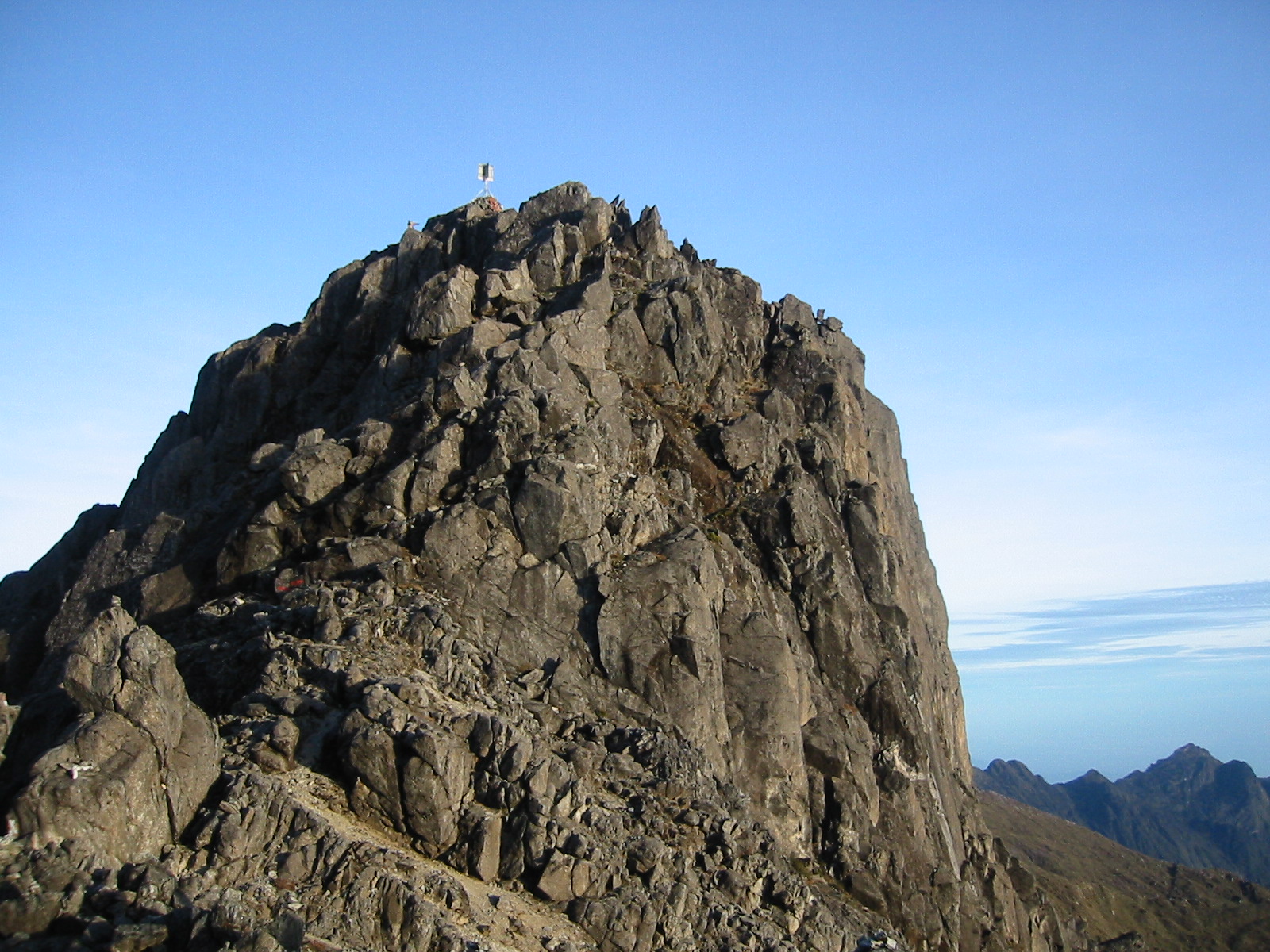
The summit push begins before dawn. Terrain becomes rockier and more exposed to cold, cloud and slippery conditions. Route-finding becomes more important after dark or in mist.
Official tourism guidance gives approximately 4–7 hours from base camp to the summit. Clear early-morning views can deteriorate as cloud builds later in the day.
PNG Tourism gives roughly 6–8 hours for the full summit-to-trailhead descent. Wet rock, fatigue and muddy forest make the descent a substantial part of summit day.
Three days or four days?
Official sources show both shorter and longer formats. The best choice depends less on fitness than on altitude history and travel fatigue.
| Day | 3-day mountain plan | 4-day mountain plan | Why it matters |
|---|---|---|---|
| Day 1 | Keglsugl → lake camp | Keglsugl → lake camp | You may move from relatively low travel elevation to ~3,500 m quickly. |
| Day 2 | Summit → lake camp or lower | Acclimatization / recovery at lake camp | The fourth-day version creates a buffer before the 4,509 m summit. |
| Day 3 | Descend / complete mountain | Summit → lake camp | Separating summit day from the full return can reduce fatigue. |
| Day 4 | — | Descend to Keglsugl | Useful for sea-level visitors or anyone arriving after long international travel. |
You already know you acclimatize well.
A shorter schedule can suit climbers who arrive rested, have recent altitude exposure and are comfortable accepting less weather and acclimatization margin.
You are arriving from low elevation.
The extra day does not guarantee acclimatization, but it is a more conservative way to handle the jump from international travel to a summit above 4,500 metres.
How quickly the altitude stacks up
The mountain’s technical simplicity can hide a compressed altitude profile. This is the key reason to think carefully about itinerary length.
Schematic elevation profile for planning only. Approximate intermediate elevations vary by hut, track and recorded source; it is not a topographic route profile.

No rope does not mean no mountain judgment.
Mount Wilhelm does not normally require glacier equipment or technical climbing hardware on the standard route. But darkness, wet rock, cold, altitude, cloud and fatigue can still turn simple scrambling into consequential terrain. A local guide is valuable because the risk is often navigation and judgment rather than technical difficulty.

What actually makes Mount Wilhelm hard?
The right description is “non-technical but consequentially remote,” not “easy.”
4,509 m arrives quickly.
The itinerary can move a visitor from low elevation to sleeping near 3,500 m in a short period. Headache, nausea, poor sleep and reduced pace are real planning concerns even without technical climbing.
Equatorial does not mean warm on top.
Expect rain lower down, cold before sunrise, wet rock and rapidly forming cloud. Official tourism guidance favors June through September but still describes higher terrain as cold.
The summit push starts in darkness.
Cloud and darkness can obscure the line on the upper mountain. A guide who knows the route is more useful than a generic GPS track when visibility deteriorates.
Wet footing compounds after the summit.
Official estimates place the summit-to-trailhead return at roughly 6–8 hours. That means much of the fall risk comes after the highest point, when fatigue is already accumulating.
Evacuation is not an Alpine hut problem.
Medical facilities and transport are limited compared with mainstream trekking destinations. A minor problem can become a major logistics problem if the group has no communications or evacuation plan.
The mountain begins before the trailhead.
Domestic flights, Highlands road travel, landowner arrangements, local guides, vehicle reliability and security conditions all determine whether the climbing plan functions.
Travel advice is part of the climb plan
The page should not label Mount Wilhelm “safe” or “unsafe” for an individual traveler. It should show the current advisory facts that may affect travel, insurance and logistics.
| Source | Current advice | Mount Wilhelm planning consequence |
|---|---|---|
| United States | PNG Level 3 overall; Highlands region outside Mount Hagen and Goroka listed Level 4 “Do Not Travel.” | Review the exact advisory and insurer response before booking Highlands road travel. |
| Australia | Exercise a high degree of caution in PNG overall; higher levels apply in some areas, including “reconsider” advice for Mount Hagen. | Use reputable transport, verify local security conditions and confirm medical evacuation coverage. |
| United Kingdom | Against all but essential travel to Hela, Southern Highlands and most of Enga; additional caution advised across the Highlands. | Simbu is not currently in the UK’s named all-but-essential list, but local conflict and road conditions still require current local checks. |
Guides, Betty’s Place & the Keglsugl system
Official tourism sources identify Betty’s Place as a long-running gateway operation that works with local communities, guides and porters.
Use a local guide.
Papua New Guinea Tourism says Mount Wilhelm is accessible but “far from an easy climb” and advises trekkers to use a guide. It points travelers toward local accommodation and guide arrangements rather than a permit-heavy commercial expedition system.
A practical gateway rather than a luxury lodge.
PNG Tourism describes Betty’s Place, formerly Betty’s Lodge, as a family-run guesthouse serving the Mount Wilhelm area since 1987. It can arrange three- or four-day guided climb packages, local guides, porters and 4×4 transport.
Goroka → Kundiawa → mountain area.
PNG Tourism describes domestic flight access to Goroka, followed by road travel through Daulo Pass to Kundiawa. The mountain is then reached by Highlands roads toward Gembogl and Keglsugl.
Local access is part of the route system.
Australian travel guidance tells trekkers to ensure trekking companies have arrangements with landowners and a safety plan. This is more useful than assuming a generic “permit” covers every local access issue.
How much does Mount Wilhelm cost?
There is no defensible universal $3,000–$7,000 price. The useful approach is to separate the local mountain package from the international trip total.
| Cost layer | Current evidence | What to verify |
|---|---|---|
| Local package example | PNG Tourism currently lists one 3-night Mount Wilhelm package from K2,563 per person. | Current inclusions, transport origin, guide, food, porter support and whether the offer is still available for your dates. |
| Betty’s Place package | Official tourism listing says 3- and 4-day guided packages are available by enquiry. | Current written quote, group size, vehicle transfer, lodge nights, guide/porter pay and landowner-related charges. |
| Domestic PNG travel | International visitors generally require domestic air and Highlands road transport. | Port Moresby connection, Goroka or other gateway, secure road transport and buffer days. |
| International travel | Varies too much by origin to publish as one durable number. | Airfare, extra hotel nights, visa/eVisa rules, travel insurance and disruption costs. |

Aircraft wreckage on the mountain is a reminder that the route has a human history too.
World War II wreckage remains part of Mount Wilhelm’s landscape. Historical context adds interest to the climb, but the mountain should not be reduced to a scenic summit checklist; local communities, land access and the Highlands travel environment are part of the experience.

June through September is the primary drier window
The mountain is equatorial, so “dry season” does not mean dry trail every day. It means comparatively better odds of stable travel and footing.
| Period | Planning character | Main issue |
|---|---|---|
| June–September | Primary window | Official PNG Tourism identifies these months as drier and more stable; still prepare for rain, cold and cloud. |
| October–November | Transitional | Rainfall generally increases and road/trail conditions may deteriorate. |
| December–March | Wetter period | More persistent rain, slippery track and travel disruption risk. |
| April–May | Improving | Possible climbing, but June–September remains the cleaner planning target in current tourism guidance. |
Pack for wet rainforest and a freezing pre-dawn summit
Mount Wilhelm does not normally require a technical mountaineering rack. The important system is waterproofing, warmth, lighting and reliable trekking footwear.
Waterproof hiking boots
Choose strong wet-rock traction and enough support for a long descent. Technical double boots are normally unnecessary on the standard route.
Waterproof shell + dry storage
Protect insulation, sleep clothing and electronics from persistent moisture. A dry sleeping system matters more than shaving pack weight.
Warm summit layers
Official tourism guidance notes below-freezing conditions can occur at night. Carry insulation, warm hat and gloves for the pre-dawn climb.
Reliable headlamp + spare power
The route commonly begins around midnight or 1 a.m. Lighting is a core navigation tool, not a convenience.
Sleeping bag and pad
Lake-camp facilities are basic. Confirm exactly what your operator or lodge provides before assuming bedding or pads are included.
Offline plan + emergency option
Mobile coverage can be patchy outside major PNG cities. Agree on communications and evacuation procedures before leaving the road system.
Is Mount Wilhelm the highest mountain in Oceania?
The precise answer depends on whether “Oceania” is being used as a geographic region, a political-country grouping or a specific Seven Summits list.
| Peak | Elevation | Why it matters | Seven Summits context |
|---|---|---|---|
| Puncak Jaya / Carstensz Pyramid | 4,884 m | Higher peak on the western, Indonesian side of New Guinea. | Messner-list Oceania summit. |
| Mount Wilhelm | 4,509 m | Highest mountain in the independent country of Papua New Guinea. | Alternative Oceania high-point objective; not standard Messner or Bass summit. |
| Mount Kosciuszko | 2,228 m | Highest point on mainland Australia. | Bass-list Australia/Oceania summit. |
Leigh Vial and two Papua New Guinean companions reached the summit in 1938
Historical summaries often shorten the ascent to Vial’s name alone. A fuller account recognizes the local companions who were part of the summit party.
The first recorded ascent
Papua New Guinea Association historical material records patrol officer Leigh Grant Vial making the first recorded ascent on August 15, 1938. Later summaries identify two Papua New Guinean staff members as part of the ascent.
The mountain existed long before its colonial name.
Mount Wilhelm is also known through local Kuman-language names including Enduwa Kombuglu or related spellings. The modern English name comes from the German colonial period.
What owns the facts on this page
Operational facts come from Papua New Guinea Tourism and current government travel advice. Historical claims use dedicated PNG historical sources.
Papua New Guinea Tourism — Mount Wilhelm
Primary source for elevation, Keglsugl access, typical timings, best months, terrain character and local-guide recommendation.
Betty’s Place — official tourism listing
Used for the current role of Betty’s Place, three- and four-day guided climb packages, guide/porter arrangements and 4×4 transport.
Current travel advice
The broader trip-risk section uses live government guidance rather than generic claims about PNG travel safety.
Price evidence
Instead of inventing an all-in dollar range, this page cites a current PNG Tourism three-night package listing from K2,563 per person and directs readers to current lodge/operator quotes.
First-ascent history
Papua New Guinea Association historical material records Leigh Vial’s August 15, 1938 ascent and later PNGAA material notes that two Papua New Guinean staff accompanied him.
What is deliberately not claimed
No mountain-wide summit-success percentage is published because there is no audited denominator-controlled Mount Wilhelm dataset supporting one. This page also avoids claiming a universal legal guide requirement when the official source’s wording is a strong safety recommendation.
Mount Wilhelm climbing FAQ
These visible answers match the FAQ schema and focus on the questions that matter before booking.
How high is Mount Wilhelm?
Mount Wilhelm is 4,509 metres / 14,793 feet and is the highest mountain in Papua New Guinea.
How difficult is Mount Wilhelm?
It is generally a non-glaciated high-altitude trek rather than a technical mountaineering route. The main difficulties are rapid altitude gain, a dark rocky summit ascent, rain, cold, cloud, route finding and remote logistics.
How long does it take?
PNG Tourism describes a typical two- to three-day climb, while Betty’s Place advertises three- and four-day guided packages. For many international travelers, three or four days is a more conservative planning baseline.
What is the standard route?
The standard route approaches from the Keglsugl/Gembogl side, climbs through montane forest to the Piunde and Aunde lake basin, then makes a pre-dawn summit ascent over rocky upper terrain.
Do I need a guide?
PNG Tourism advises climbers to use a guide and notes that local guiding can be arranged through accommodation or local trekking contacts. Betty’s Place works with surrounding communities and arranges guides and porters.
What is the best time to climb?
June through September is the primary drier-season window in official PNG Tourism guidance. Rain and cloud remain possible year-round.
How much does it cost?
There is no single all-in price. PNG Tourism currently lists one three-night package from K2,563 per person, while Betty’s Place offers three- and four-day packages by enquiry. International flights, domestic travel, insurance and extra hotel nights can materially change the total trip cost.
Is Mount Wilhelm one of the Seven Summits?
Not on the standard Messner or Bass lists. The Messner list uses Puncak Jaya / Carstensz Pyramid and the Bass list uses Mount Kosciuszko. Mount Wilhelm is Papua New Guinea’s national high point and an alternative Oceania objective.
Is Mount Wilhelm safe to visit right now?
Travel risk needs to be checked against current government advice. As of September 2026, the U.S. advises against travel to the Highlands region outside Mount Hagen and Goroka, while Australia advises a high degree of caution in PNG overall and higher caution in some Highlands areas. Verify the exact current wording, operator security plan and insurance coverage before booking.
Treat it as a serious remote trek, not an easy 4,500-metre checkbox.
The climbing is relatively simple. The judgment is not. A strong Mount Wilhelm plan combines a conservative altitude schedule, a local guide, early summit timing, waterproof and cold-weather systems, secure Highlands transport, current travel-advisory review and a clear evacuation plan.
Study the Mount Wilhelm RoutesRoute detail, gear, Oceania peaks & altitude planning
This page owns the practical Mount Wilhelm climb plan. Use the pages below for route detail, broader mountain context, regional comparisons and preparation tools.
Mount Wilhelm & the Peaks of Oceania
Papua New Guinea’s highest is a wild jungle-to-summit climb. See where it sits among Oceania’s peaks below.