
Mount Wilhelm routes guide: the keglsugl standard route and the ambullua alternative
Mount Wilhelm — Enduwa Kombuglu in the local Kuman language, or Kombugl’o Dimbin, or Korikhl Khu in Upper Jimi — rises to 4,509 m (14,793 ft) in the heart of the Bismarck Range, the highest point in Papua New Guinea and a contender for the highest mountain in Oceania. Unlike the technical Alpine 4,000-meter peaks of Europe, Mount Wilhelm is a non-technical climb on a well-established trail. There is no glacier travel, no fixed ropes, no via ferrata cables, and no rock-climbing pitches. There is also no crowd: the mountain sees only a fraction of the climbers who attempt similar-altitude peaks in Nepal or East Africa.
This guide covers both documented routes to the summit: the standard Keglsugl route from the Simbu Province side via the twin lakes of Piunde and Aunde, used by virtually all commercial trips and almost all independent climbers, and the much rarer Ambullua route from the northern Jimi valley side, a four-day wilderness traverse for adventurers seeking a more committed experience. The Keglsugl route is the practical choice for almost everyone. The Ambullua route is documented here for context, but readers should expect to spend most of their planning energy on the Keglsugl approach.
Route comparison at a glance
Mount Wilhelm has only two documented routes, and the comparison is straightforward: one is the established climbing line that virtually everyone uses, and one is a remote wilderness traverse that requires substantial extra commitment.
| Route | Difficulty | Trailhead | Trip length | Frequency |
|---|---|---|---|---|
| Keglsugl Route (Standard) | Non-technical · Strenuous | Keglsugl village, Simbu Province | 3-4 days from Goroka | ~99% of all ascents |
| Ambullua Route (Northern Approach) | Non-technical · Wilderness | Ambullua, Upper Jimi valley | 4-day approach | Rare |
What “non-technical” means on Mount Wilhelm
Non-technical does not mean easy. On Mount Wilhelm it means: no ropes, no crampons, no ice axe, no technical climbing skill required. What climbers do need is altitude tolerance up to 4,509 m, fitness for a 6-hour pre-dawn ascent gaining roughly 950 m of vertical from Lake Piunde, willingness to walk in tropical rain through montane forest, and sure-footedness on rock-and-grass slopes above the lake basin that become treacherous when wet. Six people have died on Mount Wilhelm in documented modern fatalities (1971, 1995, 2001, 2005, 2007 — plus the 1944 WWII bomber crash) — most from inadequate preparation, altitude problems, or unexpected weather. The mountain is accessible but it must be respected.
1. Keglsugl Route — the standard ascent
The Keglsugl route is the standard climbing line and has been since the first recorded ascent by Australian government patrol officer Leigh Vial with two native Papuans in the mid-1930s. The route starts in the small village of Keglsugl at approximately 2,600 m, reached by 4-wheel-drive from Kundiawa via a road that ends at the village. From Keglsugl the trail climbs through high-elevation montane rainforest, then alpine grassland, into the glacial valley containing the twin lakes of Piunde (lower) and Aunde (upper), and then up the final scrambling pitch to the summit at 4,509 m.
Keglsugl Route (Standard)
Non-technical · StrenuousDay 1 — Goroka to Keglsugl (4-hour drive)
Most international climbers fly from Port Moresby (POM) to Goroka (GKA) in the Eastern Highlands on Air Niugini’s morning service. From Goroka airport, a pre-booked 4-wheel-drive vehicle and driver takes you west on the scenic Highlands Highway, through the Chimbu (Simbu) Province and the provincial capital Kundiawa, arriving at the small town of Keglsugl in the late afternoon. The drive takes about 4 hours and passes through some of the most culturally rich highland landscape in Papua New Guinea. An alternative starting point is Mount Hagen (HGU) for trips combining the climb with the famous annual Goroka Show.
Overnight is typically at Betty’s Place (also called Betty’s Lodge) — the well-known and reliable guesthouse in Keglsugl that has served as the standard base for Mount Wilhelm climbers for decades. Other small lodges exist in the area. The lodge serves home-style meals and provides briefing, guide hire, and porter arrangements for the climb. Expect a 2-star level of accommodation with running cold water and basic facilities.
Day 2 — Keglsugl to Lake Piunde base camp (3-4 hours)
The trek from Keglsugl to Lake Piunde is a moderate 3-4 hour walk that gradually climbs through the lower mountain rainforest, alpine grasslands, moss-coated forests, and finally into the dramatic glacial valley containing the twin lakes. The track includes four traditional rest stops along the way. The forest here is home to several birds of paradise — Stephanie’s Astrapia and other highland species can be seen and heard along the route. Light hiking is the order of the day; the trail is well-defined and not technical.
The base camp sits at Lake Piunde at approximately 3,560 m. There are two shelters here: a former Australian National University monitoring station and an A-frame hut. The huts are basic — wooden bunks, a covered cooking area, no electricity, no running water (water is collected from the lake). After arrival and a hot lunch, the standard recommendation is to take an afternoon walk up to Lake Aunde (the upper lake at roughly 3,650 m) for altitude acclimatization. The afternoon walk is approximately 1 hour each way and is essential preparation for the summit attempt.
Day 3 — Summit day (01:00 start)
The summit attempt begins at midnight to 01:00 with a wake-up by your guide. The track from Lake Piunde climbs steeply up a defined trail by headlamp or moonlight. The first 2-3 hours gain approximately 600 m to the upper grassland and rocky terrain at around 4,000 m. The track is “clear with guides and reasonably easy to follow in the dark” per established trip reports — though local guides are absolutely essential since the upper slopes in cloud can be disorienting. Multiple climbers over the decades have lost their bearings on the upper mountain in poor visibility.
From 4,000 m, the route traverses the ridges heading toward the summit. Four sections require sure footing on rock and grass slopes; in wet weather these sections can be treacherous. The terrain involves scrambling rather than climbing — both hands occasionally used for balance, but no roped protection. Guides typically carry hot tea flasks to warm climbers during the pre-dawn ascent.
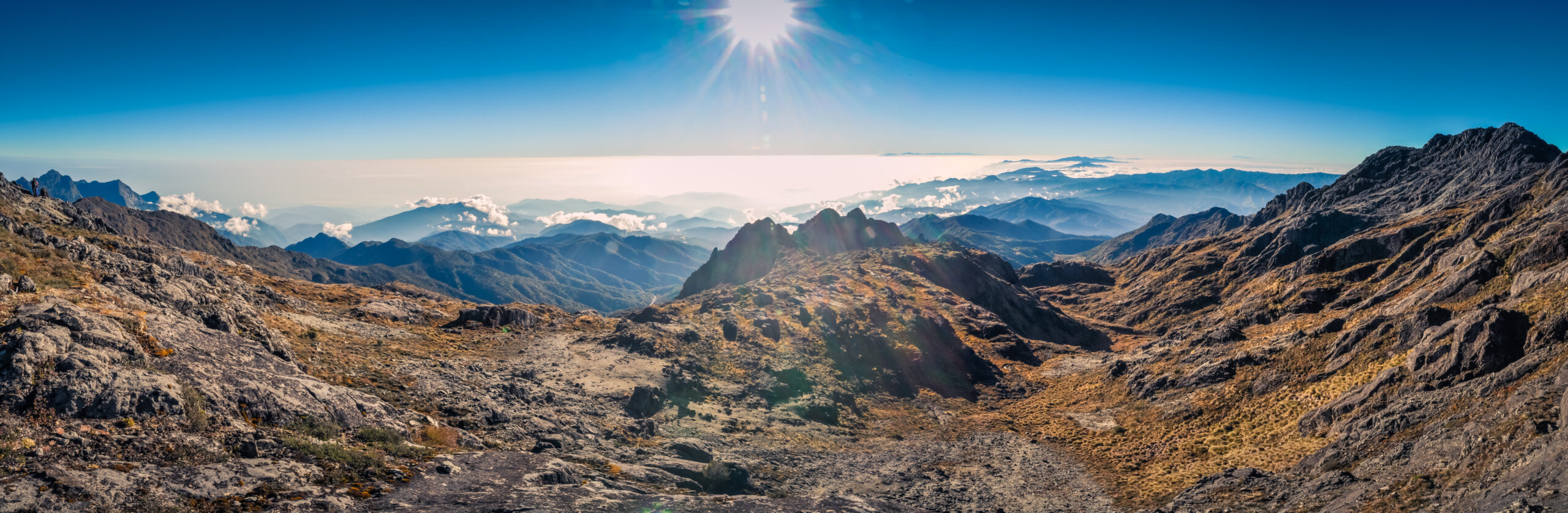
The goal is to reach the 4,509 m summit by 07:00 at sunrise. The early arrival is critical: the daily weather pattern means the sky is clear in the early morning, but the fog laying low in the valley lifts by 09:00, large cloud formations gather at higher altitudes through midday, and intermittent mist and showers continue until sunset. A summit reached after 09:00 is typically in cloud with no views. From the summit at sunrise on a clear morning, the panoramic views can reach as far as the Bismarck Sea on the north coast, with the surrounding highland valleys spread out below.
The descent retraces the ascent line. Most parties descend to Lake Piunde for a second night at the A-frame hut, then continue down to Keglsugl on Day 4. Strong parties with good acclimatization may descend all the way from the summit to Keglsugl in a single very long day, making the summit-day round trip 18-24 hours.
Day 4 — Return to Goroka
After breakfast at Keglsugl (or at Lake Piunde the previous night), the trek descends back to Keglsugl, the 4WD vehicle takes climbers back to Goroka via the Highlands Highway. Most parties spend a night in Goroka before flying back to Port Moresby on the morning Air Niugini service.
Editor’s note: the weather window matters
The 07:00 summit-arrival target is not a guideline — it is the operating principle of the entire climb. The “sky around Wilhelm is usually clear in the early morning, but by nine the fog that is laying low in valley lifts. Large cloud formations gather at higher altitudes and by midday intermittent mist and showers occur, usually until sunset.” Climbers who delay the start, move slowly, or take long stops on the way up usually summit in cloud with no views. The mountain rewards an early start and steady, unbroken movement to the top.
2. Ambullua Route — the northern wilderness alternative
The Ambullua route is the second documented approach to Mount Wilhelm, named for the village in the Upper Jimi valley on the northern side of the Bismarck Range. In the Upper Jimi language spoken in Ambullua, the mountain is known as Korikhl Khu. The route is a four-day wilderness traverse rather than a day-hike-and-summit-attempt — fundamentally different in character from the Keglsugl route and rarely climbed by international visitors.
Ambullua Route (Northern Approach)
Non-technical · WildernessWhat the route is
The Ambullua approach climbs the mountain from the north, where the Bismarck Range drops dramatically toward the Ramu Valley — from over 4,000 m to less than 600 m in only 13 km. The trek passes through the remote villages and forest of the Upper Jimi region, ascends through montane forest and grasslands, and approaches the summit ridge from the north before joining the upper section of the standard route for the final ascent. The full approach is “a much more challenging four-day hike, suitable for those seeking a more demanding and extended experience” according to global parks documentation.
Why it’s rarely climbed
- Logistically demanding — Ambullua is not on a paved road, requires private transport and substantial advance arrangement
- No established lodge infrastructure — the route is genuinely wilderness, camping or village-stay only
- Few commercial operators offer it — most PNG trekking companies focus on the Keglsugl route exclusively
- Cultural permissions required through the customary landowners on the Upper Jimi side
- Same summit, much longer commitment — for most climbers, the standard Keglsugl route delivers the summit with far less complexity
Who this route is for
The Ambullua route is suited to adventurers with prior PNG experience, time flexibility, and a genuine interest in the cultural and ecological transition from the Upper Jimi to the Bismarck Range. Birdwatchers and ecologists may find the route attractive for the changing forest types and the higher chance of seeing birds of paradise away from the more-trafficked Keglsugl approach. The route requires substantial logistical groundwork — most parties arrange it through specialist PNG trekking companies with established connections in the Jimi region.
Lake Piunde and Lake Aunde — the base camp
Both routes converge on Lake Piunde as the staging point for the final summit attempt. The twin lakes — Piunde (lower, at 3,560 m) and Aunde (upper, at 3,650 m) — sit in a dramatic glacial basin carved out during the last ice age, the Pleistocene period approximately 10,000 years ago. The lakes carry their local Kuman names: in tradition, Piunde and Aunde are the “male and female” lakes, the upper feeding the lower.
The base camp at Lake Piunde has two huts:
- The A-frame hut — the more comfortable option, with wooden bunks for roughly 10-12 climbers, a covered cooking area, and shelter from the frequent rain. Most commercial trips use this hut.
- The former Australian National University monitoring station — older, more basic, used for overflow or by independent parties
Neither hut has running water, electricity, or formal sanitation. Water is collected from the lake and treated. Cooking is by camping stove or open fire in the covered area. Hut fees are paid to the local landowner representatives at Keglsugl or directly at the base camp. The huts can be cold at night — the area is well above the 2,700 m frost line, and pre-dawn temperatures regularly drop below freezing.
Weather pattern — the daily cycle that drives the schedule
Mount Wilhelm’s weather is dominated by a daily convection cycle typical of tropical high mountains. Understanding the cycle is essential to understanding why the standard route is structured around a 01:00 start and a 07:00 summit:
- Pre-dawn (04:00-06:00): Coldest temperatures of the day. Clear skies above 3,500 m, stars visible. Often hard frost on the trail.
- Early morning (06:00-09:00): Sunrise around 06:00. Sky remains clear at altitude. Fog often lying in the valleys below.
- Mid-morning (09:00-11:00): Valley fog lifts. First cumulus build-up over higher peaks. Last good visibility window for summit panoramas.
- Midday (11:00-14:00): Large cloud formations gather around the summit. Visibility drops. Intermittent mist begins.
- Afternoon (14:00-18:00): Showers and steady mist. Cloud-cap on the summit. Visibility often only a few meters.
- Evening (18:00-22:00): Showers ease. Cloud-cap may clear briefly. Temperatures dropping rapidly.
- Night (22:00-04:00): Generally clearer than daytime. Cold, frosty. Good for the 01:00 summit start.
Above 2,700 m frost occurs nightly throughout the year. Snow occasionally falls above 4,000 m, but the mountain does not carry permanent snow or glaciers — those disappeared at the end of the last ice age, leaving the dramatic glacial valleys that hold the lakes today.
Historical context — accidents and the WWII crash
Mount Wilhelm has a well-documented history of accidents that climbers should respect. The mountain is accessible, but accessibility breeds underestimation, and the combination of altitude, weather, and remote location has cost several lives.
1944 — American B-24 Liberator “Under Exposed”
On 22 May 1944 during World War II, an American F-7A (a converted B-24 Liberator) named “Under Exposed” crashed into Mount Wilhelm while flying too low on a reconnaissance mission. The aircraft had departed from Nadzab airbase near Lae for a mission to photograph Padaidori Island in Dutch New Guinea. Around 04:00 the plane crashed into the mountain at approximately 4,000 m, just above the twin lakes. All of the crew were killed, and most of the wreckage landed in the upper lake (Lake Aunde), though some can still be seen along the route today. The bodies were recovered; the wreckage remains as a historical site visible from the trail.
1971 — Christopher Donnan
In December 1971, Australian Army Sergeant Christopher Donnan died when he fell down a steep slope on the upper mountain. A plaque marks the point where he was last seen. The plaque has become an unofficial waypoint for climbers and a reminder that the seemingly straightforward upper slopes are not forgiving of mistakes.
1995-2007 — Additional fatalities
The mountain has claimed additional lives in the modern era:
- August 1995: An Israeli backpacker died after spraining his ankle on the upper mountain and staying behind while his group continued. The accident underscores the rule that no one is left alone on the upper mountain regardless of injury severity.
- 2001: A high school student from Muaina High School participating in a school expedition died at the base of Lake Piunde. He was later found to have suffered from asthma.
- July 2005: Bob Martin, a 58-year-old marketing manager at Air Niugini, suffered a heart attack and died near the summit.
- 2007: A local Papua New Guinean from Tari died a few meters south of the Christopher Donnan plaque from falling rock fragments while wearing only “sporting suit, T-shirt and Dunlop shoes” — a stark reminder of the need for proper equipment even on what looks like an easy climb.
The accessibility trap
Mount Wilhelm’s well-deserved reputation as the most accessible mountain in Papua New Guinea creates a hazard: climbers underestimate it. The mountain has no glaciers, no fixed ropes, and no technical demands — but it does have 4,509 m of altitude, sub-freezing pre-dawn temperatures, fast-developing weather, several sections of rocky scrambling above the lakes, and a documented fatality history. The 2007 fatality of a man “wearing only his sporting suit, T-shirt and Dunlop shoes” who was killed by rockfall is the cautionary tale here. Hire a local guide, dress for the conditions, start at 01:00, and turn around if the weather is wrong — these are not optional precautions on a “non-technical” climb.
Choosing your route
For the vast majority of international climbers, the choice is straightforward:
- First Mount Wilhelm ascent, standard objective: Keglsugl route. The established trail, the reliable Betty’s Place lodge base, the experienced local guide network, the documented 01:00 alpine-start template. This is what 99% of climbers do, and there is no reason to deviate unless you have specific reasons.
- Repeat ascent or wilderness experience: Ambullua route. The four-day northern approach delivers a genuinely different experience, with cultural depth and ecological transitions that the Keglsugl day-walk cannot match.
- Climber combining Wilhelm with other PNG objectives: Keglsugl route paired with the Kokoda Trail or the Goroka Show, which is the standard package most PNG-focused operators sell.
- Seven Summits aspirant counting Wilhelm as Oceania: Keglsugl route. The standard ascent satisfies the Seven Summits requirement for those who include Wilhelm rather than Puncak Jaya or Kosciuszko.
Whichever route you choose, Mount Wilhelm rewards the commitment with one of the most distinctive summit experiences in world mountaineering: a tropical-alpine mountain in a country most climbers never visit, a mountain that has been climbed for less than a century, and a summit that depending on how you count the Oceania boundary may be the highest point in an entire continent.
Other parts of the Mount Wilhelm guide
Routes is one of six topics covered in the full Mount Wilhelm climbing guide. Each sub-guide goes deep on one aspect of the climb.
Routes Guide
The Keglsugl standard route via Lake Piunde and the rare Ambullua northern alternative — what to expect on PNG’s highest peak.
Gear List
The complete equipment list for the non-technical climb — boots, sleeping system, tropical-alpine layering, and what Betty’s Place provides.
Permits & Logistics
Coming soon — PNG visa, Air Niugini flights to Goroka, 4WD transfer to Keglsugl, hut fees, and Betty’s Place booking.
Training Plan
Coming soon — fitness preparation for a 6-hour pre-dawn ascent to 4,509 m on rocky terrain.
Weather & Best Season
Coming soon — the daily weather cycle, the dry-season window, and why the 01:00 start is non-negotiable.
Difficulty & Safety
Coming soon — why “non-technical” doesn’t mean easy, the historical accident record, and the seven safety rules for climbing Mount Wilhelm.
Mount Wilhelm routes — frequently asked questions
What is the standard route on Mount Wilhelm?
The standard route on Mount Wilhelm is the Keglsugl route, starting from the village of Keglsugl at the end of the road from Kundiawa in Simbu Province. The route ascends through montane tropical forest, followed by a glacial valley with alpine grasslands, to the twin lakes of Piunde and Aunde where the base camp is established at approximately 3,560 m. From Lake Piunde, climbers typically depart at 01:00 in the early morning for a 6-hour ascent to reach the 4,509 m summit by sunrise around 07:00, before midday cloud cover obscures the views. The route is non-technical but several sections past Lake Aunde require sure footing, particularly in wet weather. The entire ascent and descent typically takes 9 to 24 hours depending on fitness and conditions.
How difficult is Mount Wilhelm to climb?
Mount Wilhelm is a non-technical climb on the standard Keglsugl route — no ropes, crampons, ice axes, or technical climbing skills are required. The mountain is described by tour operators as “the most accessible mountain to climb in Papua New Guinea”. However, the climb is not easy: it requires good fitness for a 6-hour pre-dawn ascent gaining roughly 950 m of vertical, altitude tolerance up to 4,509 m, and the ability to handle scrambling terrain on rock and grass slopes that become treacherous in wet weather. Several sections past Lake Aunde demand sure footing, and the standard summit attempt begins at 01:00 in darkness. Fitness, warm clothing, and altitude awareness are essential — the mountain has a documented fatality record including a 2007 death from rockfall and a 2005 fatal heart attack near the summit.
How long does it take to climb Mount Wilhelm?
A standard Mount Wilhelm climb takes 3-4 days from arrival in Goroka or Mount Hagen. Day 1 is the 4-hour drive from Goroka via Kundiawa to Keglsugl with overnight at Betty’s Place or another local lodge. Day 2 is the 3-4 hour trek from Keglsugl to Lake Piunde base camp at 3,560 m, with an afternoon acclimatization walk to Lake Aunde recommended. Day 3 is the summit attempt: 01:00 start, 6 hours to summit, return to base camp or all the way down to Keglsugl, totaling 9-24 hours of activity depending on energy and conditions. Day 4 is the descent back to Goroka. Adding an extra rest day at base camp before the summit attempt is strongly recommended for altitude adaptation, making the trip 4-5 days total.
What is the second route on Mount Wilhelm?
The second route on Mount Wilhelm is the Ambullua approach from the northern Jimi valley side. The Ambullua route is a four-day hike, suitable for those seeking a more demanding and extended wilderness experience compared to the standard Keglsugl route. The Ambullua side approaches through the Upper Jimi region where the local name for Mount Wilhelm is Korikhl Khu. The route is rarely climbed compared to Keglsugl, sees almost no commercial traffic, and requires substantially more remote logistical support. For most international climbers, the Keglsugl route is the practical choice — the Ambullua route is for adventurers seeking a more committed and culturally immersive experience in less-visited parts of the Bismarck Range.
Why do climbers start at 01:00 on Mount Wilhelm?
The 01:00 alpine start on Mount Wilhelm is dictated by the daily weather pattern in the PNG highlands. The sky around Wilhelm is usually clear in the early morning, but by 09:00 the fog laying low in the valley lifts to higher elevations. Large cloud formations gather at higher altitudes through midday, and intermittent mist and showers occur from midday until sunset. Climbers leaving Lake Piunde at 01:00 reach the summit by 07:00 — just at sunrise — and enjoy the only reliable clear-weather window of the day before the clouds form. The track is clear with guides and is reasonably easy to follow in the dark by moonlight or headlamp. Guides typically carry hot tea flasks to warm climbers during the pre-dawn ascent.
Is Mount Wilhelm the highest mountain in Oceania?
Mount Wilhelm at 4,509 m is the highest mountain in Papua New Guinea and is sometimes considered the highest in Oceania, but the title is disputed. Puncak Jaya at 4,884 m in the Indonesian province of Papua is physically higher and located on the same island of New Guinea, but Puncak Jaya is in Indonesia which is geographically Asian by many classifications rather than Oceanian. Based on present political boundaries treating Indonesian Papua as Asian, Mount Wilhelm may be considered the highest mountain in Oceania (including Australia and New Zealand). Based on physical geography of the island, Puncak Jaya contends for the same title. Some Seven Summits lists include Mount Wilhelm as the Oceania summit, others Puncak Jaya, and still others Mount Kosciuszko in Australia.