
Mulhacén routes guide: all major trails to mainland Spain’s highest peak
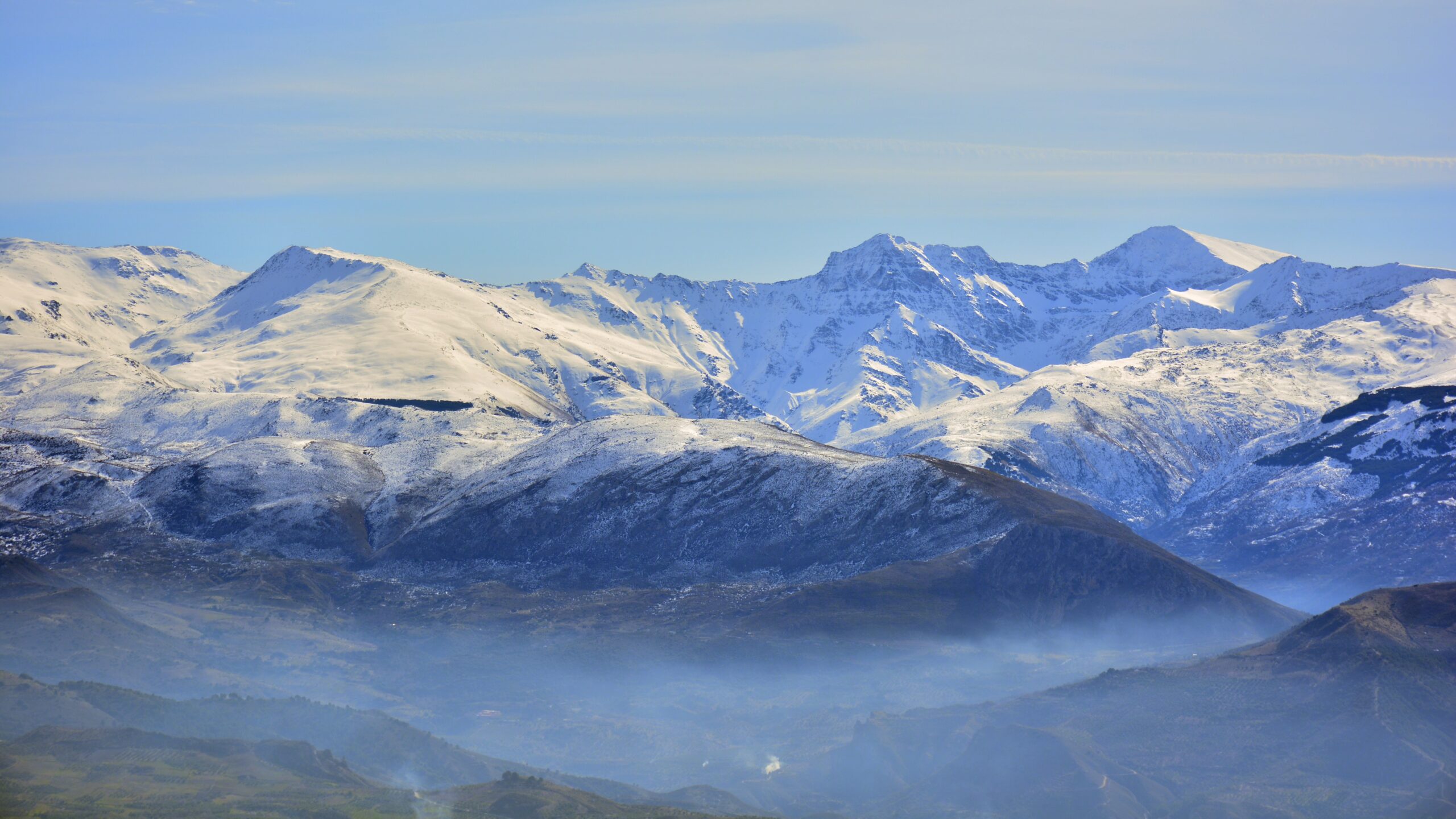
Mulhacén (3,479 m) is the highest peak in mainland Spain and the highest in the Iberian Peninsula — and unlike most 3,000-meter mountains, it can be reached by an established hiking trail with no technical climbing required. The question is which trail. Five distinct routes lead to the summit, ranging from a 4-hour shuttle-bus approach to a 28-kilometer endurance hike. This guide breaks down every major route — the Capileira shuttle route, Hoya de la Mora traverse, Refugio Poqueira, Trevélez via Siete Lagunas, and Hoya del Portillo — with distance, elevation gain, and difficulty grade so you can match the right route to your fitness, time, and crowd tolerance. For the full mountain context, see the Mulhacén hiking guide.
Route overview at a glance
Five established routes account for nearly all summer ascents of Mulhacén. They differ primarily in starting elevation, total distance, and access logistics — the technical character of the climbing itself is similar across all routes (hiking trail with some loose ground and minor scrambling near the summit). The shuttle-bus route from Capileira is by far the most popular because it eliminates approximately 1,500 meters of road walking by dropping hikers at 2,600 meters.
| Route | Difficulty | Distance (RT) | Elevation gain | Time | Trailhead |
|---|---|---|---|---|---|
| Capileira shuttle (Alto del Chorrillo) | Moderate | ~12 km point-to-point | ~900 m | 4 hrs up, 3 hrs down | Bus from Capileira |
| Refugio Poqueira (2-day) | Challenging | ~10 km summit day | ~986 m summit day | 6 hrs summit day | Capileira or Trevélez |
| Trevélez via Siete Lagunas | Challenging | ~22 km loop | ~1,800 m | 9–10 hrs | Trevélez village |
| Hoya del Portillo | Tough | ~23 km | ~1,331 m | ~9 hrs | Hoya del Portillo |
| Hoya de la Mora traverse | Tough | ~28 km point-to-point | ~1,340 m up, 387 m down | 9–10+ hrs | Pradollano ski resort |
Mulhacén’s reputation as a relatively accessible 3,000-meter peak depends almost entirely on the Sierra Nevada National Park shuttle bus that runs from Capileira to Alto del Chorrillo at 2,600 m. Without the bus, every route adds 8-15 kilometers of dirt-road walking with significant elevation gain. The bus operates only during the summer season (roughly late June through mid-September) and must be reserved in advance via the Sierra Nevada Information Office in Capileira (email: siacsur@gmail.com). If you’re planning a Mulhacén trip, book the bus before booking your flight — it’s the single biggest factor in route choice.
Understanding hiking grades why “moderate” can still be hard
Mulhacén routes are graded using standard European hiking difficulty scales rather than alpine climbing grades. The mountain is a hike, not a technical climb — but altitude, distance, and exposure can make even “moderate” routes physically demanding for unprepared hikers.
Mulhacén hiking grade scale
- EasyShort distance, minimal elevation gain, marked trails. Not applicable to Mulhacén — even the shortest route is moderate due to altitude.
- Moderate5–12 km with up to 1,000 m gain, well-marked trails, good fitness required. Capileira shuttle route fits here despite the altitude.
- Challenging10–22 km with 800–1,800 m gain, longer day, requires hiking experience. Refugio Poqueira and Trevélez routes.
- Tough20–28 km with 1,300–2,000 m gain, full day of hiking, fitness essential. Hoya del Portillo and Hoya de la Mora.
- ExpertWinter ascents requiring mountaineering skills, snow travel, and crampons. Same routes but in winter conditions.
The key insight: the grade isn’t about technical difficulty — it’s about distance, elevation gain, and time at altitude. A “moderate” Mulhacén route is meaningfully harder than a “moderate” sea-level hike because the air at 3,479 meters contains about two-thirds as much oxygen as at sea level. Most hikers feel the altitude on the upper sections regardless of route.
The Capileira shuttle route the standard summer approach
Capileira shuttle to Alto del Chorrillo
What the route involves
The shuttle bus from Capileira village (1,436 m) delivers hikers to Alto del Chorrillo, also known as Mirador de Trevélez, at approximately 2,600 meters. The drop-off is typically scheduled for early morning, around 8:00–9:00 AM. From there, the trail climbs steadily through high alpine terrain toward the summit, gaining roughly 900 meters over 5 kilometers of well-defined path.
The route is clearly marked by cairns rather than painted blazes, but the trail is well-trodden and easy to follow in good visibility. The terrain transitions from grass and low alpine vegetation in the lower sections to rocky scree near the summit. The final summit push involves loose ground but no technical scrambling.
After reaching the summit and enjoying the views — Mediterranean to the south, Sierra Nevada peaks in every other direction — hikers descend back to the Alto del Chorrillo pickup point in approximately 3 hours. The shuttle bus typically returns to Capileira around 4:00 PM.
Why this is the popular choice
The shuttle eliminates the worst of Mulhacén’s hidden challenge: the long, exposed road walking from the valley floor to the high trailheads. A 4-hour ascent from 2,600 m is achievable for most fit hikers; a 9-10 hour day starting from Capileira village is a different kind of effort altogether. The shuttle also means hikers can summit on a single day trip from Granada or the Alpujarras villages, no overnight required.
The Refugio Poqueira route the two-day option
Refugio Poqueira — split the climb across two days
How the two-day plan works
Day 1 ascends from Capileira (1,436 m) or via a connector trail to the Refugio Poqueira at approximately 2,500 meters. This first day is about 4-5 hours of hiking with around 1,100 meters of elevation gain. The refuge is a staffed Spanish mountain refuge serving meals and offering dormitory accommodation — reservations are required, especially in peak season.
Day 2 begins early with the summit attempt. From the refuge, the route climbs roughly 1,000 meters over 5 kilometers to the Mulhacén summit, then descends back to the refuge or continues down to a different exit point. Total summit day is approximately 6 hours including time at the top.
Why split the climb
The Poqueira route is the right choice for three types of hikers: those who want to acclimatize before the summit push, those who don’t want a 9-10 hour single-day effort, and those who want to experience the mountain at sunset and sunrise from altitude. The refuge sits in spectacular high terrain, and many hikers describe the experience as more rewarding than a fast day-trip approach.
The Trevélez via Siete Lagunas route the scenic loop
Trevélez and the Cañada de las Siete Lagunas
What this route offers
Trevélez is the highest permanently inhabited village in mainland Spain, sitting at 1,486 meters in the Alpujarras south of the main Sierra Nevada ridge. From here, the route climbs through alpine meadows and along the Río Culo de Perro before entering the spectacular Cañada de las Siete Lagunas — the “valley of the seven lakes,” a glacial cirque that holds Mulhacén’s most dramatic scenery.
From the upper Siete Lagunas at Laguna Hondera, the route climbs steeply to gain the southeast ridge of Mulhacén, then follows the ridge to the summit. The descent typically returns the same way or completes a loop back to Trevélez via a different drainage.
Why hikers choose this route
The Trevélez route is the scenic high-point of any Mulhacén hike. The Siete Lagunas cirque is one of the most photographed landscapes in the Sierra Nevada, and the route climbs through dramatically varied terrain — pine forest, alpine meadow, glacial lakes, and rocky high mountain — in a single day. The trade-off is the substantial mileage and elevation gain. This is a route for hikers in good condition who want the full Sierra Nevada experience rather than the most efficient summit.
The Hoya del Portillo route the southern approach
Hoya del Portillo — the long southern hike
What the route involves
The Hoya del Portillo trailhead sits at approximately 2,150 meters and is accessible by paved road from Capileira during the summer season. The route follows a track through pine forest and alpine meadow toward the Mulhacén massif, passing the Alto del Chorrillo machine-gun position (a Spanish Civil War relic) and continuing to Mulhacén II before reaching the main summit.
This is essentially the same approach the Capileira shuttle reaches, but without the bus — hikers cover the extra distance and elevation themselves. The result is a longer but more flexible day that doesn’t depend on shuttle reservations or schedules.
Why pick this over the shuttle
Hoya del Portillo is the right choice when the shuttle isn’t running, when shuttle reservations are full, or when hikers prefer the freedom of arriving at the trailhead on their own schedule. It also offers a slightly different perspective on the southern Sierra Nevada and passes interesting historical features. The trade-off is the longer day and the need for own transport to the high trailhead.
The Hoya de la Mora traverse the long northern route
Hoya de la Mora to Mulhacén — the full traverse
What the traverse involves
The Hoya de la Mora route starts at the Pradollano ski resort parking area near the upper end of the road from Granada, at roughly 2,500 meters. The route follows ski-resort access roads initially, then climbs to Pico del Veleta (3,392 m — Sierra Nevada’s second-highest peak) before traversing the high ridge eastward to Mulhacén.
This is the longest established Mulhacén route by a significant margin. Many parties split it across two days, overnighting at the Vivac de la Carihuela emergency shelter near Veleta. Single-day completions are achievable for fit hikers willing to commit to a 9-10+ hour day, but require an early start and good weather.
Why pick the longest route
The Hoya de la Mora traverse is the natural choice for two specific situations: winter ascents (when the Capileira shuttle isn’t running and southern trailheads may be snowed in) and traversing climbers who want to summit Veleta and Mulhacén in a single big day. It’s also the route most accessible by public transport from Granada via the ski-resort bus.
Picking the right route for your party honest guidance
Four practical questions determine which route makes sense:
Question 1: Are you visiting during shuttle season?
If you’re visiting Sierra Nevada between late June and mid-September, the Capileira shuttle route is almost always the right answer for first-time Mulhacén hikers. The combination of manageable distance, well-marked trail, and minimal logistics makes it the highest success-rate route. Book the shuttle in advance via the Capileira information office.
Question 2: How fit is your party?
Fit hikers comfortable with 8+ hours of mountain effort can pick any route. Hikers who consider 12-15 km / 900 m gain a substantial day should stick with the Capileira shuttle or the Refugio Poqueira two-day plan. The Hoya de la Mora, Hoya del Portillo, and Trevélez routes are real days of 20+ km that don’t suit hikers without good aerobic conditioning.
Question 3: How long do you have?
A single day with shuttle access works for the Capileira route. Two days with a refuge night unlocks the Poqueira option. Three days or more allows for combining routes — for example, ascending via Trevélez and descending via Capileira to traverse the mountain rather than going up and down the same way.
Question 4: How do you feel about crowds?
The Capileira shuttle route is by far the most crowded option, especially on summer weekends. Hikers seeking solitude should consider the Trevélez or Hoya del Portillo routes — both significantly less trafficked and equally rewarding. The Hoya de la Mora route also sees less traffic above Veleta despite being a high-profile ridge traverse.
Mulhacén’s 3,479-meter summit puts hikers above the altitude where acute mountain sickness (AMS) symptoms commonly begin. Hikers driving from sea level to the trailhead and attempting the summit in a single day routinely experience headaches, nausea, and fatigue at the top. The shorter Capileira shuttle route can actually be the riskiest for AMS because hikers reach 3,479 m in just 4 hours with no acclimatization. Allowing one full day at altitude (even at the trailhead elevation) before the summit attempt significantly reduces AMS risk.
Seasonal route conditions how the trails change through the year
| Period | Conditions | Shuttle | Best route |
|---|---|---|---|
| November–March | Snow and ice on upper sections; full winter conditions | Not operating | Hoya de la Mora (winter mountaineering) |
| April–May | Significant snow on summit ridge; cold; variable | Not operating | Hoya del Portillo or Hoya de la Mora (with winter kit) |
| June | Snow patches lingering; cold mornings; warming days | Late June start | Capileira shuttle once available |
| July–August | Peak hiking conditions; warm days; thunderstorm risk | Full operation | Any route — Capileira shuttle most popular |
| September | Stable weather; cooler; fewer crowds | Until mid-month typically | Capileira shuttle while available, then Hoya del Portillo |
| October | First autumn storms possible; cold mornings | Closed | Hoya del Portillo or Hoya de la Mora |
Practical logistics getting to each trailhead
| Trailhead | How to get there | Parking | Public transport |
|---|---|---|---|
| Capileira (shuttle) | Drive from Granada (1.5 hrs) or Málaga (2 hrs) | Village parking | ALSA bus from Granada |
| Trevélez | Drive from Capileira (45 min) or Granada (2 hrs) | Village parking | Limited rural bus service |
| Hoya del Portillo | Drive from Capileira (45 min, paved road) | Trailhead lot, fee in season | None — car required |
| Hoya de la Mora (Pradollano) | Drive from Granada (45 min via A-395) | Ski resort parking | Bus from Granada in season |
| Refugio Poqueira | Hike from Capileira or trailheads | N/A — refuge access | N/A |
The bottom line on Mulhacén routes
Mulhacén has five established routes that range from a manageable 4-hour shuttle-assisted ascent to a 9-10 hour endurance hike. For the majority of summer visitors, the Capileira shuttle route via Alto del Chorrillo is the right answer — well-marked, scenic, and physically achievable for fit hikers in a single day. The Refugio Poqueira two-day plan works for less fit parties or anyone wanting to experience the mountain at sunset and sunrise. The Trevélez via Siete Lagunas route offers the most scenic experience for strong hikers willing to commit to 22+ kilometers. The Hoya del Portillo and Hoya de la Mora routes are the right choices when the shuttle isn’t running or when independent trailhead access matters more than total distance. Regardless of route, Mulhacén is a high-altitude hike rather than a technical climb — but its 3,479-meter elevation means acute mountain sickness is a real risk for hikers arriving directly from sea level. Plan around the Capileira shuttle calendar, book transport in advance, and respect the altitude. For gear specifics that match each route, see the Mulhacén gear list, with the broader mountain context in the Mulhacén hiking guide.
Other parts of the Mulhacén guide
Routes is one of six topics covered in the full Mulhacén hiking guide. Each sub-guide goes deep on one aspect of the climb.
Routes Guide
All major trails to mainland Spain’s highest peak — graded and explained.
Gear List
The complete packing checklist for summer hiking and winter mountaineering attempts.
Permits & Logistics
Coming soon — National Park rules, shuttle booking, and budget breakdown.
Training Plan
Coming soon — conditioning program for high-altitude hiking.
Best Time & Weather
Coming soon — season-by-season conditions and weather windows.
Difficulty & Safety
Coming soon — AMS risk, weather hazards, and safety protocols.
Frequently asked questions
What is the easiest route up Mulhacén?
The easiest route up Mulhacén is from Alto del Chorrillo (also called Mirador de Trevélez) at approximately 2,600 meters, reached by the National Park shuttle bus from Capileira village. From the bus drop-off, the route covers approximately 12 kilometers with around 900 meters of elevation gain to the 3,479-meter summit. The trail is clearly marked by cairns and well-defined, takes 4 to 5 hours to ascend, and another 3 hours to descend back to the bus pickup. This is the most popular route precisely because the shuttle bus eliminates most of the elevation gain, making the summit accessible to fit hikers without technical climbing experience.
How long does it take to hike Mulhacén?
Hiking Mulhacén takes between 4 hours (shortest one-way time from the Capileira shuttle drop-off) and 9 to 10 hours (longest round-trip times from Hoya de la Mora or Hoya del Portillo). The most common day hike via the Capileira shuttle bus takes 7 to 8 hours total including the return trip. Multi-day routes via Refugio Poqueira typically split the climb into two days with a night at the refuge, taking around 6 hours on the summit day. Strong hikers regularly complete the longer Hoya de la Mora route as a single long day of 9 to 10 hours, while less experienced hikers should plan two days using the Poqueira refuge.
Do you need climbing experience to hike Mulhacén?
No technical climbing experience is required for the standard hiking routes on Mulhacén in summer conditions. The mountain is a high-altitude hike, not a technical climb — no rope, harness, or rock climbing skills are needed for the established trails. However, the altitude (3,479 meters) requires acclimatization, and the routes are physically demanding due to distance and elevation gain. In winter and early spring, the routes become serious mountaineering objectives requiring crampons, ice axe, and avalanche awareness. Hikers attempting Mulhacén between November and May should have winter mountain skills or hire a local guide.
When is the best time to hike Mulhacén?
The best time to hike Mulhacén is July through September when the trails are largely snow-free and the National Park shuttle bus from Capileira is operating. June can still have lingering snow patches on the upper sections, while October can see early autumn storms and cold temperatures. The shoulder months of late June and early October offer fewer crowds but require checking trail conditions before attempting. Winter ascents (November to May) are possible but require full winter mountaineering equipment including crampons, ice axe, and avalanche awareness. Within the summer season, early morning starts are essential to avoid the strong afternoon sun at altitude and the possibility of thunderstorms.
How do you book the Capileira shuttle bus to Mulhacén?
The Capileira shuttle bus to the Mulhacén trailheads is operated by the Sierra Nevada National Park and must be reserved in advance. Reservations are made by emailing siacsur@gmail.com with full names, the desired date, and preferred route. The Sierra Nevada Information Office in Capileira village handles in-person bookings during operating hours (typically 9:00-14:00 and 16:00-20:00 Monday through Saturday, 9:00-14:00 Sunday). The shuttle operates only during the summer season — generally from late June or early July through mid-September. The bus drops hikers at approximately 2,600 meters, eliminating about 1,500 meters of road walking and making the summit day a manageable point-to-point hike.
Can you climb Mulhacén in winter?
Yes, Mulhacén can be climbed in winter, but it becomes a serious mountaineering objective rather than a hike. From November through May, the upper routes are typically covered in snow and ice, requiring crampons, ice axe, and avalanche awareness. The Capileira shuttle bus does not operate in winter, so all routes become longer due to the additional approach distance. Winter ascents typically use the route from Pradollano ski resort area or via Hoya de la Mora, often as multi-day trips with an overnight at the Vivac de la Carihuela emergency shelter. Hikers without winter mountaineering experience should hire a local mountain guide for winter Mulhacén attempts.