
Mount Stanley Margherita Peak Routes Guide 2026: Complete East African Glacier Climbing Routes
Mount Stanley’s Margherita Peak at 5,109 m (16,763 ft) is climbed via two main approach trails — the historic Central Circuit and the newer Kilembe Trail — both converging at Elena Hut for the technical summit push across Stanley Glacier, Stanley Plateau, and Margherita Glacier. This guide covers every route option from the 4-day fast-track to the 13-day six-peak grand expedition.
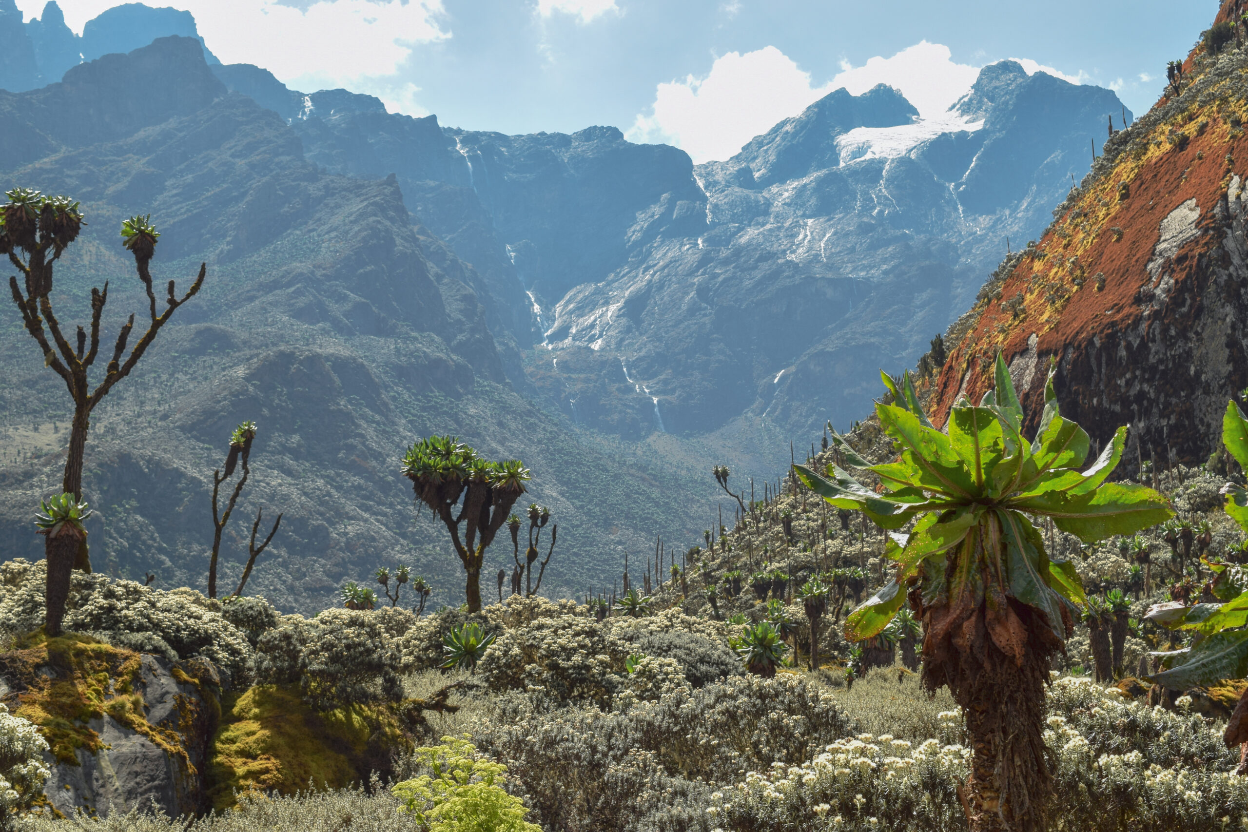
Margherita Peak — the highest of Mount Stanley’s eleven glacial summits at 5,109 m — sits in the Rwenzori Mountains National Park on the Uganda-DR Congo border. The summit climb begins from Elena Hut at 4,541 m, with the approach to that base requiring a multi-day trek through five distinct vegetation zones along either the Central Circuit Trail or the Kilembe Trail.
Unlike Kilimanjaro and Mount Kenya, Mount Stanley demands genuine technical glacier travel skills — crampons, harness, ropes, and fixed-line work on exposed sections. The Stanley Glacier and Margherita Glacier crossings, combined with rocky scrambles between them, place this peak firmly in mountaineering rather than trekking territory.
Mount Stanley Route Overview
The Rwenzori Mountains contain two recognized approach trails to Mount Stanley, with significant differences in scenery, traffic, hut infrastructure, and pricing. Both routes converge at Elena Hut at 4,541 m for the technical summit climb. Choice between trails depends on budget, traffic preference, scenic priority, and whether climbers intend to bag additional Rwenzori peaks beyond Margherita.
| Route | Operator | Distance | Days | Difficulty | Best for |
|---|---|---|---|---|---|
| Central Circuit Trail | Rwenzori Mountaineering Services | ~58 km | 5-9 days | Strenuous + technical | Classic experience, multiple huts, community-managed |
| Kilembe Trail | Rwenzori Trekking Services | Variable | 6-9 days | Strenuous + technical | Less crowded, southern peaks views |
| Combined Loop | Joint operators | Longer | 8-10 days | Strenuous + technical | Ascend one trail, descend the other |
| Six Peaks Grand | Joint operators | ~80+ km | 13-18 days | Elite technical | Stanley + Speke + Baker + Luigi + Emin + Gessi |
The 7-9 day Central Circuit format gives most climbers the best balance of acclimatization, summit success probability, and budget. The 4-day fast-track is technically available but only suitable for highly experienced acclimatized mountaineers — it leaves no margin for weather delays and creates significant altitude sickness risk. Multi-peak 10-13 day formats are excellent for serious mountaineers but add substantial cost and time.
Route 1: Central Circuit Trail (Standard)
The Central Circuit is the original route into the Rwenzori and remains the most widely used approach to Margherita Peak. Managed by Rwenzori Mountaineering Services, a community-based operator, the trail covers approximately 58 km in a loop from Nyakalengija (also called Mihunga station) through the upper valleys and back via a different return path. The route passes seven established huts including Nyabitaba, John Matte, Bujuku, Elena (the summit base), Kitandara, Guy Yeoman, and the lower Nyabitaba return camp.
Central Circuit — Classic 7-Day Margherita Ascent
Day 1: Nyakalengija (1,646 m) to Nyabitaba Hut (2,651 m). Trek begins from the park gate through dense montane forest. Watch for Rwenzori Turaco, Colobus monkeys, and listen for distant chimpanzee calls. Climb takes approximately 4-6 hours through tropical and bamboo zones to reach Nyabitaba Hut. The Kurt Shaffer Bridge crossing marks transition into the higher forest.
Day 2: Nyabitaba Hut to John Matte Hut (3,414 m). Cross the Kurt Shaffer Bridge, work through muddy terrain, then climb steep rocky areas through bamboo forest to Nyamuleju Hut at the giant lobelia and groundsel zone boundary. Continue through the Bujuku River bog to John Matte. Approximately 6 hours total. First views of snow-capped Margherita and Elena Peaks appear from the camp.
Day 3: John Matte Hut to Bujuku Hut (3,962 m). Cross Bujuku River and enter the lower Bigo Bog — a grassy bog requiring tussock-to-tussock jumping. Reach Bigo Hut and continue through upper Bigo Bog to Lake Bujuku and the alpine savannah zone. Camp at Bujuku Hut with views of Mount Stanley, Mount Baker, and Mount Speke. Hike time approximately 5 hours.
Day 4: Bujuku Hut to Elena Hut (4,541 m). Climb steep slopes west of Lake Bujuku through Groundsel Gully to Scott-Elliot Pass at 4,372 m. Final section ascends rocky terrain to Elena Hut, perched just below the Stanley Glacier. The hut serves as the summit base camp. Early dinner and rest essential before the predawn summit push.
Day 5: Summit Day — Margherita Peak (5,109 m) and descent to Kitandara Lakes (4,062 m). Departure approximately 2:00 AM with headlamps, crampons, harnesses, and ropes. Ascend onto Stanley Glacier for technical glacier hike across the Stanley Plateau. Transition to rocky scrambling before the Margherita Glacier final approach. Fixed ropes assist exposed sections to the col between Margherita and Alexandra peaks, then a short steep rock wall to the summit. Total summit day 10-12 hours including descent. Continue down through Scott-Elliot Pass with views back to Bujuku Lake, Mount Speke, and the Kitandara Lakes basin.
Day 6: Kitandara to Guy Yeoman Hut (3,505 m). Climb to Freshfield Pass at 4,282 m through long flat alpine mossy glades, then descend through rocky and boggy terrain. Panoramic views back to Stanley and Baker glaciers throughout the descent.
Day 7: Guy Yeoman Hut to Nyakalengija. Final descent through the lower forest zones back to the park gate. Approximately 6-7 hours of mostly downhill walking, returning through the bamboo and montane forest zones to the starting point.
The 7-day standard format works for most climbers but the Central Circuit accommodates 5-day fast-track and 9-day extended formats. The 5-day version compresses the approach and skips the Guy Yeoman/Kitandara descent loop — instead returning via the ascent route. The 9-day version adds rest days at Bujuku and Kitandara plus optional Mount Speke or Mount Baker side trips. Acclimatization improves significantly with each added day, particularly above 3,500 m.
Why the Central Circuit dominates climber traffic
The Central Circuit benefits from the longest operational history (managed since the 1970s), established hut infrastructure at every overnight stop, the lowest pricing (commercial expeditions from approximately USD 1,230 for 7-day group format), and the most experienced local guides — many of whom have summited Margherita 200+ times. Community-managed operation also returns trekking revenue directly to local villages around Kasese and Nyakalengija.
Central Circuit drawbacks
Higher trekker traffic during peak seasons can create congestion at huts, particularly Bujuku and Elena. The standard return loop via Kitandara, Guy Yeoman, and Freshfield Pass adds physical demand without providing technical climbing variation. Weather during the descent days can be relentlessly wet given the equatorial location combined with bog crossings.
Route 2: Kilembe Trail (Southern Approach)
The Kilembe Trail is the newer southern approach to Mount Stanley, opened by Rwenzori Trekking Services as an alternative to the established Central Circuit. The trail offers a less crowded ascent with different scenery, particularly views of Mount Baker and the southern Rwenzori peaks. The Kilembe approach also passes Weismann’s Peak and reaches the Stanley massif from a different angle, providing alternative summit-day logistics.
Kilembe Trail — Less Crowded Southern Approach
The Kilembe Trail begins at Kilembe town and ascends through tropical forest to Sine Camp on day one. The route progresses through different vegetation zones than the Central Circuit, often providing easier walking in dry conditions through tussock grass and Giant Lobelias. The first major view of Mount Stanley, Mount Baker, Weismann’s Peak, and into the DR Congo typically appears around Bamwanjara Pass.
The trail continues through Bugata Camp and onward to the high alpine region, eventually joining the route to Elena Hut for the summit attempt. Standard 8-9 day Kilembe Trail itineraries include 1-2 acclimatization days that improve summit success rates. The descent typically returns via Kitandara and Samalira Camp back to Kilembe, completing a different loop than the Central Circuit.
For mountaineers seeking views of Mount Baker — the third-highest peak in the Rwenzori — the Kilembe Trail provides much better positioning. Some itineraries combine a Mount Baker ascent with the Margherita Peak summit, leveraging the southern approach’s proximity to both peaks.
Route 3: Combined Loop (Ascend Central, Descend Kilembe)
Many experienced mountaineers prefer combining both trails to maximize variety and avoid retracing terrain. The typical combined format ascends via the Central Circuit to Elena Hut, attempts Margherita Peak, and descends via the Kilembe Trail (or vice versa). The combined approach requires logistical coordination between the two operating concessions and typically takes 8-10 days.
Combined Central + Kilembe Loop
The combined loop suits climbers who want to experience both trail networks in a single trip. Ascending via the Central Circuit provides classic hut-to-hut progression through Nyabitaba, John Matte, Bujuku, and Elena. After the Margherita summit, descend via Bugata Camp, Bamwanjara Pass, and the Kilembe Trail back to Kilembe town. The format adds approximately USD 400-800 to standard pricing due to dual concession coordination but provides significantly more varied terrain and views.
This format also accommodates the addition of Mount Speke (4,890 m) on the way up via the Central Circuit and Mount Baker (4,843 m) on the way down via the Kilembe approach, creating an efficient three-peak combination that captures the top three Rwenzori summits in a single expedition.
Route 4: Grand Six Peaks Expedition
The ultimate Rwenzori expedition targets all six major peaks in the range — Mount Stanley (5,109 m), Mount Speke (4,890 m), Mount Baker (4,843 m), Mount Emin (4,798 m), Mount Gessi (4,715 m), and Mount Luigi di Savoia (4,627 m). The 13-18 day format requires elite fitness, technical competence, and significant budget.
Six Peaks Grand Expedition
The grand expedition format combines technical glacier climbing on Mount Stanley with the rocky scrambles of Mount Speke and Mount Baker, plus the less-traveled summits of Luigi di Savoia, Emin, and Gessi. Each peak requires its own summit-day commitment, and weather days are essential planning buffer given the Rwenzori’s equatorial climate variability.
Pricing for six-peak grand expeditions typically runs USD 4,500-7,500 per person depending on group size and service level. The format is suited to climbers building toward bigger Himalayan or Andean objectives who want comprehensive East African mountaineering experience.
Route 5: 4-Day Fast-Track (Experienced Only)
The 4-day fast-track Central Circuit compresses the standard itinerary into the absolute minimum feasible timeline. This format is suitable only for highly experienced mountaineers with prior high-altitude acclimatization. The compressed schedule eliminates standard acclimatization days and leaves no margin for weather or fitness setbacks.
The 4-day Margherita format is genuinely dangerous for most climbers. The route compresses 7-day acclimatization into less than half the standard time, creating substantial acute mountain sickness risk during the summit push at 5,109 m. Operators who offer this format will require proof of prior high-altitude experience and may decline climbers without documented 4,000+ m climbs within the previous 12 months. Most expedition leaders strongly discourage this option.
Summit Day from Elena Hut — The Technical Climb
Regardless of approach trail, summit day from Elena Hut at 4,541 m to Margherita Peak at 5,109 m involves the same technical glacier and rock climbing. The standard schedule starts at approximately 2:00 AM to cross the Stanley Glacier before afternoon weather deteriorates and the ice softens dangerously.
Stage 1: Elena Hut to Stanley Glacier base (~30 minutes)
From Elena Hut, follow the trail across talus to the snout of the Stanley Glacier. This short approach allows final equipment checks — crampons fitted, harnesses adjusted, helmets on, headlamps tested. The Stanley Glacier itself begins immediately above the moraine, with crampons required from this point upward.
Stage 2: Stanley Glacier crossing and Stanley Plateau (1.5-2.5 hours)
The Stanley Glacier crossing has changed dramatically over the past century. Photographs from the 1906 Duke of Abruzzi first ascent show the glacier extending far beyond its current position, with the Stanley Plateau covered in thick ice. Climate change has driven significant retreat, exposing rock and creating crevassed sections that require careful navigation. Rope teams of 2-3 climbers are standard for the glacier crossing.
The Stanley Plateau itself remains the largest mass of ice in the Rwenzori Mountains at over a kilometer in length. The plateau crossing is straightforward roped glacier travel under good conditions but can become disorienting in cloud or whiteout. GPS coordinates and route-marking flags help guide teams across the featureless ice.
Stage 3: Rocky scramble between glaciers (~30-45 minutes)
After crossing Stanley Glacier, the route transitions onto exposed rock for a short scrambling section. Crampons typically come off here, then back on at the base of the Margherita Glacier. This intermediate section involves Class 3 scrambling on slippery rock — particularly in wet conditions, which are common given the equatorial climate.
Stage 4: Margherita Glacier ascent (1.5-2.5 hours)
The Margherita Glacier is steeper and more crevassed than the Stanley Plateau, requiring closer rope management and careful step placement. The glacier climbs to the col between Margherita Peak and Alexandra Peak (the second-highest of Mount Stanley’s summits at 5,091 m). The Uganda Wildlife Authority has installed fixed ropes and ladders on the most exposed sections.
Stage 5: Summit rock wall (~30 minutes)
From the col, a short but steep rock wall leads to Margherita’s summit. The final climbing involves Class 4 rock with fixed-rope protection. Climbers ascend using harness, ascender, and rope teamwork. The summit itself is a small platform with views — weather permitting — across the entire Rwenzori range and into the DR Congo lowlands.
Stage 6: Descent (4-5 hours)
Descent reverses the ascent route. Rappels on the summit rock wall and the steepest Margherita Glacier sections are standard. The Stanley Plateau crossing tends to be slower on descent due to accumulated fatigue and softening ice. Most teams reach Elena Hut by early afternoon, with the full summit day running 10-12 hours.
The Stanley Glacier and Margherita Glacier are receding rapidly. Photographs from the 1906 Duke of Abruzzi first ascent show massive ice walls that no longer exist in 2026. Conditions you’ll encounter today differ significantly from descriptions in even moderately recent guidebooks. The Uganda Wildlife Authority installs ladders and fixed ropes annually to manage changing conditions, but route specifics evolve year to year. Use only current operator route information for trip planning, not historical descriptions.
Best Season Timing for Mount Stanley Routes
The Rwenzori Mountains experience equatorial weather with two dry seasons and two wet seasons annually. The dry seasons run June through August and December through February, with these periods providing the highest summit success rates. However, the Rwenzori receives heavy rainfall year-round, and even peak dry season includes daily afternoon rain showers at higher elevations.
The wet seasons (March-May and September-November) see heavier sustained rainfall, deeper bog conditions on the approach trails, and slipperier rock during summit climbs. The trails remain technically open year-round, and some operators argue that wet-season trekking provides a more authentic Rwenzori experience — but summit success rates drop significantly during these months.
The 1906 Duke of Abruzzi first ascent took place in June, demonstrating the long-established preference for early dry season climbing. Most modern commercial expeditions schedule departures from late June through August or from late December through early February.
Mount Stanley Routes Frequently Asked Questions
What are the main climbing routes on Mount Stanley?
Mount Stanley climbers reach Margherita Peak via two main approach trails: the Central Circuit Trail (58 km, 5-9 days, older route managed by Rwenzori Mountaineering Services), and the Kilembe Trail (newer southern route). Both approaches converge at Elena Hut at 4,541 m, where the technical summit climb begins. The final ascent crosses the Stanley Glacier and Stanley Plateau, then climbs the steeper Margherita Glacier to reach the 5,109 m summit. Combined loop and grand expedition formats are also available.
How long does it take to climb Margherita Peak?
Standard Mount Stanley itineraries range from 4 days (fast-track Central Circuit for experienced acclimatized climbers only) to 13 days for a full six-peak expedition. The most common formats are the 7-day Central Circuit ascent and the 8-9 day combined trek incorporating other Rwenzori peaks. Summit day from Elena Hut takes 10-12 hours round trip with a 2:00 AM start.
How technical is the Margherita Peak summit climb?
The summit climb requires genuine technical glacier travel skills including crampon use, harness and rope work, and fixed-rope ascending on exposed sections. Climbers cross the Stanley Glacier, then transition to rocky scrambling before entering the Margherita Glacier. The Uganda Wildlife Authority has installed ladders and fixed ropes on exposed sections. The climb demands competence with crampons and ropes plus comfort with exposure on the col between Margherita and Alexandra peaks.
What is the Central Circuit Trail?
The Central Circuit Trail is the original and most famous route in Rwenzori Mountains National Park, covering approximately 58 km over 5-9 days. The trail starts at Nyakalengija (Mihunga station), climbs through Nyabitaba, John Matte, and Bujuku huts to Elena Hut at 4,541 m for the summit attempt. The descent returns via Scott-Elliot Pass, Kitandara Lakes, Guy Yeoman, and Freshfield Pass. The route passes through five distinct vegetation zones from montane forest to bamboo, heather, alpine moorland, and glacier.
What is the Kilembe Trail?
The Kilembe Trail is the newer southern approach to Mount Stanley. The trail offers a less crowded alternative to the Central Circuit and provides excellent views of Mount Baker and the southern Rwenzori peaks. The Kilembe approach is often combined with the Central Circuit for multi-peak expeditions, allowing climbers to ascend one route and descend the other.
Need the full Mount Stanley climbing guide?
This routes guide is part of our complete Mount Stanley climbing resource covering history, permits, costs, best season, gear, hazards, and the full expedition planning framework for Africa’s third-highest summit.
Continue your Mount Stanley research
Six companion guides cover every aspect of climbing Margherita Peak. Currently viewing the Routes Guide.