
Last updated September 24, 2026

Bald Mountain Utah Hike: Trail, Altitude & Summit Guide.
Bald Mountain is one of Utah’s most accessible true alpine summits. The trail begins at roughly 10,715 feet on the Mirror Lake Scenic Byway and climbs to an 11,943-foot summit with enormous views across western Uinta lakes and peaks. The mileage is short; the altitude, exposed terrain and mountain weather are the parts that deserve respect.
Bald Mountain at a Glance
How Hard Is the Bald Mountain Utah Hike?
Bald Mountain is one of Utah’s strongest first high-elevation summits because the route is short, maintained and nontechnical in normal dry conditions.
The Forest Service lists the trail at about 1.3 miles from Bald Mountain Pass to the summit, with roughly 1,228 feet separating the trailhead and top. That gives the hike an unusually high reward-to-distance ratio.
But easy access does not make the mountain trivial. You begin above 10,700 feet, climb almost entirely in exposed alpine terrain and finish just below 12,000 feet. Thin air, wind, lightning and rapid weather changes matter more here than the mileage suggests.
Bald Mountain Is Short, Steep and Almost Immediately Alpine.
The standard route leaves Bald Mountain Pass, climbs the broad south side of the mountain and follows a maintained trail toward the flat-topped summit. There are no long approach miles before the climbing begins.

You Step Out of the Car Into a High-Alpine Environment.
There is almost no warm-up at low elevation. Bald Mountain Pass puts hikers into thin air immediately, and the trail soon opens onto treeless terrain where weather can be seen—and felt—from a long way off.
High Uintas from Bald Mountain · Jeff McGrath / Wikimedia Commons · CC BY-SABald Mountain Trailhead & Mirror Lake Highway
The trail begins beside Utah State Route 150 near Bald Mountain Pass, approximately 29 miles east of Kamas. The road itself is seasonal and can remain closed or snow-affected well into the mountain spring.
Bald Mountain Pass → 11,943-Foot Summit
Trailhead coordinates are approximately 40.6885, -110.9040. Summit coordinates are approximately 40.6993, -110.9030. Mirror Lake sits immediately east of the mountain.
Driving the Highway Is Free. Using the Developed Recreation Site Requires a Pass.
Bald Mountain Picnic Area and Trailhead is part of the Mirror Lake Highway recreation-fee system. Forest Service fee schedules for applicable standard-amenity sites use multi-day and seasonal passes.
America the Beautiful federal recreation passes are also honored at qualifying trailhead and picnic sites. Fee amounts can change, so verify the current posted amount before driving up.

Is Bald Mountain 2.6 Miles or 4 Miles Round Trip?
Both numbers appear online. For route planning, Global Summit Guide uses the current Forest Service measurement as the primary baseline and explains the wider tourism-site number separately.
| Source / metric | Published figure | How to use it |
|---|---|---|
| U.S. Forest Service Trail #202 | 1.3 miles one way | About 2.6 miles out and back to the summit. |
| Trailhead elevation | 10,715 ft | Official Forest Service starting elevation. |
| Summit elevation | 11,943 ft | Gives approximately 1,228 feet of net elevation difference. |
| Visit Utah | 4 miles round trip / ~1,300 ft gain | A broader visitor-planning figure that may include additional walking or a different route measurement. |
| Practical planning | About 3 miles, allow extra margin | GPS tracks and exactly where you park or wander on the summit can change the final recorded distance. |
Bald Mountain Is a Beginner Summit—Not an Easy Walk.
The route avoids technical climbing in ordinary dry conditions. What makes it meaningful is how quickly it puts a newer hiker into high, exposed mountain terrain.
No Long Approach
Most major Utah summits require hours of climbing before the alpine environment arrives. Bald Mountain starts there.
The Air Is Already Thin
Someone driving directly from Utah’s valleys can feel the altitude before the first major switchback.
Weather Is Visible
The open terrain makes Bald Mountain an excellent place to learn why summit timing matters before progressing to bigger objectives.

The View Explains Why Bald Mountain Is Such a Good First Uinta Summit.
Mirror Lake, forested plateaus and a wide field of western Uinta peaks spread below the mountain. You get the visual scale of a much bigger alpine objective without spending an entire day reaching it.
Mirror Lake, Utah · Miguel del Fuego / Wikimedia Commons · CC BY-SA 4.0Bald Mountain Starts at 10,715 Feet.
That is the defining fact of this hike. You can drive from a much lower Utah valley directly to Bald Mountain Pass and begin exercising at an elevation where the reduced oxygen pressure is already noticeable.
Expect the same hiking pace to feel harder than it does at lower elevation. Slow down early instead of trying to prove that the short mileage should be easy.
Physical fitness helps with the hiking workload, but it does not guarantee that a person will tolerate altitude well. If significant headache, nausea, unusual dizziness or worsening symptoms develop, do not treat the summit as mandatory.
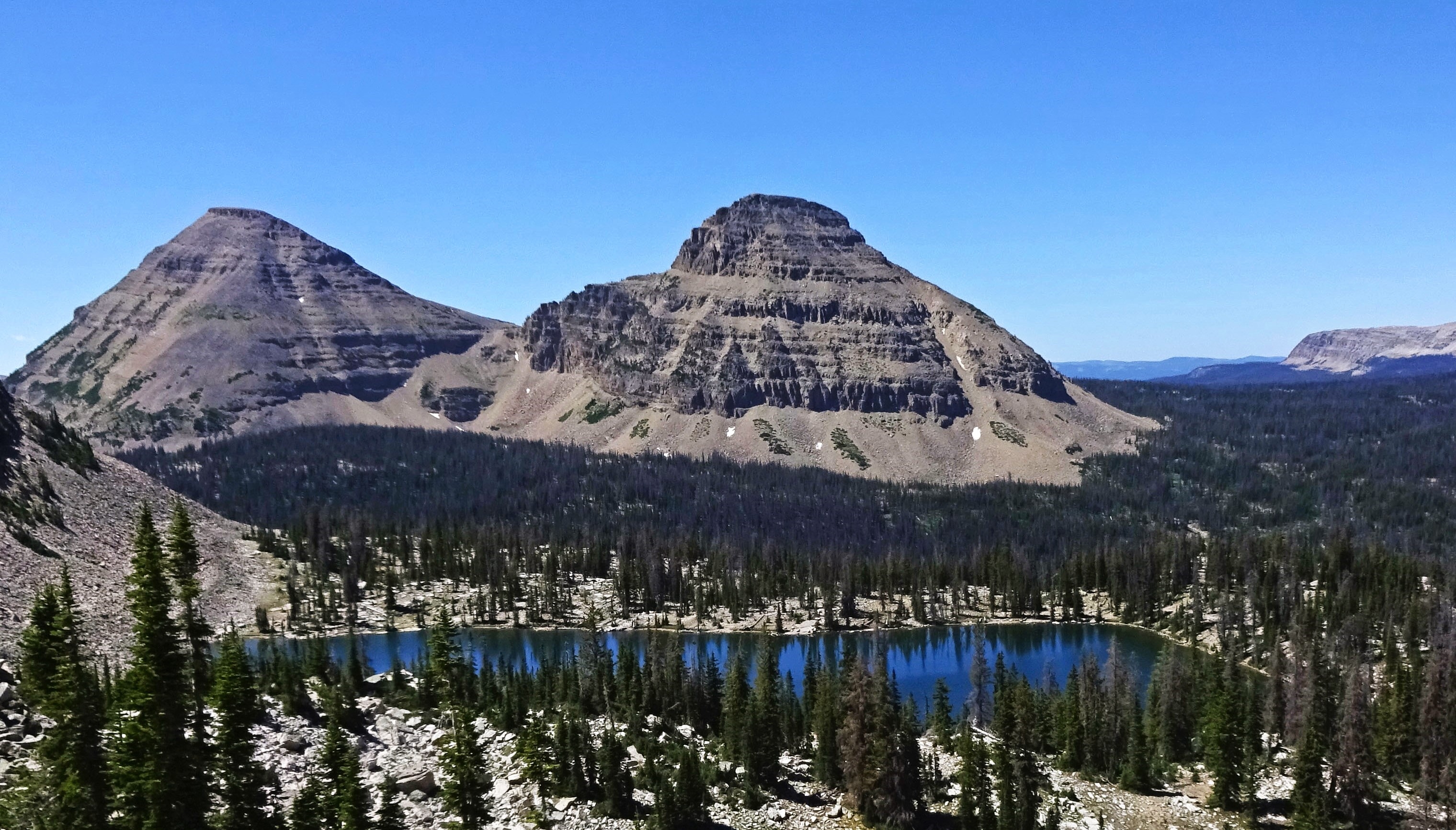
Bald Mountain Has Almost Nowhere to Hide From a Thunderstorm.
The upper mountain is open and exposed. That makes the route spectacular on a stable morning and a poor place to remain when electrical weather begins developing.
Start Earlier Than the Storm Cycle
Do not use the short mileage as an excuse for a late summer start when thunderstorms are in the forecast.
The Summit Is Fully Exposed
Wind that feels manageable in the parking area can be much more disruptive once you are above the trees.
Almost 12,000 Feet Is Still Almost 12,000 Feet
Carry a layer even when Kamas or the Wasatch Front is hot. High-elevation temperatures can be dramatically different.
Best Time to Hike Bald Mountain
Bald Mountain is primarily a summer and early-fall hiking objective. Mirror Lake Highway is seasonal, and snow can linger on the mountain after the road corridor begins opening.
Do Not Assume the Road Is Open
High-elevation snowpack controls access. Verify Highway 150 conditions before making the drive.
Early Core Season
Snow generally retreats, but lingering patches and afternoon thunderstorms can still affect the route.
Classic Bald Mountain Season
Usually the simplest trail conditions, with lightning and sun exposure still shaping the best start time.
Cooler and Excellent When Stable
Crisp conditions can be outstanding, but shorter days, freezing temperatures and early snow become more plausible.

Bald Mountain Is the Introduction. The High Uintas Are the Next Chapter.
Hayden Peak, Agassiz, Kings Peak, lake basins and the Highline Trail reveal how much larger the Uintas become once the road no longer places you directly beneath the objective.
Hayden Peak reflected in Ruth Lake · Scott Finley / Wikimedia Commons · CC BY 2.0Water, Sun & Exposure
Bald Mountain’s short duration tempts hikers to underpack. The better approach is to treat it as a compact alpine summit, not a roadside viewpoint.
Carry What You Need
Do not depend on finding drinking water on the summit trail. Start hydrated and carry your supply from the trailhead.
Very Little Shade
Once above the lower trees, the route is exposed. High-altitude sun protection matters even on a cool day.
Carry a Light Layer
A wind-resistant layer can make the difference between a pleasant summit stop and an immediate retreat.
Is Bald Mountain Good for Beginner Hikers?
It is one of Utah’s better first high summits for a reasonably fit newer hiker because the technical demands are low and the approach is short. That does not make it suitable for every first-time hiker.
Build Basic Trail Fitness
Be comfortable walking uphill for a few hours and descending rocky terrain before adding nearly 12,000-foot altitude.
Altitude + Weather Judgment
The hike adds two important mountain variables without also adding a long approach or technical scrambling.
Add Distance Before Technical Terrain
The next useful step is usually a longer mountain or overnight Uinta objective—not immediately jumping to exposed scrambling.
What to Bring on Bald Mountain
In dry summer conditions the hike does not require technical mountaineering equipment. The important gear protects against rocky footing, altitude exposure and weather change.
What We Checked Before Building This Guide
Trail mileage, road access and fees are the details most likely to conflict across Bald Mountain guides, so those receive explicit source treatment here.
Bald Mountain Utah Hiking FAQ
The most important Bald Mountain questions are really about mileage, altitude, access and whether the short hike is appropriate for a newer mountain hiker.
How long is the Bald Mountain hike in Utah?
The U.S. Forest Service lists Bald Mountain Trail #202 at 1.3 miles one way, or about 2.6 miles round trip. Some visitor sources use a broader figure of roughly four miles round trip.
How high is Bald Mountain in the Uintas?
The summit is 11,943 feet above sea level.
How much elevation does the hike gain?
Bald Mountain Pass is approximately 10,715 feet and the summit is 11,943 feet, a net difference of about 1,228 feet.
Is Bald Mountain a good beginner summit?
Yes for a reasonably fit newer hiker who understands that high altitude and exposed mountain weather are serious variables. The standard dry-season trail is maintained and nontechnical.
Do you need climbing gear for Bald Mountain?
Not in normal dry summer conditions. Standard hiking footwear, layers, water, sun protection and basic navigation are appropriate. Snow and ice can change the equipment requirement.
Where is the Bald Mountain trailhead?
The signed trailhead is at Bald Mountain Pass along Utah Highway 150, the Mirror Lake Scenic Byway, roughly 29 miles east of Kamas.
Do you have to pay to hike Bald Mountain?
The trailhead lies within the Mirror Lake Highway recreation-fee system. Current Forest Service fee schedules use multi-day and seasonal passes, and qualifying America the Beautiful passes are accepted. Verify the posted fee before your trip.
When is the best time to hike Bald Mountain?
Summer through early fall is the normal hiking season, depending on snow and Mirror Lake Highway access. July through September generally provides the strongest window.
Why does Bald Mountain feel harder than its distance?
The hike begins around 10,715 feet and climbs to nearly 12,000 feet. The altitude, rocky grade and exposed terrain can make a short route feel substantially harder than the mileage alone suggests.
What can you see from Bald Mountain?
The summit provides broad views across Mirror Lake and western Uinta lake country, with major nearby peaks including Reids Peak, Hayden Peak and Mount Agassiz visible in clear weather.
Bald Mountain Belongs Inside the Uinta Progression.
This page owns the individual Bald Mountain hiking query. The surrounding pages answer the broader questions of where to hike in the Uintas, which Utah mountain fits your trip and which first summit fits your experience.
Uinta Mountains Hiking Guide
Compare Bald Mountain with Kings Peak, alpine-lake backpacks, the Highline Trail and the larger Uinta progression.
Statewide mountain guideBest Mountains in Utah
Compare Bald Mountain with Timpanogos, Nebo, Olympus, Kings Peak and Utah’s other major objectives.
Beginner progressionBest Beginner Mountains in the USA
See where Bald Mountain fits among first summits across the Mountain West and the rest of the United States.
Prepare for Altitude, Weather & the Climb Itself.
These are the three deeper planning pages that most directly support a first high-altitude Bald Mountain attempt.
Altitude Acclimatization Explained
Understand why driving directly to a 10,715-foot trailhead is different from gradually gaining elevation on foot.
Deep Recovery · WeatherMountain Weather for Climbers
Learn how wind, temperature, precipitation and thunderstorm timing change summit decisions.
Deep Recovery · FitnessMountaineering Fitness Standards
Separate ordinary trail fitness from the endurance and reserve required for bigger objectives after Bald Mountain.
Let Bald Mountain Teach You What High Elevation Feels Like.
The summit is not important because it is one of Utah’s hardest. It is valuable because it introduces altitude, alpine weather and exposed terrain without requiring a huge approach. Finish it well, learn from the day, and then make the next mountain bigger for a reason.
Was this helpful?
Global Summit Guide is an independent mountaineering resource founded in 2026. The team combines first-hand trekking and climbing experience with in-depth research and professional health and nutrition review to help climbers choose objectives, prepare properly, and stay safe.
Health, altitude, and nutrition content is reviewed by Taylor Ludlow (Registered Nurse) and Brigg Hoopes (Nutritionist).
What We Don't Know Yet
Mountain information changes quickly. This box explains the limits of what this page can responsibly promise.
- Visa, passport, vaccination, border, insurance, and local transportation rules may change before your trip.
- Route conditions, snowpack, closures, and weather can change quickly after this page is updated.
- Permit rules, fees, quotas, and reservation windows may change between review cycles.
- Operator availability, pricing, guide ratios, and cancellation terms can change by season.
- Your fitness, altitude response, risk tolerance, and experience level may change what is safe or realistic.
Verify current conditions with official land managers, guide services, local forecasts, and current route reports before booking or climbing.
Mountaineering, rock and ice climbing, glacier travel, and high-altitude activity are inherently dangerous and can result in serious injury or death. The information on Global Summit Guide is provided for general informational and educational purposes only and is not a substitute for professional instruction, qualified guiding, proper equipment, or your own judgment and experience.
Route conditions, weather, snowpack, permits, regulations, and hazards change constantly and may differ from what is described here. Details may be incomplete, out of date, or contain errors. Always verify current information with local authorities, certified guides, and official sources before making any decision in the mountains.
Nothing on this site is medical, legal, or financial advice. Our fitness, acclimatization, altitude, and nutrition content is general in nature; consult a qualified physician before beginning any strenuous exercise program or exposing yourself to high altitude.
You are solely responsible for your own safety and decisions. To the fullest extent permitted by law, Global Summit Guide and its team accept no liability for any loss, injury, damage, or expense arising from use of, or reliance on, this information. By using this site you acknowledge these risks and accept these terms.
Some links on this site may be affiliate links. If you buy through them we may earn a small commission at no extra cost to you; this never affects our recommendations.
Global Summit Guide recommendation path
Next Best Mountain to Research
Use these recommendations to continue the right planning path instead of stopping on one page.
Use current permit, weather, route, and operator information before booking or climbing.