
Last updated September 25, 2026

Observation Point via East Mesa: Trail, Parking & Shuttle Guide.
Observation Point gives hikers a high, broad view over Zion Canyon with Angels Landing far below. The current East Mesa approach is about 6.8 miles round trip with only about 300 feet of total elevation change, but reaching the trailhead is the part that requires planning: rough dirt roads, very limited parking and weather-sensitive access.
Observation Point via East Mesa at a Glance
Is Observation Point via East Mesa Worth Hiking?
Observation Point via East Mesa is one of Zion’s strongest choices when you want a major canyon viewpoint without the chains and knife-edge character of Angels Landing.
The hike itself is comparatively gentle. Instead of climbing more than 2,000 feet from Zion Canyon, East Mesa begins high on the plateau and travels mostly through ponderosa, scrub and rolling mesa terrain before reaching the canyon rim.
The payoff arrives almost all at once: Zion Canyon opens below, Angels Landing appears far beneath the viewpoint and the scale of the main canyon becomes obvious.
The tradeoff is logistical. East Mesa is not reached from the Zion Canyon shuttle system. The direct trailhead sits beyond dirt roads where clearance, mud and limited parking can become the controlling part of the trip.
East Mesa Reaches Observation Point From Above.
The modern East Mesa route is very different from the historic climb from Weeping Rock. It begins high on Zion’s east-side plateau and approaches the rim with comparatively little net elevation change.

Most of the Approach Does Not Look Like the Famous Canyon.
East Mesa spends much of its distance on the plateau rather than beneath Zion’s towering walls. That can make the first miles feel understated—until the route reaches the rim and the entire canyon suddenly opens below.
Observation Point Trail · Fabio Achilli / Wikimedia Commons · CC BY 2.0East Mesa Trailhead to Observation Point
The important geography is easy to miss: the hike starts outside the main Zion Canyon transportation corridor and approaches the viewpoint from the east.
East Mesa Trailhead → Observation Point
East Mesa Trailhead is approximately 37.2970, -112.9001. Observation Point is approximately 37.2782, -112.9404.
Reaching East Mesa Can Be Harder Than Hiking East Mesa.
The National Park Service describes the direct East Mesa Trailhead approach as high-clearance / four-wheel-drive dirt-road access from North Fork Road.
Those roads can become extremely muddy and may be inaccessible during winter, spring or after rain. This is not a place to assume that yesterday’s road report applies after a storm.
Parking is limited to designated spaces. Nearby land includes private property, and vehicles parked illegally can be cited or towed.

The East Mesa Shuttle Can Be Easier Than Gambling on Trailhead Parking.
A commercial shuttle operates from the Zion Ponderosa area toward East Mesa. This is separate from Zion National Park’s main canyon shuttle system.
Zion Ponderosa Area
East Zion Adventures currently uses Zion Ponderosa Ranch Resort as the parking and departure base for its Observation Point shuttle.
The Shuttle Stops Short of the Trailhead
The current operator notes that shuttle passengers are dropped about half a mile from the actual trailhead. That pushes the total walking distance toward roughly eight miles round trip.
Remove the Parking Gamble
A shuttle can make sense when road conditions are questionable, your vehicle has low clearance or trailhead parking is likely to be full.

Angels Landing Is Below You—not the Destination.
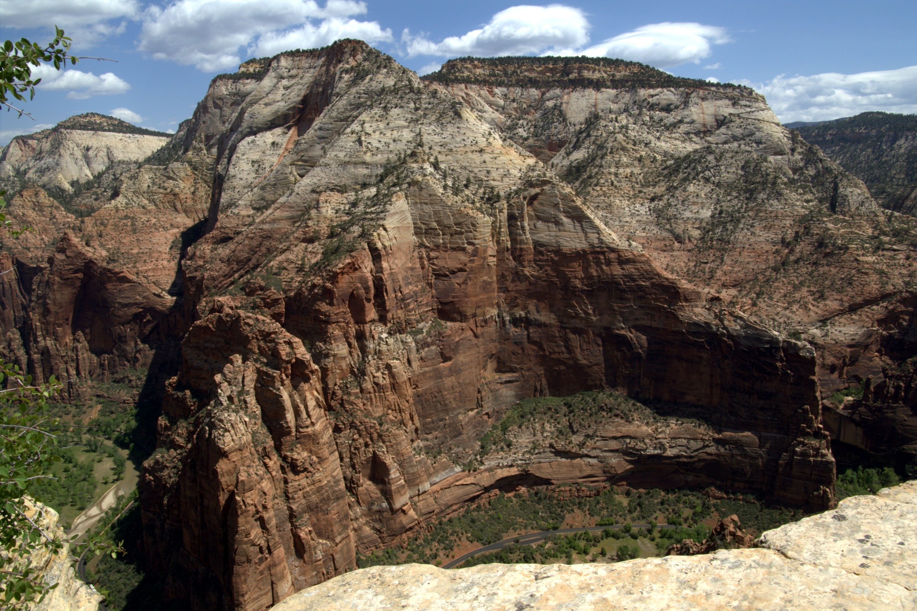
Observation Point sits high on Zion’s east rim, giving the viewpoint a very different perspective from hikes that end inside the canyon. The famous Angels Landing fin becomes one feature inside a much larger panorama.
Observation Point · Alaina McDavid / Wikimedia Commons · CC BY-SA 2.0Observation Point vs Angels Landing
These hikes should not be treated as interchangeable copies. They reach different viewpoints and create very different hiking experiences.
| Factor | Observation Point via East Mesa | Angels Landing |
|---|---|---|
| Main experience | High canyon panorama from the east rim | Narrow sandstone fin inside Zion Canyon |
| Physical character | Longer but comparatively gentle approach | Steeper climb from canyon floor |
| Chains | No chains on standard East Mesa route | Chains on final permitted section |
| Permit | No Angels Landing chains permit | Permit required beyond Scout Lookout on chains route |
| Access challenge | Dirt road, tiny parking area or commercial shuttle | Main Zion Canyon transportation system |
| Exposure | Major rim exposure at viewpoint | Sustained narrow-ridge exposure near summit |
Viewpoint-First Hikers
Choose Observation Point when the goal is a broad Zion Canyon panorama and you would rather solve access logistics than deal with a chain-assisted narrow ridge.
Hikers Seeking the Famous Ridge Experience
Angels Landing’s identity is the exposed fin and chains section. The permit, crowds and exposure are part of that route rather than incidental details.

Observation Point Changes the Scale of Angels Landing.
From inside the canyon, Angels Landing dominates the view. From the east rim, it becomes a much smaller sandstone fin surrounded by the larger walls and bends of Zion Canyon.
Angels Landing from the East Rim · J Brew / Wikimedia Commons · CC BY-SA 2.0Do You Need a Permit for Observation Point via East Mesa?
The permit people most often associate with this decision belongs to Angels Landing—not Observation Point.
No Angels Landing Permit
The Observation Point route does not use the Angels Landing chains and does not require that lottery permit.
Wilderness Permit Required
NPS requires a wilderness permit for overnight camping trips on Zion’s East Rim wilderness routes.
Keep Park Fees Separate
Zion entrance fees, private shuttle charges and wilderness permits are separate systems. Verify the ones that apply to your exact travel plan.
Weather Can Affect Both the Hike and the Drive.
Observation Point’s east-side approach has a planning issue many Zion hikes do not: precipitation can change the dirt-road access before it makes the trail itself unreasonable.
Think About the Road First
NPS warns that East Mesa access roads can become extremely muddy and inaccessible after rain. A stable hiking forecast does not help if the vehicle cannot safely reach or leave the trailhead.
Heat Still Matters
Zion can experience extreme summer heat. East Mesa begins higher than the canyon floor, but exposed portions and a dry trail still require adequate water and an appropriate start time.
Snow Changes Access
Snow, ice and freeze-thaw conditions can affect both the hiking surface and the unpaved approach roads.
When to Hike Observation Point via East Mesa
The route can be attractive across a broad part of the year, but access-road condition is unusually important compared with many paved-trailhead Zion hikes.
Comfortable Temperatures, Possible Mud
Plateau temperatures can be attractive, but wet or thawing dirt roads can make direct vehicle access poor.
Dryer Access, More Heat
Road access may be simpler when dry, but heat and summer storm development deserve an earlier hiking plan.
Strong Hiking Conditions When Dry
Cooler weather can make the plateau comfortable, with shorter daylight becoming increasingly important later in the season.
Access Can Become the Limiting Factor
Snow and mud can make East Mesa roads inaccessible or unsuitable for ordinary vehicles.
Fill Your Bottles Before Driving to East Mesa.
Zion National Park specifically notes that water filling stations are not available at the East Rim trailheads.
Do not build the day around finding reliable water on the route. Carry what the group needs for the full hike, including enough margin for heat, a delayed return or an access problem.
Dogs, Group Size & Private Property
East Mesa may feel less developed than the central canyon, but the same park and wilderness responsibilities still apply.
Not Permitted
NPS does not permit pets on Zion wilderness trails. The Pa’rus Trail is the park’s primary pet-friendly trail exception.
Maximum 12
Zion wilderness routes have a maximum group size of 12 people sharing the same affiliation.
Designated Spaces Only
Do not create roadside spaces or block access when the small East Mesa parking area is full.
Respect Property Boundaries
NPS specifically reminds hikers that private property exists near the East Mesa Trailhead.
What to Bring to Observation Point
The route does not need technical equipment in normal dry conditions. The essentials are built around heat, weather, navigation and an isolated trailhead.

Observation Point Is About Seeing Zion Canyon as a Whole.
The payoff is not a chain section, slot canyon or summit scramble. It is the geometry of Zion itself: the river corridor, sandstone walls, Angels Landing and the larger canyon system laid out below.
Zion Canyon from Observation Point trail · Kognos / Wikimedia Commons · CC BY-SA 4.0What We Verified Before Building This Guide
East Mesa is a route where old information can create a bad plan. The historic canyon-floor approach and current east-side access are not interchangeable.
Observation Point via East Mesa FAQ
Most planning mistakes happen because hikers mix current East Mesa information with the historic trail from Zion Canyon.
How long is Observation Point via East Mesa?
Zion National Park lists the route from the actual East Mesa Trailhead at 6.8 miles round trip.
How much elevation gain is Observation Point via East Mesa?
NPS lists about 300 feet of elevation change for the East Mesa route to Observation Point and back.
How long does the Observation Point hike take?
NPS estimates about three hours from the actual East Mesa Trailhead. Add time for photos, breaks and any additional walking required by shuttle access.
Can you still hike to Observation Point?
Yes, from Zion’s east side. The historic connection from Weeping Rock through Echo Canyon remains closed because of major rockfall damage.
Do you need a permit for Observation Point?
The East Mesa day hike does not use the Angels Landing chains permit. Overnight wilderness travel requires the appropriate Zion wilderness permit.
Do you need 4WD for East Mesa Trailhead?
NPS describes the trailhead roads as high-clearance / four-wheel-drive dirt-road access. Conditions can become extremely muddy after rain and during winter or spring.
Is there parking at East Mesa Trailhead?
Yes, but designated parking is very limited. Do not park on nearby private property or create unauthorized roadside spaces.
Is there a shuttle to Observation Point?
A commercial East Mesa shuttle currently operates from the Zion Ponderosa area. It is separate from the Zion Canyon national-park shuttle.
Is Observation Point easier than Angels Landing?
East Mesa has substantially less climbing and does not use the Angels Landing chains, but it is longer and has more complicated trailhead access. The experiences are different rather than simply harder and easier versions of the same hike.
Are dogs allowed on East Mesa Trail?
No. Zion National Park does not allow pets on its wilderness trails. The Pa’rus Trail is the park’s main pet-friendly trail.
Put Observation Point Into the Right Zion Trip.
Observation Point owns the exact East Mesa route. The parent pages should answer the broader questions of which Zion hike or Utah hike belongs in the itinerary.
Zion National Park Hiking Guide
Compare Observation Point with Angels Landing, The Narrows, the Subway and Zion’s other major hiking objectives.
State hiking parentBest Hikes in Utah
Compare Zion with Bryce, the Uintas, the Wasatch, Moab and Utah’s other major hiking regions.
Key Zion comparisonAngels Landing Hiking Guide
Compare the East Mesa panorama with Zion’s famous chains-and-ridge experience.
Access, Weather & the Larger Trip Plan
These are the three deeper GSG resources that most directly support an East Mesa day.
Trailhead Finder & Access Planner
Build the parking, shuttle and road-access plan before the morning of the hike.
Deep Recovery · WeatherMountain Weather for Climbers
Read precipitation, storm timing, temperature and changing conditions rather than checking only a generic Zion forecast.
Deep Recovery · Trip PlanningMountain Trip Planning
Connect access, timing, transport, weather and backup plans into the larger Utah trip rather than treating the hike alone.
Observation Point Is Easy to Understand Once You Separate the Hike From the Access.
The trail is a moderate plateau walk to one of Zion’s largest canyon views. The planning challenge is getting to East Mesa legally and reliably. Check the road, decide whether to drive or shuttle, carry your water and then let the viewpoint be the complicated part of the scenery.
Was this helpful?
Global Summit Guide is an independent mountaineering resource founded in 2026. The team combines first-hand trekking and climbing experience with in-depth research and professional health and nutrition review to help climbers choose objectives, prepare properly, and stay safe.
Health, altitude, and nutrition content is reviewed by Taylor Ludlow (Registered Nurse) and Brigg Hoopes (Nutritionist).
What We Don't Know Yet
Mountain information changes quickly. This box explains the limits of what this page can responsibly promise.
- Visa, passport, vaccination, border, insurance, and local transportation rules may change before your trip.
- Route conditions, snowpack, closures, and weather can change quickly after this page is updated.
- Permit rules, fees, quotas, and reservation windows may change between review cycles.
- Operator availability, pricing, guide ratios, and cancellation terms can change by season.
- Your fitness, altitude response, risk tolerance, and experience level may change what is safe or realistic.
Verify current conditions with official land managers, guide services, local forecasts, and current route reports before booking or climbing.
Mountaineering, rock and ice climbing, glacier travel, and high-altitude activity are inherently dangerous and can result in serious injury or death. The information on Global Summit Guide is provided for general informational and educational purposes only and is not a substitute for professional instruction, qualified guiding, proper equipment, or your own judgment and experience.
Route conditions, weather, snowpack, permits, regulations, and hazards change constantly and may differ from what is described here. Details may be incomplete, out of date, or contain errors. Always verify current information with local authorities, certified guides, and official sources before making any decision in the mountains.
Nothing on this site is medical, legal, or financial advice. Our fitness, acclimatization, altitude, and nutrition content is general in nature; consult a qualified physician before beginning any strenuous exercise program or exposing yourself to high altitude.
You are solely responsible for your own safety and decisions. To the fullest extent permitted by law, Global Summit Guide and its team accept no liability for any loss, injury, damage, or expense arising from use of, or reliance on, this information. By using this site you acknowledge these risks and accept these terms.
Some links on this site may be affiliate links. If you buy through them we may earn a small commission at no extra cost to you; this never affects our recommendations.
Global Summit Guide recommendation path
Next Best Mountain to Research
Use these recommendations to continue the right planning path instead of stopping on one page.
Use current permit, weather, route, and operator information before booking or climbing.