Last updated November 2, 2026
Mount Shuksan: routes, permits & the summit pyramid.
One of Washington’s most photographed mountains is also a real alpine climb. Compare the Sulphide Glacier and Fisher Chimneys routes, understand the rock finish, and plan your 2027 permit.
Summit: about 9,131 ft (2,783 m). This is not a hiking trail to a summit viewpoint: roped glacier travel, snow skills, navigation, and exposed rock are central to the climbing routes.
Independently researched · November 2026 · Verify current NPS conditions before departure.

What does it take to climb Mount Shuksan?
Climb Shuksan via the Sulphide Glacier for the more approachable standard alpine line; choose Fisher Chimneys only when your party has the route-finding, rock, steep-snow, and glacier experience to handle a more intricate climb. Both usually lead to the same exposed summit pyramid.
Calling Sulphide the “easier” route does not make it a beginner day hike. Even on the standard route, climbers should expect crevasse exposure and the potential need to rope up, belay, downclimb or rappel from the summit rock. Conditions change with temperature, snowpack and freeze–thaw cycles.
Most guided programs take three or four days, while very fit and experienced teams sometimes move faster. Your real route, camp position, snow bridges and summit conditions determine the time required.

Sulphide Glacier vs Fisher Chimneys vs North Face
Compare routes by technical commitment—not simply by total mileage or the lowest published grade. Weather, snow bridges, and blue ice can turn the same named line into a very different climb.
| Route | Entry / ascent | Terrain | Good fit | Key hazard |
|---|---|---|---|---|
| Sulphide Glacier | Shannon Ridge / Baker Lake Road side | Long approach, moderate glacier terrain, then class 3–4 summit rock; protection may be needed | Rope-competent glacier teams; guided climbers learning technical alpine travel | Crevasses, hidden snow bridges, rockfall and descent |
| Fisher Chimneys | Lake Ann / Mount Baker Highway | Class 3–4 scrambling, steep Winnie’s Slide, Curtis Glacier, Hell’s Highway, final pyramid | Experienced alpinists with strong snow and rock judgment | Route-finding, exposed rock, late-season blue ice |
| North Face | North-side technical approach; route dependent | Serious ice/snow and mixed alpine climbing | Advanced, self-sufficient technical parties | Objective danger and demanding retreat |
| White Salmon Glacier | Mount Baker Highway side | More involved glacier approach; conditions vary widely | Experienced glacier climbers | Crevasses and complicated route selection |
Sulphide Glacier
Best route to consider when your team wants a logical glacier ascent and a separate rock finish. The Shannon Ridge approach gains thousands of feet before camp.
See route stages →Fisher Chimneys
Longer technical sequence with chimneys, Winnie’s Slide, upper Curtis Glacier and Hell’s Highway. More commitment than Sulphide.
Understand the cruxes →Picture Lake and Artist Point
See Shuksan’s most famous profile without attempting the glaciers. These roadside viewpoints are different destinations.
Plan a scenic visit →Sulphide Glacier: approach, camp and summit
1. Shannon Ridge approach
Travel to the Shannon Ridge trailhead using Baker Lake Road and Forest Road access. These roads may be rough or blocked by snow and storm damage; review current Forest Service notices rather than relying on an old route-track start point. The approach climbs steep forest, then reaches open ridge and alpine terrain.
2. Choose a durable alpine camp
Mountaineers route descriptions commonly place camps on or near the ridge and glacier approach, sometimes around 5,400–6,400 feet depending on season. Select the exact site using the permitted cross-country zone and current terrain. Do not pitch tents on fragile heather. Snow camping and melting snow for water may be necessary.
3. Rope up for the Sulphide
The upper glacier appears gently angled in photos, but has crevasses and weak snow bridges. Use an appropriate roped system, carry a crevasse-rescue kit, and select a line using current information rather than blindly following boot tracks.
4. Assess the rock pyramid separately
The classic finish ascends the summit pyramid via a rock gully or other selected line. A dry day can bring exposed scrambling and rope handling; snow or ice may require different protection or may warrant turning around. Plan enough time and equipment for a protected descent.

Fisher Chimneys: four decisions that define the climb
Fisher Chimneys links exposed scrambling with steep snow and crevassed glacier terrain. Each of the four sections changes the skills, equipment and turnaround choices your team needs. Use a current, detailed climbing topo and recent conditions for actual navigation.
Lake Ann: locate the correct line
Reach the Lake Ann approach from the Artist Point/Austin Pass side of State Route 542 when the road is open. Lingering snow can obscure the trail and route-finding before the chimneys. Allow extra time if seasonal road closures lengthen the approach.
Fisher Chimneys: manage exposed scrambling
The chimneys involve sustained class 3–4 scrambling on consequential terrain. A wrong turn can lead to loose, steep rock. Helmets, spacing, sound route-finding and the ability to protect or retreat from exposed moves matter.
Winnie’s Slide and Upper Curtis Glacier
A steep snow or ice step leads toward crevassed Upper Curtis Glacier travel. Seasonal melt can expose hard blue ice. Match protection, rope techniques and crevasse-rescue readiness to actual conditions—not to a summer trip report.
Hell’s Highway and the summit pyramid
Another steep snow or ice passage connects toward the upper Sulphide-side terrain. Assess the summit rock separately, and reserve time and protection for the descent. A climbable ascent does not guarantee an easy or safe return.
The summit pyramid: why many climbers turn around
The broad glacier approach can create an illusion that the day’s hardest work is finished. The last several hundred feet of Shuksan are much steeper and more exposed than the upper glacier. Even climbers who are comfortable on a glacier may not be comfortable climbing the rock gully or reversing those moves.
Expect route-dependent class 3–4 terrain, with harder moves possible. In early season, snow may fill gullies. Later in summer, mixed ice, loose rock and other parties above you can increase risk. Carry the rope, protection and experience required for the conditions—not only for the nominal grade.
Turn around when any of these are true
- The gully has hard ice or fresh snow that your party cannot protect safely.
- Your team lacks the ability to belay, downclimb or rappel the chosen descent.
- Afternoon weather, lightning, deteriorating visibility or fatigue threatens the return.
- The glacier’s snow bridges are weakening and your schedule leaves no margin.
Successful trip planning means reserving enough time to descend, not merely reaching the summit.

Mount Shuksan climbing permits and 2027 reservation dates
Overnight trips in North Cascades National Park require a backcountry permit. A reservation is not itself the final issued permit. Sulphide Glacier is one of the high-demand cross-country zones that accepts advance reservations; other zones, including route-relevant areas, can operate on walk-up allocations. Select the actual route and camp zone before booking.
| 2027 milestone | Official NPS date | What it means |
|---|---|---|
| Lottery applications | March 1–12 | Apply for early reservation access; deadline 9 p.m. Pacific on March 12. |
| Lottery results | March 19 | Successful applicants receive reservation time slots. |
| Lottery booking window | March 23–April 20 | Lottery winners may reserve during or after their allocated time. |
| General reservations | April 29, 7 a.m. PT | Remaining advance-reservable inventory goes on sale. |
| Peak season WIC | May 14–October 9 | 2027 Wilderness Information Center peak-season operating dates. |
Current NPS fee schedule: $10 per person age 16+, children 15 and younger free, plus a $6 nonrefundable reservation fee. Fees and policies may change; verify in the booking flow.
1 · Identify the camp zone
Match your planned route to the park’s actual zone. Sulphide Glacier and Fisher Chimneys are not the same access corridor; confirm which zone is appropriate with rangers.
2 · Reserve or request walk-up
Reserve via Recreation.gov for eligible advance zones. NPS also describes walk-up and limited email options. Availability is never guaranteed.
3 · Obtain the issued permit
Follow the required permit issuance or pickup instructions exactly. Advance reservations must generally be converted to issued permits by the published deadline.
4 · Follow campsite and waste rules
Cross-country camping is on snow, rock or bare durable surfaces, not vegetation. Pack out human waste when necessary, and follow all party-size rules.
Trailheads, roads, parking and season
Sulphide: Shannon Ridge trailhead
Approach from the Baker Lake Road area, reached from SR 20, using the Shannon Ridge / Forest Road 1152 corridor. Trailhead roads are often rough and vulnerable to washouts; verify open roads with Mount Baker–Snoqualmie National Forest before driving.
Fisher: Mount Baker Highway and Lake Ann
Approach via SR 542 east of Bellingham toward Heather Meadows, Austin Pass and Artist Point when seasonal road access permits. Snow closure near Artist Point can extend the walk. Check Washington DOT and Forest Service notices before relying on a mapped trailhead pin.
Best season
Many guided ascents run from late spring through September. Mid-summer often offers a practical tradeoff between approach snow and late-season exposed ice, but there is no universally “safe” month. Check NPS mountain-specific climbing reports and weather in the final days before climbing.
Parking passes on Forest Service approaches may be required independently of park camping permits; follow the current trailhead signs and land-manager guidance.

A practical three-day Mount Shuksan plan
Approach and establish camp
Confirm trailhead road access, hike to durable permitted camp, filter or melt water, review glacier conditions and rope systems. Avoid arriving exhausted.
Glacier, pyramid and descent
Leave before dawn if conditions warrant; travel roped, assess crevasses, inspect summit-rock conditions, climb only if protectable, descend with ample daylight.
Pack camp and return
Descend the approach with care, especially if wet or snow-covered. Keep weather and travel contingencies; do not assume a three-day calendar guarantees a summit.
Skills, gear and rescue preparedness
Required skills
Competent independent climbers need real experience with glacier rope teams, crevasse rescue, navigation, ice-axe arrest, crampons, snow/ice protection, rock belays and rappels or other protected descents. On Fisher Chimneys, add exposed scrambling and complex rock/ice route finding.
Core equipment to plan for
- Mountaineering boots, compatible crampons, helmet and ice axe.
- Rope, harness, prusiks/ascending systems and full crevasse-rescue kit selected by the team.
- Route-specific belay/rappel and snow/ice protection, adjusted to current conditions.
- Offline topographic maps, navigation tools, emergency communication and headlamps.
- Insulation, waterproof layers, glacier sun protection and reliable stove/water treatment.
- Durable campsite setup and approved human-waste packing supplies.
Training benchmark
Arrive prepared to carry expedition camping gear uphill for several hours, then execute a long technical summit day the following morning. A guided climb may be an appropriate place to learn, but the program’s prerequisites and curriculum vary; do not interpret marketing terms such as “beginner” to mean nontechnical.
How much does climbing Mount Shuksan cost?
For independent teams the park permit is relatively inexpensive, while travel, personal technical equipment and training make up most of the cost. Guided quotes vary by course length, group ratio and included instruction; use current operator pages rather than generalized price averages.
| Cost item | 2026–27 published example | Read before booking |
|---|---|---|
| NPS overnight backcountry fee | $10 per adult age 16+ plus $6 reservation fee | Per-person recreation fee and per-reservation charge; subject to change. |
| American Alpine Institute | 2027 three-day Sulphide $1,265; four-day $1,480 | Different training days and prerequisites; see current program. |
| Alpine Ascents International | 2027 four-day Sulphide $2,150 | Includes instruction/group gear; exclusions vary. |
| Northwest Alpine Guides | 2027 three-day $1,300; four-day $1,700 | Published schedule may change; verify gear and permit terms. |
| Independent climbing | Highly variable | Training, gear purchase/rental, food, transport, parking and lodging. |
Guide prices are publicly advertised examples, not quotes from GSG, endorsements or sponsored rankings. No booking availability has been checked. Prices and inclusions can change.
Can you see Mount Shuksan without climbing?
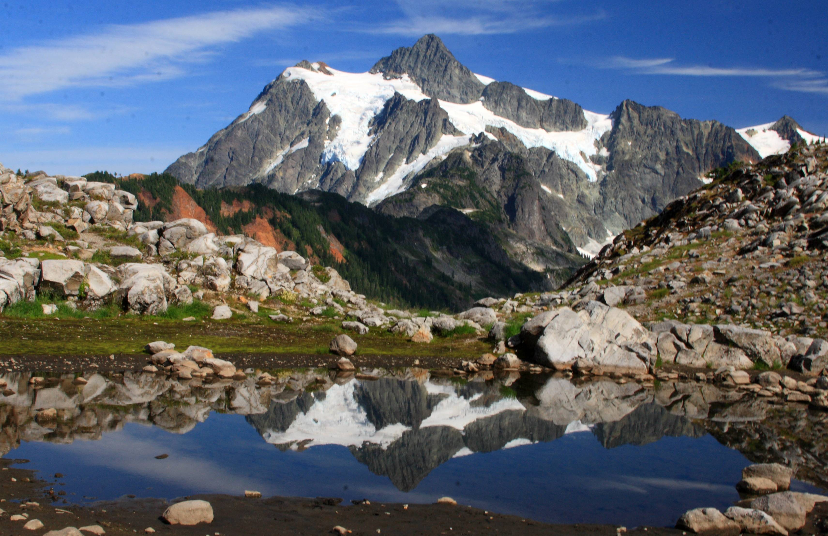
Yes. Picture Lake and the Artist Point / Heather Meadows area offer some of the best nontechnical Mount Shuksan views in Washington. The iconic lake-reflection photograph is from a roadside visitor area, not from Shuksan’s summit route. These scenic stops are an ideal option for photographers, families, or climbers on a poor-weather day.
Picture Lake
Drive the Mount Baker Highway (SR 542) toward Heather Meadows when open. Look for the short viewpoint walk and interpretive signs. Protect sensitive shoreline vegetation and stay on maintained routes. Fall reflections can be beautiful, but there is no guarantee of windless water.
Artist Point
Above Heather Meadows, the Artist Point road is seasonally snowbound and usually closes well before winter. The public overlooks can frame both Mount Shuksan and Mount Baker; check access first.
Seeing these views requires no glacier ropes, but snow and ice on walkways can still make conditions hazardous.

Weather, crevasses and the seasonal hazard shift
Shuksan sits in the wet, maritime North Cascades. Glacier travel depends on both the previous winter’s snowpack and recent weather. Early-season snow can conceal crevasses; late-season heat can uncover ice and weaken bridges. Even in August, fresh snow, clouds and freezing temperatures can change the route.
Before you leave home
Check NPS Shuksan climbing conditions, the Northwest Avalanche Center when snow conditions warrant, current Forest Service road alerts, and mountain-specific forecasts.
At camp
Examine temperatures, the freezing level, overnight refreeze, wind, precipitation and expected afternoon cloud formation. Reassess the camp’s water situation.
On summit morning
Monitor snow bridges and turnaround time, then assess pyramid rock separately. If you cannot descend the route safely, the correct decision is not to summit.
Read route-specific ranger updates · Learn to interpret mountain weather
Mount Shuksan climbing FAQ
Answers reference the official National Park Service, The Mountaineers and current operator route information. Conditions are not static.
How high is Mount Shuksan?
The summit is commonly listed around 9,131 feet (2,783 metres); some older route descriptions use 9,127 feet.
Can beginners climb Mount Shuksan?
Strong hikers new to glacier climbing may be appropriate for an instructional guided Sulphide Glacier program, but it is not a novice hiking summit. Verify a program’s prerequisites.
What is the easiest Mount Shuksan route?
Sulphide Glacier is generally considered the more approachable popular route. It still requires glacier ropework and a technical summit-pyramid finish.
Is Mount Shuksan a hike or a climb?
The summit is a mountaineering climb. Picture Lake and Artist Point are separate scenic hiking and viewing options.
What are Fisher Chimneys?
A series of exposed rock-scrambling passages on Shuksan’s north-side route, followed by steep snow, glacier travel and the summit pyramid.
Are Sulphide Glacier and Fisher Chimneys the same route?
No. They use different approaches and different technical sections, although they usually converge near the summit pyramid.
How long does a Mount Shuksan climb take?
A two- to four-day schedule is common, depending on skills, weather and whether a guided course includes training; many guided trips run three or four days.
Does Mount Shuksan require a permit?
Overnight camping in North Cascades National Park requires a backcountry permit. Confirm any route-specific and land-manager requirements with park rangers.
When does the 2027 backcountry lottery open?
The NPS lists March 1–12, 2027 for early-access applications; the general advance sale opens April 29, 2027 at 7 a.m. Pacific.
Does reserving a campsite mean I have a permit?
No. An advance reservation must be converted to the issued permit under NPS rules; check pickup or issuance instructions and deadlines.
Can I get a walk-up permit for Shuksan?
NPS maintains walk-up permit inventory and describes limited email requests for certain corridors. Availability is not guaranteed; check the route’s actual cross-country zone.
How hard is the summit pyramid?
Common descriptions range from class 3 to class 4 and occasional harder rock moves depending on the line, conditions and protection selected. Snow or ice can increase difficulty significantly.
Can I climb the summit pyramid without a rope?
That is not a sensible default assumption. Teams should have the skills and equipment to protect exposed climbing and descend safely, or turn around.
Is there a glacier on Mount Shuksan?
Yes. The Sulphide, Upper Curtis, White Salmon, Price and other glaciers shape its climbing routes.
When is the best time to climb Mount Shuksan?
Many climbers choose summer, especially July and August, but crevasses and ice conditions vary each year. NPS climbing reports are more useful than a fixed ideal month.
Do you need crevasse-rescue skills?
Yes for independent glacier travel. Climbers must know how to manage rope teams, arrest falls and respond to crevasse incidents.
Where is the Sulphide Glacier trailhead?
It approaches from the Shannon Ridge area off the Baker Lake Road network, east of the North Cascades. Verify Forest Road 1152 and trailhead access.
Where does Fisher Chimneys start?
The approach generally starts from the Lake Ann/Austin Pass side of the Mount Baker Highway near Heather Meadows; access changes with seasonal road opening.
Can I camp anywhere on Shuksan?
No. Camping must follow the issued park permit and cross-country zone rules. Use durable snow, rock or bare ground, not fragile heather and meadow vegetation.
Are dogs allowed on the climbing routes?
Pets are not allowed in North Cascades National Park wilderness. Confirm exact jurisdiction on any approach trails and keep pets off technical climbing routes.
Is Picture Lake on the climbing route?
No. Picture Lake is a roadside scenic destination near Mount Baker Highway with a famous view of Mount Shuksan.
What should I do if the summit gully is icy?
Stop and assess whether the team can climb and descend it safely with appropriate protection. If not, turn around; NPS route reports describe late-season ice hazards.
Sources to check immediately before climbing
Park permits
This is a researched trip-planning article, not a firsthand report or a turn-by-turn technical climbing topo. Verify permit rules, conditions and land-manager road notices before departure.
Explore related GSG climbs and peak collections
Mountains of the world
Find Mount Shuksan (#236) in the Global Summit Guide mountain collection and browse more alpine objectives.
Browse the mountain hub →Mountains in America
Compare the North Cascades with other North American ranges, elevations and trip styles.
Explore U.S. mountain ranges →Mount Shuksan expedition notes
Read the published GSG route overview and current-condition interpretation for the Sulphide and Fisher routes.
Read Shuksan expedition update →Next useful steps: 500 Mountains master list · Mountain weather · Mountaineering gloves guide.
The mountain is unforgettable. So is the descent.
Choose your route honestly, protect the glacier and alpine terrain, and give your team permission to turn around when conditions demand it.
Explore the next peak →Was this helpful?
🏔Related peaks nearby
🧭Explore & compare
Global Summit Guide is an independent mountaineering resource founded in 2026. The team combines first-hand trekking and climbing experience with in-depth research and professional health and nutrition review to help climbers choose objectives, prepare properly, and stay safe.
Health, altitude, and nutrition content is reviewed by Taylor Ludlow (Registered Nurse) and Brigg Hoopes (Nutritionist).
What We Don't Know Yet
Mountain information changes quickly. This box explains the limits of what this page can responsibly promise.
- Permit availability, reservation windows, quotas, and official fee rules may change after this page is updated.
- Route conditions, trailhead access, crevasse exposure, stream crossings, and rescue access may vary from published planning guidance.
- Visa, passport, vaccination, border, insurance, and local transportation rules may change before your trip.
Verify current conditions with official land managers, guide services, local forecasts, and current route reports before booking or climbing.
Mountaineering, rock and ice climbing, glacier travel, and high-altitude activity are inherently dangerous and can result in serious injury or death. The information on Global Summit Guide is provided for general informational and educational purposes only and is not a substitute for professional instruction, qualified guiding, proper equipment, or your own judgment and experience.
Route conditions, weather, snowpack, permits, regulations, and hazards change constantly and may differ from what is described here. Details may be incomplete, out of date, or contain errors. Always verify current information with local authorities, certified guides, and official sources before making any decision in the mountains.
Nothing on this site is medical, legal, or financial advice. Our fitness, acclimatization, altitude, and nutrition content is general in nature; consult a qualified physician before beginning any strenuous exercise program or exposing yourself to high altitude.
You are solely responsible for your own safety and decisions. To the fullest extent permitted by law, Global Summit Guide and its team accept no liability for any loss, injury, damage, or expense arising from use of, or reliance on, this information. By using this site you acknowledge these risks and accept these terms.
Some links on this site may be affiliate links. If you buy through them we may earn a small commission at no extra cost to you; this never affects our recommendations.
Global Summit Guide recommendation path
Next Best Mountain to Research
Use these recommendations to continue the right planning path instead of stopping on one page.
Use current permit, weather, route, and operator information before booking or climbing.