
Last updated September 28, 2026

Licancabur Climbing Guide: Bolivia Route, Altitude, Season & Cost
Licancabur is one of the most recognizable volcanic cones in the Central Andes. The mountain rises directly above Laguna Verde on the Bolivia–Chile border, but the established climbing route approaches from Bolivia: a steep, non-glaciated ascent following the northeast side toward a summit crater containing archaeological remains and one of the world’s highest perennial crater lakes.
How Hard Is Licancabur?
Licancabur is technically straightforward but physically serious. Andeshandbook currently grades the northeast route “Algo Difícil,” with the physical component much higher than its technical or exposure scores. The route is largely steep volcanic walking rather than glacier climbing.
The real challenge is the combination of a summit near 5,900 meters, approximately 1,320 meters of elevation gain from the upper approach, very cold pre-dawn temperatures and a summit day that recent teams have reported at roughly seven to eight hours up plus three or more hours down.
A Perfect Cone on an International Border.
Licancabur rises directly on the Bolivia–Chile frontier at the southern edge of Bolivia’s high-altitude Sud Lípez landscape. Its symmetry, isolation and visibility from San Pedro de Atacama make it one of the defining mountains of the Atacama region.
High-Altitude Stratovolcano
The Smithsonian Global Volcanism Program classifies Licancabur as a stratovolcano constructed largely during the Holocene, with younger lava flows extending down its flanks.
Steep High-Altitude Trek
The normal northeast route normally requires endurance, cold-weather preparation and altitude judgment more than rope systems or technical climbing.
Crater, Lake & Ruins
Licancabur’s summit crater contains a small lake and archaeological remains documenting the mountain’s importance long before modern mountaineering.
Andeshandbook uses 5,916 m from Chilean IGM mapping, and the Smithsonian Global Volcanism Program also describes the crater rim at 5,916 m. Other tourism sources sometimes round the volcano to 5,920 m or use slightly higher figures.

Laguna Verde Is Where the Climb Becomes Real.
Most climbing logistics are organized around the Laguna Verde and Laguna Blanca sector inside Bolivia’s Eduardo Avaroa protected area. The established northeast ascent starts high, but the summit still sits more than a vertical kilometer above the upper vehicle approach.
Madeleine Deaton · CC BY 2.0 · Wikimedia CommonsThe Established Route Climbs From Bolivia.
Andeshandbook’s March 2026 route record describes the northeast route as a clear and marked ascent beginning from the Bolivian side near the old Licancabur settlement remains.
| Route factor | Current planning figure | What it means |
|---|---|---|
| Route | Northeast / Inca Route | The established Bolivia-side ascent. |
| Walking start | ~4,620 m | You begin extremely high; prior acclimatization matters. |
| Vertical gain | ~1,320 m | Large continuous gain at altitude. |
| Trail | Clear / marked | Navigation is not usually the main crux in normal dry conditions. |
| March 2026 report | ~7 h up / ~3 h down | A full high-altitude summit day even for successful climbers. |
| November 2024 report | ~8 h up / 3½ h down | Confirms that the route is physically much larger than its technical grade suggests. |
Andeshandbook’s current ratings place physical difficulty at 4.8/7, compared with technical difficulty at 2.2/7 and exposure at 2.7/7. That is an unusually clear signal that Licancabur should be planned primarily around altitude, endurance and cold rather than technical climbing prowess.

The Most Familiar View Is From Chile. The Climb Is Normally From Bolivia.
Licancabur dominates the eastern skyline from San Pedro de Atacama, which is why many climbers begin their logistics in Chile. The actual established summit route, however, crosses the international border and approaches the volcano from Laguna Verde in Bolivia.
Entropy1963 · Public Domain · Wikimedia CommonsPlan Licancabur as a Bolivia Climb With Chilean Gateway Logistics.
Many programs begin in San Pedro de Atacama, cross at Hito Cajón and continue into Bolivia toward Laguna Verde and the Eduardo Avaroa reserve.
San Pedro de Atacama
San Pedro offers the easiest concentration of hotels, transport, acclimatization hikes, volcano guides and cross-border logistics.
Hito Cajón
The normal approach crosses out of Chile and into Bolivia near Portezuelo/Hito Cajón. Carry the travel documents required for your nationality and confirm current border operating procedures before departure.
Eduardo Avaroa Reserve
Current commercial programs and Andeshandbook use the Laguna Verde sector of Bolivia’s Eduardo Avaroa reserve as the protected-area gateway to the climb.
Current San Pedro operator guidance says the Chilean slope remains closed to civilian climbing because of legacy anti-personnel mine risk, while established commercial ascents use Bolivia. Treat the Chilean flank as closed unless competent Chilean authorities explicitly confirm legal and safe access for your exact route.
Licancabur Is a Mountain Where Paperwork Is Part of the Route.
The summit sits on an international frontier. A climb starting in Chile but ascending through Bolivia involves border formalities, protected-area entry and remote 4×4 logistics before the walking begins.
Bs150 Is the Current Published Example
Andeshandbook’s March 2026 route record describes a Bs150 entry charge for the Reserva Nacional de Fauna Andina Eduardo Avaroa. A current 2026 commercial program also explicitly includes the same Bs150 reserve ticket.
Reconfirm the fee before travel because protected-area tariffs can change.
Verify the Current Requirement
Current commercial products use local guides, and one current Bolivia operator explicitly states a local Licancabur guide is required and prices that guide separately.
We did not find a current official online SERNAP regulation clearly establishing a universal guide mandate for every ascent, so confirm the rule directly with the reserve or your operator rather than relying on old independent-climber reports.
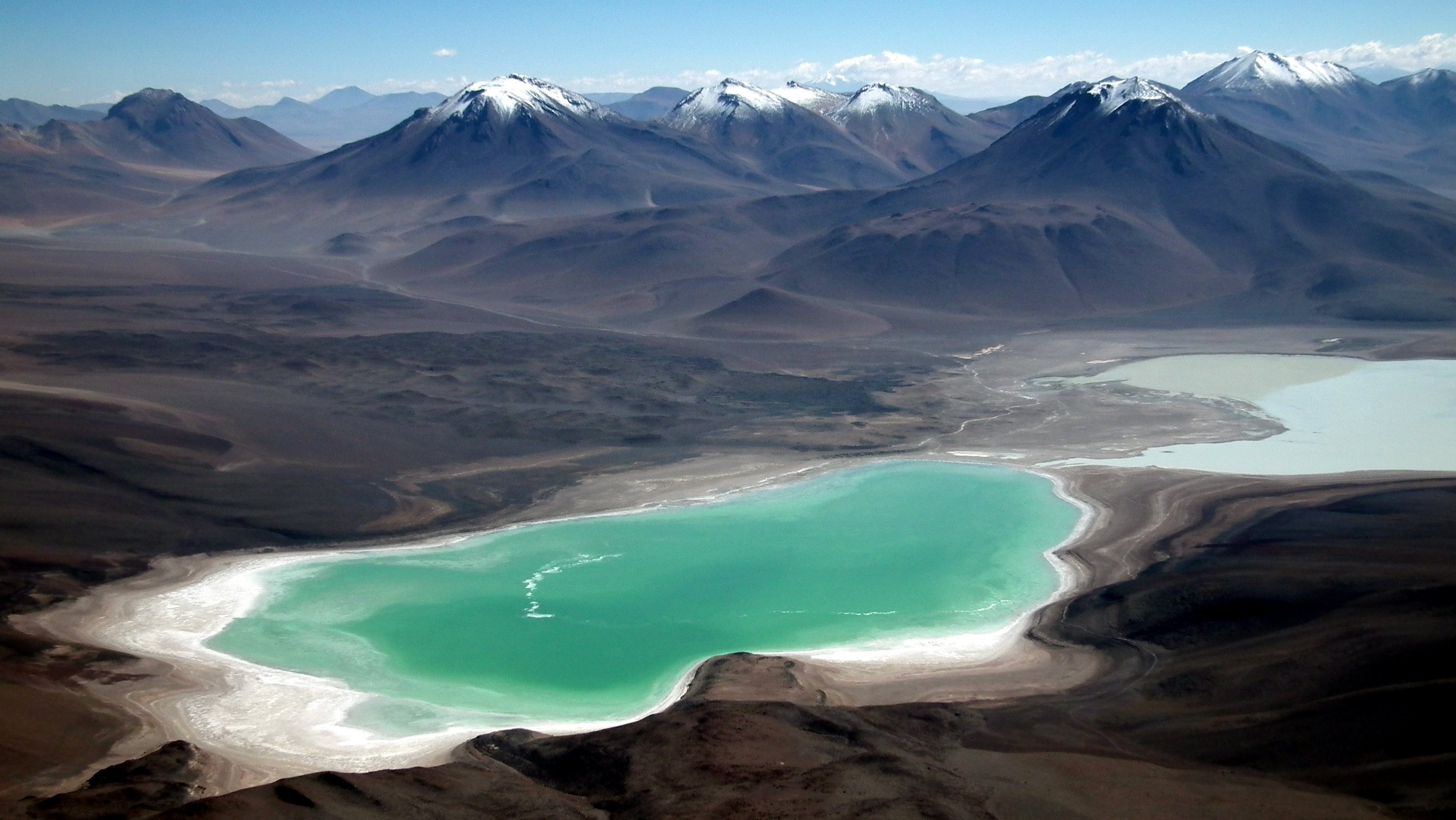
The Summit Day Begins Above 4,600 m and Only Goes Higher.
From the upper route the Altiplano drops away toward Laguna Verde and Laguna Blanca. The extraordinary view is also a reminder of why the route feels so much harder than its simple trail character suggests: almost the entire summit day occurs at elevations where oxygen pressure is dramatically reduced.
Albert Backer · CC BY-SA 3.0 · Wikimedia CommonsThe Four-Day Route Is Better Than Treating Licancabur as a Two-Day Shortcut.
Current commercial two-day ascents exist, but Andeshandbook’s four-day structure deliberately adds a Laguna Verde acclimatization day before the summit.
| Day | Movement | Purpose | Planning note |
|---|---|---|---|
| Day 1 | San Pedro → Hito Cajón → Laguna Verde refuge | Cross border and establish high-altitude base | Sleeping immediately around 4,300 m demands prior acclimatization. |
| Day 2 | Laguna Verde acclimatization day | Move lightly and recover | Use this day to test altitude response rather than spending it inactive. |
| Day 3 | 4×4 approach → Licancabur summit → refuge | Main summit day | Expect roughly 10–12 total hours based on recent successful reports. |
| Day 4 | Bolivia → Hito Cajón → San Pedro | Border return and recovery | Keep enough time for border procedures and transfer delays. |
If you choose a compact program, the days before Licancabur should already include substantial time around 4,000–5,000 meters. The mountain is a poor place to discover that your body has not adapted.
Licancabur Is Easy to Underestimate Because It Looks Walkable.
The absence of sustained technical terrain can create false confidence. A physically strong sea-level hiker can still be overwhelmed by a summit day that begins above 4,600 m and ends near 5,900 m.
Sleep High First
Build several nights at progressively higher elevations before attempting Licancabur. San Pedro alone is not enough acclimatization for many climbers.
Start Slowly
Sustainable pacing is more important than early speed. The steep volcanic cone punishes teams that climb too aggressively during the first hours.
Symptoms Override the Summit
Terrain that remains mechanically easy does not make worsening altitude symptoms acceptable. Descent is the appropriate response when a climber is deteriorating.
Use the Altitude Acclimatization Explained guide to structure sleeping elevations and determine whether a two-, three- or four-day Licancabur program actually fits your altitude history.
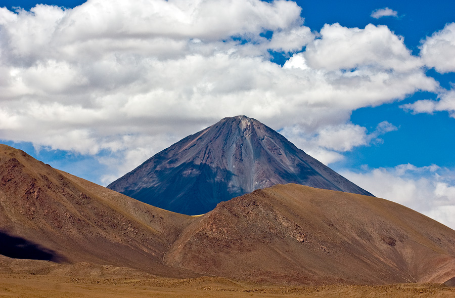
Licancabur Can Be Climbed Year-Round—but the Tradeoffs Change.
Andeshandbook’s current route guide describes the climb as possible throughout the year. Austral summer requires caution because of the Altiplano wet-season storm pattern, while May through August can bring very cold temperatures and shorter days.
There is therefore no single perfect calendar month. The best date is the one that combines adequate acclimatization with stable weather, manageable wind and current route access.
Gerard Prins · CC BY-SA 3.0 · Wikimedia CommonsThe Mountain’s Main Risks Are Not Technical.
Most successful climbers do not fail because they cannot perform a climbing move. They fail because the altitude, cold, wind, dehydration or timing overwhelms the margin they brought to the summit day.
Extreme Altitude
The summit is just below 6,000 m and the walking day begins already at very high elevation.
Wind
The exposed cone offers little shelter. Strong wind can multiply cold stress and dramatically slow the descent.
Pre-Dawn Cold
Recent 2026 climbers specifically reported severe cold around sunrise, even when general weather conditions were otherwise good.
Dry High Desert
Andeshandbook recommends bringing adequate water and lists roughly 2–3 liters of carrying capacity per person.
Winter Snow & Ice
Crampons may become appropriate in winter or after storms even though the route is often dry volcanic terrain.
Remote Border Terrain
Rescue, transport and border complications are very different from climbing a peak directly above a major city.

One of the World’s Highest Persistent Lakes Sits Inside the Crater.
The Smithsonian describes a roughly 400-meter-wide summit crater containing a shallow freshwater lake approximately 70 by 90 meters across. A measured lake temperature of about 6°C has been reported, along with planktonic life.
Scientific work at Licancabur has used the lake as an extreme-environment analogue for astrobiology because liquid water persists at almost 6,000 meters under very low atmospheric pressure, intense ultraviolet radiation, cold temperatures and extremely dry conditions.
Climbers should view the lake from stable crater terrain without entering or disturbing it. Its scientific and archaeological value is substantially greater than its value as a summit-day curiosity.
Albert Backer · CC BY-SA 3.0 · Wikimedia Commons
The “Inca Route” Is Not Just a Modern Name.
Archaeological structures near the upper mountain and crater rim show that people reached Licancabur’s extreme elevations centuries before modern mountaineering.

Modern “First Ascent” Language Needs Context.
Andeshandbook lists Severo Titichoca’s 1884 solo ascent as the first recorded mountaineering ascent of the route.
Yet summit-rim archaeological remains and lower structures demonstrate that pre-Columbian people reached high on Licancabur much earlier. It is therefore more accurate to treat 1884 as the first recorded modern ascent rather than the first human presence on the summit.
Do not camp inside archaeological ruins, move stones, collect artifacts or use historic structures as windbreak material.
Cristian Ordenes · CC BY 2.0 · Wikimedia Commons
Recent Reports Confirm the Route Is Active—but Still Long.
Current firsthand reports are useful because they reveal actual summit times and conditions rather than relying only on generic route descriptions.
7 Hours Up. 3 Hours Down.
A March 2026 Andeshandbook climber reported good weather but significant cold near sunrise and described the climb as hard primarily because of altitude and limited prior acclimatization.
Compare the Service Model Before Comparing the Number.
Licancabur can be sold as a focused two-day summit program from San Pedro or as part of a larger Sud Lípez / Uyuni expedition.
| 2026 example | Program | Published price | Important inclusions / exclusions |
|---|---|---|---|
| Denomades | 2 days / 1 night from San Pedro | CLP 400,000 per person | Transport, instructor, accommodation, meals, poles and Bs150 Eduardo Avaroa reserve ticket listed as included. |
| La Torre Tours | 5-day Tupiza → Uyuni / Licancabur program | US$850 per person based on 4 | Local Licancabur guide listed separately at US$200 per group; attraction entry fees also separate. |
One is a dedicated summit package; the other includes a much larger South Lípez journey. Confirm border transfers, reserve entry, guide, 4×4 approach, accommodation, food, oxygen, private versus shared service and cancellation terms before deciding which offer is actually cheaper.
Where Is Licancabur?
Licancabur sits directly on the Bolivia–Chile frontier east of San Pedro de Atacama and above Laguna Verde in southwestern Bolivia.
A Strong Altitude Volcano Before the Bigger Bolivian Peaks.
Licancabur can be a useful progression objective because it places a climber close to 6,000 meters without introducing a large glacier system.
Altitude + Steep Volcanic Terrain
Nearly 5,900 meters, normally non-glaciated, long summit day and relatively low technical complexity.
Add Glacier Systems
Slightly higher and substantially more technical because glacier, crampon and rope systems become core parts of the normal route.
Add Another 600+ Vertical Meters
Bolivia’s highest mountain adds greater altitude, remoteness and glaciated high-volcano climbing.
Use Licancabur Inside a Broader Andes Progression.
Compare the volcano with higher Bolivian objectives and with the full mountain database before choosing the next step.
Licancabur Climbing FAQ
The most important questions concern which country to climb from, altitude, the long summit day and current reserve logistics.
How high is Licancabur?
Is Licancabur technically difficult?
Which side of Licancabur do you climb from?
How long does Licancabur take?
How long is summit day?
What is the best time to climb Licancabur?
Do I need crampons for Licancabur?
Is there an entrance fee?
Is a guide required for Licancabur?
What is inside the Licancabur crater?
Who first climbed Licancabur?
How much does it cost to climb Licancabur?
Sources Used for This Licancabur Guide
Access, border procedures, protected-area fees and operator prices can change more quickly than the mountain itself. Recheck those details shortly before travel.
Research reviewed September 28, 2026. Verify border status, Eduardo Avaroa reserve procedures, guide requirements, weather and summit conditions before departure.
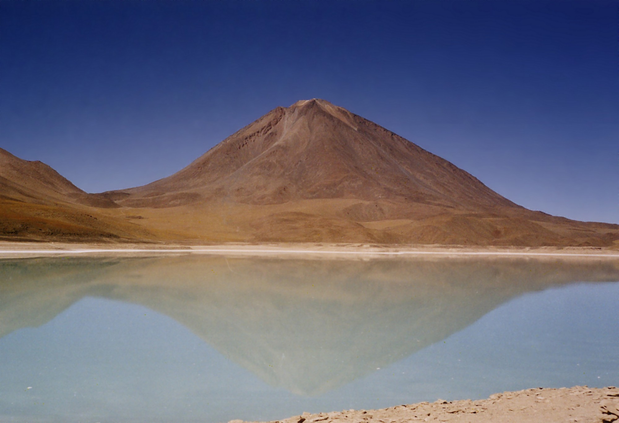
Technically Simple Does Not Mean Physiologically Easy.
Licancabur is at its best as a deliberate altitude objective: acclimatize first, cross into Bolivia correctly, use the established northeast route, carry enough margin for the cold descent and treat the crater’s archaeological and scientific landscape with respect.
Was this helpful?
🏔Related peaks nearby
🧭Explore & compare
Global Summit Guide is an independent mountaineering resource founded in 2026. The team combines first-hand trekking and climbing experience with in-depth research and professional health and nutrition review to help climbers choose objectives, prepare properly, and stay safe.
Health, altitude, and nutrition content is reviewed by Taylor Ludlow (Registered Nurse) and Brigg Hoopes (Nutritionist).
What We Don't Know Yet
Mountain information changes quickly. This box explains the limits of what this page can responsibly promise.
- Visa, passport, vaccination, border, insurance, and local transportation rules may change before your trip.
- Route conditions, snowpack, closures, and weather can change quickly after this page is updated.
- Permit rules, fees, quotas, and reservation windows may change between review cycles.
- Operator availability, pricing, guide ratios, and cancellation terms can change by season.
- Your fitness, altitude response, risk tolerance, and experience level may change what is safe or realistic.
Verify current conditions with official land managers, guide services, local forecasts, and current route reports before booking or climbing.
Mountaineering, rock and ice climbing, glacier travel, and high-altitude activity are inherently dangerous and can result in serious injury or death. The information on Global Summit Guide is provided for general informational and educational purposes only and is not a substitute for professional instruction, qualified guiding, proper equipment, or your own judgment and experience.
Route conditions, weather, snowpack, permits, regulations, and hazards change constantly and may differ from what is described here. Details may be incomplete, out of date, or contain errors. Always verify current information with local authorities, certified guides, and official sources before making any decision in the mountains.
Nothing on this site is medical, legal, or financial advice. Our fitness, acclimatization, altitude, and nutrition content is general in nature; consult a qualified physician before beginning any strenuous exercise program or exposing yourself to high altitude.
You are solely responsible for your own safety and decisions. To the fullest extent permitted by law, Global Summit Guide and its team accept no liability for any loss, injury, damage, or expense arising from use of, or reliance on, this information. By using this site you acknowledge these risks and accept these terms.
Some links on this site may be affiliate links. If you buy through them we may earn a small commission at no extra cost to you; this never affects our recommendations.
Global Summit Guide recommendation path
Next Best Mountain to Research
Use these recommendations to continue the right planning path instead of stopping on one page.
Use current permit, weather, route, and operator information before booking or climbing.