
Last updated September 8, 2026

Capitol Reef Hiking Guide: The 12 Best Hikes, Seasons & Trip Plan
Navajo Knobs is the best big viewpoint day in Capitol Reef; Cassidy Arch is the strongest shorter slickrock objective; Hickman Bridge is the best moderate first hike. The park is quieter than Utah’s better-known canyon parks, but planning still depends on heat, flash-flood exposure, trailhead parking and road conditions that can change after a single storm.
What Are the Best Hikes in Capitol Reef?
Choose Navajo Knobs when you want the park’s strongest full hiking day. The route extends beyond Rim Overlook to a high sandstone viewpoint with a 360-degree panorama over the Waterpocket Fold. The National Park Service lists it at 4.7 miles one way and 1,620 feet of elevation change.
Choose Cassidy Arch when you want a shorter strenuous route with the most distinctive slickrock finish. It is 1.7 miles one way with 670 feet of gain. For a moderate first hike, Hickman Bridge gives you a 133-foot natural bridge in a normal out-and-back of about 1.8 miles.
Grand Wash is the easy canyon walk. Chimney Rock is the best compact loop. Sulphur Creek is the adventurous exception: a 5.8-mile one-way, unmaintained water-and-scrambling route that requires stronger route judgment and a shuttle plan.
12 Hikes Worth Building a Trip Around
NPS publishes many Fruita-area trail distances as one-way figures. Round-trip distances below are calculated only for straightforward out-and-back routes; loops and point-to-point routes are labeled separately.
| Hike | Planning distance | Elevation change | NPS rating / style | Best for |
|---|---|---|---|---|
| 1. Navajo Knobs | 9.4 mi RT | 1,620 ft | Strenuous | Best big viewpoint day |
| 2. Cassidy Arch | 3.4 mi RT | 670 ft | Strenuous / slickrock | Best short strenuous hike |
| 3. Hickman Bridge | 1.8 mi RT | 400 ft | Moderate | Best first hike |
| 4. Grand Wash | Up to 4.4 mi RT | 200 ft one way | Easy canyon | Best easy narrows experience |
| 5. Chimney Rock Loop | 3.6 mi loop | 590 ft | Strenuous | Best compact loop / sunset |
| 6. Rim Overlook | 4.6 mi RT | 1,110 ft | Strenuous | Shorter alternative to Navajo Knobs |
| 7. Cohab Canyon | 3.4 mi RT | 440 ft | Moderate | Hidden canyon + Fruita views |
| 8. Golden Throne | 4.0 mi RT | 730 ft | Strenuous | Capitol Gorge views when access works |
| 9. Fremont Gorge Overlook | 4.6 mi RT | 1,090 ft | Strenuous | Open mesa + gorge rim |
| 10. Fremont River | 2.0 mi RT | 480 ft | Moderate | River start + steep panorama |
| 11. Sunset Point | 0.8 mi RT | <50 ft | Easy | Best short sunset walk |
| 12. Sulphur Creek | 5.8 mi one way | Route terrain | Unmaintained route | Water, scrambling + navigation |
Source note: Fruita trail distance, elevation and difficulty data are from the National Park Service trail guide. Sulphur Creek has its own NPS route description because it is not an official maintained trail.
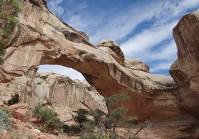
The Best First Hike Does Not Need to Be the Longest.
Hickman Bridge is short enough for an arrival day and substantial enough to introduce Capitol Reef’s sandstone, canyon terrain and elevation. It is the cleanest moderate starting point before committing to a bigger slickrock day.
Photo: National Park Service.
Cassidy Arch: The Strongest Short Strenuous Hike
1.7 miles one way · 670 ft elevation change · strenuous · Grand Wash trailhead
A Short Route That Still Feels Like Capitol Reef
Cassidy Arch earns its place near the top because the hiking is more interesting than the mileage suggests. The route leaves Grand Wash, climbs steeply above the canyon and crosses open sandstone before reaching the broad arch. You get canyon depth, slickrock movement and a high viewpoint in a normal out-and-back of about 3.4 miles.
It is a particularly useful choice when you have only half a day but still want a route with real vertical gain rather than a roadside viewpoint.
Grand Wash Access and Summer Heat
The route begins from the Grand Wash corridor, so current road and flood conditions matter. As of September 6, 2026, NPS lists the Grand Wash road as 2WD, but that status can change quickly after storms.
The slickrock is exposed. In hot weather, start early and do not let the short distance convince you to carry less water than the conditions demand.
Which Capitol Reef Hike Fits Your Trip?
The most useful ranking changes with time, temperature, experience and whether the forecast makes narrow terrain a poor choice.
Hickman Bridge or Sunset Point
Hickman Bridge gives you a real moderate hike. Sunset Point is the better answer for an easy arrival walk, mixed-ability group or final evening.
Cassidy Arch or Chimney Rock
Cassidy Arch wins for slickrock and a destination. Chimney Rock wins for a loop, broad Waterpocket Fold views and a compact workout.
Navajo Knobs
If the weather is stable and the temperature works, Navajo Knobs is the clearest answer for hikers who want the strongest single hiking day in the Fruita district.
Grand Wash
Choose Grand Wash for sheer walls and narrows without the climbing effort of the high viewpoints. Avoid washes when storms threaten.
Sulphur Creek
This is not a maintained trail. Choose it only when rain risk is low and your party is comfortable with navigation, water travel and short downclimbs.
Fremont Gorge Overlook
A strong alternative when you want a sustained climb and panorama without making Navajo Knobs the entire day.
One, Two or Three Days in Capitol Reef
These are planning frameworks, not rigid schedules. Heat, road conditions and flood potential should be allowed to move the route order.
- Early: Hickman Bridge or Cassidy Arch.
- Midday: Fruita, visitor center and orchards.
- Afternoon: Scenic Drive if current conditions allow.
- Evening: Sunset Point or Goosenecks.
If hiking is the priority, swap the short morning route for Navajo Knobs and keep the rest of the day intentionally light.
- Day 1: Cassidy Arch + Grand Wash, with Fruita afterward.
- Day 2: Navajo Knobs early.
- Keep Rim Overlook as the Day 2 heat/time turnaround.
This is the strongest two-day hiking plan for most fit visitors because it combines slickrock, canyon terrain and the park’s major high panorama.
- Days 1-2: use the two-day plan.
- Day 3: Sulphur Creek in safe weather, or a Waterpocket/remote route with current road information.
- If roads are poor, stay in Fruita and use Cohab Canyon, Chimney Rock or Fremont Gorge.
Do not force Cathedral Valley or Waterpocket driving into the itinerary when the road report says no.
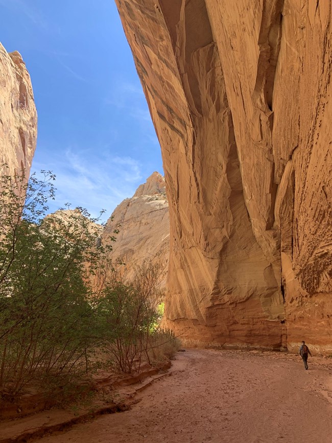
Capitol Reef Gets Bigger the Moment You Leave Fruita.
Spring Canyon, Sulphur Creek and the Waterpocket routes add navigation, water uncertainty, road logistics and much greater self-sufficiency. They are not simply longer versions of the frontcountry trails.
Photo: NPS / S. Cotrell.
When Is the Best Time to Hike Capitol Reef?
Spring and fall are the strongest broad windows. Summer can work, but the best route at sunrise may be the wrong route by afternoon.
| Season | What it feels like | Best use | Main planning problem |
|---|---|---|---|
| March-April | Cool to mild, variable storms | Long exposed hikes | Cold fronts, occasional snow/ice, muddy roads |
| May-June | Rapidly warming; June hot | Early starts, frontcountry classics | Heat and sun exposure |
| July-August | Hot + monsoon | Short sunrise hikes; flexible itinerary | Heat, thunderstorms, flash floods |
| September-October | Strong hiking temperatures; monsoon can linger | Best all-around hiking trip | Storms, shorter days, road changes |
| November-February | Quiet, cold, possible snow | Low-crowd frontcountry hiking | Freezing nights, ice, short daylight |
NPS climate normals at the visitor center show average highs around 91 F in July, 88 F in August and 80 F in September. The park also notes that much of its annual precipitation arrives during the summer monsoon, so a cooler-looking cloud build-up is not automatically good news for a canyon hike.
Heat and Flash Floods Deserve Separate Decisions
Short Mileage Can Still Mean High Exposure
Many Capitol Reef trails have little reliable shade or water. NPS notes that high temperatures can reach the upper 90s as early as May and may exceed 100 F. Long slickrock routes such as Navajo Knobs are best moved early rather than simply supplied with more optimism.
NPS recommends at least one gallon of water per person per day for normal desert hiking, with more for backpacking. Your actual need varies with temperature, pace, duration and individual physiology.
A Sunny Trailhead Does Not Clear the Wash
From mid-June into mid-October, monsoon storms can produce intense localized rain. NPS warns that storms outside the immediate park can send water into canyons where the sky overhead still looks clear.
Avoid Grand Wash, Capitol Gorge, Sulphur Creek and other narrow drainage terrain when storms threaten. Check the National Weather Service flash-flood potential before starting.
Capitol Reef Does Not Use Timed Entry
That makes arrival simpler than some national-park trips, but parking and activity-specific permits still matter.
| Item | Current rule | What it means for hikers |
|---|---|---|
| Timed entry | Not required | You do not need a park-entry reservation, but popular trailhead lots can still fill. |
| Private vehicle | $20 / 7 days | Covers the vehicle and passengers. |
| Motorcycle | $15 / 7 days | Current standard motorcycle entry. |
| Walk / bicycle | $10 age 16+ | Individual entry without a vehicle. |
| Capitol Reef annual pass | $35 | Useful for repeat visits. |
| Normal day hiking | No separate hiking permit | Use the entrance pass and current trail/road information. |
| Backpacking | Free permit required | Obtain before an overnight backcountry trip. |
| Canyoneering / climbing groups | Permit required | Do not treat technical canyon objectives as ordinary hiking. |
Connectivity is limited in the park. NPS recommends downloading a digital pass to your device before arrival or carrying a printed copy.
Do Not Build a Remote Capitol Reef Day From an Old Road Report
The Fruita district is the easiest part of the park to plan. Cathedral Valley and the Waterpocket District can change from feasible to impassable after weather.
The Reliable Hiking Base
As of the September 6 NPS road update, Scenic Drive and Grand Wash are 2WD. Capitol Gorge is closed. South Draw is HC4WD, very rough and not recommended. Pleasant Creek is 2WD and Sulphur Creek is HC2WD.
For a first trip, build around Fruita and treat the road-dependent extensions as bonuses.
Vehicle Choice Is Part of the Route
As of the same update, several Cathedral Valley roads are impassable, and Cathedral Valley is HC4WD to the Temples but impassable beyond. In the Waterpocket District, Notom-Bullfrog and Burr Trail are currently HC2WD while several farther routes have unknown status.
NPS defines high clearance here as at least eight inches. Conditions can change faster than the website’s weekly update cycle.
Torrey Outside. Fruita Inside.
Best Base for Lodging and Food
Torrey is the cleanest base for most visitors who want a bed, restaurant options and quick access to the Fruita district. It also works well for a Highway 12 road trip that pairs Capitol Reef with Bryce Canyon and Grand Staircase-Escalante.
For a hiking-heavy trip, prioritize a base that makes an early trailhead start easy rather than choosing lodging only by resort amenities.
Stay Inside the Park
Fruita is Capitol Reef’s only developed campground. NPS lists 71 sites, a $25 nightly fee and a 100% reservation system, with sites reservable up to six months ahead. Demand is highest from mid-March through October and the campground can fill months ahead.
The setting is unusual for Utah canyon country: orchards, the Fremont River and irrigated green space sit directly beneath red cliffs.
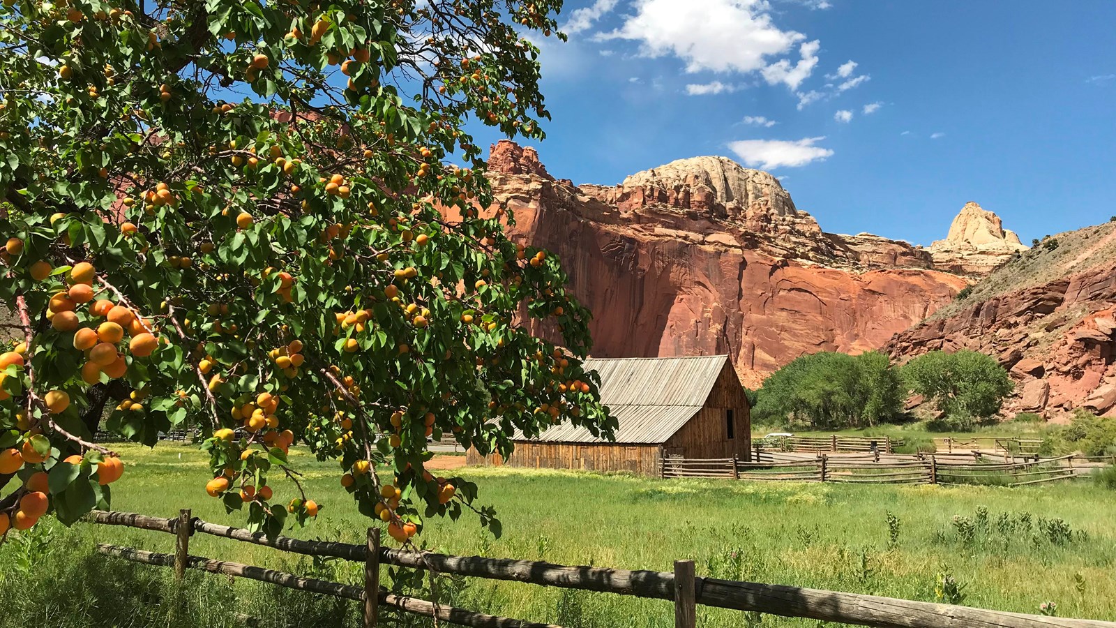
Capitol Reef Has a Green Center Most Desert Parks Do Not.
The Fruita orchards turn a hiking trip into something more varied. In harvest season, open orchards can offer fruit picking between hikes; the exact orchard and fruit change through the season, so use the park’s current orchard update rather than an old calendar.
Photo: NPS / Shauna Cotrell.
Waterpocket and Backcountry Routes Are a Different Planning Category
Once you leave the maintained frontcountry network, the questions shift toward navigation, road access, water, flood exposure and overnight permits.
Adventure Without an Overnight
The NPS description makes the boundary clear: 5.8 miles one way, shallow-to-deep water, three waterfalls, short scrambles and route-finding. You need a shuttle vehicle at each end or an additional 3.3-mile highway walk. The park does not provide or facilitate the shuttle.
Do not hike it when rain is possible. NPS also recommends against fully submerging in or ingesting Sulphur Creek water because E. coli can be present.
Navigation and Self-Sufficiency Increase Fast
Spring Canyon is partly unmarked; NPS specifically recommends topographic mapping and GPS and describes potential water sources as rare and uncertain. The Waterpocket District adds remote canyon routes where road conditions may matter as much as trail difficulty.
For overnight backcountry travel, a free permit is required. Do not turn a successful Navajo Knobs day into proof that you are ready for an unmaintained multi-day canyon.
If this kind of route appeals to you, build the navigation system before the trip: download maps, carry a second way to identify your position, and know how you will turn around when the route stops matching expectation.
What to Recheck Before You Drive to the Trailhead
Trail geometry changes slowly. Road status, flood potential, orchards, fees and activity rules can change much faster.
Trail Guide + Current Conditions
Use the official trail guide for published trail distance, elevation and difficulty. Use the current-conditions page for road status, seasonal operations and orchard updates.
NPS trail guide → Current conditions →Weather + Flash-Flood Potential
Capitol Reef publishes separate forecast links for Fruita, the north district and the south district. Check the exact district you are entering, plus the regional flash-flood rating.
Capitol Reef weather →Fees + Permits
Recheck entrance prices and whether your specific activity needs a permit. Ordinary day hiking does not use timed entry; backcountry overnight travel and canyoneering have separate requirements.
Fees → Permits →Sulphur Creek + Backcountry Routes
Use the route-specific NPS descriptions before leaving a maintained trail. Conditions, obstacles and water depth can change after floods.
Sulphur Creek →Capitol Reef Hiking FAQ
What is the best hike in Capitol Reef?
For a full hiking day, choose Navajo Knobs. NPS lists it at 4.7 miles one way with 1,620 feet of elevation change, ending in a 360-degree panorama. Cassidy Arch is the better shorter strenuous route; Hickman Bridge is the strongest moderate first hike.
How long is Navajo Knobs?
NPS lists Navajo Knobs at 4.7 miles one way and 1,620 feet of elevation change. A normal out-and-back is therefore about 9.4 miles. Rim Overlook is an earlier turnaround at 2.3 miles one way.
How long is Cassidy Arch?
NPS lists Cassidy Arch at 1.7 miles one way with 670 feet of elevation change. The normal out-and-back is about 3.4 miles.
Do I need a timed-entry reservation?
No. NPS states that Capitol Reef does not require a reservation or timed-entry ticket to enter the park. Popular trailhead parking can still fill, especially during spring and fall.
How much does Capitol Reef cost?
The current standard private-vehicle pass is $20 and is valid for seven days. A motorcycle is $15 and individual entry without a vehicle is $10 for visitors age 16 and older. Recheck the NPS fee page before departure.
When is the best time to hike Capitol Reef?
Spring and fall are the strongest broad seasons for exposed desert hiking. Summer is much hotter and overlaps with the monsoon/flash-flood season. Winter is quiet but can bring snow, ice, freezing nights and short daylight.
Where should I stay?
Torrey is the most practical outside-the-park base for lodging, food and early access to Fruita. Fruita Campground is the only developed campground inside the park and has 71 reservable sites.
Is Grand Wash safe when rain is forecast?
Do not enter narrow washes and gorges when storms threaten. NPS warns that flash flooding can occur even when the immediate sky looks clear because storms elsewhere in the drainage can send water into the canyon.
Is Sulphur Creek a trail?
NPS explicitly says Sulphur Creek is not an official maintained trail. It is a 5.8-mile one-way route involving water, navigation and short scrambles, with a shuttle or additional highway walk required.
Can I visit Cathedral Valley in a normal car?
Do not assume so. Road requirements change with weather. As of the September 6, 2026 NPS update, several Cathedral Valley roads are impassable and the route is HC4WD only to the Temples, impassable beyond. Check the latest road report before committing.
Cassidy Arch for the Short Day. Navajo Knobs for the Big Day. Let Weather Choose the Canyon.
Capitol Reef is at its best when you do not try to collect every trail. Give one day to slickrock and Fruita, one day to a major viewpoint, and keep the final choice flexible enough to respond to road, heat and flash-flood conditions.
Keep Building the Utah Trip
Capitol Reef is one piece of Utah’s hiking system. Compare the statewide parent, canyon-country siblings and Utah’s mountain side below.
Was this helpful?
🏔Related peaks nearby
🧭Explore & compare
Global Summit Guide is an independent mountaineering resource founded in 2026. The team combines first-hand trekking and climbing experience with in-depth research and professional health and nutrition review to help climbers choose objectives, prepare properly, and stay safe.
Health, altitude, and nutrition content is reviewed by Taylor Ludlow (Registered Nurse) and Brigg Hoopes (Nutritionist).
What We Don't Know Yet
Mountain information changes quickly. This box explains the limits of what this page can responsibly promise.
- Visa, passport, vaccination, border, insurance, and local transportation rules may change before your trip.
- Route conditions, snowpack, closures, and weather can change quickly after this page is updated.
- Permit rules, fees, quotas, and reservation windows may change between review cycles.
- Operator availability, pricing, guide ratios, and cancellation terms can change by season.
- Your fitness, altitude response, risk tolerance, and experience level may change what is safe or realistic.
Verify current conditions with official land managers, guide services, local forecasts, and current route reports before booking or climbing.
Mountaineering, rock and ice climbing, glacier travel, and high-altitude activity are inherently dangerous and can result in serious injury or death. The information on Global Summit Guide is provided for general informational and educational purposes only and is not a substitute for professional instruction, qualified guiding, proper equipment, or your own judgment and experience.
Route conditions, weather, snowpack, permits, regulations, and hazards change constantly and may differ from what is described here. Details may be incomplete, out of date, or contain errors. Always verify current information with local authorities, certified guides, and official sources before making any decision in the mountains.
Nothing on this site is medical, legal, or financial advice. Our fitness, acclimatization, altitude, and nutrition content is general in nature; consult a qualified physician before beginning any strenuous exercise program or exposing yourself to high altitude.
You are solely responsible for your own safety and decisions. To the fullest extent permitted by law, Global Summit Guide and its team accept no liability for any loss, injury, damage, or expense arising from use of, or reliance on, this information. By using this site you acknowledge these risks and accept these terms.
Some links on this site may be affiliate links. If you buy through them we may earn a small commission at no extra cost to you; this never affects our recommendations.
Global Summit Guide recommendation path
Next Best Mountain to Research
Use these recommendations to continue the right planning path instead of stopping on one page.
Use current permit, weather, route, and operator information before booking or climbing.
Search Flights, Hotels & Rental Cars
Have the mountain or destination picked? Use Expedia to compare the flights, lodging and rental cars that fit your actual trip dates. For mountain travel, consider arriving early enough for delays and adding a buffer night after the climb before a fixed flight home.
Compare current flight, hotel and car options.
Affiliate disclosure: Global Summit Guide may earn a commission if you book through this link, at no additional cost to you.